Grade II* listed buildings in Chesterfield
There are over 20,000 Grade II* listed buildings in England. This page is a list of these buildings in the district of Chesterfield in Derbyshire.
Listed buildings
| Name | Location | Type | Completed [note 1] | Date designated | Grid ref.[note 2] Geo-coordinates |
Entry number [note 3] | Image |
|---|---|---|---|---|---|---|---|
| Tapton Grove | Tapton, Brimington | House | c.1800 | 26 September 1977 | SK4013672436 53°14′51″N 1°24′00″W |
1068875 |  |
| Church of St John the Baptist | Staveley | Church | 13th century and later medieval | 25 February 1966 | SK4335474869 53°16′09″N 1°21′05″W |
1334670 |  Church of St John the Baptist |
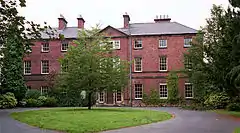
| The Hagge | Nether Handley, Staveley | Country house | 1630 | 25 February 1966 | SK4119476542 53°17′03″N 1°23′01″W |
1205056 | |
| Bank Close (now care home) | Chesterfield | House | Earlier 19th century | 26 September 1977 | SK3880270207 53°13′39″N 1°25′13″W |
1088274 | |
| Gazebo at Brampton Manor | Brampton | Gazebo | Early 18th century | 13 March 1968 | SK3632071119 53°14′09″N 1°27′26″W |
1088267 | |
| Mill buildings at Walton Works | Chesterfield | Mill | Late 18th century | 27 September 2004 | SK3677170735 53°13′57″N 1°27′02″W |
1391084 |  Mill buildings at Walton Works |
| Pagets Insurances Ltd and area railings | Chesterfield | Terrace | Late 18th century | 15 July 1971 | SK3818671326 53°14′15″N 1°25′46″W |
1088238 |  Pagets Insurances Ltd and area railings |
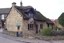
| Revolution House | Whittington | House | 17th century | 13 March 1968 | SK3838774957 53°16′13″N 1°25′33″W |
1088283 | |
| Roman Catholic Eyre Chapel (behind Newbold Road) | Chesterfield | Chapel | Medieval | 13 March 1968 | SK3687472868 53°15′06″N 1°26′56″W |
1374497 |  Roman Catholic Eyre Chapel (behind Newbold Road) |
| Tapton House | Tapton | House | Late 18th century | 13 March 1968 | SK3921372156 53°14′42″N 1°24′50″W |
1088335 | |
| The Gazebo at Somersall Hall | Somersall | Gazebo | Early 17th century | 13 March 1968 | SK3525469967 53°13′32″N 1°28′24″W |
1203393 | |
| The Royal Oak Inn | Chesterfield | Public house | 16th century | 15 July 1971 | SK3829471080 53°14′07″N 1°25′40″W |
1334732 |  The Royal Oak Inn |
| The Town Pump | Chesterfield | Water pump | Early/mid-19th century | 9 August 1976 | SK3821771100 53°14′08″N 1°25′44″W |
1088256 | 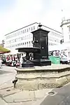 The Town Pump |
| Unitarian Chapel | Chesterfield | Chapel | 1694 | 15 July 1971 | SK3832571245 53°14′13″N 1°25′38″W |
1088233 |  Unitarian Chapel |
| 2 St Mary's Gate | Chesterfield | House | Early 17th century | 13 March 1968 | SK3856071205 53°14′11″N 1°25′25″W |
1025866 |  2 St Mary's Gate |
| 9 Beetwell Street | Chesterfield | House | Late 16th or early 17th century | 9 August 1976 | SK3835270933 53°14′03″N 1°25′37″W |
1075161 |  9 Beetwell Street |
| 42 St Mary's Gate | Chesterfield | House | Mid-18th century | 4 September 1972 | SK3853271016 53°14′05″N 1°25′27″W |
1088231 |  42 St Mary's Gate |
See also
- Grade I listed buildings in Derbyshire
- Grade II* listed buildings in Derbyshire
- Grade II* listed buildings in Amber Valley
- Grade II* listed buildings in Bolsover (district)
- Grade II* listed buildings in Derby
- Grade II* listed buildings in Derbyshire Dales
- Grade II* listed buildings in Erewash
- Grade II* listed buildings in High Peak
- Grade II* listed buildings in North East Derbyshire
- Grade II* listed buildings in South Derbyshire
Notes
- The date given is the date used by Historic England as significant for the initial building or that of an important part in the structure's description.
- Sometimes known as OSGB36, the grid reference is based on the British national grid reference system used by the Ordnance Survey.
- The "List Entry Number" is a unique number assigned to each listed building and scheduled monument by Historic England.
External links
![]() Media related to Grade II* listed buildings in Derbyshire at Wikimedia Commons
Media related to Grade II* listed buildings in Derbyshire at Wikimedia Commons
This article is issued from Wikipedia. The text is licensed under Creative Commons - Attribution - Sharealike. Additional terms may apply for the media files.