Grade II* listed buildings in Barrow-in-Furness (borough)
There are over 20,000 Grade II* listed buildings in England. This page is a list of these buildings in the district of Barrow-in-Furness in Cumbria.
List of buildings
| Name | Location | Type | Completed [note 1] | Date designated | Grid ref.[note 2] Geo-coordinates |
Entry number [note 3] | Image |
|---|---|---|---|---|---|---|---|
| Gate piers and wall enclosing forecourt at Marsh Grange | Ireleth, Askam and Ireleth | Gate | Late 17th to early 18th century | 25 February 1950 | SD2212379707 54°12′26″N 3°11′44″W |
1218964 |  |
| Marsh Grange Farmhouse | Ireleth, Askam and Ireleth | Farmhouse | Early 17th century | 25 February 1950 | SD2209079715 54°12′26″N 3°11′46″W |
1201091 | |
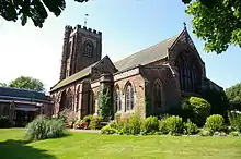
| Church of St Mary | Dalton-in-Furness | Church | 1882–85 | 25 February 1950 | SD2258073886 54°09′18″N 3°11′13″W |
1209758 | |
| Tytup Hall | Tytup, Dalton Town with Newton | Country house | c.1710 | 25 February 1950 | SD2357675980 54°10′26″N 3°10′20″W |
1208891 | |
| Abbey House Hotel | Barrow-in-Furness | Town house | 1910–14 | 10 November 1949 | SD2168872094 54°08′19″N 3°12′01″W |
1197910 | |
| Barn immediately to rear of Sowerby Hall Farmhouse | Barrow-in-Furness | Barn | Late 16th to early 17th century | 20 December 1993 | SD1986172464 54°08′30″N 3°13′42″W |
1283032 | |
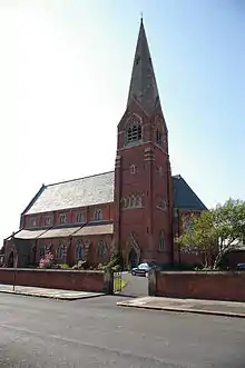
| Church of St James | Barrow-in-Furness | Church | 1867–69 | 6 May 1976 | SD1946069944 54°07′09″N 3°14′01″W |
1197881 | |
| Devonshire Buildings | Barrow Island, Barrow-in-Furness | Tenement block | c.1875 | 6 May 1976 | SD1961868327 54°06′16″N 3°13′51″W |
1197845 | |
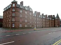
| Devonshire Buildings, Island Road Mission, the Devonshire Public House | Barrow Island | Tenement block | 1872–74 | 6 May 1976 | SD1955668196 54°06′12″N 3°13′54″W |
1218436 | 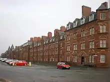 Devonshire Buildings, Island Road Mission, the Devonshire Public House |
| Ormsgill Farmhouse | Ormsgill | Farmhouse | 1605 | 10 November 1949 | SD1918871366 54°07′54″N 3°14′18″W |
1218612 | |
| Park House Farmhouse | Barrow-in-Furness | Farmhouse | 16th century | 10 November 1949 | SD2236671038 49°46′01″N 7°33′26″W |
1197851 | |
| Sloop Street Tenements | Barrow Island | Workers cottage | 1881–84 | 20 December 1993 | SD1961468095 54°06′09″N 3°13′51″W |
1201084 | 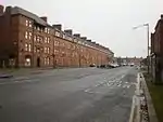 Sloop Street Tenements |
| Steamer Street Tenements | Barrow Island | Workers cottage | 1881–84 | 20 December 1993 | SD1967668226 54°06′13″N 3°13′48″W |
1282852 |  Steamer Street Tenements |
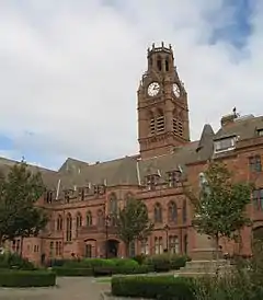
| Town Hall | Barrow-in-Furness | Town hall | 1882–87 | 6 May 1976 | 49°46′01″N 7°33′26″W | 1197859 | |
| Walney Lighthouse with two attached cottages and outbuildings | Walney Island | House | 1790 | 6 May 1976 | SD2301962058 54°02′55″N 3°10′38″W |
1218858 |  Walney Lighthouse with two attached cottages and outbuildings |
Notes
- The date given is the date used by Historic England as significant for the initial building or that of an important part in the structure's description.
- Sometimes known as OSGB36, the grid reference is based on the British national grid reference system used by the Ordnance Survey.
- The "List Entry Number" is a unique number assigned to each listed building and scheduled monument by Historic England.
External links
This article is issued from Wikipedia. The text is licensed under Creative Commons - Attribution - Sharealike. Additional terms may apply for the media files.