Grade II* listed buildings in Chiltern
There are over 20,000 Grade II* listed buildings in England. This page is a list of these buildings in the district of Chiltern in Buckinghamshire.
List
| Name | Location | Type | Completed [note 1] | Date designated | Grid ref.[note 2] Geo-coordinates |
Entry number [note 3] | Image |
|---|---|---|---|---|---|---|---|
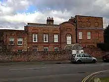
| Elmodesham House | Amersham | House | Early 18th century | 22 December 1958 | SU9563497337 51°40′00″N 0°37′07″W |
1274720 |  |
| Friends' Meeting House and Whielden Cottage | Amersham | Meeting house | c.1600 | 22 December 1958 | SU9560997044 51°39′51″N 0°37′09″W |
1274183 | |
| High and Over with attached walls, steps and pergola | Highover Park, Amersham | Country house | 1928–31 | 28 January 1971 | SU9662997394 51°40′01″N 0°36′15″W |
1237711 | 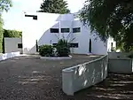 High and Over with attached walls, steps and pergola |
| Market Hall | Amersham | Market hall | 1682 | 22 December 1958 | SU9575497322 51°39′59″N 0°37′01″W |
1221420 | 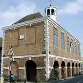 Market Hall |
| Sir William Drake's Almshouse | Amersham | Almshouses | 1657 | 22 December 1958 | SU9545897408 51°40′02″N 0°37′16″W |
1222353 | 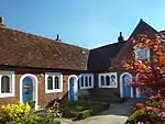 Sir William Drake's Almshouse |
| The Gables | 27 High Street, Amersham | House | Late 16th century | 22 December 1958 | SU9573597337 51°40′00″N 0°37′02″W |
1221468 | 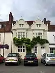 The Gables |
| The King's Arms Hotel | Amersham | Cross-wing house | 16th century | 22 December 1958 | SU9567697323 51°40′00″N 0°37′05″W |
1274789 |  The King's Arms Hotel |
| 56, 58, 60 High Street | Amersham | Timber-framed house | 16th century | 22 December 1958 | SU9557097366 51°40′01″N 0°37′10″W |
1222344 | 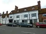 56, 58, 60 High Street |
| Parish Church of St John the Evangelist | Ashley Green | Parish church | 1873 | 30 July 1984 | SP9765405206 51°44′13″N 0°35′14″W |
1124856 | 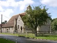 Parish Church of St John the Evangelist |
| The Old Rectory | Chalfont St Giles | House | Late 17th century | 22 December 1958 | SU9891693449 51°37′52″N 0°34′20″W |
1125008 | |
| The Vache | Chalfont St Giles | House | 15th century | 22 December 1958 | SU9963794495 51°38′26″N 0°33′42″W |
1161651 | |
| Parish Church of St Peter | Chalfont St Peter | Church | Medieval | 22 December 1958 | TQ0004690873 51°36′28″N 0°33′24″W |
1311461 | 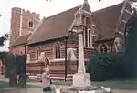 Parish Church of St Peter |
| Shrub's Wood including attached walls and planting boxes surrounding garage court and patio | Chalfont St Peter | House | 1933–34 | 30 July 1984 | TQ0051394213 51°38′16″N 0°32′56″W |
1158476 | |
| Chapel at Great Hundridge Manor | Hyde Heath, Chartridge | House | 1958 | 22 December 1958 | SP9326701619 51°42′20″N 0°39′06″W |
1124900 | |
| Great Hundridge Manor | Hyde Heath, Chartridge | House | Late 17th century | 22 December 1958 | SP9323401628 51°42′20″N 0°39′08″W |
1162783 | |
| Chenies Chapel (Baptist) | Chenies | Baptist chapel | 1770s | 30 July 1984 | TQ0211098135 51°40′22″N 0°31′29″W |
1124803 | 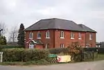 Chenies Chapel (Baptist) |
| Great Germains | Chesham | Timber-framed house | Mediaeval | 10 November 1951 | SP9569601163 51°42′04″N 0°37′00″W |
1124621 | |
| Hollybush Farmhouse | Chesham | Farmhouse | Early 17th century | 7 September 1973 | SP9731902112 51°42′34″N 0°35′34″W |
1311573 | |
| Little Germains | Chesham | House | c.1540 | 10 November 1951 | SP9553700976 51°41′58″N 0°37′08″W |
1158567 | |
| Vale Farmhouse | Chesham Vale, Chesham | Farmhouse | Late 15th century | 10 November 1951 | SP9621303448 51°43′17″N 0°36′31″W |
1311545 | |
| 54 and 56 Church Street | Chesham | Timber-framed house | 14th century | 10 November 1951 | SP9575501462 51°42′13″N 0°36′57″W |
1332597 | 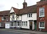 54 and 56 Church Street |
| Church of St Leonard | St Leonards, Cholesbury-cum-St. Leonards | Chapel of Ease | 15th century | 22 December 1958 | SP9099807065 51°45′18″N 0°40′59″W |
1162947 | 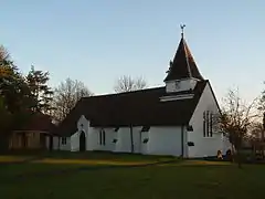 Church of St Leonard |
| Church of All Saints | Coleshill | Church | 1861 | 22 December 1958 | SU9474495137 51°38′49″N 0°37′55″W |
1239441 | 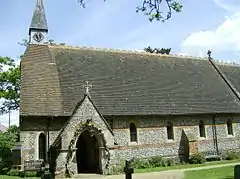 Church of All Saints |
| Abbey Farmhouse | Great Missenden | Timber-framed house | Early 15th century | 30 July 1984 | SP8970701131 51°42′06″N 0°42′12″W |
1158934 | 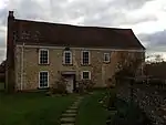 Abbey Farmhouse |
| Barn at rear of the George Public House | Great Missenden | Court house | 15th century or early 16th century | 22 December 1958 | SP8953801120 51°42′06″N 0°42′21″W |
1124795 | 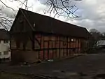 Barn at rear of the George Public House |
| Elmhurst (Flats Nos 1–7 consec.) | Great Missenden | Apartment | Late 16th century | 5 August 1977 | SP8928401582 51°42′21″N 0°42′33″W |
1332522 | |
| The George Public House | Great Missenden | House | Late 15th century or early 16th century | 30 July 1984 | SP8954501130 51°42′06″N 0°42′20″W |
1159193 |  The George Public House |
| Beel House | Little Chalfont | Country house | Earlier | 22 December 1958 | SU9878897414 51°40′01″N 0°34′23″W |
1238695 | |
| Church of the Holy Trinity | Penn Street, Penn | Church | 1849 | 22 December 1958 | SU9236296247 51°39′27″N 0°39′58″W |
1124951 | 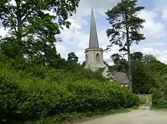 Church of the Holy Trinity |
| Holly Mount | Knotty Green, Penn | House | 1905–07 | 8 October 1973 | SU9317992919 51°37′39″N 0°39′19″W |
1162506 | |
| The Knoll | Penn | House | Late 17th century | 22 June 1956 | SU9166693229 51°37′49″N 0°40′37″W |
1162397 | |
_-_geograph.org.uk_-_722144.jpg.webp)
Notes
- The date given is the date used by Historic England as significant for the initial building or that of an important part in the structure's description.
- Sometimes known as OSGB36, the grid reference is based on the British national grid reference system used by the Ordnance Survey.
- The "List Entry Number" is a unique number assigned to each listed building and scheduled monument by Historic England.
This article is issued from Wikipedia. The text is licensed under Creative Commons - Attribution - Sharealike. Additional terms may apply for the media files.