Grade II* listed buildings in Cambridge
There are 47 Grade II* listed buildings in Cambridge, England. In the United Kingdom, a listed building is a building or structure of special historical or architectural importance. These buildings are legally protected from demolition, as well as from any extensions or alterations that would adversely affect the building's character or destroy historic features. Listed buildings in England are divided into three categories—Grade II buildings are buildings of special interest; Grade II* buildings are buildings of particular importance; and Grade I buildings, which are those of "exceptional" interest. Around four per cent of listed buildings are given Grade II* status.[1]
Cambridge is a university town located in East Anglia, England. It is home to the University of Cambridge, founded in 1209, and many of the listed buildings are part of the university or its constituent colleges.
List
| Name | Location | Type | Completed [note 1] | Date designated | Grid ref.[note 2] Geo-coordinates |
Entry number [note 3] | Image |
|---|---|---|---|---|---|---|---|
| Workshop and store of Arts Theatre (formerly Theatre Royal and Festival Theatre, now Cambridge Buddhist Centre) | 36 Newmarket Road | Theatre | 1816 | 26 April 1950 | TL4594558775 52°12′28″N 0°08′04″E |
1126148 | 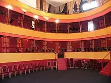 Workshop and store of Arts Theatre (formerly Theatre Royal and Festival Theatre, now Cambridge Buddhist Centre) |
| Barnwell Priory (the Cellarer's Checker) | Cambridge | Augustinian monastery | 13th century | 26 April 1950 | TL4625158974 52°12′35″N 0°08′20″E |
1126103 | 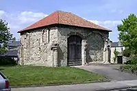 Barnwell Priory (the Cellarer's Checker) |
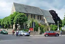
| Church of Our Lady and the English Martyrs | Hills Road/Lensfield Road | Roman Catholic church | 1887–90 | 26 April 1950 | TL4549257744 52°11′55″N 0°07′39″E |
1349061 | |
| Church of St Clement | Bridge Street | Church | Late 12th–early 13th century | 26 April 1950 | TL4481758881 52°12′33″N 0°07′05″E |
1126262 | |
| Church of St Edward, King and Martyr | Peas Hill/St Edward's Passage | Church | Early 13th century | 26 April 1950 | TL4486958386 52°12′17″N 0°07′07″E |
1126076 | |
| Church of St Giles | Castle Street | Church | Early 12th century | 26 April 1950 | TL4460059110 52°12′40″N 0°06′54″E |
1331828 | |
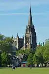
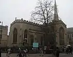
| Church of St Mary the Less (Little St Mary's) | Trumpington Street | Church | 12th century | 26 April 1950 | TL4485557996 52°12′04″N 0°07′05″E |
1051677 | 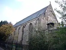 Church of St Mary the Less (Little St Mary's) |
| Church of St Peter | St Peter's Street | Church | Late 11th–early 12th century | 26 April 1950 | TL4453059089 52°12′40″N 0°06′50″E |
1331919 | |
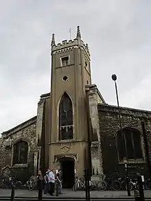
| Church of the Holy Trinity | Market Street | Church | Late 12th century | 26 April 1950 | TL4498458527 52°12′21″N 0°07′13″E |
1331864 | |
| Clare College Memorial Court | Clare College | Courtyard | 1922–33 | 10 May 1962 | TL4430158417 52°12′18″N 0°06′37″E |
1115639 |  Clare College Memorial Court |
| Clare College, Gateway to Clare Hall Piece | Clare College | Gate | Early 18th century | 26 April 1950 | TL4443158397 52°12′18″N 0°06′44″E |
1332170 |  Clare College, Gateway to Clare Hall Piece |
| Cory House | Northampton Street | House | 18th century | 26 April 1950 | TL4459359034 52°12′38″N 0°06′53″E |
1126151 |  Cory House |
| Cripps Building at St John's College | St John's College | Hall of residence | Designed 1962–63 | 31 March 2009 | TL4463658891 52°12′33″N 0°06′55″E |
1393223 |  Cripps Building at St John's College |
| Finella | Queen's Road | House | c.1840 | 2 August 1996 | TL4442258025 52°12′06″N 0°06′43″E |
1268344 | 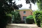 Finella |
| Gonville and Caius College, Lecture Rooms | Gonville and Caius College | University college | 1883 | 2 November 1972 | TL4473058495 52°12′20″N 0°07′00″E |
1332158 | 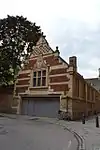 Gonville and Caius College, Lecture Rooms |
| Gonville and Caius College, the north and east ranges of Tree Court and South Wall | Gonville and Caius College | University college | 1870 | 18 May 1967 | TL4482258534 52°12′22″N 0°07′05″E |
1115408 |  Gonville and Caius College, the north and east ranges of Tree Court and South Wall |
| Harvey Court, Gonville and Caius College | Gonville and Caius College | Hall of residence | 1960–62 | 30 March 1993 | TL4432658137 52°12′09″N 0°06′38″E |
1126009 |  Harvey Court, Gonville and Caius College |
| Hobson's Conduit | Lensfield Road/Trumpington Road | Fountain | 1614 | 26 April 1950 | TL4515257638 52°11′52″N 0°07′21″E |
1067788 | |
| Kerbstones to pool in courtyard to west of Hall, Murray Edwards College (formerly New Hall) | Murray Edwards College | Fountain | 1962–66 | 30 March 1993 | TL4412459442 52°12′52″N 0°06′29″E |
1227647 |  Kerbstones to pool in courtyard to west of Hall, Murray Edwards College (formerly New Hall) |
| King's College, Gateway to Queen's Road | King's College | Gate | 1818 | 2 November 1972 | TL4443458234 52°12′12″N 0°06′44″E |
1318911 |  King's College, Gateway to Queen's Road |
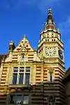
| Lloyds Bank | 1–5 Sidney Street | Bank (financial) | 1891 | 2 November 1972 | TL4506758494 52°12′20″N 0°07′17″E |
1331920 | |
| Magdalene College, Benson Court | Magdalene College | Timber-framed house | 16th century | 2 November 1972 | TL4465358983 52°12′36″N 0°06′56″E |
1332186 | 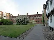 Magdalene College, Benson Court |
| Magdalene College, Mallory Court, north-west range | Magdalene College | University college | 17th century | 2 November 1972 | TL4457958994 52°12′37″N 0°06′52″E |
1332185 |  |
| Merton Hall | Northampton Street | House | 17th century | 26 April 1950 | TL4448258949 52°12′35″N 0°06′47″E |
1331893 | |
| Murray Edwards College (formerly New Hall) | Huntingdon Road | University college | 1962–66 | 30 March 1993 | TL4415559425 52°12′51″N 0°06′31″E |
1331922 |  Murray Edwards College (formerly New Hall) |
| Newnham College, Clough Hall | Newnham College | 1875–1910 | 18 May 1967 | TL4407757862 52°12′01″N 0°06′24″E |
1186757 | 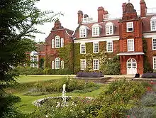 Newnham College, Clough Hall | |
| Newnham College, Kennedy Buildings | Newnham College | University college | 1905 | 18 May 1967 | TL4401757873 52°12′01″N 0°06′21″E |
1125508 | 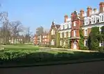 Newnham College, Kennedy Buildings |
| Newnham College, Old Library | Newnham College | Library | 1897 | 18 May 1967 | TL4414557869 52°12′01″N 0°06′28″E |
1332187 | 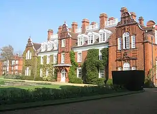 Newnham College, Old Library |
| Newnham College, Peile Hall | Newnham College | 1875–1910 | 18 May 1967 | TL4399357818 52°11′59″N 0°06′20″E |
1186762 |  Newnham College, Peile Hall | |
| Newnham College, Pfeiffer Building | Newnham College | Gate | 1892 | 18 May 1967 | TL4420357802 52°11′59″N 0°06′31″E |
1125506 | 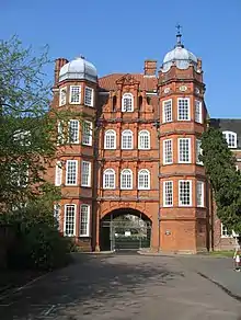 Newnham College, Pfeiffer Building |
| Newnham College, Sidgwick Hall | Newnham College | University college | 1880 | 18 May 1967 | TL4416857833 52°12′00″N 0°06′29″E |
1145889 | 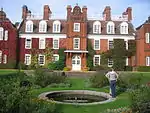 Newnham College, Sidgwick Hall |
| Pembroke College, Library | Pembroke College | Library | 1875–77 | 18 May 1967 | TL4493758041 52°12′06″N 0°07′10″E |
1125510 | 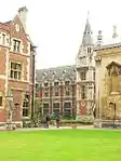 Pembroke College, Library |
| Pembroke College, New Court | Pembroke College | University college | 1883 | 18 May 1967 | TL4500558170 52°12′10″N 0°07′14″E |
1125512 | 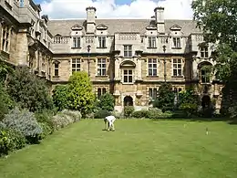 Pembroke College, New Court |
| Schlumberger Gould Research Centre | Cambridge | Research centre | 1985 | 17 February 2017 | TL4233359154 52°12′44″N 0°04′54″E |
1438644 |  Schlumberger Gould Research Centre |
| Shawms | Conduit Head Road | Timber-framed house | 1938 | 2 August 1996 | TL4280659562 52°12′57″N 0°05′20″E |
1268363 | |
| Sidney Sussex College, Cloister Court | Sidney Sussex College | Walk | 1891 | 18 May 1967 | TL4497058735 52°12′28″N 0°07′13″E |
1125496 |  Sidney Sussex College, Cloister Court |
| St John's College, gate to Trinity Piece south-east of the Wilderness | St John's College | Gate | Early/mid-18th century | 2 November 1972 | TL4442058647 52°12′26″N 0°06′44″E |
1125491 |  St John's College, gate to Trinity Piece south-east of the Wilderness |
| The Old House | Church Lane, Trumpington | House | Late 16th century | 26 April 1950 | TL4442354969 52°10′27″N 0°06′38″E |
1111864 |  The Old House |
| Trinity College, Nevile's Gate to Trinity Lane | Trinity College | Gate | c.1610 | 2 November 1972 | TL4470958572 52°12′23″N 0°06′59″E |
1325525 |  Trinity College, Nevile's Gate to Trinity Lane |
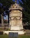
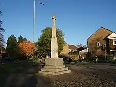
| Trumpington War Memorial | High Street, Trumpington | Cross | 1921 | 12 February 1999 | TL4455455119 52°10′31″N 0°06′45″E |
1245571 | |
| Wanstead House | 2, Hills Road | House | c.1825 | 26 April 1950 | TL4553657679 52°11′53″N 0°07′41″E |
1099114 |  Wanstead House |
| Willow House | Conduit Head Road | House | 1932 | 3 August 1992 | TL4286959393 52°12′51″N 0°05′23″E |
1331936 | |
| 30 and 31 Trinity Street | 30 and 31, Trinity Street | House | 18th century | 26 April 1950 | TL4483158609 52°12′24″N 0°07′05″E |
1126068 |  30 and 31 Trinity Street |
| 1 Northampton Street | 1 Northampton Street, 13 and 14 Magdalene Street | House | 17th century | 26 April 1950 | TL4460959035 52°12′38″N 0°06′54″E |
1331873 |  1 Northampton Street |
| 15, 15a, 15b and 16 Magdalene Street | 15, 15a, 15b and 16, Magdalene Street | House | 17th century | 26 April 1950 | TL4461759027 52°12′38″N 0°06′55″E |
1347915 |  15, 15a, 15b and 16 Magdalene Street |
| 13 Trinity Street | 13, Trinity Street | House | Late 18th century | 26 April 1950 | TL4485158593 52°12′24″N 0°07′06″E |
1126063 |  13 Trinity Street |
| 14 Trinity Street | 14, Trinity Street | House | Late 16th century | 26 April 1950 | TL4485158602 52°12′24″N 0°07′06″E |
1331909 |  14 Trinity Street |
| 31 Trumpington Street | 31, Trumpington Street | House | c.1700 | 26 April 1950 | TL4498657913 52°12′01″N 0°07′12″E |
1077008 | 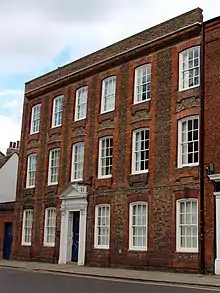 31 Trumpington Street |
.jpg.webp)


Notes
- The date given is the date used by Historic England as significant for the initial building or that of an important part in the structure's description.
- Sometimes known as OSGB36, the grid reference is based on the British national grid reference system used by the Ordnance Survey.
- The "List Entry Number" is a unique number assigned to each listed building and scheduled monument by Historic England.
References
- "Listed buildings". www.cambridge.gov.uk. Cambridge City Council. Retrieved 24 August 2013.
External links
![]() Media related to Grade II* listed buildings in Cambridge at Wikimedia Commons
Media related to Grade II* listed buildings in Cambridge at Wikimedia Commons