Grade II* listed buildings in City of Canterbury
There are over 20,000 Grade II* listed buildings in England. This page is a list of these buildings in the district of City of Canterbury in Kent.
List of buildings
| Name | Location | Type | Completed [note 1] | Date designated | Grid ref.[note 2] Geo-coordinates |
Entry number [note 3] | Image |
|---|---|---|---|---|---|---|---|
| Anne Court, Barham Court | Barham | Apartment | 17th century | 29 September 1952 | TR2098850059 51°12′25″N 1°09′44″E |
1336516 |  |
| Clock Tower, Herne Bay | Herne Bay | Free-standing clock tower | 2 October 1837 | 29 September 1951 | TR1768968411 51°22′23″N 1°07′35″E |
1085006 | |
| The Steward's House, Broome Park Hotel | Barham | Steward's house | c.1778 | 30 January 1967 | TR2203648172 51°11′23″N 1°10′34″E |
1111767 | 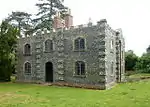 The Steward's House, Broome Park Hotel |
| Higham Park (formerly Highland Court Hospital) | Bekesbourne-with-Patrixbourne | Country house | 18th century | 14 March 1980 | TR1934253763 51°14′27″N 1°08′28″E |
1085542 | |
| Howletts Wild Animal Park | Howletts Zoo Park, Bekesbourne-with-Patrixbourne | House | 1787 | 30 January 1967 | TR1962356736 51°16′03″N 1°08′49″E |
1336480 | |
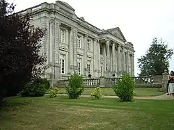
| Charlton Park | Bishopsbourne | House | 16th century with 18th-century frontage | 29 September 1952 | TR1902651770 51°13′23″N 1°08′07″E |
1350018 | 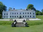 Charlton Park |
| Bridge Place | Bridge | Country house | Late 17th century | 29 September 1952 | TR1812153908 51°14′33″N 1°07′25″E |
1336506 | 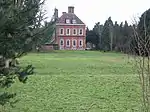 Bridge Place |
| Church of St Peter | Bridge | Church | 12th century, restored 1859–61 | 30 January 1967 | TR1834554112 51°14′40″N 1°07′37″E |
1336512 | 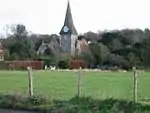 Church of St Peter |
| Mystole Coach House | Mystole House, Chartham | Bell tower | Early 18th century | 30 January 1967 | TR0950553706 51°14′39″N 1°00′01″E |
1100332 | |
| Mystole House, South Mystole and West Wing | Mystole House, Chartham | House | 1980 | 29 September 1952 | TR0952053752 51°14′40″N 1°00′02″E |
1085682 |  Mystole House, South Mystole and West Wing |
| The Deanery | Chartham | House | 17th century | 30 January 1967 | TR1007255087 51°15′22″N 1°00′33″E |
1085676 | |
| Tudor House | Chislet | House | c.1500 | 29 September 1952 | TR2165964039 51°19′56″N 1°10′50″E |
1084381 | |
| The Town Hall and The Crane House, with the stocks outside the Town Hall | Fordwich | Prison | Probably early 15th century | 29 September 1952 | TR1804759814 51°17′44″N 1°07′34″E |
1085670 | 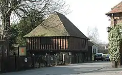 The Town Hall and The Crane House, with the stocks outside the Town Hall |
| Watergate Cottage & Watergate House | Fordwich | House | 1967 | 30 January 1967 | TR1804659780 51°17′43″N 1°07′34″E |
1065708 |  Watergate Cottage & Watergate House |
| Church of the Holy Cross | Hoath | Bell tower | 1842 | 30 January 1967 | TR2030864190 51°20′03″N 1°09′41″E |
1085646 | 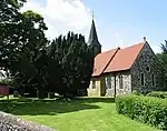 Church of the Holy Cross |
| Shelvingford Farmhouse | Shelvingford, Hoath | House | Late 15th century | 29 May 2015 | TR2114265405 | 1336522 | 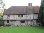 Shelvingford Farmhouse |
| Maypole Thatch | Maypole, Hoath | House | Later-Post c1385 | 14 March 1980 | TR2041464967 51°20′28″N 1°09′48″E |
1343666 | |
| New Place | Ickham and Well | House | 16th century | 29 September 1952 | TR2228757870 51°16′36″N 1°11′09″E |
1085607 | |
| The Old Rectory | Ickham, Ickham and Well | Manor house | 13th century | 29 September 1952 | TR2197658249 51°16′48″N 1°10′53″E |
1373865 |  The Old Rectory |
| Elbridge Farmhouse | Littlebourne | Farmhouse | 15th century | 29 September 1952 | TR2031959591 51°17′34″N 1°09′31″E |
1372874 |  Elbridge Farmhouse |
| Kenfield Hall | Petham | Country house | c.1730 | 29 September 1952 | TR1197252520 51°13′57″N 1°02′06″E |
1336559 | |
| Old Hall | Petham | House | 14th century | 14 March 1980 | TR1276751433 51°13′21″N 1°02′44″E |
1054019 | 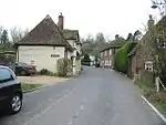 Old Hall |
| Church of St Cosmus and St Damian | Blean, St. Cosmus and St. Damian in the Blean | Church | 13th century | 30 January 1967 | TR1290460666 51°18′19″N 1°03′11″E |
1085522 |  Church of St Cosmus and St Damian |
| Chapel of St John the Baptist, Milton | Thanington, Thanington Without | Chapel | 13th century | 30 January 1967 | TR1204355693 51°15′39″N 1°02′16″E |
1370012 | 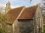 Chapel of St John the Baptist, Milton |
| Church of St Nicholas | Thanington, Thanington Without | Church | Norman | 30 January 1967 | TR1315856782 51°16′13″N 1°03′16″E |
1336614 | 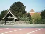 Church of St Nicholas |
| Tonford Manor | Thanington Without | House | 1449 | 29 September 1952 | TR1249357040 51°16′22″N 1°02′42″E |
1045882 |  Tonford Manor |
| Barn at Hardres Court | Hardres Court, Upper Hardres | Aisled barn | Late 15th to early 16th century | 14 March 1980 | TR1529650678 51°12′53″N 1°04′53″E |
1085505 | |
| Handville Green | Anvil Green, Waltham | House | 16th century | 14 March 1980 | TR1089849622 51°12′25″N 1°01′04″E |
1085517 | |
| Westbere House | Westbere | House | c.1800 | 29 September 1952 | TR1925461036 51°18′22″N 1°08′39″E |
1367055 |  Westbere House |
| The Old Stone House [formerly The Post Office] | Wickhambreaux | House | 16th century or earlier | 29 September 1952 | TR2206658658 51°17′02″N 1°10′59″E)] |
1054855 | 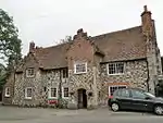 The Old Stone House [formerly The Post Office] |
| Wickham House | Wickhambreaux | Vicarage | 1713 | 30 January 1967 | TR2208858792 51°17′06″N 1°11′00″E |
1085492 |  Wickham House |
| Chapel to St John's Hospital | Canterbury | Chapel | Late 11th/early 12th century | 3 December 1949 | TR1519558337 51°17′01″N 1°05′04″E |
1241057 | |
| Church of All Saints | Whitstable | Church | Perpendicular | 30 March 1951 | TR1173966248 51°21′21″N 1°02′23″E |
1084932 |  Church of All Saints |
| Church of St Alphege with St Margaret | Canterbury | Parish church | Late 12th/13th century | 3 December 1949 | TR1496458018 51°16′51″N 1°04′52″E |
1241460 |  Church of St Alphege with St Margaret |
| Church of St Margaret | Canterbury | Parish church | 12th century | 3 December 1949 | TR1488757741 51°16′42″N 1°04′47″E |
1241922 | 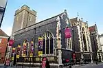 Church of St Margaret |
| Church of St Paul Without the Walls | St Paul's, Canterbury | Church | 13th century | 3 December 1949 | 49°46′01″N 7°33′26″W | 1336814 | 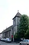 Church of St Paul Without the Walls |
| Church of the Holy Cross | Canterbury | Church | 1381 | 3 December 1949 | TR1459258063 51°16′53″N 1°04′32″E |
1241661 | 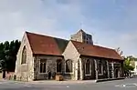 Church of the Holy Cross |
| Cockyns/Cogans Hospital or Cogan House | Canterbury | House | Late 12th century | 3 May 1967 | TR1473357962 51°16′49″N 1°04′39″E |
1116577 | |
| Conquest House | Canterbury | Timber-framed house | Early Norman | 3 December 1949 | TR1499258064 51°16′52″N 1°04′53″E |
1241437 | 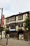 Conquest House |
| County of Kent War Memorial Cross | Canterbury | War memorial | 1921 | 16 May 2017 | TR1525857875 51°16′46″N 51°16′46″E |
1446080 | .jpg.webp) County of Kent War Memorial Cross |
| Gatehouse to St John's Hospital | Canterbury | Gatehouse | 16th century | 3 December 1949 | TR1520958297 51°16′59″N 1°05′05″E |
1260716 | 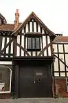 Gatehouse to St John's Hospital |
| House of Agnes Hotel | Canterbury | Timber-framed house | 16th century | 3 December 1949 | TR1444558179 51°16′57″N 1°04′25″E |
1260281 | 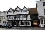 House of Agnes Hotel |
| King's Bridge | Canterbury | Bridge | Medieval | 7 September 1973 | TR1478657930 51°16′48″N 1°04′42″E |
1085029 | 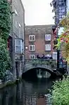 King's Bridge |
| Lullingstone House | Canterbury | House | Early 18th century | 3 December 1949 | TR1474957612 51°16′38″N 1°04′40″E |
1085090 | 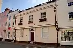 Lullingstone House |
| Manwood's Hospital | Hackington, Canterbury | Almshouse | 1570 | 3 December 1949 | TR1470059134 51°17′27″N 1°04′40″E |
1374126 | 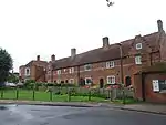 Manwood's Hospital |
| Number 77 (part of the Rose and Crown Inn), Nos 78 & 79, St Dunstans St | Canterbury | House | 16th century | 3 December 1949 | TR1447958155 51°16′56″N 1°04′27″E |
1241876 |  Number 77 (part of the Rose and Crown Inn), Nos 78 & 79, St Dunstans St |
| Old Huguenot Weaver's House | Canterbury | Timber-framed house | 16th century | 3 December 1949 | TR1501358102 51°16′53″N 1°04′54″E |
1241442 | 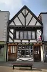 Old Huguenot Weaver's House |
| Queen Elizabeth's Guest Chamber | Canterbury | Inn | Late 16th century | 3 December 1949 | TR1489357817 51°16′44″N 1°04′47″E |
1260873 | 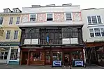 Queen Elizabeth's Guest Chamber |
| Refectory Hall and Kitchen to St John's Hospital | Canterbury | Kitchen | 12th century | 3 December 1949 | TR1515858333 51°17′01″N 1°05′02″E |
1260717 |  Refectory Hall and Kitchen to St John's Hospital |
| St Radigund Hall | St Radigun's, Canterbury | Wealden house | 15th century | 3 December 1949 | TR1506958206 51°16′57″N 1°04′57″E |
1336812 |  St Radigund Hall |
| The Hoystings | Canterbury | House | Early 18th century | 3 December 1949 | TR1525057206 51°16′24″N 1°05′04″E |
1260634 | 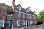 The Hoystings |
| The King's School Shop | Canterbury | Timber-framed house | 16th century | 3 December 1949 | TR1502358122 51°16′54″N 1°04′55″E |
1241614 | 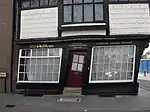 The King's School Shop |
| The Presbytery | Canterbury | House | 18th century | 3 December 1949 | TR1513957759 51°16′42″N 1°05′00″E |
1251907 | 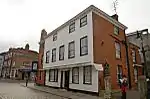 The Presbytery |
| The Roper Gate | Canterbury | Gate | 16th century | 7 September 1973 | TR1434258284 51°17′00″N 1°04′20″E |
1241835 | 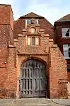 The Roper Gate |
| The Weavers | Canterbury | Jettied house | 1500 | 3 December 1949 | TR1478457943 51°16′48″N 1°04′42″E |
1242339 | 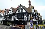 The Weavers |
| Tudor House | Canterbury | House | 18th century | 3 May 1967 | TR1485157961 51°16′49″N 1°04′46″E |
1085169 |  Tudor House |
| Tyler Hill Railway Tunnel, including North and South Portals, under Tyler Hill (former Canterbury and Whitstable Railway) | Tyler Hill, Canterbury | Railway tunnel | 1826–30 | 24 December 2007 | TR1415659825 51°17′50″N 1°04′14″E |
1392354 | 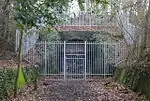 Tyler Hill Railway Tunnel, including North and South Portals, under Tyler Hill (former Canterbury and Whitstable Railway) |
| Underdown House | Eddington, Canterbury | House | 17th century | 29 September 1951 | TR1787866959 51°21′36″N 1°07′41″E |
1084951 | |
| Walpole House, King's School | Canterbury | Archbishops palace | Medieval | 3 December 1949 | TR1500658007 51°16′50″N 1°04′54″E |
1241505 | |
| Westgate House | Canterbury | House | 1750 | 3 December 1949 | TR1452558123 51°16′55″N 1°04′29″E |
1241911 | 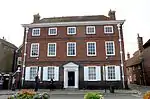 Westgate House |
| Wincheap House | Canterbury | House | 18th century | 3 December 1949 | TR1434457218 51°16′26″N 1°04′18″E |
1258047 |  Wincheap House |
| 17 Cathedral Precincts | Canterbury | House | 18th century | 3 December 1949 | TR1522857950 51°16′48″N 1°05′05″E |
1085076 | |
| Pilgrims Entry or Pentise attached to Number 29, Cathedral Precincts | Canterbury | Cathedral precinct | Medieval | 7 September 1973 | TR1508158043 51°16′51″N 1°04′58″E |
1085079 | |
| 30 Northgate | Canterbury | House | 18th century | 3 May 1967 | TR1529858369 51°17′02″N 1°05′09″E |
1096944 | 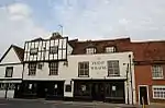 30 Northgate |
| 1 and 2 High Street | Canterbury | Inn | 14th century | 3 May 1967 | TR1494057805 51°16′44″N 1°04′50″E |
1240669 |  1 and 2 High Street |
| 37 Burgate | Canterbury | House | 18th century | 3 December 1949 | TR1499157856 51°16′45″N 1°04′53″E |
1262580 | 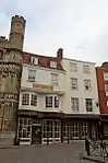 37 Burgate |
| 40 Burgate | Canterbury | House | Late 14th century | 3 December 1949 | TR1499957820 51°16′44″N 1°04′53″E |
1251875 | 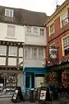 40 Burgate |
| 41 Burgate | Canterbury | Timber-framed house | Late 14th century | 3 December 1949 | TR1500457831 51°16′45″N 1°04′53″E |
1085121 | 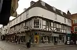 41 Burgate |
| 42 Burgate | Canterbury | Timber-framed house | Late 14th century | 3 December 1949 | TR1500957829 51°16′44″N 1°04′53″E |
1336773 | 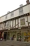 42 Burgate |
| 43 Burgate | Canterbury | Timber-framed house | Late 14th century | 3 December 1949 | TR1501557827 51°16′44″N 1°04′54″E |
1251891 | 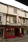 43 Burgate |
| 62 Burgate | Canterbury | House | Early 18th century | 3 December 1949 | TR1517157744 51°16′41″N 1°05′02″E |
1336774 | 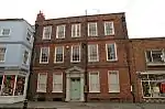 62 Burgate |
| 3 Best Lane | Canterbury | House | 18th century | 3 May 1967 | TR1486557980 51°16′50″N 1°04′46″E |
1085167 |  3 Best Lane |
| 4 Best Lane | Canterbury | House | 18th century | 3 May 1967 | TR1486357976 51°16′49″N 1°04′46″E |
1336756 |  4 Best Lane |
| 2 Castle Street | Canterbury | Town house | 18th century | 3 May 1967 | TR1476457626 51°16′38″N 1°04′40″E |
1085088 | 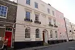 2 Castle Street |
| 68 and 68a Castle Street | Canterbury | House | Early 18th century | 3 May 1967 | TR1470457600 51°16′37″N 1°04′37″E |
1085101 |  68 and 68a Castle Street |
| 69 Castle Street | Canterbury | House | 16th century | 3 May 1967 | TR1471457608 51°16′38″N 1°04′38″E |
1252148 | 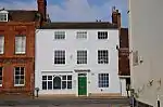 69 Castle Street |
| 1–8 Mercery Lane | Canterbury | House | 14th century | 3 December 1949 | TR1495757830 51°16′45″N 1°04′51″E |
1097028 |  1–8 Mercery Lane |
| 42–45 Ivy Lane | Canterbury | Wealden house | 15th century | 3 December 1949 | TR1538357600 51°16′37″N 1°05′12″E |
1260829 | 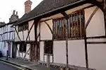 42–45 Ivy Lane |
| 8 Palace Street | Canterbury | Timber-framed house | Medieval | 3 December 1949 | TR1496157993 51°16′50″N 1°04′51″E |
1241459 | 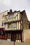 8 Palace Street |
| 41–45 Palace Street | Canterbury | House | Medieval | 3 May 1967 | TR1501458039 51°16′51″N 1°04′54″E |
1241616 | 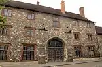 41–45 Palace Street |
| 16 Watling Street | Canterbury | House | Early 18th century | 3 December 1949 | TR1485857592 51°16′37″N 1°04′45″E |
1242830 | 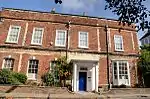 16 Watling Street |


Notes
- The date given is the date used by Historic England as significant for the initial building or that of an important part in the structure's description.
- Sometimes known as OSGB36, the grid reference is based on the British national grid reference system used by the Ordnance Survey.
- The "List Entry Number" is a unique number assigned to each listed building and scheduled monument by Historic England.
External links
![]() Media related to Grade II* listed buildings in Canterbury at Wikimedia Commons
Media related to Grade II* listed buildings in Canterbury at Wikimedia Commons
This article is issued from Wikipedia. The text is licensed under Creative Commons - Attribution - Sharealike. Additional terms may apply for the media files.