Grade II* listed buildings in Bradford
There are over 20,000 Grade II* listed buildings in England. This page is a list of these buildings in the metropolitan borough of Bradford in West Yorkshire.
List of buildings
| Name | Location | Type | Completed [note 1] | Date designated | Grid ref.[note 2] Geo-coordinates |
Entry number [note 3] | Image |
|---|---|---|---|---|---|---|---|
| Friends' Meeting House | Addingham | Friends' meeting house | 1689 | 10 September 1954 | SE0761051790 53°57′44″N 1°53′08″W |
1199556 | |
| Baildon Hall | Baildon | Cross-wing house | Late 15th century | 25 May 1966 | SE1553039347 53°51′00″N 1°45′56″W |
1199151 |  |
| Harden Hall | Harden | House | Early–mid-17th century | 9 August 1966 | SE0866337846 53°50′12″N 1°52′11″W |
1134140 |  Harden Hall |
| Church of St Michael and All Angels | Haworth, Cross Roads and Stanbury | Church | 16th century | 23 February 1955 | SE0298737215 53°49′52″N 1°57′22″W |
1283403 |  Church of St Michael and All Angels |
| Ponden Hall | Scar Top, Haworth, Cross Roads and Stanbury | Farmhouse | 1801 | 23 February 1955 | SD9867737266 53°49′54″N 2°01′18″W |
1313937 | |
| Church of St Margaret | Ilkley | Parish church | 1878–79 | 20 May 1976 | SE1149047251 53°55′17″N 1°49′36″W |
1200770 |  Church of St Margaret |
| Low Hall | Ilkley | House | 17th century | 18 July 1949 | SE1150448524 53°55′58″N 1°49′35″W |
1314214 |  Low Hall |
| Parish Church of All Saints | Ilkley | Parish church | 13th century | 18 July 1949 | SE1164547825 53°55′35″N 1°49′27″W |
1133506 |  Parish Church of All Saints |
| Mill buildings at Low Mills | Keighley | Mill | Late 18th century | 12 February 1979 | SE0655241165 53°52′00″N 1°54′07″W |
1200162 | |
| Menston Old Hall (Fairfax Hall) | Menston | Detached house | 17th century | 18 July 1949 | SE1673244023 53°53′32″N 1°44′49″W |
1314210 | |
| Barn, 15 metres south of Holden Gate Farmhouse | Silsden | Barn | 1641 | 27 September 1965 | SE0661544200 53°53′38″N 1°54′03″W |
1267373 | |
| Waterloo Mill and attached engine house | Silsden | Mill | 1867–84 | 25 January 1985 | SE0431646149 53°54′41″N 1°56′09″W |
1266636 |  Waterloo Mill and attached engine house |
| 18–26 Bradley Road | Silsden | House | 1682 | 27 September 1965 | SE0401246651 53°54′58″N 1°56′25″W |
1223261 |  18–26 Bradley Road |
| Church of All Saints | Little Horton, Trident | Church | 1864 | 9 August 1983 | SE1569932050 53°47′04″N 1°45′48″W |
1207967 | 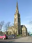 Church of All Saints |
| 30 and 31 Little Horton Green (Little Horton Hall) | Little Horton, Trident | House | Mid- to late 17th century | 4 September 1952 | SE1558132116 53°47′06″N 1°45′54″W |
1133011 | 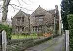 30 and 31 Little Horton Green (Little Horton Hall) |
| 54 Little Horton Lane | Trident | Villa | Circa 1850–60 | 9 August 1983 | SE1598932553 53°47′21″N 1°45′32″W |
1133017 | |
| Bolton Old Hall | Gaisby, Wrose | House | 1627 | 4 September 1952 | SE1663336285 53°49′21″N 1°44′56″W |
1314357 |  Bolton Old Hall |
| Bolton Old Hall Cottage | Gaisby, Wrose | Timber-framed house | Early to mid-17th century | 18 July 1975 | SE1663836294 53°49′22″N 1°44′55″W |
1115592 | |
| Aldersley Farmhouse | Allerton Upper Green | Farmhouse | Latter part of 17th century | 4 September 1952 | SE1030333759 53°48′00″N 1°50′42″W |
1133647 |  Aldersley Farmhouse |
| Barn immediately east of New Close Farmhouse | Nab Wood | Aisled barn | 17th century | 7 May 1976 | SE1235036946 53°49′43″N 1°48′50″W |
1133576 | |
| Behrens Warehouse | Little Germany | Warehouse | 1873 | 9 August 1983 | SE1695433118 53°47′39″N 1°44′39″W |
1314395 |  Behrens Warehouse |
| Bradford Reform Synagogue | Manningham | Synagogue | 1880–81 | 6 December 1989 | SE1574833882 53°48′04″N 1°45′45″W |
1227613 | |
| Building immediately to north of present Home Farmhouse at Esholt Hall Home Farm | Esholt | Farmhouse | 1691 | 4 September 1952 | SE1905639612 53°51′09″N 1°42′42″W |
1133156 | |
| Church of All Saints | Bingley | Church | Late 15th century | 9 August 1966 | SE1053939474 53°51′05″N 1°50′29″W |
1200095 | 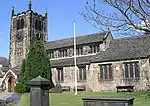 Church of All Saints |
| Church of St Clement | Barkerend | Church | 1892–94 | 9 June 1981 | SE1779133549 53°47′53″N 1°43′53″W |
1184649 |  Church of St Clement |
| Church of St Cuthbert (Roman Catholic) | Bradford | Roman Catholic church | 1890–91 | 2 September 1998 | SE1451135117 53°48′44″N 1°46′52″W |
1376263 |  Church of St Cuthbert (Roman Catholic) |
| Church of St John | Bierley | Chapel | 1766 | 4 September 1952 | SE1773730496 53°46′14″N 1°43′57″W |
1314522 | 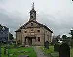 Church of St John |
| Dean House | Allerton Lanes | House | 1605 | 4 September 1952 | SE1116533695 53°47′58″N 1°49′55″W |
1133313 | 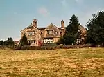 Dean House |
| Devere House | Little Germany | Warehouse | 1871 | 9 August 1983 | SE1678633094 53°47′38″N 1°44′48″W |
1133650 |  Devere House |
| Esholt Hall with terrace and adjoining conservatory | Esholt Estate | Country house | 1706–07 | 4 September 1952 | SE1885839670 53°51′11″N 1°42′53″W |
1133190 | |
| Feversham Street First School | Bradford | School | 1873 | 9 August 1983 | SE1714532926 53°47′33″N 1°44′28″W |
1133162 |  Feversham Street First School |
| Frizingley Hall | Frizinghall | House | c.1730–50 | 9 August 1983 | SE1523235817 53°49′06″N 1°46′12″W |
1133166 | |
| Frizley Old Hall | Frizinghall | House | 1727 | 9 August 1983 | SE1524535824 53°49′07″N 1°46′12″W |
1119622 | |
| Gate piers at entrance to Tong Hall drive | Tong | Gate pier | 18th century | 4 September 1952 | SE2186730510 53°46′14″N 1°40′11″W |
1133659 |  Gate piers at entrance to Tong Hall drive |
| Gawthorpe Hall including south wing | Bingley | Manor house | Mid-17th century | 9 August 1966 | SE1094340134 53°51′26″N 1°50′06″W |
1199532 | |
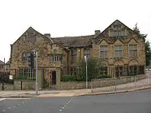
| Idle Young Men's Christian Association Youth Community Centre | Idle | Sunday school | 1630 | 4 September 1952 | SE1767137941 53°50′15″N 1°43′59″W |
1133673 |  Idle Young Men's Christian Association Youth Community Centre |
| Ireland Bridge | Bingley | Road bridge | 1686 | 9 August 1966 | SE1052439354 53°51′01″N 1°50′29″W |
1133377 | |
| Law Russell Warehouse | Little Germany | Warehouse | 1873 | 9 August 1983 | SE1676033137 53°47′39″N 1°44′49″W |
1133652 |  Law Russell Warehouse |
| Three Rise Locks with overflow channel | Leeds and Liverpool Canal, Bingley | Canal locks | c.1773 | 18 October 1985 | SE1072639477 53°51′05″N 1°50′18″W |
1133361 |  Three Rise Locks with overflow channel |
| Two Rise Locks with overflow channel, Dowley Gap | Leeds and Liverpool Canal | Canal locks | c.1773 | 18 October 1985 | SE1196738319 53°50′28″N 1°49′11″W |
1133359 |  Two Rise Locks with overflow channel, Dowley Gap |
| Leventhorpe Hall | Lower Grange | House | Late 17th century | 4 September 1952 | SE1171732800 53°47′29″N 1°49′25″W |
1133692 |  Leventhorpe Hall |
| Lower Bailey Fold Farmhouse | Allerton | Farmhouse | Late 17th century | 4 September 1952 | SE1099233969 53°48′07″N 1°50′05″W |
1314364 |  Lower Bailey Fold Farmhouse |
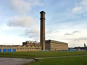
| Manningham Mills | Manningham | Factory | 1873 | 14 June 1963 | SE1445434910 53°48′37″N 1°46′55″W |
1314426 | |
| Midland Bank | Bradford | Bank (financial) | 1858 | 9 August 1983 | SE1634533210 53°47′42″N 1°45′12″W |
1133211 | 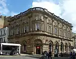 Midland Bank |
| Newhall West Bowling Golf Club | Newhall | House | Late 17th century | 4 September 1952 | SE1703530254 53°46′06″N 1°44′35″W |
1314521 | |
| Number 74 with front garden wall and railings | Thornton | House | 1802 | 4 September 1952 | SE1006732756 53°47′28″N 1°50′55″W |
1132988 |  Number 74 with front garden wall and railings |
| Numbers 3 to 11 (Esholt Old Hall) and adjoining barn | Esholt | House | Late 16th century | 4 September 1952 | SE1820240170 53°51′27″N 1°43′29″W |
1133252 |  Numbers 3 to 11 (Esholt Old Hall) and adjoining barn |
| Paper Hall | Bradford | House | 1643 | 4 September 1952 | SE1691333425 53°47′49″N 1°44′41″W |
1314310 | |
| Royds Hall | Low Moor | Cross-wing house | 1656 | 4 September 1952 | SE1435628230 53°45′01″N 1°47′02″W |
1132910 | |
| Main L-shaped block of stable, coach house and barn enclosing the court to north of the hall outbuildings at Royds Hall | Low Moor | Barn | 1663 | 4 September 1952 | SE1434128266 53°45′02″N 1°47′02″W |
1291670 | |
| Royds Hall Farmhouse | Heaton | Farmhouse | Late 17th century | 4 September 1952 | SE1366936069 53°49′15″N 1°47′38″W |
1133739 | |
| Ryecroft Hall | Holme Shay | House | Mid-17th century | 4 September 1952 | SE2012230575 53°46′16″N 1°41′46″W |
1068660 | |
| Ryshworth Hall | Crossflatts | House | Late 16th century | 9 August 1966 | SE1007740806 53°51′48″N 1°50′54″W |
1133397 | |
| Saltaire Mills – main block including sheds | Saltaire | Mill | 1851–53 | 22 November 1966 | SE1408238039 53°50′18″N 1°47′15″W |
1133523 | 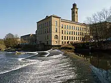 Saltaire Mills – main block including sheds |
| Saltaire Mills – the entrance block | Saltaire | Mill | 1851–53 | 7 March 1985 | SE1397638092 53°50′20″N 1°47′21″W |
1300744 |  Saltaire Mills – the entrance block |
| Saltaire School including wall, gate piers and sculpted lions to front area, and gate to south side | Saltaire | Gate | 1869 | 22 November 1966 | SE1388737896 53°50′14″N 1°47′26″W |
1300666 |  Saltaire School including wall, gate piers and sculpted lions to front area, and gate to south side |
| St George's Hall | Bradford | Meeting hall | 1851–53 | 14 June 1963 | SE1650332941 53°47′33″N 1°45′03″W |
1338589 | |
| Stable Court and Home Farmhouse at Tong Hall | Tong | Farmhouse | Early to mid-18th century | 9 August 1983 | SE2174830706 53°46′20″N 1°40′17″W |
1133658 | |
| The National Westminster Bank | Bradford | Bank (financial) | 1868 | 9 August 1983 | SE1637533155 53°47′40″N 1°45′10″W |
1133063 |  The National Westminster Bank |
| The Old Manor House | Wyke | Manor house | 17th/18th century | 4 September 1952 | SE1523525988 53°43′48″N 1°46′14″W |
1133000 |  The Old Manor House |
| Thornton Hall | Thornton | House | Late 17th century | 4 September 1952 | SE1056332633 53°47′24″N 1°50′28″W |
1220076 | |
| Victoria Hall Including wall, gate piers and sculpted lions to front area, and railings to rear | Saltaire | Institute | 1867–71 | 22 November 1966 | SE1397137883 53°50′13″N 1°47′21″W |
1314205 |  Victoria Hall Including wall, gate piers and sculpted lions to front area, and railings to rear |
| West Scholes House and Cottage | Yews Green | House | Late 17th century | 4 September 1952 | SE0990531428 53°46′45″N 1°51′04″W |
1314162 |  West Scholes House and Cottage |
| Woodside Cottage and Woodside Farmhouse | Wyke | Farmhouse | Late 17th century | 4 September 1952 | SE1468627350 53°44′32″N 1°46′44″W |
1133094 | |
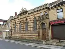
| 439–443 Shetcliffe Lane | Bierley | House | 1625 | 4 September 1952 | SE1780629496 53°45′41″N 1°43′53″W |
1219429 | 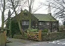 439–443 Shetcliffe Lane |
| 7–10 Chapel Fold | Wibsey | House | c.1635 | 4 September 1952 | SE1472430307 53°46′08″N 1°46′41″W |
1133238 | |
| 670 and 670a Great Horton Road | Great Horton, Bradford | House | 1746 | 4 September 1952 | SE1417431558 53°46′49″N 1°47′11″W |
1133138 |  670 and 670a Great Horton Road |
| Keighley War Memorial | Keighley, Bradford | War memorial | 1924 | 4 December 1986 | SE0607741300 53°52′04″N 1°54′33″W |
1313949 | 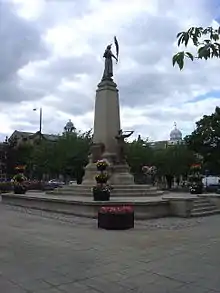 Keighley War Memorial |
%252C_Addingham_-_geograph.org.uk_-_675716.jpg.webp)


See also
Notes
- The date given is the date used by Historic England as significant for the initial building or that of an important part in the structure's description.
- Sometimes known as OSGB36, the grid reference is based on the British national grid reference system used by the Ordnance Survey.
- The "List Entry Number" is a unique number assigned to each listed building and scheduled monument by Historic England.
External links
This article is issued from Wikipedia. The text is licensed under Creative Commons - Attribution - Sharealike. Additional terms may apply for the media files.