Grade II* listed buildings in Bedfordshire
Buildings
Bedford
| Name | Location | Type | Completed [note 1] | Date designated | Grid ref.[note 2] Geo-coordinates |
Entry number [note 3] | Image |
|---|---|---|---|---|---|---|---|
| Bletsoe Castle | Bletsoe | Country house | Late 16th century | 7 May 1952 | TL0248958411 52°12′52″N 0°30′05″W |
1114219 |  |
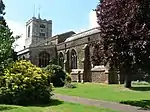
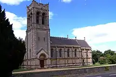
| Church of St Mary the Virgin | Bletsoe | Parish church | Probably late 13th century | 13 July 1964 | TL0234158330 52°12′49″N 0°30′13″W |
1158715 |  Church of St Mary the Virgin |
| Church of St Dunsten | Bolnhurst, Bolnhurst and Keysoe | Parish church | 13th century | 13 July 1964 | TL0807658689 52°12′57″N 0°25′10″W |
1114777 | 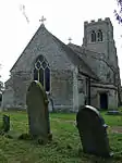 Church of St Dunsten |
| Bromham Hall | Bromham Park, Bromham | House | Early 17th century | 7 May 1952 | TL0168651226 52°09′00″N 0°30′55″W |
1158818 | |
| Howard's House | Cardington | House | 18th century | 7 May 1952 | TL0864047985 52°07′10″N 0°24′53″W |
1114147 | 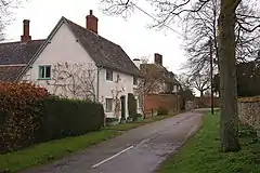 Howard's House |
| Low Farmhouse | Colmworth | Farmhouse | Early 17th century or earlier | 18 August 1983 | TL1008856680 52°11′51″N 0°23′27″W |
1114876 | 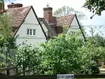 Low Farmhouse |
| Cardington Number 1 Shed at RAF Cardington | Eastcotts | Airship hangar | 1916–17 | 29 January 1982 | TL0807946833 52°06′33″N 0°25′24″W |
1114165 | 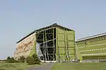 Cardington Number 1 Shed at RAF Cardington |
| Cardington Number 2 Shed at RAF Cardington | Eastcotts | Airship hangar | 1928 | 29 January 1982 | TL0818346760 52°06′31″N 0°25′18″W |
1136810 | 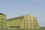 Cardington Number 2 Shed at RAF Cardington |
| Manor Farmhouse | Cotton End, Eastcotts | Farmhouse | Late 16th century | 17 May 1984 | TL0847445585 52°05′53″N 0°25′04″W |
1114166 | |
| Bunyan's Mead | Elstow | House | 16th century | 13 July 1964 | TL0498647531 52°06′58″N 0°28′05″W |
1136945 | 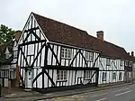 Bunyan's Mead |
| Moot Hall | Elstow | Moot hall | c.1500 | 13 July 1964 | TL0492947518 52°06′58″N 0°28′08″W |
1136906 | 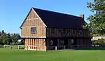 Moot Hall |
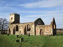
| Parish Church of All Saints | Great Barford | Parish church | 15th century | 13 July 1964 | TL1339851706 52°09′07″N 0°20′38″W |
1137682 | 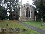 Parish Church of All Saints |
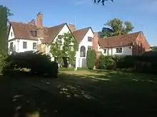
| The Old Manor | Harrold | House | Late 16th or early 17th century | 13 July 1964 | SP9532056821 52°12′05″N 0°36′24″W |
1159476 | |
| Box End House | Kempston Rural | House | 17th or early 18th century | 8 September 1977 | TL0106648556 52°07′34″N 0°31′30″W |
1159567 | |
| Church of All Saints | Souldrop, Knotting and Souldrop | Church | Late 13th century | 13 July 1964 | SP9852361543 52°14′36″N 0°33′30″W |
1159751 | 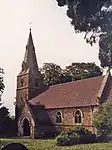 Church of All Saints |
| Parish Church of Saint Denys | Little Barford | Parish church | Late 12th century Norman | 13 July 1964 | TL1775156953 52°11′54″N 0°16′43″W |
1114892 | |
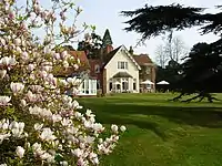
| Melchbourne House | Melchbourne, Melchbourne and Yielden | Country house | 1741 | 13 July 1964 | TL0301465313 52°16′35″N 0°29′30″W |
1114819 | 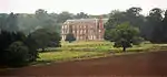 Melchbourne House |
| Oakley House | Oakley | House | c.1795 | 7 May 1952 | TL0046053229 52°10′05″N 0°31′57″W |
1321524 | |
| Harrold Bridge | Odell | Bridge | Mid-14th century | 13 July 1964 | SP9555756542 52°11′56″N 0°36′12″W |
1321535 | 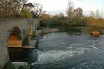 Harrold Bridge |
| The Old Rectory | Pertenhall | House | Late 18th century | 7 May 1952 | TL0847265416 52°16′34″N 0°24′42″W |
1114828 | |
| Garden entrance gates, Hinwick Hall | Hinwick, Podington | Gate | 18th century | 13 July 1964 | SP9348562336 52°15′05″N 0°37′55″W |
1114353 |  Garden entrance gates, Hinwick Hall |
| Hinwick Hall | Hinwick, Podington | Country house | 16th century | 7 May 1952 | SP9345462360 52°15′05″N 0°37′57″W |
1310545 | 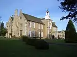 Hinwick Hall |
| Congregational Chapel | Roxton | Chapel | 1808 | 13 July 1964 | TL1518654442 52°10′34″N 0°19′01″W |
1146376 | 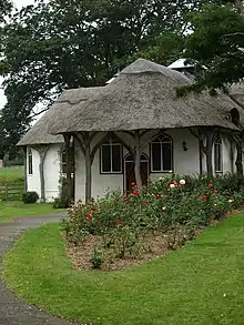 Congregational Chapel |
| Parish Church of Saint Mary Magdalen | Roxton | Parish church | 14th century | 13 July 1964 | TL1534554520 52°10′37″N 0°18′52″W |
1114927 | 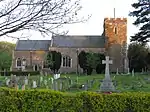 Parish Church of Saint Mary Magdalen |
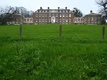
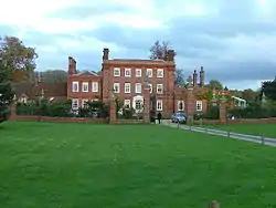
| Colworth House | Colworth Estate, Sharnbrook | Country house | 1714–20 | 7 May 1952 | SP9810060108 52°13′50″N 0°33′54″W |
1160878 | |
| Basmead Manor Farmhouse | Staploe | Farmhouse | 1973–74 | 7 May 1952 | TL1396861195 52°14′14″N 0°19′57″W |
1321617 | |
| Stevington Windmill | Stevington | Post mill | 1770 | 7 May 1952 | SP9919452760 52°09′51″N 0°33′04″W |
1310161 | 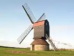 Stevington Windmill |
| Village Cross | Stevington | Village cross | 14th century | 13 July 1964 | SP9894553247 52°10′07″N 0°33′17″W |
1310180 |  Village Cross |
| Churchyard cross near south door of church | Thurleigh | Cross | 15th century | 18 August 1983 | TL0514158450 52°12′51″N 0°27′45″W |
1114123 | |
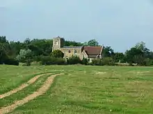
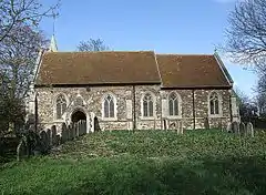
| Parish Church of Saint Peter | Thurleigh | Parish church | Norman | 13 July 1964 | TL0513558466 52°12′52″N 0°27′45″W |
1311731 | 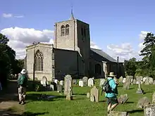 Parish Church of Saint Peter |
| Parish Church of All Saints | Wilshamstead | Parish church | 14th century | 13 July 1964 | TL0626743486 52°04′46″N 0°27′03″W |
1321582 | _-_geograph.org.uk_-_136209.jpg.webp) Parish Church of All Saints |
| Wootton House | Wootton | Country house | Late 17th century | 7 May 1952 | TL0023845046 52°05′41″N 0°32′18″W |
1249255 | |
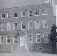
| Bedford Modern School | Bedford | School | 1831–34 | 6 June 1952 | TL0489649763 52°08′10″N 0°28′08″W |
1138232 | |
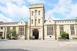
| Bedford School Chapel | Bedford | School | 1907–08 | 14 May 1971 | TL0533650508 52°08′34″N 0°27′44″W |
1321037 | 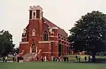 Bedford School Chapel |
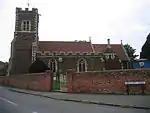
| Church of St Mary the Virgin | Goldington | Church | 13th century | 6 June 1952 | TL0762751011 52°08′49″N 0°25′43″W |
1321043 | 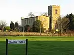 Church of St Mary the Virgin |
| House on north side of St Mary's Square | Bedford | House | c.1707 | 6 June 1952 | TL0508749401 52°07′59″N 0°27′58″W |
1129024 |  House on north side of St Mary's Square |
| North-west block of Bedford Modern School | Bedford | School | 1831–34 | 7 November 1969 | TL0484749798 52°08′12″N 0°28′10″W |
1129010 | |
| St John's Hospital | Bedford | Hospital | 13th century | 14 May 1971 | TL0517049228 52°07′53″N 0°27′54″W |
1321010 | |
| St Mary's House | Bedford | House | c.1707 | 6 June 1952 | TL0524949368 52°07′57″N 0°27′50″W |
1128998 | 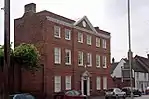 St Mary's House |
| The Public Library | Bedford | Public library | 1834 | 6 June 1952 | TL0494649757 52°08′10″N 0°28′05″W |
1129009 | 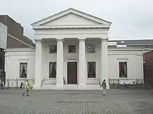 The Public Library |
| The Swan Hotel | Bedford | Hotel | 6 June 1952 | TL0513749631 52°08′06″N 0°27′55″W |
1311924 |  The Swan Hotel | |
| Bedfordshire and Hertfordshire Regimental War Memorial | Kempston | War memorial | 1921 | 17 May 1984 | TL0393148470 52°07′29″N 0°29′00″W |
1114178 |  Bedfordshire and Hertfordshire Regimental War Memorial |
Central Bedfordshire
| Name | Location | Type | Completed [note 1] | Date designated | Grid ref.[note 2] Geo-coordinates |
Entry number [note 3] | Image |
|---|---|---|---|---|---|---|---|
| Avenue House | Ampthill | House | 1775 | 17 July 1951 | TL0355238180 52°01′57″N 0°29′31″W |
1114436 | |
| Dynevor House | Ampthill | Country house | 1725 | 17 July 1951 | TL0368438229 52°01′58″N 0°29′24″W |
1137916 | |
| Ampthill Park House | Ampthill | Country house | 1694 | 17 July 1951 | TL0267039058 52°02′26″N 0°30′16″W |
1137595 | |
| 37 Church Street | Ampthill | House | Early 18th century | 17 July 1951 | TL0364438178 52°01′56″N 0°29′26″W |
1321441 | |
| Aspley House | Aspley Guise | Country house | Pre-1749 | 22 October 1952 | SP9436836094 52°00′55″N 0°37′35″W |
1113948 | |
| Church of St Botolph | Aspley Guise | Parish church | Medieval | 23 January 1961 | SP9424936248 52°01′00″N 0°37′41″W |
1312070 | 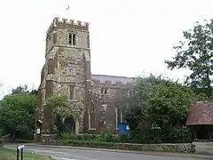 Church of St Botolph |
| Guise House | Aspley Guise | Country house | Early 18th century | 23 January 1961 | SP9428636077 52°00′54″N 0°37′39″W |
1113952 | |
| The Old House | Aspley Guise | House | Early 19th century | 22 October 1952 | SP9440036218 52°00′59″N 0°37′33″W |
1113954 | |
| Church of Saint Michael | Aspley Heath | Parish church | 1868 | 1 March 1972 | SP9285835343 52°00′32″N 0°38′55″W |
1312016 |  Church of Saint Michael |
| Church of Saint Guthlac | Astwick | Parish church | 15th century | 31 October 1966 | TL2134938566 52°01′56″N 0°13′57″W |
1113827 |  Church of Saint Guthlac |
| Church of St Andrew | Biggleswade | Parish church | 14th century | 20 May 1952 | TL1880144602 52°05′13″N 0°16′03″W |
1321424 | |
| Church of All Saints | Caddington | Church | Late 12th century | 3 February 1967 | TL0639819847 51°52′01″N 0°27′22″W |
1321349 | 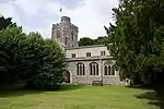 Church of All Saints |
| Campton Manor | Campton, Campton and Chicksands | House | 18th century | 16 January 1952 | TL1290537988 52°01′44″N 0°21′21″W |
1137564 | |
| Orangery approximately 100 metres north-east of Chicksands Priory | Chicksands, Campton and Chicksands | Orangery | c.1800 | 11 October 1973 | TL1217939414 52°02′30″N 0°21′57″W |
1113727 | |
| Church of All Saints | Campton, Campton and Chicksands | Parish church | Late 13th century | 31 October 1966 | TL1299138069 52°01′46″N 0°21′16″W |
1113722 | |
| Church of All Saints | Clifton | Parish church | Early 14th century | 31 October 1966 | TL1658939249 52°02′22″N 0°18′06″W |
1321771 | 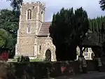 Church of All Saints |
| Church of St Mary the Virgin | Clophill | Church | 14th and 15th century | 23 January 1961 | TL0918938852 52°02′14″N 0°24′34″W |
1113735 | |
| Chew's House | Dunstable | House | c.1715 | 25 October 1951 | TL0213221654 51°53′03″N 0°31′03″W |
1114595 | |
| Marshe Almshouses | Dunstable | Almshouse | c.1743 | 25 October 1951 | TL0218821986 51°53′13″N 0°31′00″W |
1114583 | .jpg.webp) Marshe Almshouses |
| Priory House (Council Offices) | Dunstable | House | 18th century | 25 October 1951 | TL0198721774 51°53′07″N 0°31′11″W |
1114593 | |
| 13 High Street North | Dunstable | Gatehouse | Early 17th century | 4 March 1976 | TL0182821903 51°53′11″N 0°31′19″W |
1114592 | |
| Church of St Mary | Dunton | Church | 14th and 15th century | 31 October 1966 | TL2373944224 52°04′57″N 0°11′44″W |
1114060 | 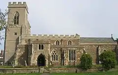 Church of St Mary |
| Doolittle Mill | Eaton Bray | House | 18th century | 26 September 1980 | SP9901320179 51°52′17″N 0°33′48″W |
1321286 | 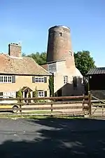 Doolittle Mill |
| Church of St Michael | Eggington | Church | Early 14th century | 3 February 1967 | SP9567925171 51°55′01″N 0°36′37″W |
1158463 |  Church of St Michael |
| Eggington House | Eggington | House | c.1696 | 29 April 1952 | SP9604925356 51°55′06″N 0°36′17″W |
1114682 | |
| Church of Saint John the Baptist | Church End, Eversholt | Parish church | 12th century | 23 January 1961 | SP9829632505 51°58′56″N 0°34′13″W |
1138155 | 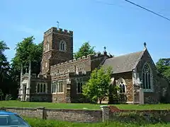 Church of Saint John the Baptist |
| Tyrells End Farmhouse | Tyrells End, Eversholt | House | 15th century | 16 March 1987 | SP9821032911 51°59′10″N 0°34′17″W |
1311955 | |
| Flitwick Manor | Flitwick | House | Earlier 17th century | 22 October 1952 | TL0291534173 51°59′47″N 0°30′09″W |
1137690 | |
| Parish Church of Saint Giles | Upper Gravenhurst, Gravenhurst | Parish church | 12th century | 23 January 1961 | TL1130535987 52°00′40″N 0°22′47″W |
1113746 |  Parish Church of Saint Giles |
| Church of Saint Michael and All Angels | Great Billington | Church | 13th century | 3 February 1967 | SP9404522557 51°53′37″N 0°38′05″W |
1311613 | 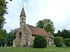 Church of Saint Michael and All Angels |
| Harlington Manor | Harlington | House | Late 14th century | 22 October 1952 | TL0365330451 51°57′46″N 0°29′34″W |
1137774 | |
| Church of Saint Mary the Virgin | Church End, Haynes | Parish church | 14th century | 23 January 1961 | TL0810941190 52°03′31″N 0°25′28″W |
1311867 |  Church of Saint Mary the Virgin |
| Heath Manor | Heath and Reach | Manor house | Late 16th or early 17th century | 29 April 1952 | SP9252627698 51°56′24″N 0°39′20″W |
1114690 | |
| Henlow Grange | Henlow | Country house | Mid-18th century | 16 January 1952 | TL1838938381 52°01′52″N 0°16′32″W |
1113835 | |
| Church of Saint Nicholas | Church End, Hockliffe | Church | 14th century | 3 February 1967 | SP9660826968 51°55′58″N 0°35′47″W |
1114693 | 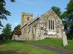 Church of Saint Nicholas |
| 17th-century range of outbuildings to north-west of Houghton Hall | Houghton Regis | Outbuilding | 17th century | 26 September 1980 | TL0217023710 51°54′09″N 0°30′59″W |
1114706 | |
| Houghton Hall | Houghton Regis | House | Late 17th century | 29 April 1952 | TL0219723695 51°54′09″N 0°30′58″W |
1321335 | 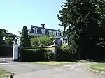 Houghton Hall |
| Crawley House | Crawley Park, Husborne Crawley | Country house | 1777–78 | 22 October 1952 | SP9533036002 52°00′51″N 0°36′44″W |
1321680 | |
| Parish Church of St James | Husborne Crawley | Parish church | 13th century | 23 January 1961 | SP9556536227 52°00′58″N 0°36′32″W |
1321642 |  Parish Church of St James |
| Hyde Mill (including attached granary and store) | Hyde | Corn mill | Late 19th century | 22 June 1998 | TL1324916995 51°50′24″N 0°21′27″W |
1119785 | 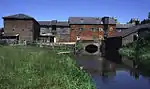 Hyde Mill (including attached granary and store) |
| Luton Hoo Stables, including frontage range and rear courtyard buildings, incorporating stablemaster's house | Luton Hoo Estate, Hyde | House | Early 19th century | 3 February 1967 | TL1046218212 51°51′06″N 0°23′52″W |
1114713 | |
| The Hyde | East Hyde Park, Hyde | House | 18th century | 3 February 1967 | TL1356017649 51°50′45″N 0°21′10″W |
1158916 | |
| Lynch House | Kensworth Lynch, Kensworth | House | 18th century | 3 February 1967 | TL0441518155 51°51′08″N 0°29′08″W |
1114724 | 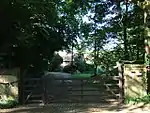 Lynch House |
| Library at the Cedars School | Leighton Buzzard | Clergy house | Early 18th century | 27 May 1954 | SP9184024962 51°54′56″N 0°39′58″W |
1321402 | |
| Market Cross | Leighton Buzzard | Market cross | 15th century | 27 May 1954 | SP9214025060 51°54′59″N 0°39′42″W |
1321381 | 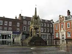 Market Cross |
| Moat Farmhouse (now Morteyne Manor) | Marston Moretaine | Farmhouse | Early 16th century | 22 October 1952 | SP9931041330 52°03′41″N 0°33′10″W |
1114050 | 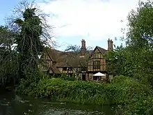 Moat Farmhouse (now Morteyne Manor) |
| Church of Saint Mary the Virgin | Maulden | Parish church | 14th century | 23 January 1961 | TL0584138054 52°01′51″N 0°27′31″W |
1321701 | 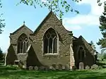 Church of Saint Mary the Virgin |
| Church of St Mary the Virgin | Meppershall | Parish church | 12th century | 31 October 1966 | TL1345935925 52°00′37″N 0°20′54″W |
1312589 | 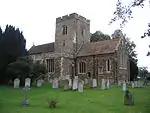 Church of St Mary the Virgin |
| St Thomas' Chapel approximately 20 metres south of Chapel Farmhouse | Meppershall | Chapel | c.1175 | 31 October 1966 | TL1471536215 52°00′45″N 0°19′48″W |
1113845 | |
| Church of St Michael | Millbrook | Parish church | 13th century | 23 January 1961 | TL0136238528 52°02′09″N 0°31′25″W |
1113934 | 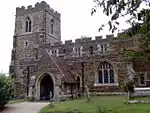 Church of St Michael |
| London Lodge, gateway and walls | Milton Bryan | Gate lodge | 1805–10 | 23 January 1961 | SP9633330890 51°58′05″N 0°35′57″W |
1311905 |  London Lodge, gateway and walls |
| Former principal stable block of Moggerhanger House | Mogerhanger | Stable | 1790–92 | 6 March 1985 | TL1351348640 52°07′28″N 0°20′36″W |
1113882 | 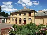 Former principal stable block of Moggerhanger House |
| Dovecote at Ickwell Bury | Ickwell, Northill | Dovecote | 1680s | 31 October 1966 | TL1458145657 52°05′51″N 0°19′43″W |
1321726 | |
| Barns at Warden Abbey Farm | Old Warden | Barn | Late 16th century | 16 March 1972 | TL1195843926 52°04′57″N 0°22′03″W |
1274805 | |
| Bridge between Upper and Middle Ponds | The Swiss Garden, Old Warden | Swiss garden | Late 19th century | 11 October 1973 | TL1498244757 52°05′21″N 0°19′23″W |
1222503 | 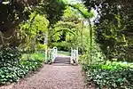 Bridge between Upper and Middle Ponds |
| The Grotto and Fernery | The Swiss Garden, Old Warden | Grotto | Early 1830s | 11 October 1973 | TL1492144703 52°05′20″N 0°19′27″W |
1222502 | |
| Moat bridge south of Middle Pond | The Swiss Garden, Old Warden | Swiss garden | Early 19th century | 11 October 1973 | TL1496044756 52°05′21″N 0°19′25″W |
1274616 | 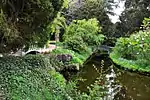 Moat bridge south of Middle Pond |
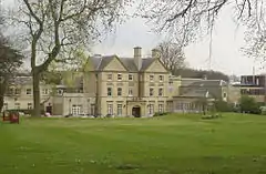
| Old Warden Park (Shuttleworth College) | Old Warden | House | Earlier | 6 March 1985 | TL1464444236 52°05′05″N 0°19′42″W |
1222169 | 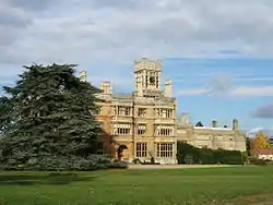 Old Warden Park (Shuttleworth College) |
| The Indian Kiosk | The Swiss Garden, Old Warden | Garden house | Early 19th century | 11 October 1973 | TL1493944790 52°05′22″N 0°19′26″W |
1237794 | 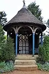 The Indian Kiosk |
| The North Bridge north of Middle Pond | The Swiss Garden, Old Warden | Swiss garden | Early 19th century | 11 October 1973 | TL1496244804 52°05′23″N 0°19′24″W |
1222504 | |
| The Swiss Cottage | The Swiss Garden, Old Warden | Garden house | 1820s | 11 October 1973 | TL1491344653 52°05′18″N 0°19′27″W |
1237818 |  The Swiss Cottage |
| Church of Saint Mary the Virgin | Potsgrove | Parish church | 14th century | 22 October 1952 | SP9515529851 51°57′32″N 0°37′00″W |
1321686 | |
| Church of St James | Pulloxhill | Church | 14th century | 23 January 1961 | TL0616233800 51°59′33″N 0°27′19″W |
1138002 | 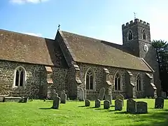 Church of St James |
| The Cross Keys Pulloxhill | Pulloxhill | Church | 17th century | 23 May 1985 | TL0633240800 51°59′42″N 0°27′11″W |
1138022 | 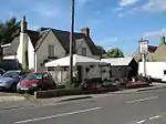 The Cross Keys Pulloxhill |
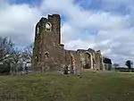
| Old Church of All Saints | Segenhoe, Ridgmont | Parish church | 12th century | 23 January 1961 | SP9811935789 52°00′43″N 0°34′18″W |
 Old Church of All Saints | |
| Parish Church of All Saints | Ridgmont | Parish church | 1854–55 | 23 January 1961 | SP9758736057 52°00′52″N 0°34′46″W |
1114055 |  Parish Church of All Saints |
| Segenhoe Manor | Segenhoe, Ridgmont | House | Early 18th century | 12 May 1993 | SP9825935995 52°00′49″N 0°34′11″W |
1158084 | |
| Church of St Swithun | Sandy | Church | Medieval | 21 December 1979 | TL1739349071 52°07′39″N 0°17′11″W |
1137790 | 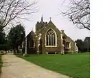 Church of St Swithun |
| Hazells Hall | Sandy | Country house | 1720s | 29 May 1979 | TL1892049999 52°08′08″N 0°15′50″W |
1137713 | |
| Catholic Church of St Francis of Assisi | Shefford | Roman Catholic church | 1884 | 10 January 1985 | TL1426039011 52°02′16″N 0°20′08″W |
1113767 | .jpg.webp) Catholic Church of St Francis of Assisi |
| Parish Church of Saint Margaret | Higham Gobion, Shillington | Parish church | 14th century | 23 January 1961 | TL1037832784 51°58′57″N 0°23′39″W |
1113758 | 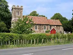 Parish Church of Saint Margaret |
| Bath house and cascade | Wrest Park, Silsoe | Bath house | c.1769–71 | 10 January 1985 | TL0888535350 52°00′21″N 0°24′54″W |
1113790 | 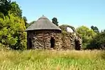 Bath house and cascade |
| Bowling Green House and two urns on pedestals 5m to the south-east and north-east | Wrest Park, Silsoe | Pavilion | c.1735 | 10 January 1985 | TL0896635110 49°46′01″N 7°33′26″W |
1158672 | 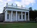 Bowling Green House and two urns on pedestals 5m to the south-east and north-east |
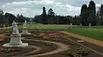
| Four statuary groups in the South Parterre (also known as the French Garden) south of Wrest House, depicting Aeneas and Anchises, the Abduction of Helen of Troy, Venus and Adonis and Meleager and Atalanta | Wrest Park, Silsoe | Statue | c.1730 | 10 January 1985 | TL0909535532 52°00′27″N 0°24′43″W |
1113789 | |
| Group of five altars approximately 50m south of Ladies Lake | Wrest Park, Silsoe | Altar | 1st–2nd century BCE | 10 January 1985 | TL0930635022 52°00′10″N 0°24′33″W |
1311237 | |
| Mithraic altar approximately 40m east of the Hutton Monument | Wrest Park, Silsoe | Garden ornament | 1748 | 10 January 1985 | TL0906734723 52°00′01″N 0°24′46″W |
1158808 | 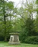 Mithraic altar approximately 40m east of the Hutton Monument |
| Orangery, steps and four cherub statues on pedestals | Wrest Park, Silsoe | Orangery | c.1835 | 10 January 1985 | TL0896935360 52°00′22″N 0°24′50″W |
1158549 | 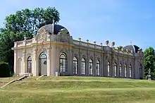 Orangery, steps and four cherub statues on pedestals |
| Statue of Lady Jemima, 27m South of the West Half House | Wrest Park, Silsoe | Statue | Erected c.1748 | 10 January 1985 | TL0903634879 52°00′06″N 0°24′47″W |
1113805 | 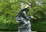 Statue of Lady Jemima, 27m South of the West Half House |
| Statue of William III 30m north of the Archer Pavilion | Wrest Park, Silsoe | Statue | 1730s | 10 January 1985 | TL0918034782 52°00′03″N 0°24′40″W |
1158878 | 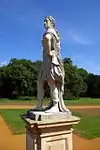 Statue of William III 30m north of the Archer Pavilion |
| Parish Church of All Saints | Southill | Church | 1814 | 31 October 1966 | TL1458742231 52°04′00″N 0°19′47″W |
1274447 | .jpg.webp) Parish Church of All Saints |
| The Temple | Southill Park, Southill | Garden building | c.1800 | 16 January 1952 | TL1449143179 52°04′31″N 0°19′51″W |
1237890 | |
| Church of St Mary the Virgin | Stotfold | Parish church | 12th century | 31 October 1966 | TL2202936680 52°00′54″N 0°13′24″W |
1113866 |  Church of St Mary the Virgin |
| Packhorse Bridge | Sutton | Bridge | 18th century | 31 October 1966 | TL2205847423 52°06′42″N 0°13′08″W |
1321630 |  Packhorse Bridge |
| Church of St Peter | Tempsford | Parish church | 14th century | 31 October 1966 | TL1619253032 52°09′48″N 0°18′10″W |
1114096 | 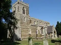 Church of St Peter |
| Gatehouse to Manor Farm | Tilsworth | Gatehouse | 15th century | 29 April 1952 | SP9761624201 51°54′28″N 0°34′57″W |
1114739 | 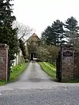 Gatehouse to Manor Farm |
| Church of Saint Mary Magdalen | Westoning | Parish church | 12th century | 23 January 1961 | TL0281232792 51°59′03″N 0°30′16″W |
1138118 | 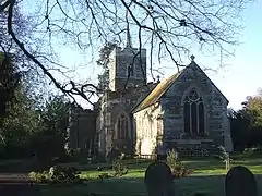 Church of Saint Mary Magdalen |
| Church of St Mary Magdalen | Whipsnade | Church | 15th century | 3 February 1967 | TL0117217959 51°51′04″N 0°31′57″W |
1159770 | 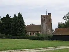 Church of St Mary Magdalen |
| Elephant House | Whipsnade Zoo, Whipsnade | Elephant house | 1935 | 1 September 1988 | TL0031617319 51°50′44″N 0°32′43″W |
1235411 | |
| Holly Frindle Bungalow | Whipsnade Zoo, Whipsnade | Bungalow | 1933–36 | 1 September 1988 | TL0002516903 51°50′30″N 0°32′58″W |
1321291 | |
| Atrium Antiques | Woburn | House | c.1725 | 22 October 1952 | SP9489233158 51°59′20″N 0°37′10″W |
1114002 | 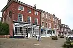 Atrium Antiques |
| Chinese Pavilion, at centre of maze | Woburn Park, Woburn | Garden building | c.1833 | 23 January 1961 | SP9671132292 51°58′50″N 0°35′36″W |
1158303 | 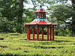 Chinese Pavilion, at centre of maze |
| Church of Saint Mary | Woburn | Parish church | 1865–68 | 1 March 1972 | SP9504033273 51°59′23″N 0°37′02″W |
1321663 | |
| North gatepier of pair adjacent to Lion Lodge | Woburn Park, Woburn | Gate pier | Mid-18th century | 23 January 1961 | SP9517833297 51°59′24″N 0°36′55″W |
1321664 | 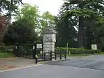 North gatepier of pair adjacent to Lion Lodge |
| Old Church of St Mary | Woburn | Parish church | 1865–68 | 23 January 1961 | SP9486633246 51°59′22″N 0°37′12″W |
1146524 | 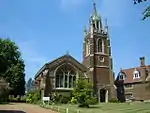 Old Church of St Mary |
| South Gatepier of Pair Adjacent to Lion Lodge | Woburn Park, Woburn | Gate pier | Mid-18th century | 23 January 1961 | SP9518233290 51°59′24″N 0°36′55″W |
1114005 | 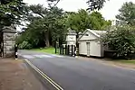 South Gatepier of Pair Adjacent to Lion Lodge |
| The Chestnuts | Woburn | House | Late 18th century | 22 October 1952 | SP9496433063 51°59′16″N 0°37′07″W |
1113991 | |
| The Gifford Gallery/Woburn Fine Arts | Woburn | House | Early 18th century | 22 October 1952 | SP9493433194 51°59′21″N 0°37′08″W |
1157988 | 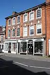 The Gifford Gallery/Woburn Fine Arts |
| The Grotto | Woburn Park, Woburn | Grotto | c.1839 | 23 January 1961 | SP9669032654 51°59′02″N 0°35′37″W |
1114010 | 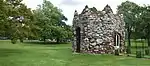 The Grotto |
| The Old Parsonage | Woburn | House | Mid-18th century | 22 October 1952 | SP9489633231 51°59′22″N 0°37′10″W |
1321695 | 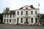 The Old Parsonage |
| The Thornery | Woburn Park, Woburn | Cottage ornee | 1808 | 4 August 1980 | SP9718334324 51°59′56″N 0°35′09″W |
1158441 | |
| 4–7 Market Place | Woburn | House | Late 18th century | 22 October 1952 | SP9493533173 51°59′20″N 0°37′08″W |
1157972 | 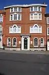 4–7 Market Place |
Luton
Luton has no Grade II* listed buildings.
Notes
| Wikimedia Commons has media related to Grade II* listed buildings in Bedfordshire. |
- The date given is the date used by Historic England as significant for the initial building or that of an important part in the structure's description.
- Sometimes known as OSGB36, the grid reference is based on the British national grid reference system used by the Ordnance Survey.
- The "List Entry Number" is a unique number assigned to each listed building and scheduled monument by Historic England.
This article is issued from Wikipedia. The text is licensed under Creative Commons - Attribution - Sharealike. Additional terms may apply for the media files.