Grade II* listed buildings in the City of Carlisle
There are over 20,000 Grade II* listed buildings in England. This page is a list of these buildings in the City of Carlisle in Cumbria.
List of buildings
| Name | Location | Type | Completed [note 1] | Date designated | Grid ref.[note 2] Geo-coordinates |
Entry number [note 3] | Image |
|---|---|---|---|---|---|---|---|
| Brackenhill Tower | Arthuret | House | 1586 | 1 April 1957 | NY4458169480 55°01′00″N 2°52′06″W |
1087521 |  |
| Church of St Michael | Arthuret | Church | 1609 | 1 April 1957 | NY3793967666 54°59′59″N 2°58′18″W |
1087523 | 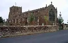 Church of St Michael |
| Churchyard cross west of Church of St Michael | Arthuret | Cross | 12th or 13th century | 15 June 1984 | NY3788967655 54°59′58″N 2°58′21″W |
1087524 | |
| Coop House, north-west of Netherby Hall | Netherby, Arthuret | Estate cottage | Mid-18th century | 15 June 1984 | NY3866971474 55°02′02″N 2°57′40″W |
1204976 | 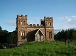 Coop House, north-west of Netherby Hall |
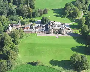
| Netherby Hall | Netherby, Arthuret | House | 15th century and later | 1 April 1957 | NY3966371613 55°02′07″N 2°56′44″W |
1204948 | |
| Church of St Mary | Beaumont | Church | Late 12th century | 1 May 1957 | NY3481159298 54°55′27″N 3°01′07″W |
1335624 | 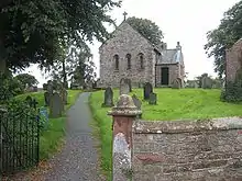 Church of St Mary |
| Church of St Cuthbert | Bewcastle | Church | 13th century | 1 April 1957 | NY5654274561 55°03′49″N 2°40′55″W |
1087539 | 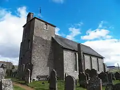 Church of St Cuthbert |
| Church of St Martin (Brampton Old Church) | Brampton | Church | 12th century | 1 April 1951 | NY5101461557 54°56′47″N 2°45′59″W |
1087645 |  Church of St Martin (Brampton Old Church) |
| Four Gables | Brampton | House | 1879 | 13 February 1963 | NY5434661632 54°56′50″N 2°42′51″W |
1087651 | |
| Moot Hall | Brampton, Brampton | Moot hall | 1817 | 1 April 1957 | NY5307461088 54°56′32″N 2°44′03″W |
1137330 |  Moot Hall |
| Old Church Farmhouse | Brampton | Farmhouse | Early 14th century | 16 January 1984 | NY5102861598 54°56′48″N 2°45′58″W |
1087646 | |
| Barn adjoining to north of Moorhouse Farmhouse | Moorhouse, Burgh By Sands | Barn | Late 17th century | 22 November 1973 | NY3298856826 54°54′06″N 3°02′48″W |
1335655 | |
| King Edward I Monument | Sandsfield, Burgh By Sands | Commemorative monument | 1685 | 1 April 1957 | NY3257460920 54°56′18″N 3°03′14″W |
1087463 | 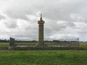 King Edward I Monument |
| Lamonby Farmhouse and adjoining barn | Burgh By Sands | Farmhouse | Mid-17th century | 19 September 1984 | NY3270859170 54°55′22″N 3°03′05″W |
1039874 |  Lamonby Farmhouse and adjoining barn |
| Church of St Michael and All Angels | Dalston | Church | 12th century | 19 September 1984 | NY3694450162 54°50′32″N 2°59′00″W |
1374153 | 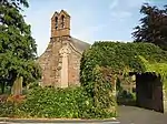 Church of St Michael and All Angels |
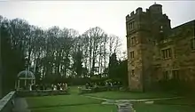
| Dalston Hall | Dalston | Fortified house | 1433–99 | 19 September 1984 | NY3765851566 54°51′18″N 2°58′21″W |
1087441 | |
| Dovecote to north-east of Rose Castle | Dalston | Dovecote | 1700 | 19 September 1984 | NY3712546348 54°48′29″N 2°58′47″W |
1087474 | |
| Hawkesdale Hall | Hawkesdale, Dalston | House | Late 17th century | 19 September 1984 | NY3746447710 54°49′13″N 2°58′29″W |
1335649 | |
| Church of St Mary Magdalen | Hayton | Church | 1780 | 1 April 1957 | NY5078657692 54°54′41″N 2°46′09″W |
1335622 | 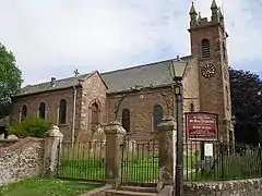 Church of St Mary Magdalen |
| Gelt Bridge | Hayton | Railway bridge | 1832–35 | 1 April 1957 | NY5324757324 54°54′30″N 2°43′51″W |
1335587 |  Gelt Bridge |
| Church of St Kentigern | Irthington | Church | 12th century | 1 April 1957 | NY4987661634 54°56′49″N 2°47′03″W |
1335584 | 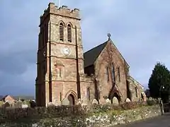 Church of St Kentigern |
| Church of St Andrew | Kirkandrews on Esk | Church | 1776 | 1 April 1957 | NY3911071982 55°02′19″N 2°57′16″W |
1087506 | 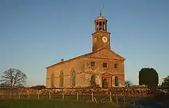 Church of St Andrew |
| Kirkandrews Tower | Kirkandrews on Esk | House | 18th century | 1 April 1957 | NY3891471928 55°02′17″N 2°57′27″W |
1205396 |  Kirkandrews Tower |
| Riddings Junction Viaduct | Kirkandrews on Esk | Railway viaduct | 1864 | 31 October 1996 | NY4107275585 55°04′16″N 2°55′28″W |
1268307 | 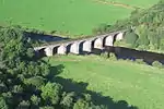 Riddings Junction Viaduct |
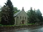
| Church of St Cuthbert | Kirklinton | Church | 1845 | 16 January 1984 | NY4326667038 54°59′41″N 2°53′18″W |
1335549 |  Church of St Cuthbert |
| Tarn House | Midgeholme | Farmhouse | Late 15th century | 1 April 1957 | NY6061358486 54°55′10″N 2°36′58″W |
1051067 |  Tarn House |
| Stonegarthside Hall | Nicholforest | House | 1682 | 15 June 1984 | NY4803981860 55°07′42″N 2°48′59″W |
1335605 | 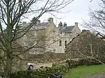 Stonegarthside Hall |
| Church of St Giles | Great Orton, Orton | Church | 12th century | 19 September 1984 | NY3289454287 54°52′44″N 3°02′51″W |
1087417 | 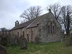 Church of St Giles |
| Castletown | Rockcliffe | House | 1811 | 1 April 1957 | NY3480662098 54°56′57″N 3°01′10″W |
1087596 | |
| Church of St Mary | Rockcliffe | Church | 1848 | 1 April 1957 | NY3588061643 54°56′43″N 3°00′09″W |
1087594 | 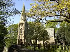 Church of St Mary |
| Church of St Mary | Wreay, St. Cuthbert Without | Church | 1840–42 | 1 April 1957 | NY4352548921 54°49′55″N 2°52′51″W |
1087758 | |
| Newbiggin Hall | St. Cuthbert Without | House | Early 19th century | 14 September 1954 | NY4330350858 54°50′57″N 2°53′04″W |
1087720 | 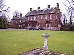 Newbiggin Hall |
| Brunstock House | Brunstock, Stanwix Rural | House | 1827–33 | 22 September 1983 | NY4188159419 54°55′34″N 2°54′30″W |
1087726 | |
| Drawdykes Castle | Drawdykes, Stanwix Rural | Farmhouse | c.1764 | 1 April 1957 | NY4190758549 54°55′06″N 2°54′28″W |
1087728 | |
| Linstock Castle | Linstock, Stanwix Rural | Farmhouse, former tower house | 12th or early 13th century | 1 April 1957 | NY4289758484 54°55′04″N 2°53′33″W |
1119608 | |
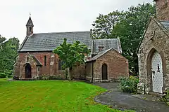
| Temon and adjoining outbuilding | Upper Denton | Farmhouse | Late 17th century | 1 April 1957 | NY6169963825 54°58′03″N 2°35′59″W |
1087520 |  Temon and adjoining outbuilding |
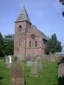
| Upper Denton Church | Upper Denton | Church | Early 12th century | 1 April 1957 | NY6156065514 54°58′58″N 2°36′08″W |
1087564 | _-_geograph.org.uk_-_1564435.jpg.webp) Upper Denton Church |
| Church of St Mary | Walton | Church | 1869–70 | 16 January 1984 | NY5221664490 54°58′22″N 2°44′53″W |
1157868 | |
| Church of St Leonard | Warwick, Wetheral | Church | 12th century | 1 April 1957 | NY4660056800 54°54′11″N 2°50′03″W |
1121876 | 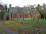 Church of St Leonard |
| Church of St Mary and St Wilfred | Warwick Bridge, Wetheral | Roman Catholic church | 1841 | 1 April 1957 | NY4752156817 54°54′12″N 2°49′12″W |
1111897 | |
| Church of the Holy Trinity and St Constantine | Wetheral | Church | 13th century | 1 April 1957 | NY4681754401 54°52′53″N 2°49′50″W |
1087692 | 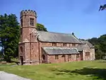 Church of the Holy Trinity and St Constantine |
| Holme Eden Abbey | Warwick Bridge, Wetheral | Abbey | 1833–37 | 3 September 1973 | NY4717957001 54°54′18″N 2°49′31″W |
1087685 | |
| Statue of Polyphemus, Corby Castle | Great Corby, Wetheral | Statue | Early 18th century | 22 September 1983 | NY4706654039 54°52′42″N 2°49′35″W |
1087675 | |
| The Corn Mill | Warwick Bridge, Wetheral | Watermill | 1839 | 22 September 1983 | NY4741656908 54°54′15″N 2°49′18″W |
1087686 | 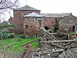 The Corn Mill |
| Bishop's Registry | The Abbey | Library | 1699 | 1 June 1949 | NY3981255942 54°53′40″N 2°56′24″W |
1197012 | 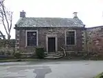 Bishop's Registry |
| Church of St Cuthbert with St Mary | Carlisle | Church | 1778 | 1 June 1949 | NY3996455843 54°53′37″N 2°56′15″W |
1218565 | 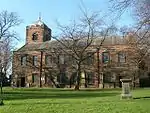 Church of St Cuthbert with St Mary |
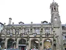
| Citadel Station | Carlisle | Railway station | 1847–48 | 13 November 1972 | NY4023655540 54°53′28″N 2°56′00″W |
1196969 | |
| Coledale Hall | Carlisle | House | 1810 | 1 June 1949 | NY3836755999 54°53′42″N 2°57′45″W |
1196932 |  Coledale Hall |
| Congregational Church | Carlisle | Church | 1842–43 | 22 March 1974 | NY4026755752 54°53′35″N 2°55′58″W |
1196929 |  Congregational Church |
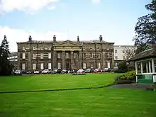
| Cumberland Infirmary | Carlisle | Hospital | 1830–32 | 13 November 1972 | NY3883156084 54°53′45″N 2°57′19″W |
1218237 | |
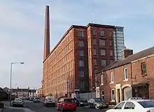
| Dixons Chimney at Shaddon Mill | Carlisle | Cotton mill | 1836 | 13 November 1972 | NY3946255644 54°53′31″N 2°56′43″W |
1196919 | |
| Monument to Peter Nicholson, north-west of cemetery chapel | Carlisle | Commemorative monument | 1855–56 | 11 April 1994 | NY3911354377 54°52′50″N 2°57′02″W |
1218406 | |
| Mulcaster House | Carlisle | House | Late 18th century | 1 June 1949 | NY4022057035 54°54′16″N 2°56′02″W |
1196986 | |
| No 32 Abbey Street and railings to front | Carlisle | House | c.1817 | 1 June 1949 | NY3974255984 54°53′42″N 2°56′28″W |
1293020 |  No 32 Abbey Street and railings to front |
| Nos 26, 28 and 30 Castle Street and railings to front | Carlisle | Apartment | 1823 | 1 June 1949 | NY3981956047 54°53′44″N 2°56′24″W |
1355058 |  Nos 26, 28 and 30 Castle Street and railings to front |
| Petteril Bank [now Cumbria Archives] | Carlisle | House | 1829 | 11 April 1994 | NY4160153628 54°52′26″N 2°54′42″W)] |
1297373 |  Petteril Bank [now Cumbria Archives] |
| Shaddon Mill | Carlisle | Cotton mill | 1835–36 | 1 June 1949 | NY3951455628 54°53′30″N 2°56′40″W |
1297383 | |
| Trustee Savings (now Lloyds) Bank and attached railings | Carlisle | Bank | 1874 | 1 June 1949 | NY4026355779 54°53′35″N 2°55′58″W |
1196930 |  Trustee Savings (now Lloyds) Bank and attached railings |
| 18 Fisher Street | Carlisle | House | Late 18th century | 1 June 1949 | 49°46′01″N 7°33′26″W | 1196951 | |
| 26 Abbey Street | Carlisle | House | Late 18th century | 1 June 1949 | NY3972255993 54°53′42″N 2°56′29″W |
1196981 | 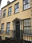 26 Abbey Street |
| 2 The Abbey | Carlisle | Clergy house | Late 17th century | 1 June 1949 | NY3982955956 54°53′41″N 2°56′23″W |
1197013 | 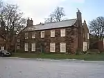 2 The Abbey |
| 21 Castle Street | Carlisle | House | Late 18th century | 1 June 1949 | NY3988356044 54°53′44″N 2°56′20″W |
1297358 |  21 Castle Street |
| 24 Abbey Street | Carlisle | House | Early 19th century | 1 June 1949 | NY3971656002 54°53′42″N 2°56′29″W |
1297355 |  24 Abbey Street |
| 19, 21 and 23 Victoria Place | Carlisle | House | Early 1870s | 13 November 1972 | NY4035356001 54°53′43″N 2°55′54″W |
1197137 | |
| 2 Albert Street | Carlisle | Terrace | 1852–54 | 1 June 1949 | NY4031856035 54°53′44″N 2°55′56″W |
1297274 | |
| 3 and 6 The Abbey | Carlisle | Clergy house | Late 17th century | 1 June 1949 | NY3994355915 54°53′40″N 2°56′16″W |
1293105 |  3 and 6 The Abbey |
| 3–17 Victoria Place | Carlisle | Terrace | Late 1840s | 1 June 1949 | NY4028255981 54°53′42″N 2°55′57″W |
1197136 | |
| 2 Victoria Place | Carlisle | House | 1830s | 13 November 1972 | NY4025256022 54°53′43″N 2°55′59″W |
1218796 | |
| 1 Victoria Place | Carlisle | House | 1830s | 13 November 1972 | NY4026855981 54°53′42″N 2°55′58″W |
1196918 | |
| Cumberland and Westmorland Joint Counties’ War Memorial | Rickerby Park, Carlisle | War memorial | 1922 | 11 April 1994 | NY4090956844 54°54′10″N 2°55′23″W |
1291971 |  Cumberland and Westmorland Joint Counties’ War Memorial |


See also
Notes
- The date given is the date used by Historic England as significant for the initial building or that of an important part in the structure's description.
- Sometimes known as OSGB36, the grid reference is based on the British national grid reference system used by the Ordnance Survey.
- The "List Entry Number" is a unique number assigned to each listed building and scheduled monument by Historic England.
External links
This article is issued from Wikipedia. The text is licensed under Creative Commons - Attribution - Sharealike. Additional terms may apply for the media files.