Grade II* listed buildings in Exeter
There are over 20,000 Grade II* listed buildings in England. This page is a list of these buildings in the district of Exeter in Devon.
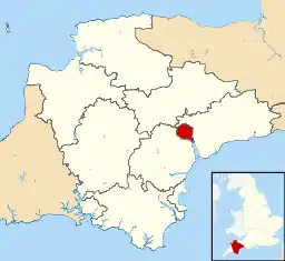
Exeter shown in Devon
Buildings
| Name | Location | Type | Completed [note 1] | Date designated | Grid ref.[note 2] Geo-coordinates |
Entry number [note 3] | Image |
|---|---|---|---|---|---|---|---|
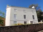
| Bellair | Exeter | House | c. 1700 | 29 January 1953 | SX9295691709 50°42′54″N 3°31′03″W |
1224137 | 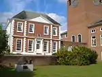 Bellair |
| Boundary Wall, Piers and Gates of Broadway House | Topsham, Exeter | Gate | 1776 | 11 November 1952 | SX9648188309 50°41′07″N 3°28′00″W |
1333434 |  |
| Broadway House | Topsham, Exeter | House | 1776 | 11 November 1952 | SX9649088316 50°41′07″N 3°28′00″W |
1103877 |  Broadway House |
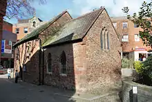
| Chapel at St Anne's Almshouses | Exeter | Chapel | 15th century | 29 January 1953 | SX9280393293 50°43′46″N 3°31′13″W |
1380202 | |
| Chichester Place | Exeter | Terrace | 1824–25 | 29 January 1953 | SX9238792676 50°43′25″N 3°31′33″W |
1223851 |  Chichester Place |
| Church House | Exeter | House | 17th century | 29 January 1953 | SX9206892501 50°43′19″N 3°31′49″W |
1225195 | |
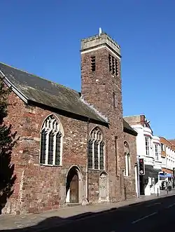
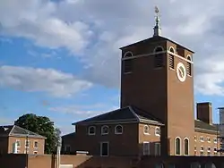
| Church of Saint Michael and All Angels | Heavitree, Exeter | Church | Medieval origins, rebuilt 1844–46 | 29 January 1953 | SX9375792266 50°43′13″N 3°30′23″W |
1333344 | _-_geograph.org.uk_-_1065240.jpg.webp) Church of Saint Michael and All Angels |
| Church of St Andrew | Exwick, Exeter | Chapel of ease | 1841–42 | 18 June 1974 | SX9085093620 50°43′55″N 3°32′53″W |
1223954 |  Church of St Andrew |
| Church of St Michael | Alphington, Exeter | Church | Late 15th century | 30 June 1961 | SX9183689982 50°41′58″N 3°31′59″W |
1103980 |  Church of St Michael |
| Church of St Michael and All Angels | Pinhoe, Exeter | Church | Late 14th to early 15th century | 30 June 1961 | SX9552094973 50°44′42″N 3°28′56″W |
1104037 | 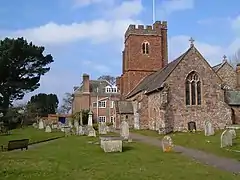 Church of St Michael and All Angels |
| Church of St Olave | Exeter | Church | 14th century | 29 January 1953 | SX9181892466 50°43′18″N 3°32′02″W |
1103969 | |
| Church of St Pancras | Exeter | Church | 13th century | 29 January 1953 | SX9192292693 50°43′26″N 3°31′57″W |
1222964 | |
| Church of St Petrock | Exeter | Church | Early 15th century | 29 January 1953 | SX9194692576 50°43′22″N 3°31′56″W |
1333409 | |
| Church of St Stephen | Exeter | Church | 1664 | 29 January 1953 | SX9211392722 50°43′27″N 3°31′47″W |
1170488 | |
| Civic Hall and Higher Market | Exeter | Hall | 1838 | 18 June 1974 | SX9193992750 50°43′27″N 3°31′56″W |
1223245 |  Civic Hall and Higher Market |
| Clara Place | Topsham, Exeter | House | 1841 | 11 November 1952 | SX9641888280 50°41′06″N 3°28′03″W |
1103963 |  Clara Place |
| Railings, Steps and Cast Iron Piers at Clara Place | Topsham, Exeter | Railings | 1841 | 11 November 1952 | SX9643288266 50°41′05″N 3°28′03″W |
1170221 | |
| Cleve House | Exeter | House | Late 17th century | 29 January 1953 | SX9017393217 50°43′41″N 3°33′27″W |
1306243 | |
| Colleton Villa | Exeter | Villa | c. 1830 | 18 June 1974 | SX9208592130 50°43′07″N 3°31′48″W |
1333380 |  Colleton Villa |
| Cowick Barton | Exeter | House | 1540 | 29 January 1953 | SX9089691112 50°42′34″N 3°32′48″W |
1104011 |  Cowick Barton |
| Cromer House | Topsham, Exeter | House | 1720 | 11 November 1952 | SX9657487965 50°40′56″N 3°27′55″W |
1306102 |  Cromer House |
| Devon and Exeter Institution | Exeter | Town house | 16th century or earlier | 29 January 1953 | SX9215592614 50°43′23″N 3°31′45″W |
1104062 | |
| Devon County Hall | St Leonards, Exeter | County hall | 1964 | 24 April 1998 | SX9295891644 50°42′52″N 3°31′03″W |
1323701 | |
| Devon County War Memorial and Processional Way | Exeter | War memorial | 1921 (Memorial), 1974 (Way) | 16 April 2009 | SX9199192567 50°43′22″N 3°31′53″W |
1393228 | 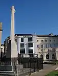 Devon County War Memorial and Processional Way |
| Exeter City War Memorial | Exeter | War memorial | 1923 | 8 September 2014 | SZ0843191322 50°43′35″N 3°31′54″W |
1420669 | |
| Exeter Country Club (Weare House) | Exeter | Country house | Probably c. 1804 | 29 January 1953 | SX9502689910 50°41′58″N 3°29′16″W |
1224192 | |
| Fish Market | Kings Beam, Exeter | Fish market | c. 1838 | 18 June 1974 | SX9201792095 50°43′06″N 3°31′52″W |
1223047 |  Fish Market |
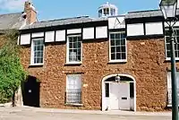
| Harbourmaster's Office | Exeter | Harbour Master's office | 18th century | 29 January 1953 | SX9200692144 50°43′08″N 3°31′52″W |
1223041 |  Harbourmaster's Office |
| Imperial Hotel | Exeter | House | c. 1810 | 29 January 1953 | SX9142693429 50°43′49″N 3°32′23″W |
1222697 | .jpg.webp) Imperial Hotel |
| Iron Footbridge | Exeter | Footbridge | 1814 | 29 January 1953 | SX9226092534 50°43′21″N 3°31′40″W |
1333351 |  Iron Footbridge |
| Notaries' House | Exeter | House | Early 18th century | 29 January 1953 | SX9217292599 50°43′23″N 3°31′44″W |
1306408 |  Notaries' House |
| Old Matford | Wonford Rd, Exeter | House | c. 1600 | 29 January 1953 | SX9329291836 50°42′59″N 3°30′46″W |
1224370 |  Old Matford |
| Old Tudor House (Tiddy House) | Exeter | House | Late 16th century | 29 January 1953 | SX9159292287 50°43′12″N 3°32′13″W |
1266938 |  Old Tudor House (Tiddy House) |
| Pinbrook House | Exeter | Manor house | 1679 | 11 November 1952 | SX9523794560 50°44′28″N 3°29′10″W |
1104086 |  Pinbrook House |
| Polsloe Priory | Exeter | Priory | 13th century | 29 January 1953 | SX9411493814 50°44′03″N 3°30′06″W |
1169490 | |
| Rougemont House | Exeter | House | Early 19th century | 29 January 1953 | SX9212192895 50°43′32″N 3°31′47″W |
1169610 | |
| Royal Devon and Exeter Hospital | Exeter | Hospital | By 1758 | 18 June 1974 | SX9227092376 50°43′16″N 3°31′39″W |
1267091 | |
| Salutation Hotel | Topsham, Exeter | Hotel | Probably c. 1720 | 11 November 1952 | SX9655088114 50°41′00″N 3°27′57″W |
1103914 |  Salutation Hotel |
| Shell House | Topsham, Exeter | House | Late 17th century | 11 November 1952 | SX9670387724 50°40′48″N 3°27′48″W |
1267061 |  Shell House |
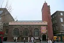
| Sidwell Street Methodist Church | Exeter | Methodist chapel | 31 October 1983 | SX9260593155 50°43′41″N 3°31′23″W |
1224385 | 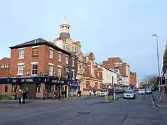 Sidwell Street Methodist Church | |
| Southernhay House | Exeter | House | Early 19th century | 29 January 1953 | SX9234392490 50°43′19″N 3°31′35″W |
1223853 |  Southernhay House |
| St Margaret's Church | Topsham, Exeter | Church | 15th century tower | 30 June 1961 | SX9653788029 50°40′58″N 3°27′57″W |
1170373 |  St Margaret's Church |
| St Olave's Home | Exeter | House | Probably 18th century | 29 January 1953 | SX9168492538 50°43′20″N 3°32′09″W |
1104074 | |
| Synagogue | Synagogue Place, Exeter | Synagogue | 1764 | 29 January 1953 | SX9181692558 50°43′21″N 3°32′02″W |
1273591 | |
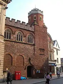
| The Castle (Crown Court) | Exeter | Court | 1774 | 29 January 1953 | SX9208393002 50°43′36″N 3°31′49″W |
1169617 | |
| 1, The Cloisters | Exeter | House | 1762 | 29 January 1953 | SX9205892518 50°43′20″N 3°31′50″W |
1104025 |  1, The Cloisters |
| 2, The Cloisters | Exeter | House | 1762 | 29 January 1953 | SX9205692509 50°43′20″N 3°31′50″W |
1333353 | 2, The Cloisters |
| The Deanery | Exeter | Deanery | Probably 15th century | 29 January 1953 | SX9201592511 50°43′20″N 3°31′52″W |
1104026 | |
| Tuckers Hall | Exeter | Hall | 15th century | 29 January 1953 | SX9172592357 50°43′15″N 3°32′07″W |
1103965 |  Tuckers Hall |
| Warehouse Vaults (1–4, The Quay) | Exeter | Warehouse | 1825 | 29 January 1953 | SX9217491981 50°43′03″N 3°31′43″W |
1223045 |  Warehouse Vaults (1–4, The Quay) |
| Warehouse Vaults (6–11, The Quay) | Exeter | Warehouse | 29 January 1953 | SX9207092094 50°43′06″N 3°31′49″W |
1223046 |  Warehouse Vaults (6–11, The Quay) | |
| Wynard's Hospital | Exeter | Almshouse | 17th century | 29 January 1953 | SX9234892327 50°43′14″N 3°31′35″W |
1239565 |  Wynard's Hospital |
| 2, Cathedral Close | Exeter | Timber-framed house | 17th century or earlier | 29 January 1953 | SX9210892645 50°43′24″N 3°31′48″W |
1333329 | |
| 3, Cathedral Close | Exeter | Timber-framed house | 17th century or earlier | 29 January 1953 | SX9211292642 50°43′24″N 3°31′47″W |
1169629 | |
| 4, Cathedral Close | Exeter | Timber-framed house | 17th century or earlier | 29 January 1953 | SX9211692639 50°43′24″N 3°31′47″W |
1104061 | |
| 6, Cathedral Close | Exeter | House | 18th century or earlier | 29 January 1953 | SX9213792625 50°43′24″N 3°31′46″W |
1333330 | |
| 15 and 15a, Cathedral Close | Exeter | House | c. 1740 | 29 January 1953 | SX9219192555 50°43′21″N 3°31′43″W |
1104021 | |
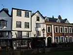
| 40, High Street | Exeter | House | Late 17th century | 29 January 1953 | SX9205292673 50°43′25″N 3°31′50″W |
1103897 | |
| 41 and 42 High Street | Exeter | Timber-framed house | 1564 | 29 January 1953 | SX9204792667 50°43′25″N 3°31′51″W |
1170491 | 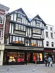 41 and 42 High Street |
| 46, High Street | Exeter | Timber-framed house | 16th century or earlier | 29 January 1953 | SX9203392655 50°43′24″N 3°31′51″W |
1103899 | |
| 225 and 226, High Street | Exeter | House | Reputedly built 1567 | 29 January 1953 | SX9203992722 50°43′27″N 3°31′51″W |
1170556 |  225 and 226, High Street |
| 227, High Street | Exeter | House | Mid 17th century | 29 January 1953 | SX9205092729 50°43′27″N 3°31′51″W |
1103907 | 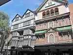 227, High Street |
| 26, The Strand | Topsham, Exeter | Merchant's house | Late 17th century | 11 November 1952 | SX9675587641 50°40′45″N 3°27′46″W |
1224027 |  26, The Strand |
| Wall and Gates of No 26, The Strand | Topsham, Exeter | Gate | 18th century | 11 November 1952 | SX9674387632 50°40′45″N 3°27′46″W |
1267065 | Wall and Gates of No 26, The Strand |
| 27, The Strand | Topsham, Exeter | Merchant's house | Late 17th century | 11 November 1952 | SX9675487627 50°40′45″N 3°27′46″W |
1224066 |  27, The Strand |
| Wall and Gates of No 27, The Strand | Topsham, Exeter | Gate | 18 June 1974 | SX9674987619 50°40′45″N 3°27′46″W |
1266994 | | |
| 28, The Strand | Topsham, Exeter | Counting house | Late 17th century | 11 November 1952 | SX9675787617 50°40′44″N 3°27′45″W |
1224068 | 28, The Strand |
| 34, The Strand | Topsham, Exeter | Merchant's house | Late 17th century | 11 November 1952 | SX9677487581 50°40′43″N 3°27′45″W |
1224070 | |
| No 40, The Strand (the Dutch House) including the Garage and the Dutch House | Topsham, Exeter | Merchant's house | Late 17th century | 11 November 1952 | SX9680087505 50°40′41″N 3°27′43″W |
1224078 | |
| Wall and Piers of No 40, The Strand | Topsham, Exeter | Wall | 18th century | 18 June 1974 | SX9679287498 50°40′41″N 3°27′44″W |
1224110 | |
| 1, Upper Paul Street | Exeter | House | Early 18th century | 29 January 1953 | SX9197792826 50°43′30″N 3°31′54″W |
1224196 | |
| 1–5, Pennsylvania Crescent | Exeter | Villa | c. 1820 | 29 January 1953 | SX9241793670 50°43′58″N 3°31′33″W |
1222965 | 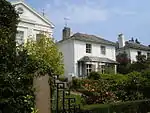 1–5, Pennsylvania Crescent |
| 1–10, Southernhay West | Exeter | Terrace | Early 19th century | 29 January 1953 | SX9226892484 50°43′19″N 3°31′39″W |
1223945 |  1–10, Southernhay West |
| 13–24, Southernhay West | Exeter | House | 29 January 1953 | SX9229792574 50°43′22″N 3°31′38″W |
1267058 |  13–24, Southernhay West | |
| 1–6, Pennsylvania Park | Exeter | Terrace | 1823 | 29 January 1953 | SX9275394316 50°44′19″N 3°31′16″W |
1222966 | 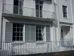 1–6, Pennsylvania Park |
| 12 and 14, Magdalen Road | Exeter | House | 1830–40 | 29 January 1953 | SX9268092344 50°43′15″N 3°31′18″W |
1239511 | |
| 21, The Mint | Exeter | Priory building | 15th century | 29 January 1953 | SX9174792501 50°43′19″N 3°32′06″W |
1239753 | |
| 67, South Street | Exeter | Timber-framed house | Probably early 17th century | 29 January 1953 | SX9205192346 50°43′14″N 3°31′50″W |
1267088 |  67, South Street |
| 2–6, Barnfield Crescent | Exeter | Terrace | 1805 | 29 January 1953 | SX9244592644 50°43′24″N 3°31′30″W |
1306533 |  2–6, Barnfield Crescent |
| 13–15, Dix's Field | Exeter | House | c. 1810 | 29 January 1953 | SX9251492703 50°43′26″N 3°31′27″W |
1333372 |  13–15, Dix's Field |
| 151–155, Magdalen Road | Exeter | House | c. 1810 | 29 January 1953 | SX9336992457 50°43′19″N 3°30′43″W |
1239559 | 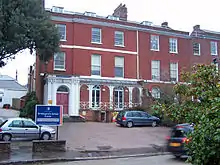 151–155, Magdalen Road |
| 1–9, Colleton Crescent | Exeter | Terrace | c. 1805 | 29 January 1953 | SX9217392061 50°43′05″N 3°31′44″W |
1104007 |  1–9, Colleton Crescent |
| 1 and 2, Catherine Street | Exeter | House | Probably 15th century | 29 January 1953 | SX9208992661 50°43′25″N 3°31′49″W |
1104031 |  1 and 2, Catherine Street |
| 5 and 7, West Street | Exeter | Timber-framed house | Probably 15th century | 29 January 1953 | SX9177492259 50°43′11″N 3°32′04″W |
1266893 |  5 and 7, West Street |
| 34–40, Wonford Road | Exeter | House | c. 1840 | 29 January 1953 | SX9270292220 50°43′11″N 3°31′17″W |
1266873 | 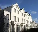 34–40, Wonford Road |
.jpg.webp)

.jpg.webp)


See also
Notes
- The date given is the date used by Historic England as significant for the initial building or that of an important part in the structure's description.
- Sometimes known as OSGB36, the grid reference is based on the British national grid reference system used by the Ordnance Survey.
- The "List Entry Number" is a unique number assigned to each listed building and scheduled monument by Historic England.
External links
![]() Media related to Grade II* listed buildings in Devon at Wikimedia Commons
Media related to Grade II* listed buildings in Devon at Wikimedia Commons
This article is issued from Wikipedia. The text is licensed under Creative Commons - Attribution - Sharealike. Additional terms may apply for the media files.