Grade II* listed buildings in Epping Forest (district)
There are over 20,000 Grade II* listed buildings in England. This page is a list of these buildings in the district of Epping Forest in Essex.
Epping Forest
| Name | Location | Type | Completed [note 1] | Date designated | Grid ref.[note 2] Geo-coordinates |
Entry number [note 3] | Image |
|---|---|---|---|---|---|---|---|
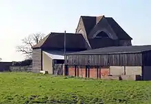
| Barn North East of Rookwood Hall | Abbess Beauchamp and Berners Roding, Epping Forest | Moat | 15th century | 20 February 1967 | TL5608411006 51°46′33″N 0°15′40″E |
1111340 |  |
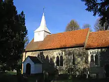
| Church of St Botolph | Beauchamp Roding, Epping Forest | Parish Church | Earlier origins | 20 February 1967 | TL5779309718 51°45′50″N 0°17′07″E |
1165815 | 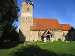 Church of St Botolph |
| Fairlands including attached Garden Wall and Pump | Abbess Beauchamp and Berners Roding, Epping Forest | House | 15th century | 29 June 1984 | TL5579411455 51°46′48″N 0°15′25″E |
1165784 | |
| Blake Hall | Bobbingworth, Epping Forest | House | 18th century | 20 February 1967 | TL5387905116 51°43′25″N 0°13′35″E |
1147912 | |
| Church of St Germain | Bobbingworth, Epping Forest | Church | 13th century | 20 February 1967 | TL5340805581 51°43′41″N 0°13′11″E |
1124089 |  Church of St Germain |
| Chigwell School | Chigwell, Epping Forest | Teacher's House | c. 1620 | 28 June 1954 | TQ4415093863 51°37′30″N 0°04′52″E |
1111240 | |
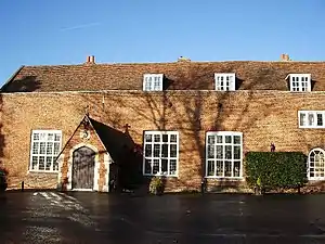
| Grange Court | Chigwell, Epping Forest | House | Late 18th century | 28 June 1954 | TQ4411193673 51°37′24″N 0°04′50″E |
1337265 | 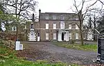 Grange Court |
| Parish Church of St Mary the Virgin | Chigwell, Epping Forest | Parish Church | 12th century | 28 June 1954 | TQ4410493790 51°37′28″N 0°04′49″E |
1165405 | 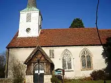 Parish Church of St Mary the Virgin |
| Tailours | Chigwell, Epping Forest | House | Early 18th century | 28 June 1954 | TQ4434894482 51°37′50″N 0°05′03″E |
1111235 | |
| The Kings Head Hotel | Chigwell, Epping Forest | Jettied House | 17th century | 28 June 1954 | TQ4414293784 51°37′28″N 0°04′51″E |
1111231 | 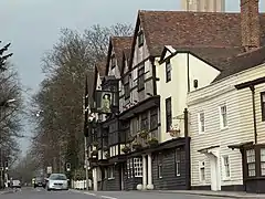 The Kings Head Hotel |
| Church of St John the Baptist | Epping, Epping Forest | Parish Church | 1889-1891 | 14 January 1972 | TL4595302103 51°41′55″N 0°06′38″E |
1337450 | 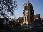 Church of St John the Baptist |
| Epping Place | Epping, Epping Forest | House | Before 1706 | 7 November 1949 | TL4537801621 51°41′40″N 0°06′07″E |
1337460 | |
| Church of All Saints | Epping Upland, Epping Forest | Parish Church | 13th century | 20 February 1967 | TL4439104510 51°43′15″N 0°05′20″E |
1111168 | 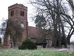 Church of All Saints |
| Parvills | Epping Upland, Epping Forest | House | 17th century | 22 February 1952 | TL4243103917 51°42′57″N 0°03′37″E |
1111164 | .jpg.webp) Parvills |
| Bridge House | Dunmow Rd, Fyfield, Epping Forest | House | Late 16th century | 7 April 1983 | TL5714007112 51°44′26″N 0°16′28″E |
1337246 | |
| Church of St Nicholas | Fyfield, Epping Forest | Parish Church | 12th century | 20 February 1967 | TL5725406760 51°44′15″N 0°16′34″E |
1337250 | 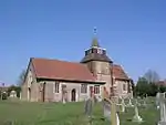 Church of St Nicholas |
| Dame Anna's Farmhouse | Norwood End, Fyfield, Epping Forest | Farmhouse | Early 16th century and earlier | 20 February 1967 | TL5645608850 51°45′23″N 0°15′55″E |
1166177 | |
| Hales Farmhouse | Norwood End, Fyfield, Epping Forest | Farmhouse | Mid 14th century | 29 June 1984 | TL5599309290 51°45′38″N 0°15′32″E |
1111318 | |
| Mashams | High Laver, Epping Forest | House | Late C16/Early 17th century | 26 April 1984 | TL5190409066 51°45′35″N 0°11′59″E |
1337579 | |
| Parish Church of All Saints | High Laver, Epping Forest | Parish Church | Late 12th century | 20 February 1967 | TL5274608673 51°45′21″N 0°12′42″E |
1123935 |  Parish Church of All Saints |
| Church of All Saints | Norton Lane, High Ongar, Epping Forest | Church | 12th century | 29 June 1984 | TL5799504587 51°43′04″N 0°17′09″E |
1111300 | 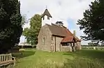 Church of All Saints |
| Norton Mandeville Manor | Norton Heath, High Ongar, Epping Forest | House | 1613 | 29 June 1984 | TL6009704415 51°42′56″N 0°18′58″E |
1146850 | 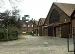 Norton Mandeville Manor |
| Abridge Motor Spares; Robert Chappell, Butcher | Abridge, Lambourne, Epping Forest | House | Late 16th century | 29 May 1984 | TQ4663196799 51°39′03″N 0°07′05″E |
1165855 | |
| Lambourne Place | Lambourne, Epping Forest | House | c. 1740 | 27 August 1952 | TQ4815197018 51°39′09″N 0°08′25″E |
1165788 | .jpg.webp) Lambourne Place |
| Parish Church of St Mary and All Saints | Lambourne, Epping Forest | Parish Church | 12th century | 20 February 1967 | TQ4785996093 51°38′39″N 0°08′08″E |
1165797 | 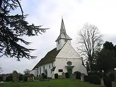 Parish Church of St Mary and All Saints |
| Church of St Mary | Little Laver, Epping Forest | Parish Church | 14th century | 20 February 1967 | TL5448609649 51°45′51″N 0°14′14″E |
1337240 | 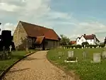 Church of St Mary |
| Little Laver Grange | Little Laver, Epping Forest | House | 16th century | 27 August 1957 | TL5453309660 51°45′51″N 0°14′17″E |
1111307 | Little Laver Grange |
| The Warren | Epping New Rd, Loughton, Epping Forest | House | Early 19th century | 29 May 1984 | TQ4098195665 51°38′32″N 0°02′10″E |
1165605 | |
| Bushes Farmhouse | Magdalen Laver, Epping Forest | Farmhouse | c. 1500 | 22 February 1952 | TL5257407923 51°44′57″N 0°12′32″E |
1123942 | 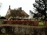 Bushes Farmhouse |
| Parish Church of St Mary Magdalen | Magdalen Laver, Epping Forest | Church | Roman | 20 February 1967 | TL5130408283 51°45′10″N 0°11′26″E |
1123945 | 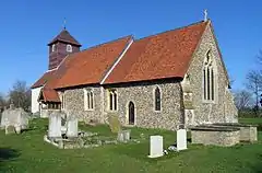 Parish Church of St Mary Magdalen |
| Weald Lodge | Magdalen Laver, Epping Forest | Farmhouse | Early 19th century | 22 July 1981 | TL5154807284 51°44′38″N 0°11′37″E |
1309169 | |
| Wynters Armourie | Magdalen Laver, Epping Forest | House | 16th century | 22 February 1952 | TL4988008174 51°45′08″N 0°10′12″E |
1165903 | 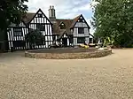 Wynters Armourie |
| Matching Hall | Matching, Epping Forest | Cross Wing House | 15th century | 22 February 1952 | TL5253811906 51°47′06″N 0°12′36″E |
1337571 | 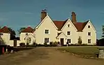 Matching Hall |
| Moat House | Matching Green, Matching, Epping Forest | House | Late 16th century | 26 April 1984 | TL5365911276 51°46′45″N 0°13′34″E |
1123926 | |
| Parish Church of St Mary | Matching, Epping Forest | Parish Church | Early 13th century | 20 February 1967 | TL5251911960 51°47′08″N 0°12′35″E |
1166182 | .jpg.webp) Parish Church of St Mary |
| The Marriage Feast Room | Matching, Epping Forest | Marriage Feast House | C15/C16 | 22 February 1952 | TL5249111951 51°47′08″N 0°12′34″E |
1166130 | 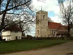 The Marriage Feast Room |
| Church of St Mary the Virgin | Moreton, Epping Forest | Parish Church | 13th century | 20 February 1967 | TL5374207038 51°44′27″N 0°13′31″E |
1168371 | 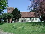 Church of St Mary the Virgin |
| Barn 20 Metres South of Greenleaves | Nazeing, Epping Forest | Barn | Early 15th century | 4 July 1984 | TL4000206340 51°44′18″N 0°01′34″E |
1111139 | |
| Dormers | Nazeing, Epping Forest | House | Late 16th century | 22 February 1952 | TL4025605565 51°43′53″N 0°01′46″E |
1111143 | |
| Greenleaves | Nazeing, Epping Forest | House | 16th century | 22 February 1952 | TL3999106358 51°44′18″N 0°01′34″E |
1337294 | |
| Old House | Nazeing, Epping Forest | Timber Framed House | Late 16th century | 4 July 1984 | TL4179606211 51°44′12″N 0°03′08″E |
1111136 | |
| Latton Priory | North Weald Bassett, Epping Forest | Augustinian Monastery | Abandoned by 1534 | 26 April 1984 | TL4657906558 51°44′19″N 0°07′17″E |
1111392 | |
| Paris Hall | North Weald Bassett, Epping Forest | House | 19th century | 22 February 1952 | TL4878207193 51°44′37″N 0°09′13″E |
1146700 | |
| Parish Church of St Andrew | North Weald Bassett, Epping Forest | Parish Church | c. 1330 | 20 February 1967 | TL4954905187 51°43′32″N 0°09′50″E |
1111353 | 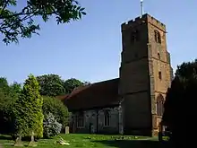 Parish Church of St Andrew |
| Sewalds Hall Farmhouse | North Weald Bassett, Epping Forest | Farmhouse | 15th century | 26 April 1984 | TL4957507408 51°44′43″N 0°09′55″E |
1146628 | |
| Greensted Hall | Greensted, Ongar, Epping Forest | Hall House | Medieval | 11 April 1984 | TL5389503053 51°42′18″N 0°13′33″E |
1337500 | |
| Marden Ash House | Marden Ash, Ongar, Epping Forest | House | Late 17th century | 11 April 1984 | TL5511002011 51°41′44″N 0°14′34″E |
1124047 | |
| Newhouse Farmhouse | Marden Ash, Ongar, Epping Forest | Farmhouse | c. 1600 | 11 April 1984 | TL5558502180 51°41′49″N 0°14′59″E |
1337514 | |
| Shelley Hall | Shelley, Ongar, Epping Forest | Hall House | Early 14th century | 11 April 1984 | TL5532805034 51°43′21″N 0°14′51″E |
1337516 | 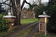 Shelley Hall |
| Barn 100 Metres East of Netherhall Farmhouse | Roydon, Epping Forest | Aisled Barn | Mid 14th century | 11 January 1979 | TL3980908254 51°45′20″N 0°01′27″E |
1182232 | |
| Garden Wall at Netherhall | Roydon, Epping Forest | Garden Wall | early-mid 15th century | 4 July 1984 | TL3981608306 51°45′22″N 0°01′27″E |
1111123 | |
| Netherhall Farmhouse | Roydon, Epping Forest | House | 15th century | 22 February 1952 | TL3974808238 51°45′19″N 0°01′24″E |
1111122 | |
| Aylmers | Sheering, Epping Forest | Farmhouse | 20th century | 22 February 1952 | TL4892112927 51°47′43″N 0°09′29″E |
1147128 | .jpg.webp) Aylmers |
| Daubneys Farmhouse | Sheering, Epping Forest | Farmhouse | Mid 16th century | 26 April 1984 | TL5083614061 51°48′17″N 0°11′11″E |
1111369 | |
| Durrington Hall | Sheering, Epping Forest | Country House | Mid-18th century | 20 February 1967 | TL4898013061 51°47′47″N 0°09′32″E |
1111363 | |
| Sheering Hall | Sheering, Epping Forest | House | 19th and 20th centuries | 22 February 1952 | TL4962012882 51°47′40″N 0°10′05″E |
1337229 | .jpg.webp) Sheering Hall |
| Church of St Margaret of Antioch | Stanford Rivers, Epping Forest | Parish Church | 12th century | 20 February 1967 | TL5341600881 51°41′09″N 0°13′04″E |
1337534 | 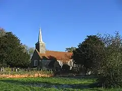 Church of St Margaret of Antioch |
| Littlebury | Stanford Rivers, Epping Forest | Timber Framed House | Late Medieval | 27 August 1952 | TL5511601179 51°41′17″N 0°14′33″E |
1306771 | 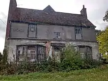 Littlebury |
| Bons Farmhouse | Stapleford Abbotts, Epping Forest | Farmhouse | 15th century | 27 August 1952 | TQ5030496787 51°38′59″N 0°10′16″E |
1337304 | |
| Church of St Mary | Stapleford Tawney, Epping Forest | Parish Church | c. 1220 | 20 February 1967 | TQ5028899018 51°40′11″N 0°10′19″E |
1124008 | Jul2006.jpg.webp) Church of St Mary |
| The Old Rectory | Stapleford Tawney, Epping Forest | House | 13th century | 27 August 1952 | TQ5038099472 51°40′26″N 0°10′24″E |
1169231 | |
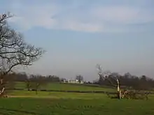
| Gaynes Park | Theydon Garnon, Epping Forest | House | Medieval | 11 April 1984 | TL4844801780 51°41′43″N 0°08′47″E |
1123952 | 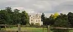 Gaynes Park |
| Abbey Gateway | Waltham Abbey, Epping Forest | Gateway | Mid 14th century | 26 January 1956 | TL3808300737 51°41′18″N 0°00′14″W |
1124156 | 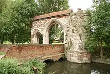 Abbey Gateway |
| Church of St Thomas | Waltham Abbey, Epping Forest | Church | 1901-1902 | 22 March 1974 | TL4157101001 51°41′24″N 0°02′48″E |
1169564 | 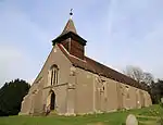 Church of St Thomas |
| Essex House | Waltham Abbey, Epping Forest | House | 1722 | 26 January 1956 | TL3849300360 51°41′06″N 0°00′07″E |
1306335 | |
| Hollyfield Hall Farmhouse | Holyfield, Waltham Abbey, Epping Forest | Farmhouse | c. 1560 | 22 March 1974 | TL3837003977 51°43′03″N 0°00′06″E |
1124131 | |
| Luthers | Waltham Abbey, Epping Forest | House | Early 19th century | 22 March 1974 | TQ3805897242 51°39′25″N 0°00′20″W |
1124102 | |
| Midnight Chapel | Waltham Abbey, Epping Forest | Chapel | Late 12th century | 26 January 1956 | TL3817700704 51°41′17″N 0°00′09″W |
1337453 | |
| Ministry of Defence Building L148 (group G Incorporating Mills) | Royal Gunpowder Factory, Waltham Abbey, Epping Forest | Gunpowder Works | c1898-99 | 26 November 1993 | TL3768901284 51°41′36″N 0°00′33″W |
1262902 | |
| Ministry of Defence Building L149 (group E Incorporating Mills) | Royal Gunpowder Factory, Waltham Abbey, Epping Forest | Wall | c. 1869 | 26 November 1993 | TL3774301289 51°41′36″N 0°00′31″W |
1251161 | |
| Ministry of Defence Building L153 (group D Incorporating Mills) | Royal Gunpowder Factory, Waltham Abbey, Epping Forest | Gunpowder Works | 1867-8 | 26 November 1993 | TL3771001232 51°41′35″N 0°00′32″W |
1251162 | |
| Ministry of Defence Building Numbers L176 (boiler House) and L177 | Royal Gunpowder Factory, Waltham Abbey, Epping Forest | Gunpowder Works | 1857 | 26 November 1993 | TL3773401026 51°41′28″N 0°00′31″W |
1329390 | |
| Ministry of Defence Buildings A201 and A202 at Tl 3768800948 | Royal Gunpowder Factory, Waltham Abbey, Epping Forest | Gunpowder Works | 1787-1800 | 26 November 1993 | TL3768800948 51°41′25″N 0°00′34″W |
1251016 | |
| Ministry of Defence Number L168 (engine House and Mechanics' Shop) | Royal Gunpowder Factory, Waltham Abbey, Epping Forest | Gunpowder Works | 1857 | 26 November 1993 | TL3771801050 51°41′29″N 0°00′32″W |
1251159 | |
| Waltham Abbey Vicarage | Waltham Abbey, Epping Forest | Vicarage | Late 16th century or early 17th century | 3 February 1971 | TL3808700666 51°41′16″N 0°00′14″W |
1124127 | 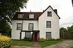 Waltham Abbey Vicarage |
| Gateway and East and West Lodges to London Entrance Drive to Copped Hall | Waltham Abbey, Epping Forest | Gate & Lodges | c. 1775 | 3 February 1971 | TL4305600480 51°41′06″N 0°04′05″E |
1124120 |  Gateway and East and West Lodges to London Entrance Drive to Copped Hall |
| 1 Sun Street | Waltham Abbey, Epping Forest | Timber Framed House | 16th century | 26 January 1956 | TL3818100554 51°41′12″N 0°00′09″W |
1169858 | |
| 41 Sun Street | Waltham Abbey, Epping Forest | House | 18th century | 25 October 1973 | TL3837600545 51°41′12″N 0°00′01″E |
1169920 | |
| 31 Highbridge Street | Waltham Abbey, Epping Forest | House | Early to mid 18th century | 26 January 1956 | TL3793600598 51°41′14″N 0°00′22″W |
1337477 | .jpg.webp) 31 Highbridge Street |
| St Andrew's Church, Willingale | Willingale, Epping Forest | Parish Church | 12th century | 20 February 1967 | TL5962507313 51°44′30″N 0°18′38″E |
1169175 | |
| Dukes Farmhouse | Willingale, Epping Forest | Farmhouse | c. 1400 | 27 August 1957 | TL5944207948 51°44′51″N 0°18′30″E |
1337269 | |
| Parish Church of St Christopher | Willingale Doe, Willingale, Epping Forest | Parish Church | Late 14th century | 20 February 1967 | TL5962607370 51°44′32″N 0°18′38″E |
1111257 | 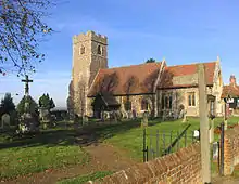 Parish Church of St Christopher |
| Tilehouse Farm | Birds Green, Willingale, Epping Forest | Farmhouse | 15th century | 29 June 1984 | TL5867608822 51°45′20″N 0°17′51″E |
1111243 | |
| Torrells Hall | Willingale, Epping Forest | House | Late 16th century | 27 August 1957 | TL6007808275 51°45′01″N 0°19′03″E |
1111249 | 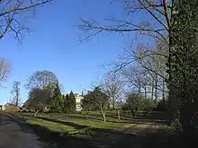 Torrells Hall |
Notes
- The date given is the date used by Historic England as significant for the initial building or that of an important part in the structure's description.
- Sometimes known as OSGB36, the grid reference is based on the British national grid reference system used by the Ordnance Survey.
- The "List Entry Number" is a unique number assigned to each listed building and scheduled monument by Historic England.
External links
![]() Media related to Grade II* listed buildings in Essex at Wikimedia Commons
Media related to Grade II* listed buildings in Essex at Wikimedia Commons
This article is issued from Wikipedia. The text is licensed under Creative Commons - Attribution - Sharealike. Additional terms may apply for the media files.