Grade II* listed buildings in Forest of Dean
There are over 20,000 Grade II* listed buildings in England. This page is a list of these buildings in the district of Forest of Dean in Gloucestershire.
Forest of Dean
| Name | Location | Type | Completed [note 1] | Date designated | Grid ref.[note 2] Geo-coordinates |
Entry number [note 3] | Image |
|---|---|---|---|---|---|---|---|
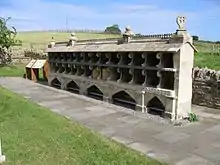
| Blakeney United Reformed Church | Blakeney, Awre, Forest of Dean | Schoolroom | 1849 | 25 January 1985 | SO6686607026 51°45′39″N 2°28′53″W |
1186386 | 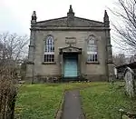 Blakeney United Reformed Church |
| Drakes House | Gatcombe, Awre, Forest of Dean | House | 17th century | 25 January 1985 | SO6795905443 51°44′48″N 2°27′56″W |
1299206 | 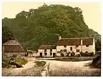 Drakes House |
| Fieldhouse | Awre, Forest of Dean | Farmhouse | Medieval | 25 January 1985 | SO6991808191 51°46′18″N 2°26′15″W |
1186367 |  |
| Guy Hall Farmhouse | Awre, Forest of Dean | Farmhouse | 16th century or earlier | 25 January 1985 | SO7050208481 51°46′27″N 2°25′44″W |
1186400 | |
| Hagloe House | Hagloe, Awre, Forest of Dean | House | Early 18th century | 25 January 1985 | SO6862406375 51°45′19″N 2°27′21″W |
1299207 | 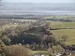 Hagloe House |
| Oaklands Park | Oaklands Park, Awre, Forest of Dean | Country House | c. 1830 | 25 January 1985 | SO6787909434 51°46′58″N 2°28′01″W |
1186363 | 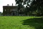 Oaklands Park |
| Market Cross | Aylburton, Forest of Dean | Market Cross | 14th century | 7 March 1988 | SO6172401788 51°42′49″N 2°33′19″W |
1186583 | 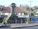 Market Cross |
| Blaisdon Hall | Blaisdon, Forest of Dean | House | 1876 | 4 July 1985 | SO6980416975 51°51′02″N 2°26′23″W |
1121880 | |
| Church of St Mary the Virgin | Flaxley, Blaisdon, Forest of Dean | Parish Church | 1856 | 4 July 1985 | SO6884915338 51°50′09″N 2°27′13″W |
1186458 | 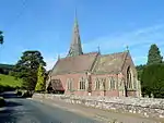 Church of St Mary the Virgin |
| Bromsberrow Place | Bromsberrow, Forest of Dean | Farmhouse | Third Quarter 18th century | 2 October 1954 | SO7571234275 52°00′23″N 2°21′19″W |
1341928 | |
| Church of St Mary | Bromsberrow, Forest of Dean | Parish Church | 13th century | 2 October 1954 | SO7422433669 52°00′03″N 2°22′37″W |
1303740 | 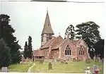 Church of St Mary |
| Church of St Andrew | Churcham, Forest of Dean | Parish Church | 12th century | 23 September 1955 | SO7685918204 51°51′43″N 2°20′15″W |
1305341 |  Church of St Andrew |
| Old Farmhouse | Coleford, Forest of Dean | Farmhouse | Late 15th century | 24 September 1984 | SO5595810476 51°47′28″N 2°38′24″W |
1186303 | |
| Corse Court | Corse, Forest of Dean | Farmhouse | 14th century | 2 October 1954 | SO7880326468 51°56′11″N 2°18′35″W |
1341953 |  Corse Court |
| Pound Farmhouse | Tillers Green, Dymock, Forest of Dean | Farmhouse | First half 17th century | 2 October 1954 | SO6965432530 51°59′25″N 2°26′36″W |
1155980 | |
| Preston Court | Preston, Dymock, Forest of Dean | Country House | Late 16th century or very early 17th century | 2 October 1954 | SO6794634583 52°00′31″N 2°28′06″W |
1303085 | 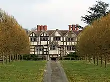 Preston Court |
| Smith Monument, in the Churchyard, about 4m west of South Porch, Church of St Mary | Dymock, Forest of Dean | Chest Tomb | 1746 | 17 March 1987 | SO7003031223 51°58′43″N 2°26′16″W |
1078510 | |
| Bee Shelter approx. 50m East of St Mary the Virgin | Hartpury, Forest of Dean | Shelter | 1847-1852 | 18 October 1985 | SO7895622990 51°54′18″N 2°18′26″W |
1341879 | |
| Hartpury House | Hartpury, Forest of Dean | Country House/College | Early 19th century | 18 October 1985 | SO7875922982 51°54′18″N 2°18′37″W |
1305312 | 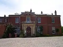 Hartpury House |
| Sloper Monument, in the Churchyard, about 21m north of West End of the Chancel, Church of St Mary | Hartpury, Forest of Dean | Chest Tomb | 1703 | 18 October 1985 | SO7806723668 51°54′40″N 2°19′13″W |
1172175 | 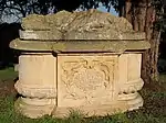 Sloper Monument, in the Churchyard, about 21m north of West End of the Chancel, Church of St Mary |
| The Hill | Hartpury, Forest of Dean | House | 17th century | 18 October 1985 | SO7789225831 51°55′50″N 2°19′23″W |
1078662 | |
| Tithe Barn, Hartpury Court | Hartpury, Forest of Dean | Barn | Mid 19th century | 2 October 1954 | SO7798523642 51°54′39″N 2°19′17″W |
1172209 | 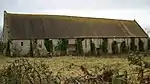 Tithe Barn, Hartpury Court |
| Church of St Mary Magdalen | Hewelsfield General, Hewelsfield and Brockweir, Forest of Dean | Anglican Church | 12th century | 7 August 1954 | SO5676002135 51°42′59″N 2°37′38″W |
1186584 |  Church of St Mary Magdalen |
| Malt House | Brockweir, Hewelsfield and Brockweir, Forest of Dean | House | 1988 | 7 August 1954 | SO5398001141 51°42′26″N 2°40′03″W |
1186590 | |
| Monument to Wife of George Geo--- in the Churchyard about 7m south of the Tower to the Church of St Mary Magdalen | Hewelsfield General, Hewelsfield and Brockweir, Forest of Dean | Chest Tomb | Late 17th century or early 18th century | 7 March 1988 | SO5676302121 51°42′58″N 2°37′38″W |
1186587 | |
| Church of St Edward the Confessor | Kempley, Forest of Dean | Chapel of Ease | 1902-3 | 17 March 1987 | SO6712829609 51°57′50″N 2°28′47″W |
1156349 | 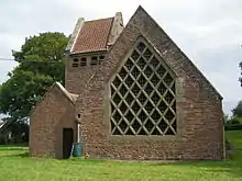 Church of St Edward the Confessor |
| Court House | Littledean, Forest of Dean | Prison | 1788-91 | 23 September 1955 | SO6732513811 51°49′19″N 2°28′32″W |
1186859 | |
| Court House, Walls and Gatehouse | Littledean, Forest of Dean | Porters Lodge | 1788-91 | 4 July 1985 | SO6732413833 51°49′20″N 2°28′32″W |
1299170 | |
| Dean Hall | Littledean, Forest of Dean | House | Earlier than 17th century | 23 September 1955 | SO6724013097 51°48′56″N 2°28′36″W |
1186495 | |
| Mill at Gun's Mills | Littledean, Forest of Dean | Blast Furnace | 1628 | 23 September 1955 | SO6751115958 51°50′29″N 2°28′23″W |
1186479 | |
| Church of All Saints | Longhope, Forest of Dean | Parish Church | 12th century | 4 July 1985 | SO6845819794 51°52′33″N 2°27′35″W |
1299178 | 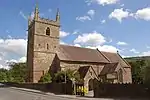 Church of All Saints |
| Sarah Siddons House (the Old House) | Lydbrook, Forest of Dean | House | Early 18th century | 12 December 1953 | SO5981116117 51°50′32″N 2°35′05″W |
1299249 | 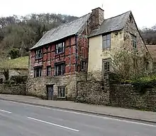 Sarah Siddons House (the Old House) |
| Monument to Dorothy Berro--- in the Churchyard About 8m north of North Corner of Aisle Chapel of the Church of St Mary | Lydney, Forest of Dean | Chest Tomb | Early 17th century | 7 March 1988 | SO6333902540 51°43′13″N 2°31′56″W |
1299110 | |
| Monument to Margerye North in the Churchyard About 22m north-east of North East Corner of Chancel of the Church of St Mary | Lydney, Forest of Dean | Chest Tomb | Early 17th century | 7 March 1988 | SO6335902556 51°43′14″N 2°31′55″W |
1186606 | |
| Naas House | Lydney, Forest of Dean | House | Early 18th century | 7 August 1954 | SO6488601769 51°42′49″N 2°30′35″W |
1186613 |  Naas House |
| Purton Manor Farmhouse | Purton, Lydney, Forest of Dean | Farmhouse | 1954 | 7 August 1954 | SO6706504525 51°44′18″N 2°28′42″W |
1186617 | |
| Unidentified Monument in the Churchyard about 12m north of Nave North Wall of the Church of St Mary | Lydney, Forest of Dean | Chest Tomb | 17th century | 7 March 1988 | SO6332002551 51°43′14″N 2°31′57″W |
1121937 | |
| Church of St Michael and All Angels | Abenhall, Mitcheldean, Forest of Dean | Parish Church | 14th century | 23 September 1955 | SO6713217429 51°51′16″N 2°28′43″W |
1299146 | 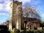 Church of St Michael and All Angels |
| International Stores | Newent, Forest of Dean | Courtyard | 15th century | 18 October 1985 | SO7225425863 51°55′50″N 2°24′18″W |
1078677 | |
| Clearwell Castle | Clearwell, Newland, Forest of Dean | Country House | 1727 | 24 September 1984 | SO5701207746 51°46′00″N 2°37′28″W |
1186324 | |
| The Old House | Newnham on Severn, Forest of Dean | Detached House | 16th century | 10 January 1955 | SO6919911973 51°48′20″N 2°26′53″W |
1101482 | |
| Church of St Anne | Oxenhall, Forest of Dean | Parish Church | 14th century | 2 October 1954 | SO7114126728 51°56′18″N 2°25′16″W |
1304818 | 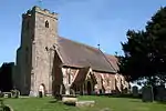 Church of St Anne |
| Crooke's Farmhouse | Oxenhall, Forest of Dean | Farmhouse | 15th century | 24 March 1976 | SO7044626071 51°55′56″N 2°25′52″W |
1078603 | |
| Bury Court Farmhouse | Redmarley D'Abitot, Forest of Dean | Farmhouse | 12th century | 2 October 1954 | SO7597332851 51°59′37″N 2°21′05″W |
1078523 | |
| Church of St John the Baptist | Ruardean, Forest of Dean | Parish Church | 12th century | 23 September 1955 | SO6211517690 51°51′23″N 2°33′05″W |
1100629 | 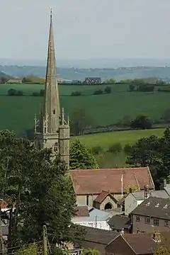 Church of St John the Baptist |
| Tithe Barn, Highleadon Court | Rudford and Highleadon, Forest of Dean | Threshing Barn | 15th century OR EARLY 16th century | 18 October 1985 | SO7701624437 51°55′05″N 2°20′08″W |
1152574 | |
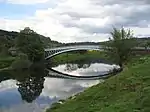
| Bigsweir Bridge | Bigsweir, St. Briavels, Forest of Dean | Road Bridge | 1826/29 | 7 March 1988 | SO5387005105 51°44′34″N 2°40′10″W |
1186622 | |
| Monument to Elizabeth Butler in the Churchyard about 3m south of the South West Corner of the South Transept to the Church | St Briavels, Forest of Dean | Chest Tomb | Mid C17 Sandstone | 7 March 1988 | SO5586804636 51°44′19″N 2°38′26″W |
1186627 | |
| Monument to James Gough in the Churchyard about 15m south of the Chancel Wall of the Church of St Mary | St Briavels Forest of Dean | Chest Tomb | Late 17th century | 7 March 1988 | SO5587304629 51°44′19″N 2°38′26″W |
1337662 | |
| Mork Farmhouse | Mork, St Briavels, Forest of Dean | Farmhouse | C16/C17 | 7 August 1954 | SO5537805595 51°44′50″N 2°38′52″W |
1186639 | |
| Church of St James | Staunton, Forest of Dean | Parish Church | 12th century | 2 October 1954 | SO7819329202 51°57′39″N 2°19′08″W |
1156776 | 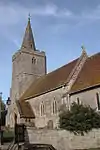 Church of St James |
| Barn at Taynton House | Taynton, Forest of Dean | Barn | 1695 | 2 October 1954 | SO7223222184 51°53′51″N 2°24′18″W |
1078575 | |
| Church of St Lawrence | Taynton, Forest of Dean | Schoolroom | 1825 | 2 October 1954 | SO7372622147 51°53′50″N 2°23′00″W |
1152696 | 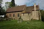 Church of St Lawrence |
| Farm Store and Cider House, North West of Taynton House | Taynton, Forest of Dean | Cider House | LATE 17th century or early 18th century | 2 October 1954 | SO7220522163 51°53′50″N 2°24′19″W |
1341921 | |
| Stables, North East of Taynton House and Wall and Wall and Gates Connecting to House | Taynton, Forest of Dean | Gate | Late 17th century or early 18th century | 2 October 1954 | SO7225722178 51°53′51″N 2°24′17″W |
1078576 | |
| Church of St Mary and St Peter | Tidenham, Forest of Dean | Anglican Church | 13th century | 7 August 1954 | ST5559195847 51°39′35″N 2°38′36″W |
1366270 |  Church of St Mary and St Peter |
| Mead Farmhouse | Sedbury, Tidenham, Forest of Dean | Farmhouse | Mid/late 18th century | 7 August 1954 | ST5492094567 51°38′53″N 2°39′11″W |
1100607 | |
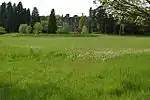
| Sedbury Park | Sedbury, Tidenham, Forest of Dean | Country House | 19th century | 7 August 1954 | ST5535193384 51°38′15″N 2°38′48″W |
1348351 | _-_geograph.org.uk_-_566204.jpg.webp) Sedbury Park |
| Stroat Farmhouse | Stroat, Tidenham, Forest of Dean | Farmhouse | c. 1600 | 7 August 1954 | ST5741897940 51°40′43″N 2°37′02″W |
1099177 | |
| Cruck Barn at Upleadon Court, to North West of House | Upleadon, Forest of Dean | Barn | 17th century | 18 October 1985 | SO7683126936 51°56′26″N 2°20′18″W |
1078589 | |
| Hayes | West Dean, Forest of Dean | Farmhouse | Late 16th century | 24 September 1984 | SO6580406102 51°45′09″N 2°29′48″W |
1186357 | |
| Church of St Peter and St Paul | Westbury-on-Severn, Forest of Dean | Church | Early 14th century | 4 July 1985 | SO7171713886 51°49′22″N 2°24′42″W |
1101724 |  Church of St Peter and St Paul |
| Monument to Daughter of William Smart in the Churchyard about 4m south-east of South East Corner of Aisle to the Church | Woolaston, Forest of Dean | Chest Tomb | 17th century | 7 March 1988 | ST5868899339 51°41′29″N 2°35′57″W |
1101489 | |
| Monument to Elizabeth Woodrofe in the Churchyard about 10m south-east of the South East Corner of the Chancel | Woolaston, Forest of Dean | Chest Tomb | Mid 17th century | 7 March 1988 | ST5870199338 51°41′29″N 2°35′56″W |
1299105 | |
| Monument to William Smart in the Churchyard about 12m south-east of the South East Corner of the Aisle of the Church | Woolaston, Forest of Dean | Chest Tomb | 1666 | 7 March 1988 | ST5868899337 51°41′29″N 2°35′57″W |
1186670 | |
Notes
- The date given is the date used by Historic England as significant for the initial building or that of an important part in the structure's description.
- Sometimes known as OSGB36, the grid reference is based on the British national grid reference system used by the Ordnance Survey.
- The "List Entry Number" is a unique number assigned to each listed building and scheduled monument by Historic England.
External links
![]() Media related to Grade II* listed buildings in Gloucestershire at Wikimedia Commons
Media related to Grade II* listed buildings in Gloucestershire at Wikimedia Commons
This article is issued from Wikipedia. The text is licensed under Creative Commons - Attribution - Sharealike. Additional terms may apply for the media files.