Grade II* listed buildings in Hastings
There are over 20,000 Grade II* listed buildings in England. This page is a list of these buildings in the district of Hastings in East Sussex.
List
| Name | Location | Type | Completed [note 1] | Date designated | Grid ref.[note 2] Geo-coordinates |
Entry number [note 3] | Image |
|---|---|---|---|---|---|---|---|
| Wellington Square Baptist Church | Hastings | Church | 1838 | 19 January 1951 | TQ8181709457 50°51′22″N 0°34′55″E |
1286663 | .JPG.webp) Wellington Square Baptist Church |
| Chapel to the Former Convent of the Holy Child Jesus | St Leonards-on-Sea, Hastings | Chapel | c. 1850 | 14 September 1976 | TQ8076109226 50°51′15″N 0°34′00″E |
1043478 | .JPG.webp) Chapel to the Former Convent of the Holy Child Jesus |
| Christ Church | Blacklands, Hastings | Church | 1878-1881 | 14 September 1976 | TQ8148610651 50°52′01″N 0°34′40″E |
1286964 | .jpg.webp) Christ Church |
| Christ Church and St Mary Magdalen | St Leonards-on-Sea, Hastings | Church | 1873 to 1875 | 14 September 1976 | TQ8024309148 50°51′14″N 0°33′34″E |
1286965 | |
| Church of All Saints | Hastings | Church | Early 15th century | 19 January 1951 | TQ8282609860 50°51′34″N 0°35′47″E |
1353127 | .JPG.webp) Church of All Saints |
| Church of All Souls | Clive Vale, Hastings | Church | 1890 | 14 September 1976 | TQ8353710768 50°52′02″N 0°36′25″E |
1293681 | |
| Church of St Clement | Hastings | Church | 19th century | 19 January 1951 | TQ8244409626 50°51′27″N 0°35′27″E |
1286732 | .jpg.webp) Church of St Clement |
| Church of St John the Evangelist | St Leonards-on-Sea, Hastings | Church | 1881 | 14 September 1976 | TQ7978509369 50°51′21″N 0°33′11″E |
1043400 | |
| Church of St Mary in the Castle | Hastings | Church | 1825-1828 | 19 January 1951 | TQ8201309415 50°51′20″N 0°35′05″E |
1353209 | .JPG.webp) Church of St Mary in the Castle |
| Church of St Matthew | Silverhill, Hastings | Church | 1884 | 14 September 1976 | TQ7992110459 50°51′56″N 0°33′20″E |
1192138 | |
| Church of St Peter | Bohemia, Hastings | Church | 1885 | 14 September 1976 | TQ8035809934 50°51′39″N 0°33′41″E |
1353235 | |
| Church of the Holy Trinity | Hastings | Church | 1851-9 | 14 September 1976 | TQ8146109340 50°51′18″N 0°34′36″E |
1043423 | |
| Crown House | St Leonards-on-Sea, Hastings | Detached House | 1828 | 19 January 1951 | TQ7976908817 50°51′03″N 0°33′09″E |
1043436 | |
| Net and Tackle Stores on Beach including Groups L to W (consecutive) | Hastings | Net House | Probably 16th century | 14 September 1976 | 49°46′01″N 7°33′26″W | 1192092 | 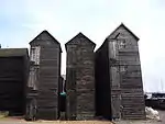 Net and Tackle Stores on Beach including Groups L to W (consecutive) |
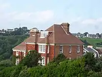
| Old Hastings House | Hastings | Country House | Early-Mid 18th century | 19 January 1951 | TQ8274609970 50°51′37″N 0°35′43″E |
1043462 | 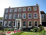 Old Hastings House |
| Pelham Arcade | Hastings | Shopping Arcade | 1823-1825 | 3 May 1988 | TQ8201609386 50°51′19″N 0°35′05″E |
1043389 | |
| Statue of Queen Anne South East of Holmhurst St Mary's School | Baldslow, Hastings | Statue | 1711-12 | 14 September 1976 | TQ8039912891 50°53′14″N 0°33′48″E |
1192060 |  |
| The Clock House | St Leonards-on-Sea, Hastings | House | 1828 | 19 January 1951 | TQ7992409053 50°51′11″N 0°33′17″E |
1043443 | .jpg.webp) The Clock House |
| The Cupola | Belmont, Hastings | Villa | c. 1835 | 14 September 1976 | TQ8302910213 50°51′45″N 0°35′58″E |
1353124 | |
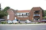
| The Stables Theatre | Hastings | House | Possibly late 17th century | 19 January 1951 | TQ8271709894 50°51′35″N 0°35′41″E |
1353194 | |
| Windycroft | High Wickham, Hastings | House | Pre 1879 | 14 September 1976 | TQ8299810001 50°51′38″N 0°35′56″E |
1043472 | |
| No. 7 and 8 Pelham Place | Hastings | House | New | 19 January 1951 | TQ8207509386 50°51′19″N 0°35′08″E |
1191986 | .jpg.webp) No. 7 and 8 Pelham Place |
| No. 1-14, 14a and 15 Pelham Crescent and 9 Pelham Place | Hastings | House | 1824-8 | 19 January 1951 | TQ8204009398 50°51′20″N 0°35′06″E |
1191926 | 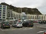 No. 1-14, 14a and 15 Pelham Crescent and 9 Pelham Place |
.JPG.webp)
.JPG.webp)
.JPG.webp)
.JPG.webp)
.JPG.webp)
.jpg.webp)
_(June_2015)_(2).jpg.webp)
Notes
- The date given is the date used by Historic England as significant for the initial building or that of an important part in the structure's description.
- Sometimes known as OSGB36, the grid reference is based on the British national grid reference system used by the Ordnance Survey.
- The "List Entry Number" is a unique number assigned to each listed building and scheduled monument by Historic England.
External links
![]() Media related to Grade II* listed buildings in East Sussex at Wikimedia Commons
Media related to Grade II* listed buildings in East Sussex at Wikimedia Commons
This article is issued from Wikipedia. The text is licensed under Creative Commons - Attribution - Sharealike. Additional terms may apply for the media files.