Grade II* listed buildings in Maidstone (borough)
There are over 20,000 Grade II* listed buildings in England. This page is a list of these buildings in the district of Maidstone in Kent.
Maidstone
| Name | Location | Type | Completed [note 1] | Date designated | Grid ref.[note 2] Geo-coordinates |
Entry number [note 3] | Image |
|---|---|---|---|---|---|---|---|
| Church of St Margaret | Barming, Maidstone | Tower | Late 14th century or early 15th century | 23 May 1967 | TQ7200854225 51°15′40″N 0°27′50″E |
1060773 | 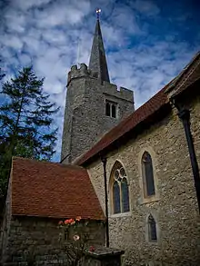 Church of St Margaret |
| Church of St James | Bicknor | Church | 1859-61 | 26 April 1968 | TQ8605658821 51°17′53″N 0°40′03″E |
1185510 | 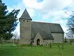 Church of St James |
| Court Lodge | Bicknor | House | Mid 17th century | 26 April 1968 | TQ8623858635 51°17′47″N 0°40′12″E |
1086227 |  |
| Church of St Nicholas | Grafty Green, Boughton Malherbe | Parish Church | 13th century | 26 April 1968 | TQ8822849553 51°12′51″N 0°41′37″E |
1060861 | 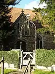 Church of St Nicholas |
| Hazel Hill Cottage | Sandway, Boughton Malherbe | Timber Framed House | c. 1400 | 2 February 1989 | TQ8948049212 51°12′38″N 0°42′41″E |
1252611 |  Hazel Hill Cottage |
| Brishing Court | Boughton Monchelsea | Farmhouse | Early 15th century | 25 July 1952 | TQ7778551451 51°14′04″N 0°32′43″E |
1344355 | |
| Church of St Peter | Boughton Monchelsea | Church | possible late 11th century or 12th century | 25 March 1987 | TQ7711549895 51°13′15″N 0°32′06″E |
1060754 | 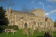 Church of St Peter |
| Elm House and attached Railings | Boughton Monchelsea | House | Early 18th century | 23 May 1967 | TQ7742051149 51°13′55″N 0°32′23″E |
1068795 | |
| Harts House | Boughton Monchelsea | House | Later | 25 July 1952 | TQ7685151851 51°14′18″N 0°31′55″E |
1060784 | |
| Hertsfield Bridges | Boughton Monchelsea | Bridge | 14th century or 15th century | 25 July 1952 | TQ7825046762 51°11′32″N 0°32′58″E |
1060786 | _-_geograph.org.uk_-_1209182.jpg.webp) Hertsfield Bridges |
| Lychgate | Boughton Monchelsea | Lych Gate | 16th century or earlier | 25 July 1952 | TQ7709449920 51°13′16″N 0°32′05″E |
1068606 | 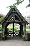 Lychgate |
| Rabbit's Cross Farmhouse | Boughton Monchelsea | Farmhouse | 15th century | 23 May 1967 | TQ7851447381 51°11′52″N 0°33′13″E |
1060770 | 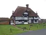 Rabbit's Cross Farmhouse |
| Rock Cottage | Boughton Monchelsea | Continuous Jetty House | Late 16th century | 23 May 1967 | TQ7686651889 51°14′20″N 0°31′56″E |
1344353 | |
| Boxley Abbey House | Boxley Abbey, Boxley | Abbey | 1146 (founded) | 20 October 1952 | TQ7610358681 51°18′00″N 0°31′29″E |
1086228 |  Boxley Abbey House |
| Parsonage Farm | Boxley | House | Early 14th century | 20 October 1952 | TQ7738858895 51°18′06″N 0°32′36″E |
1185727 | |
| St Andrew's Chapel | Boxley | Abbey | Late 15th century | 20 October 1952 | TQ7573658645 51°17′59″N 0°31′10″E |
1185580 | |
| Weavering Manor | Weavering, Boxley | Timber Framed House | Early 17th century | 13 July 1978 | TQ7838755792 51°16′24″N 0°33′22″E |
1185828 | |
| Church of St Margaret | Broomfield and Kingswood | Church | Late 11th century or 12th century | 26 April 1968 | TQ8400152495 51°14′31″N 0°38′05″E |
1060942 | 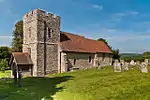 Church of St Margaret |
| Dunbury Farmhouse | Chart Sutton | Farmhouse | 14th century | 18 December 1985 | TQ7916246288 51°11′16″N 0°33′44″E |
1060947 | |
| Rugmer Hill Farmhouse | Collier Street | Farmhouse | late 14th century or early 15th century | 23 May 1967 | TQ7115048107 51°12′24″N 0°26′55″E |
1320370 | |
| Church of Saint Mary | East Farleigh | Tower | 13th century possibly earlier origins | 23 May 1967 | TQ7341453317 51°15′10″N 0°29′01″E |
1249534 |  Church of Saint Mary |
| Luckhurst | East Sutton | Farmhouse | Late 15th century or early 16th century | 26 April 1968 | TQ8327947936 51°12′04″N 0°37′19″E |
1068646 | |
| Noahs Ark Farmhouse | East Sutton | Farmhouse | 14th century or early 15th century | 18 December 1985 | TQ8246746694 51°11′25″N 0°36′35″E |
1356139 | |
| Parsonage Farmhouse | East Sutton | Farmhouse | Early to mid 15th century | 26 April 1968 | TQ8331349287 51°12′48″N 0°37′24″E |
1356171 |  Parsonage Farmhouse |
| The Blue House | East Sutton | House | Early 17th century | 26 April 1968 | TQ8317850251 51°13′19″N 0°37′18″E |
1344269 | |
| Walnut Tree Cottage | East Sutton | House | Late C16/early 17th century | 18 December 1985 | TQ8375149379 51°12′51″N 0°37′46″E |
1060930 | |
| Church of St Dunstan | Frinsted | Parish Church | 12th century | 26 April 1968 | TQ8917257403 51°17′04″N 0°42′41″E |
1336286 | 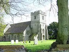 Church of St Dunstan |
| Yokes Court | Frinsted | House | Early 17th century | 26 April 1968 | TQ8996056532 51°16′35″N 0°43′20″E |
1336287 | 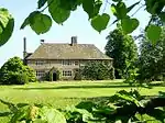 Yokes Court |
| Gazebo cum Boathouse at TQ 872 529 | Harrietsham | Boat House | 1st half of 18th century | 26 April 1968 | TQ8711452953 51°14′42″N 0°40′46″E |
1185158 | |
| Greenway Forstal Farmhouse | Greenway Forstal, Harrietsham | Farmhouse | late 16th century or early 17th century | 26 April 1968 | TQ8513253415 51°14′59″N 0°39′05″E |
1299691 | 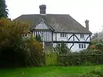 Greenway Forstal Farmhouse |
| Harrietsham Manor | Stede Hill, Harrietsham | House | Late 16th century | 14 December 1984 | TQ8785054210 51°15′22″N 0°41′26″E |
1086156 | 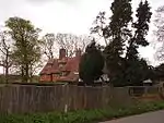 Harrietsham Manor |
| Cloth Hall | Headcorn | Cloth Hall | Late C15-Early 16th century | 20 October 1986 | TQ8329544254 51°10′05″N 0°37′13″E |
1344312 | 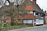 Cloth Hall |
| Headcorn Manor | Headcorn | House | C20 | 20 October 1952 | TQ8312944229 51°10′05″N 0°37′05″E |
1060835 | |
| Kelsham Farmhouse | Hawkenbury | Farmhouse | 17th century | 26 April 1968 | TQ8145044385 51°10′12″N 0°35′39″E |
1060838 | |
| Godfrey House | Hollingbourne | Timber Framed House | Late 16th century | 20 October 1952 | TQ8376254773 51°15′45″N 0°37′57″E |
1054873 | 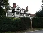 Godfrey House |
| Malt House | Hollingbourne | House | 1986 | 20 October 1952 | TQ8446655336 51°16′02″N 0°38′34″E |
1344363 | 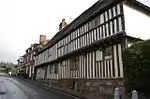 Malt House |
| Barn about 50 Metres South East of Buston Manor | Hunton | Barn | Late 14th century | 23 May 1967 | TQ7134650908 51°13′54″N 0°27′10″E |
1249915 | 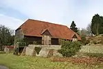 Barn about 50 Metres South East of Buston Manor |
| Buston Manor | Hunton | House | Late 17th century addition | 25 July 1952 | TQ7129050959 51°13′56″N 0°27′07″E |
1249912 | 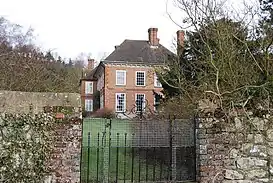 Buston Manor |
| Granary About 40 Metres South East of Buston Manor | Hunton | Granary | Later 16th century or early 17th century | 23 May 1967 | TQ7133850921 51°13′54″N 0°27′10″E |
1249914 | |
| Stonewall Farmhouse Mounting Block and Garden Wall to East | Hunton | House | Late 16th century | 25 July 1952 | TQ7291448954 51°12′49″N 0°28′28″E |
1249763 | |
| Church of St Mary | Langley | Church | 1853-1855 | 18 December 1985 | TQ8052251503 51°14′03″N 0°35′04″E |
1060898 | 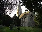 Church of St Mary |
| Langley Corner Farmhouse | Langley | Farmhouse | 15th century | 20 October 1952 | TQ8094251816 51°14′13″N 0°35′26″E |
1068799 | 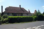 Langley Corner Farmhouse |
| Battel Hall | Leeds | Hall House | second quarter 14th century | 20 October 1952 | TQ8276953308 51°14′59″N 0°37′03″E |
1336303 |  Battel Hall |
| Cordwainers | Leeds | Cross Passage House | 15th century | 26 April 1968 | TQ8099553622 51°15′11″N 0°35′32″E |
1185805 | |
| Manor House | Leeds | House | 19th century | 20 October 1952 | TQ8233053165 51°14′55″N 0°36′40″E |
1336304 |  Manor House |
| Vineys Cottages | Leeds | House | Mid 16th century | 20 October 1952 | TQ8195152621 51°14′37″N 0°36′20″E |
1336310 | 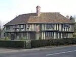 Vineys Cottages |
| Corner House, Lenham; Greengrocers, Rebecca's Antiques and Furnishings | Lenham | House | 1984 | 20 October 1952 | TQ8986752214 51°14′15″N 0°43′07″E |
1060957 | 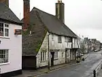 Corner House, Lenham; Greengrocers, Rebecca's Antiques and Furnishings |
| Forge House | Lenham | House | 1952 | 20 October 1952 | TQ8996152155 51°14′13″N 0°43′11″E |
1060992 | .jpg.webp) Forge House |
| Honeywood | Lenham | Jettied House | 1621 | 20 October 1952 | TQ8968952047 51°14′10″N 0°42′57″E |
1060976 | 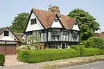 Honeywood |
| Lenham Court | Lenham | House | Late 16th century | 14 December 1984 | TQ8841851992 51°14′10″N 0°41′52″E |
1116246 |  Lenham Court |
| Royton Manor | Lenham Heath, Lenham | House | late 16th century or early 17th century | 26 April 1968 | TQ9038850340 51°13′14″N 0°43′30″E |
1060984 | |
| 14, 15 and 16, The Square | Lenham | House | Early 18th century | 20 October 1952 | TQ8992052178 51°14′14″N 0°43′09″E |
1060960 | 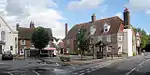 14, 15 and 16, The Square |
| Church of St Nicholas | Linton | Tower | 1860 | 23 May 1967 | TQ7545650144 51°13′25″N 0°30′41″E |
1250235 | 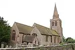 Church of St Nicholas |
| Church of All Saints | Loose | Church | 13th century | 23 May 1967 | TQ7571752083 51°14′27″N 0°30′57″E |
1263275 | 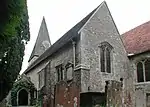 Church of All Saints |
| The Wool House and Garden Wall to North and East | Loose | House | Restored 1920s | 25 July 1952 | TQ7558552090 51°14′27″N 0°30′51″E |
1263154 | 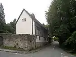 The Wool House and Garden Wall to North and East |
| Chainhurst Farmhouse | Marden | Farmhouse | Late 16th century | 23 May 1967 | TQ7309447947 51°12′16″N 0°28′35″E |
1060663 | |
| Great Cheveney House | Marden | Continuous Jetty House | Late 15th century or Early 16th century | 23 May 1967 | TQ7357842234 51°09′11″N 0°28′50″E |
1055805 | |
| White Lyon House | Marden | House | late 16th century or early 17th century | 23 May 1967 | TQ7459744593 51°10′26″N 0°29′47″E |
1345537 | |
| Gore Court | Otham | Kitchen | Late 16th century or early 17th century | 25 July 1952 | TQ7906253261 51°15′01″N 0°33′52″E |
1250699 | |
| Stoneacre and Path between Front Door and Road | Otham | Farmhouse | Formerly | 25 July 1952 | TQ7998053494 51°15′08″N 0°34′40″E |
1250995 | |
| Church of St Lawrence | Otterden | Parish Church | 1753-59 | 26 April 1968 | TQ9473154184 51°15′13″N 0°47′21″E |
1060964 | 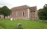 Church of St Lawrence |
| Otterden Place, and Donkey Wheel attached | Otterden | Country House | Mid 16th century | 20 October 1952 | TQ9466854202 51°15′13″N 0°47′18″E |
1115729 | 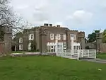 Otterden Place, and Donkey Wheel attached |
| Exhurst | Staplehurst | Farmhouse | late 14th century or early 15th century | 25 March 1987 | TQ7984642963 51°09′28″N 0°34′14″E |
1060748 | |
| Hush Heath Manor | Staplehurst | Continuous Jetty House | Early 17th century | 25 July 1952 | TQ7573040835 51°08′23″N 0°30′38″E |
1045800 | 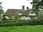 Hush Heath Manor |
| Little Harts Heath | Staplehurst | Wealden House | 15th century or early 16th century | 23 May 1967 | TQ7550041190 51°08′35″N 0°30′27″E |
1060730 | 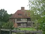 Little Harts Heath |
| Loddenden Manor | Staplehurst | Continuous Jetty House | Mid-Late 16th century | 25 July 1952 | TQ7867643368 51°09′42″N 0°33′14″E |
1040054 | |
| Barham Court | Teston | House | 1932-1933 | 25 July 1952 | TQ7068453661 51°15′24″N 0°26′41″E |
1251014 | |
| Church of St Peter and St Paul | Teston | Tower | Pre 1736 | 23 May 1967 | TQ7055153506 51°15′19″N 0°26′34″E |
1251097 | |
| Abbey Gate Farmhouse | Tovil | Larder | 15th century to 16th century | 30 July 1951 | TQ7526053653 51°15′18″N 0°30′37″E |
1086289 | |
| Bydews Place | Tovil | House | 17th century | 30 July 1951 | TQ7484154296 51°15′40″N 0°30′16″E |
1075786 | |
| Hayle Mill | Tovil, Maidstone | Mill House | c. 1800 | 2 August 1974 | TQ7559553870 51°15′25″N 0°30′54″E |
1267535 | 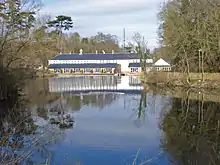 Hayle Mill |
| Kingsnorth Manor Farmhouse | Ulcombe, Maidstone | Farmhouse | Late 16th century | 26 April 1968 | TQ8485147535 51°11′50″N 0°38′40″E |
1344290 | 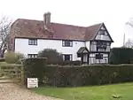 Kingsnorth Manor Farmhouse |
| Benover House | Yalding | Farmhouse | early to mid 16th century | 23 May 1967 | TQ7046048245 51°12′29″N 0°26′20″E |
1060629 | |
| Burnt Oak | Yalding | House | C20 | 23 May 1967 | TQ7011348684 51°12′43″N 0°26′03″E |
1344428 | |
| Church House | Yalding | House | 1987 | 23 May 1967 | TQ6986050113 51°13′30″N 0°25′52″E |
1344038 | 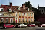 Church House |
| Court Lodge and the Dairy House | Yalding | Farmhouse | Late 17th century | 25 July 1952 | TQ6985550207 51°13′33″N 0°25′52″E |
1069066 | 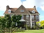 Court Lodge and the Dairy House |
| Downs Farm House | Yalding | Farmhouse | 14th century or early 15th century | 23 May 1967 | TQ6991250359 51°13′38″N 0°25′55″E |
1348345 | |
| Nightingale Farmhouse | Yalding | Farmhouse | 14th century or early 15th century | 14 October 1987 | TQ6983149231 51°13′01″N 0°25′49″E |
1060627 | |
| Rose Cottages | Yalding | Farmhouse | 14th century or early 15th century | 23 May 1967 | TQ6997550252 51°13′34″N 0°25′58″E |
1348526 | 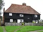 Rose Cottages |
| The Normans | Benover, Yalding | Continuous Jetty House | late 16th century early 17th century | 13 May 1967 | TQ7004348738 51°12′45″N 0°25′59″E |
1115396 | 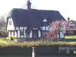 The Normans |
| Barming Place | Maidstone | House | Mid 18th century | 30 July 1951 | TQ7287954663 51°15′54″N 0°28′36″E |
1086294 | |
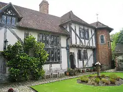
| Chillington House, Maidstone Museum & Art Gallery | Maidstone | House | 1561 | 30 July 1951 | TQ7589556005 51°16′34″N 0°31′14″E |
1222803 | 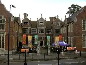 Chillington House, Maidstone Museum & Art Gallery |
| Farm Cottages | Maidstone | Wealden House | 15th century | 30 July 1951 | TQ7791554183 51°15′33″N 0°32′54″E |
1266343 | 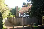 Farm Cottages |
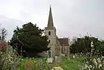
| Former Church of St Peter | Maidstone | Church | Converted to secular use | 30 July 1951 | TQ7559855633 51°16′22″N 0°30′58″E |
1086281 | 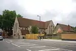 Former Church of St Peter |
| Grove House | Maidstone | House | 18th century | 30 July 1951 | TQ7603056192 51°16′40″N 0°31′21″E |
1266232 | |
| Little Buckland Farm Cottage | Maidstone | End Jetty House | 14th century | 30 July 1951 | TQ7507456732 51°16′58″N 0°30′32″E |
1086397 | |
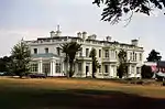
| Mote House | Mote Park, Maidstone | Country House | 1793 and 1801 | 30 July 1951 | TQ7809554991 51°15′58″N 0°33′05″E |
1086313 | 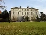 Mote House |
| Officers Quarters, Maidstone Former Cavalry Barracks | Maidstone | Officers Mess | c1797-1798 | 2 August 1974 | TQ7580856440 51°16′48″N 0°31′10″E |
1225271 | |
| Park House | Maidstone | House | 1792 | 2 August 1974 | TQ7587757468 51°17′21″N 0°31′15″E |
1086363 | 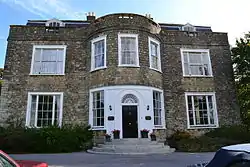 Park House |
| Romney House | Maidstone | House | Early 18th century | 30 July 1951 | TQ7625555544 51°16′18″N 0°31′31″E |
1086274 | 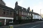 Romney House |
| Stone House or the Judges Lodgings | Maidstone | House | Early 18th century | 30 July 1951 | TQ7621755517 51°16′18″N 0°31′29″E |
1224677 | 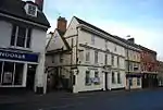 Stone House or the Judges Lodgings |
| The College | Maidstone | Teachers House | 14th century | 30 July 1951 | TQ7600955346 51°16′12″N 0°31′18″E |
1225072 | 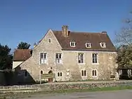 The College |
| The Corpus Christi Hall | Maidstone | Guildhall | 1549-1871 | 30 July 1951 | TQ7583055804 51°16′27″N 0°31′10″E |
1086371 | .jpg.webp) The Corpus Christi Hall |
| The Dungeons at the Archbishop's Palace | Maidstone | Cell Block | 14th century medieval | 30 July 1951 | TQ7595255414 51°16′15″N 0°31′15″E |
1086309 | |
| The Old Farmhouse | Maidstone | Farmhouse | 15th century | 2 August 1974 | TQ7558057836 51°17′33″N 0°31′01″E |
1086362 | |
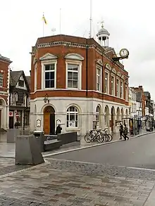
| The Town Hall | Maidstone | Cell Block | 1762-3 | 30 July 1951 | TQ7602755718 51°16′24″N 0°31′20″E |
1086305 | |
| Turkey Court | Maidstone | Managers House | Mid 18th century | 30 July 1951 | TQ7719455535 51°16′17″N 0°32′20″E |
1238987 | |
| Willington Place | Maidstone | Jettied House | 15th century | 30 July 1951 | TQ7834054050 51°15′28″N 0°33′16″E |
1266284 | 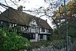 Willington Place |
| 11 Lower Stone Street | Maidstone | House | Early 18th century | 30 July 1951 | TQ7623155550 51°16′19″N 0°31′30″E |
1086332 | 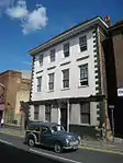 11 Lower Stone Street |
| 70 Lower Stone Street | Maidstone | Jettied House | 15th century | 30 July 1951 | TQ7624455399 51°16′14″N 0°31′30″E |
1336227 | 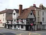 70 Lower Stone Street |
| 85 Bank Street | Maidstone | Shop | Early 19th century | 30 July 1951 | TQ7601755688 51°16′23″N 0°31′19″E |
1086357 | 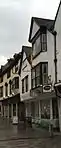 85 Bank Street |
| 8 and 9 High Street | Maidstone | Wetherspoons | 1827 | 30 July 1951 | TQ7603255757 51°16′26″N 0°31′20″E |
1223181 | 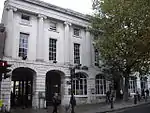 8 and 9 High Street |
| 78 Bank Street | Maidstone | House | 18th century | 30 July 1951 | TQ7598855669 51°16′23″N 0°31′18″E |
1266847 | |
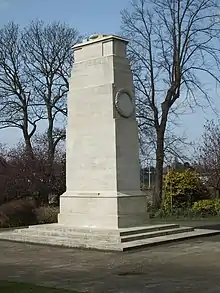
| The Queen's Own Royal West Kent Regiment Cenotaph | Brenchley Gardens, Maidstone | War memorial | 1921 | 2 August 1974 | TQ7588756128 51°16′38″N 0°31′13″E |
1086395 | |
| Mansion Farmhouse | Ulcombe | House | 17th century | 26 April 1968 | TQ8585048954 51°12′34″N 0°39′34″E |
1060889 | |
Notes
- The date given is the date used by Historic England as significant for the initial building or that of an important part in the structure's description.
- Sometimes known as OSGB36, the grid reference is based on the British national grid reference system used by the Ordnance Survey.
- The "List Entry Number" is a unique number assigned to each listed building and scheduled monument by Historic England.
External links
![]() Media related to Grade II* listed buildings in Kent at Wikimedia Commons
Media related to Grade II* listed buildings in Kent at Wikimedia Commons
This article is issued from Wikipedia. The text is licensed under Creative Commons - Attribution - Sharealike. Additional terms may apply for the media files.