Grade II* listed buildings in Norwich
There are over 20,000 Grade II* listed buildings in England. This page is a list of these buildings in the city of Norwich in the county of Norfolk.
Buildings
| Name | Location | Type | Completed [note 1] | Date designated | Grid ref.[note 2] Geo-coordinates |
Entry number [note 3] | Image |
|---|---|---|---|---|---|---|---|
| Augustine Steward's House | Norwich | House | 17th century | 26 February 1954 | TG2332108860 52°37′53″N 1°17′55″E |
1372527 | 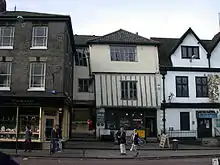 Augustine Steward's House |
| Henry Bacon's House, Colegate | Norwich | Apartment | 26 February 1954 | TG2303309030 52°37′59″N 1°17′40″E |
1051320 | 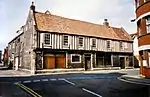 Henry Bacon's House, Colegate | |
| Bethel Hospital | Norwich | Psychiatric Hospital | C17/early C18 | 8 April 1986 | TG2272108455 52°37′41″N 1°17′22″E |
1051362 |  |
| Bishop Bridge | Norwich | Bridge | c. 1340 | 26 February 1954 | TG2399308991 52°37′57″N 1°18′31″E |
1205642 | 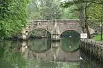 Bishop Bridge |
| Bishop Renold's Chapel (Bishop Reynolds Chapel) |
Norwich | Library | 26 February 1954 | TG2349208987 52°37′57″N 1°18′04″E |
1206255 | | |
| Bishop Salmon's Porch | Norwich | Great Hall | Early 14th century | 26 February 1954 | TG2350109018 52°37′58″N 1°18′05″E |
1051329 | |
| Church of St Andrew | Eaton, Norfolk | Church | 15th century | 26 February 1954 | TG2025405966 52°36′24″N 1°15′05″E |
1206191 | 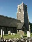 Church of St Andrew |
| Church of St Catherine | Mile Cross, Norwich | Church | 1933–1935 | 21 August 2006 | TG2195110923 52°39′02″N 1°16′47″E |
1391746 | 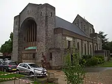 Church of St Catherine |
| Church of St John and All Saints | Lakenham, Norwich | Church | 15th century | 26 February 1954 | TG2335406088 52°36′24″N 1°17′50″E |
1372796 | .jpg.webp) Church of St John and All Saints |
| City Hall including Police Station | Norwich | Town Hall | 1932–38 | 29 January 1971 | TG2284408475 52°37′42″N 1°17′29″E |
1210484 |  City Hall including Police Station |
| Cotman House | Norwich | Apartment | 26 February 1954 | TG2341809076 52°38′00″N 1°18′01″E |
1051854 |  Cotman House | |
| Cringleford Bridge | Norwich | Road Bridge | 1520 | 19 October 1951 | TG1998305952 52°36′24″N 1°14′51″E |
1050565 | .jpg.webp) Cringleford Bridge |
| Dolphin Inn | Norwich | Bishops Palace/Health Centre | 1587(?) | 26 February 1954 | TG2195009766 52°38′25″N 1°16′44″E |
1372818 | 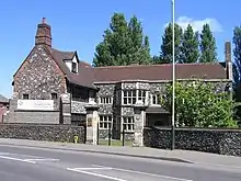 Dolphin Inn |
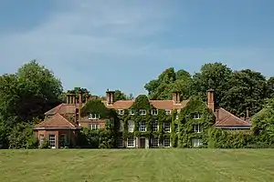
| Earlham Hall and attached Outbuildings | Earlham, Norwich | House | Late 16th century | 26 February 1954 | 49°46′01″N 7°33′26″W | 1051296 | |
| Friends Meeting House | Norwich | Chapel | 1826 | 26 February 1954 | TG2280208656 52°37′48″N 1°17′27″E |
1051780 | |
| General Post Office Museum | Norwich | Timber Framed House | 15th century | 21 September 1970 | TG2306208713 52°37′49″N 1°17′41″E |
1051892 | .jpg.webp) General Post Office Museum |
| Haydn House | Norwich | House | 18th century | 26 February 1954 | TG2367008868 52°37′53″N 1°18′13″E |
1280233 | |
| Holkham House | Norwich | Apartment | 26 February 1954 | TG2253108686 52°37′49″N 1°17′13″E |
1206535 | | |
| Howard's House | Norwich | House | 17th century | 26 February 1954 | TG2346808307 52°37′35″N 1°18′01″E |
1372824 | |
| Inverleith | Norwich | Courtyard House | 1908-9 | 11 February 2004 | TG2199407045 52°36′57″N 1°16′40″E |
1391059 | |
| Lazar House | Norwich | Library | 26 February 1954 | TG2356510413 52°38′43″N 1°18′12″E |
1051828 |  Lazar House | |
| Manor House | Norwich | House | 1578 | 26 February 1954 | TG2375207444 52°37′07″N 1°18′14″E |
1051379 | 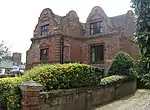 Manor House |
| Norfolk Terrace and attached Walkways at the University of East Anglia | University of East Anglia, Norwich | Hall of Residence | 1964–1968 | 16 October 2003 | TG1923407406 52°37′12″N 1°14′14″E |
1390647 | 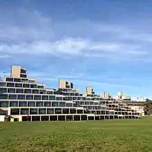 Norfolk Terrace and attached Walkways at the University of East Anglia |
| Nos. 39 & 41, St Andrew's Street (the Festival House) | Norwich | Public House | 19th century | 5 June 1972 | TG2311308756 52°37′50″N 1°17′44″E |
1372492 | |
| Nos. 31–35, Magdalen Street and Gurney Court | Norwich | House | 1986 | 26 February 1954 | TG2317809190 52°38′04″N 1°17′48″E |
1051188 | |
| Octagon Chapel | Norwich | Presbyterian Chapel | 1756 | 26 February 1954 | TG2308009071 52°38′01″N 1°17′43″E |
1280186 | 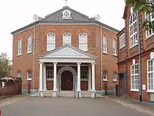 Octagon Chapel |
| Old Post Office Yard behind No. 19 Bedford Street to right of Carriage Arch | Norwich | House | 15th century | 15 October 1970 | TG2307308670 52°37′48″N 1°17′41″E |
1205180 | Old Post Office Yard behind No. 19 Bedford Street to right of Carriage Arch |
| Precinct Wall | Norwich | Cathedral Close | 13th century | 5 June 1972 | TG2343109027 52°37′59″N 1°18′01″E |
1051331 | |
| Printing Museum, Jarrold's Printing Works | Norwich | Warehouse | C20 | 8 April 1986 | TG2341309260 52°38′06″N 1°18′01″E |
1211208 | |
| Pykerell's House | Norwich | Hall House | 15th century | 26 February 1954 | TG2280509090 52°38′02″N 1°17′28″E |
1290996 | |
| Red Lion Public House | Eaton, Norwich | Inn | Late 17th century | 26 February 1954 | TG2018906119 52°36′30″N 1°15′02″E |
1372802 | 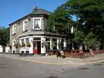 Red Lion Public House |
| Remains of Monastic Infirmary | Norwich | Monastery | 1175–1200 | 5 June 1972 | TG2351008812 52°37′52″N 1°18′05″E |
1051313 | .jpg.webp) Remains of Monastic Infirmary |
| Royal Arcade | Norwich | Shop | C20 | 5 June 1972 | TG2302708474 52°37′41″N 1°17′38″E |
1205148 | 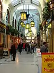 Royal Arcade |
| Sainsbury Centre, Attached Walkway, Underground Loading Bay, and Retaining Walls to Loading Bay Access Road at the University of | Norwich | Art Gallery | 1977 | 19 December 2012 | TG1906307438 52°37′14″N 1°14′05″E |
1409810 | 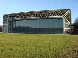 Sainsbury Centre, Attached Walkway, Underground Loading Bay, and Retaining Walls to Loading Bay Access Road at the University of |
| St Catherine's Close | Norwich | House | 1780 | 26 February 1954 | TG2307907956 52°37′25″N 1°17′40″E |
1051385 |  St Catherine's Close |
| St Helen's House | Norwich | House | 18th century | 5 June 1972 | TG2366309052 52°37′59″N 1°18′14″E |
1051366 | |
| Suffolk Terrace and adjoining Walkway and Stairs to Rear at the University of East Anglia | University of East Anglia, Norwich | Hall of Residence | 1964–1968 | 16 October 2003 | TG1943007413 52°37′12″N 1°14′25″E |
1390646 | 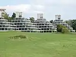 Suffolk Terrace and adjoining Walkway and Stairs to Rear at the University of East Anglia |
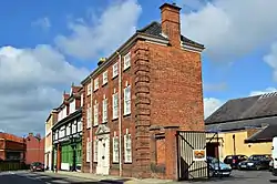
| Telephone House | Norwich | Office | 1906 | 5 June 1972 | TG2270308593 52°37′46″N 1°17′21″E |
1372484 | |
| The Briton's Arms | Norwich | Restaurant | 26 February 1954 | TG2319308827 52°37′53″N 1°17′48″E |
1372804 |  The Briton's Arms | |
| The Louis Marchesi Public House | Norwich | Public House/café | 26 February 1976 | TG2331008887 52°37′54″N 1°17′54″E |
1210774 | 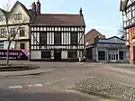 The Louis Marchesi Public House | |
| Tower and Adjoining Retaining Wall to Rear of No. 58, Bracondale | Norwich | Tower House | Pre 17th century | 26 February 1954 | TG2378407395 52°37′05″N 1°18′16″E |
1280541 | |
| Undercroft beneath No. 3, Queen Street | Norwich | Undercroft | Medieval | 5 June 1972 | TG2327408694 52°37′48″N 1°17′52″E |
1291066 | |
| War Memorial and War Memorial Garden Terrace | Norwich | War memorial | 1927 | 30 September 1983 | TG2291008511 52°37′42″N 1°17′33″E |
1051857 | |
| Pulls Ferry | Norwich | Water Gate | 15th century | 26 February 1954 | TG2389708758 52°37′49″N 1°18′25″E |
1206380 | 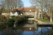 Pulls Ferry |
| 11–15 Fye Bridge Street | Norwich | House | 19th century | 26 February 1954 | TG2320509057 52°38′00″N 1°17′49″E |
1025094 | |
| No 1, The Close | Norwich | Office | 26 February 1954 | TG2339908751 52°37′50″N 1°17′59″E |
1051333 | | |
| No 2, The Close | Norwich | House | 1702 | 26 February 1954 | TG2340708736 52°37′49″N 1°17′59″E |
1206337 | .jpg.webp) No 2, The Close |
| Nos 3 & 4, The Close | Norwich | Barn | 17th century | 26 February 1954 | TG2343608716 52°37′49″N 1°18′01″E |
1051334 | .jpg.webp) Nos 3 & 4, The Close |
| No 5, The Close | Norwich | Barn | 17th century | 26 February 1954 | TG2344808721 52°37′49″N 1°18′01″E |
1206349 | |
| No 6, The Close | Norwich | House | 16th century | 26 February 1954 | TG2347308734 52°37′49″N 1°18′03″E |
1051335 | .jpg.webp) No 6, The Close |
| No 7, The Close | Norwich | House | Late 18th century | 26 February 1954 | TG2354108768 52°37′50″N 1°18′06″E |
1051336 | .jpg.webp) No 7, The Close |
| Nos 8 & 9, The Close | Norwich | House | Late 18th century | 26 February 1954 | TG2356208771 52°37′50″N 1°18′08″E |
1372760 | Nos 8 & 9, The Close |
| Nos 10–12, The Close | Norwich | House | 16th century | 26 February 1954 | TG2358608772 52°37′50″N 1°18′09″E |
1280248 | |
| No 14a, The Close | Norwich | House | 17th century | 5 June 1972 | TG2362508742 52°37′49″N 1°18′11″E |
1051337 | |
| No 16, The Close | Norwich | House | Pre 1850 | 26 February 1954 | TG2367008752 52°37′49″N 1°18′13″E |
1206365 | |
| No 17, The Close | Norwich | House | 1972 | 5 June 1972 | TG2365808770 52°37′50″N 1°18′13″E |
1372761 | |
| No 18, The Close | Norwich | House | Late 18th century | 5 June 1972 | TG2367008770 52°37′50″N 1°18′13″E |
1206370 | |
| No 25, The Close | Norwich | House | 1647 | 26 February 1954 | TG2389308748 52°37′49″N 1°18′25″E |
1372762 | |
| No 26, The Close | Norwich | House | Early 19th century | 26 February 1954 | TG2372508781 52°37′50″N 1°18′16″E |
1372763 | |
| No 27, The Close | Norwich | House | 26 February 1954 | TG2371408790 52°37′51″N 1°18′16″E |
1206385 | | |
| No 28, The Close | Norwich | House | 26 February 1954 | TG2370708790 52°37′51″N 1°18′15″E |
1051341 | | |
| No 29, The Close | Norwich | House | C16/C17 | 5 June 1972 | TG2368408785 52°37′51″N 1°18′14″E |
1206389 | |
| No 30, The Close | Norwich | House | 26 February 1954 | TG2366908793 52°37′51″N 1°18′13″E |
1051301 | | |
| No 31 The Close | Norwich | House | 26 February 1954 | TG2365308804 52°37′51″N 1°18′12″E |
1372782 | | |
| Nos 32 & 33, The Close | Norwich | House | 1682 | 26 February 1954 | TG2364008802 52°37′51″N 1°18′12″E |
1051302 | 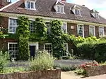 Nos 32 & 33, The Close |
| No 34, The Close | Norwich | Brewhouse | 18th century | 26 February 1954 | TG2364008824 52°37′52″N 1°18′12″E |
1372783 | |
| Nos 35a, 35b and 35c, The Close | Norwich | Apartment | By 1972 | 5 June 1972 | TG2367408854 52°37′53″N 1°18′14″E |
1051303 | |
| No 36, The Close | Norwich | House | 17th century | 5 June 1972 | TG2368008860 52°37′53″N 1°18′14″E |
1051304 | |
| Nos 37 and 38, The Close | Norwich | House | 1633 | 5 June 1972 | TG2369208863 52°37′53″N 1°18′15″E |
1372784 | |
| No 39, The Close | Norwich | House | 17th century | 5 June 1972 | TG2369908864 52°37′53″N 1°18′15″E |
1051305 | |
| No 40, The Close | Norwich | House | 17th century | 26 February 1954 | TG2370508877 52°37′53″N 1°18′15″E |
1372785 | |
| No 41, The Close | Norwich | House | Early 18th century | 5 June 1972 | 49°46′01″N 7°33′26″W | 1051306 | |
| Nos 43 & 44, The Close | Norwich | House | Late 17th century | 26 February 1954 | TG2366708981 52°37′57″N 1°18′14″E |
1051307 | |
| No 45, The Close | Norwich | Bakery | Early 19th century | 5 June 1972 | TG2368008889 52°37′54″N 1°18′14″E |
1206406 | |
| No 46, The Close | Norwich | House | Early 19th century | 26 February 1954 | TG2367908872 52°37′53″N 1°18′14″E |
1372786 | |
| No 49, The Close | Norwich | House | C14/C15 | 26 February 1954 | TG2366108863 52°37′53″N 1°18′13″E |
1051308 | |
| No 50, The Close | Norwich | House | 17th century | 26 February 1954 | TG2364808856 52°37′53″N 1°18′12″E |
1206417 | |
| Nos 51–55, The Close | Norwich | House | 15th century | 26 February 1954 | TG2360508847 52°37′53″N 1°18′10″E |
1051309 | |
| No 56, The Close | Norwich | House | 16th century | 26 February 1954 | TG2357708846 52°37′53″N 1°18′08″E |
1051310 | .jpg.webp) No 56, The Close |
| No 65, The Close | Norwich | House | 16th century | 5 June 1972 | TG2348508794 52°37′51″N 1°18′03″E |
1372787 | |
| Nos 67a, 67b, 67c and 68, The Close | Norwich | Clergy House | 15th century | 26 February 1954 | TG2344608801 52°37′51″N 1°18′01″E |
1206435 | |
| No 71, The Close | Norwich | House | Early 17th century | 5 June 1972 | TG2336608858 52°37′53″N 1°17′57″E |
1280207 | |
| No 73, The Close | Norwich | Office | Early 19th century | 5 June 1972 | TG2338708806 52°37′52″N 1°17′58″E |
1280208 | .jpg.webp) No 73, The Close |
| 71, Botolph Street | Norwich | Shop | C20 | 8 April 1986 | TG2293909461 52°38′13″N 1°17′36″E |
1051372 | |
| 13–17 St Giles Street | Norwich | Shop | 19th century | 5 June 1972 | TG2283408578 52°37′45″N 1°17′28″E |
1372482 | |
| 35, St Giles Street | Norwich | House | Late C16/Early 17th century | 26 February 1954 | TG2273908588 52°37′46″N 1°17′23″E |
1290649 | |
| 46, St Giles Street | Norwich | House | 19th century | 5 June 1972 | TG2267808576 52°37′45″N 1°17′20″E |
1051841 | |
| 48, St Giles Street | Norwich | House | 19th century | 26 February 1954 | TG2266408576 52°37′45″N 1°17′19″E |
1051842 | |
| 56–60, King Street | Norwich | Public House/Shops (Da Vinci hairdressers) | 19th century | 26 February 1954 | 49°46′01″N 7°33′26″W | 1051240 |  56–60, King Street |
| 91, King Street | Norwich | House | Late 15th century | 5 June 1972 | TG2345008336 52°37′36″N 1°18′01″E |
1051235 | |
| 125, 125a and 127, King Street | Norwich | Shop | C20 | 26 February 1954 | TG2357308161 52°37′31″N 1°18′07″E |
1217899 | |
| 168, King Street | Norwich | House | C20 | 26 February 1954 | TG2360908034 52°37′26″N 1°18′08″E |
1051205 | |
| 170 & 172, King Street | Norwich | House | 17th century | 26 February 1954 | TG2361808020 52°37′26″N 1°18′09″E |
1051206 | |
| 9, Surrey Street | Norwich | House | 1764 | 26 February 1954 | TG2299808129 52°37′30″N 1°17′36″E |
1051830 | |
| 11 & 13, Elm Hill | Norwich | House | Early 18th century | 8 April 1986 | TG2320608829 52°37′53″N 1°17′49″E |
1298580 | |
| 28 & 30, Elm Hill | Norwich | Shop | C20 | 26 February 1954 | TG2321508890 52°37′55″N 1°17′49″E |
1206720 | 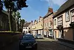 28 & 30, Elm Hill |
| 34 & 36, Elm Hill | Norwich | House (Flint and yellow rendering) | 26 February 1954 | TG2323108924 52°37′56″N 1°17′50″E |
1051270 | .jpg.webp) 34 & 36, Elm Hill | |
| 41 & 43, Elm Hill | Norwich | Courtyard House | Early 19th century | 26 February 1954 | TG2322908891 52°37′55″N 1°17′50″E |
1372805 |  41 & 43, Elm Hill |
| 18, Colegate | Norwich | House | Early 18th century | 26 February 1954 | TG2311909031 52°37′59″N 1°17′45″E |
1372773 | |
| 20, Colegate | Norwich | House | Early 17th century | 26 February 1954 | TG2310109022 52°37′59″N 1°17′44″E |
1051283 | |
| 65 Pottergate | Norwich | House | C17 | 5 June 1972 | TG2269008706 52°37′49″N 1°17′21″E |
1051938 | |
| 38 & 40 Bethel Street | Norwich | House | 18th century | 5 June 1972 | TG2272508480 52°37′42″N 1°17′22″E |
1051399 | |
| 42–48, Bethel Street | Norwich | Wall | C20 | 8 April 1986 | TG2270708489 52°37′42″N 1°17′21″E |
1372714 | |
| 2, Redwell Street | Norwich | Shop | 19th century | 8 April 1986 | TG2321208702 52°37′49″N 1°17′49″E |
1051881 | |
| 7, Princes Street | Norwich | Office | 26 February 1954 | TG2317908766 52°37′51″N 1°17′47″E |
1220186 | | |
| 9, Princes Street | Norwich | Office | 26 February 1954 | TG2318608768 52°37′51″N 1°17′48″E |
1051913 | | |
| 20, Princes Street | Norwich | Restaurant | C20 | 26 February 1954 | TG2327508829 52°37′53″N 1°17′52″E |
1051911 | 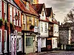 20, Princes Street |
| 5, Bedford Street | Norwich | Shop | 1972 | 5 June 1972 | TG2302608655 52°37′47″N 1°17′39″E |
1205170 | |
| 15, Bedford Street | Norwich | Shop | 16th century | 5 June 1972 | TG2305608654 52°37′47″N 1°17′40″E |
1051390 | |
| 52 & 54, Bishopgate | Norwich | House | 17th century | 5 June 1972 | TG2387708984 52°37′57″N 1°18′25″E |
1205621 | |
| 4, Tombland | Norwich | House | 18th century | 26 February 1954 | TG2331308784 52°37′51″N 1°17′54″E |
1290353 | |
| 5 & 5a, Tombland | Norwich | House | Mid 18th century | 26 February 1954 | TG2330908795 52°37′51″N 1°17′54″E |
1051808 |  5 & 5a, Tombland |
| 8, Tombland | Norwich | House/Tombland Bookshop | Pre 18th century | 5 June 1972 | TG2333208825 52°37′52″N 1°17′55″E |
1210760 | .jpg.webp) 8, Tombland |
| 1 and 3 Timberhill | Norwich | House | 17th century | 28 March 1972 | TG2310308329 52°37′37″N 1°17′42″E |
1372475 | |
| 2 Charing Cross | Norwich | Shop | C20 | 5 June 1972 | TG2293008744 52°37′50″N 1°17′34″E |
1372734 | |
| 22 and 24 Lower Goat Lane | Norwich | Wall | C20 | 5 June 1972 | TG2285508654 52°37′47″N 1°17′30″E |
1218739 | |
| 7 St Faith's Lane | Norwich | House | 17th century | 5 June 1972 | TG2369108621 52°37′45″N 1°18′14″E |
1220856 | |
| 3 and 4 Haymarket | Norwich | House | 18th century | 26 February 1954 | TG2299308414 52°37′40″N 1°17′36″E |
1209850 | |
| 6, 9 and 10 Ninham's Court | Norwich | House | 16th century | 5 June 1972 | TG2259108522 52°37′44″N 1°17′15″E |
1051924 | |
| 2–9 Octagon Court | Norwich | Flats | C18 | 26 February 1954 | TG2305509047 52°38′00″N 1°17′41″E |
1051929 | |
| 19–21, Bedford Street | Norwich | Shop | C20 | 15 October 1970 | TG2307708661 52°37′47″N 1°17′41″E |
1372711 | |
| 27–30, Gentleman's Walk | Norwich | House | 17th century | 26 May 1954 | TG2299608452 52°37′41″N 1°17′37″E |
1051245 | .jpg.webp) 27–30, Gentleman's Walk |
| 24, Gentleman's Walk | Norwich | House | Mid 19th century | 5 June 1972 | TG2299308479 52°37′42″N 1°17′37″E |
1051244 | |
.jpg.webp)
Notes
- The date given is the date used by Historic England as significant for the initial building or that of an important part in the structure's description.
- Sometimes known as OSGB36, the grid reference is based on the British national grid reference system used by the Ordnance Survey.
- The "List Entry Number" is a unique number assigned to each listed building and scheduled monument by Historic England.
External links
![]() Media related to Grade II* listed buildings in Norfolk, England at Wikimedia Commons
Media related to Grade II* listed buildings in Norfolk, England at Wikimedia Commons
This article is issued from Wikipedia. The text is licensed under Creative Commons - Attribution - Sharealike. Additional terms may apply for the media files.