Grade II* listed buildings in South Kesteven
There are over 20,000 Grade II* listed buildings in England. This page is a list of these buildings in the district of South Kesteven in Lincolnshire.
South Kesteven
| Name | Location | Type | Completed [note 1] | Date designated | Grid ref.[note 2] Geo-coordinates |
Entry number [note 3] | Image |
|---|---|---|---|---|---|---|---|
| Church of the Holy Trinity | Allington, South Kesteven | Parish Church | c. 1150 | 20 September 1966 | SK8552840262 52°57′11″N 0°43′42″W |
1062909 | 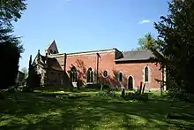 Church of the Holy Trinity |
| Old Manor House | Allington, South Kesteven | Country House | 17th century | 19 February 1952 | SK8559740142 52°57′07″N 0°43′39″W |
1360036 | 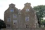 Old Manor House |
| Ancaster Hall | Ancaster, South Kesteven | Flats | 17th century | 19 September 1952 | SK9829543599 52°58′51″N 0°32′15″W |
1062421 | 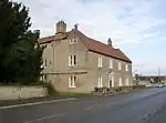 Ancaster Hall |
| Ancaster House | Ancaster, South Kesteven | House | 17th century | 19 February 1952 | SK9825343360 52°58′43″N 0°32′17″W |
1360298 |  |
| Sudbrook Old Hall | Sudbrook, Ancaster, South Kesteven | Farmhouse | 16th century | 19 February 1952 | SK9705944371 52°59′16″N 0°33′20″W |
1062424 | |
| Gateway to Aslackby Manor | Aslackby and Laughton, South Kesteven | Gate | Mid 17th century | 22 January 1987 | TF0841530388 52°51′36″N 0°23′28″W |
1360115 | |
| Barholm Old Hall | Barholm and Stowe, South Kesteven | House | 15th century | 6 May 1952 | TF0884210689 52°40′59″N 0°23′29″W |
1062697 | |
| Pigeoncote to Barholm Old Hall | Barholm and Stowe, South Kesteven | Dovecote | c. 1600 | 30 October 1968 | TF0886210706 52°40′59″N 0°23′28″W |
1360164 | |
| Bellmount Tower | Belton Park, Belton and Manthorpe, South Kesteven | Prospect Tower | Mid 18th century | 21 September 1979 | SK9489838814 52°56′18″N 0°35′22″W |
1194859 | 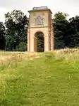 Bellmount Tower |
| Cascade at South West End of Boathouse Pond 600 Metres East of Belton House | Belton Park, Belton and Manthorpe, South Kesteven | Cascade | Early 18th century | 14 November 1994 | SK9351839264 52°56′33″N 0°36′35″W |
1194862 | 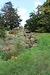 Cascade at South West End of Boathouse Pond 600 Metres East of Belton House |
| Entrance Gates and Railings to the Wilderness 150 Metres West of Belton House | Belton Park, Belton and Manthorpe, South Kesteven | Gate | Early 18th century | 21 September 1979 | SK9281639346 52°56′37″N 0°37′13″W |
1194863 | |
| Former Brewhouse to Belton House | Belton Park, Belton and Manthorpe, South Kesteven | Brewhouse | 1820 | 21 September 1979 | SK9286239360 52°56′37″N 0°37′10″W |
1235604 | |
| Garden Temple 200 Metres East of Belton House | Belton Park, Belton and Manthorpe, South Kesteven | Garden Temple | Early 18th century | 21 September 1979 | SK9318739367 52°56′37″N 0°36′53″W |
1264931 | 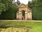 Garden Temple 200 Metres East of Belton House |
| Orangery at North End of Italian Garden 200 Metres North of Belton House | Belton Park, Belton and Manthorpe, South Kesteven | Orangery | 1821 | 19 February 1952 | SK9293439512 52°56′42″N 0°37′06″W |
1187972 | 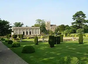 Orangery at North End of Italian Garden 200 Metres North of Belton House |
| Screen and Gateway to West Courtyard at Belton House | Belton Park, Belton and Manthorpe, South Kesteven | Gate | Early 18th century | 19 February 1952 | SK9293539297 52°56′35″N 0°37′06″W |
1194858 | 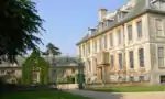 Screen and Gateway to West Courtyard at Belton House |
| Sundial 150 Metres North of Belton House | Belton Park, Belton and Manthorpe, South Kesteven | Sundial | c. 1690 | 21 September 1979 | SK9301239423 52°56′39″N 0°37′02″W |
1235882 | 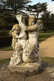 Sundial 150 Metres North of Belton House |
| West Wing to Belton House and Attached Boundary Wall | Belton Park, Belton and Manthorpe, South Kesteven | Boundary Wall | 1685-1688 | 19 February 1952 | SK9292839310 52°56′35″N 0°37′07″W |
1194857 | 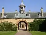 West Wing to Belton House and Attached Boundary Wall |
| The Old Hall | Billingborough, South Kesteven | Country House | Late 16th century | 6 May 1952 | TF1173434291 52°53′40″N 0°20′26″W |
1164828 | |
| Red Hall | Bourne, South Kesteven | House | Early 17th century | 2 May 1949 | TF0960619816 52°45′53″N 0°22′37″W |
1259132 | 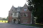 Red Hall |
| Church of St. Faith | Wilsthorpe, Braceborough and Wilsthorpe, South Kesteven | Parish Church | 1715 | 30 October 1968 | TF0922513647 52°42′34″N 0°23′05″W |
1062675 | 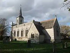 Church of St. Faith |
| Church of St Margaret | Braceby, Braceby and Sapperton, South Kesteven | Parish Church | 13th century | 20 September 1966 | TF0164135352 52°54′22″N 0°29′25″W |
1360324 | 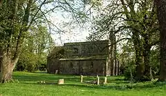 Church of St Margaret |
| Church of St Wilfrid in Grounds of Holywell Hall | Holywell, Careby Aunby and Holywell, South Kesteven | Church | 12th century | 30 October 1968 | TF0002816015 52°43′57″N 0°31′12″W |
1360080 | 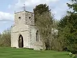 Church of St Wilfrid in Grounds of Holywell Hall |
| Fishing Temple in Grounds of Holywell Hall | Holywell, Careby Aunby and Holywell, South Kesteven | Garden Temple | c. 1732 | 30 October 1968 | SK9991915931 52°43′54″N 0°31′18″W |
1062834 | .jpg.webp) Fishing Temple in Grounds of Holywell Hall |
| Holywell Hall | Holywell, Careby Aunby and Holywell, South Kesteven | Country House | 17th century | 6 May 1952 | SK9999516046 52°43′58″N 0°31′14″W |
1062833 | |
| Pigeoncote at Holywell Hall | Holywell, Careby Aunby and Holywell, South Kesteven | Dovecote | Mid 17th century | 30 October 1968 | SK9996716077 52°43′59″N 0°31′15″W |
1062835 | .jpg.webp) Pigeoncote at Holywell Hall |
| The Priory | Castle Bytham, South Kesteven | House | 15th century | 30 October 1968 | SK9888118325 52°45′13″N 0°32′11″W |
1062846 | |
| Caythorpe Court | Caythorpe, South Kesteven | Country House | 1899 | 14 September 1984 | SK9575648281 53°01′24″N 0°34′26″W |
1062429 | |
| Caythorpe Hall | Caythorpe, South Kesteven | Country House | 1823 | 19 February 1955 | SK9384848882 53°01′44″N 0°36′08″W |
1165323 | .jpg.webp) Caythorpe Hall |
| Pickworth House | Caythorpe, South Kesteven | House | 1684 | 19 February 1952 | SK9381248244 53°01′24″N 0°36′10″W |
1062396 | 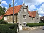 Pickworth House |
| Chapel Cottage | Colsterworth, South Kesteven | House | 12th century | 20 September 1966 | SK9228924409 52°48′34″N 0°37′56″W |
1365619 | |
| Deeping Gate Bridge over the River Welland | Deeping St James, South Kesteven | Bridge | 1651 | 24 February 1982 | TF1507209500 52°40′16″N 0°17′59″W |
1309230 |  Deeping Gate Bridge over the River Welland |
| Priory Farmhouse | Deeping St James, South Kesteven | House | Early 17th century | 30 October 1968 | TF1575709625 52°40′19″N 0°17′22″W |
1164963 | |
| Agent's House | Denton, South Kesteven | House | Early 17th century | 9 February 1952 | SK8700232284 52°52′52″N 0°42′31″W |
1360340 | 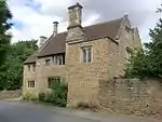 Agent's House |
| Garden Gateway to Agents House | Denton, South Kesteven | Gate | Mid 17th century | 21 September 1979 | SK8699332271 52°52′51″N 0°42′31″W |
1062341 | |
| St Christopher's Well in Denton Park | Denton, South Kesteven | Grotto | 1823 | 21 September 1979 | SK8618832030 52°52′44″N 0°43′15″W |
1062336 | |
| Church of St. Andrew | Dowsby, South Kesteven | Church | 11th century | 22 January 1987 | TF1132829276 52°50′58″N 0°20′54″W |
1164977 | 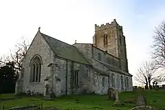 Church of St. Andrew |
| Dowsby Hall | Dowsby, South Kesteven | Country House | Early 17th century | 6 May 1952 | TF1105229307 52°50′59″N 0°21′09″W |
1317485 | |
| 3 Statues East of Grimsthorpe Castle | Grimsthorpe Park, Edenham, South Kesteven | Statue | Mid 18th century | 15 December 1986 | TF0452422837 52°47′35″N 0°27′05″W |
1360074 | 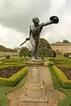 3 Statues East of Grimsthorpe Castle |
| 4 Garden Ornaments on South Terrace at Grimsthorpe Castle | Grimsthorpe Park, Edenham, South Kesteven | Formal Garden | c. 1723 | 15 December 1986 | TF0448422682 52°47′30″N 0°27′07″W |
1308944 | |
| Gardeners Cottage | Grimsthorpe Park, Edenham, South Kesteven | Estate Cottage | c. 1723 | 15 December 1986 | TF0472422472 52°47′23″N 0°26′55″W |
1166363 | |
| Folkingham Manor House | Folkingham, South Kesteven | Country House | c. 1650 | 30 October 1968 | TF0729033559 52°53′20″N 0°24′25″W |
1360148 | 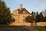 Folkingham Manor House |
| Greyhound Antique Shop | Folkingham, South Kesteven | Assembly Rooms | c. 1650 | 6 May 1952 | TF0719233696 52°53′24″N 0°24′30″W |
1062747 | 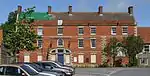 Greyhound Antique Shop |
| House of Correction | Folkingham, South Kesteven | House | 1825 | 6 May 1952 | TF0746033476 52°53′17″N 0°24′16″W |
1360144 | 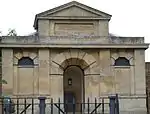 House of Correction |
| Ermine House | Fulbeck, South Kesteven | Country House | 17th century | 19 February 1952 | SK9469750296 53°02′30″N 0°35′21″W |
1062408 | |
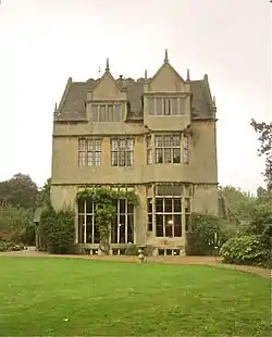
| Fulbeck Hall | Fulbeck, South Kesteven | Country House | 1733 | 19 February 1952 | SK9473350518 53°02′37″N 0°35′18″W |
1270291 | 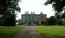 Fulbeck Hall |
| Fulbeck House | Fulbeck, South Kesteven | Country House | c. 1700 | 19 February 1952 | SK9488850674 53°02′42″N 0°35′10″W |
1309048 | |
| Fulbeck Manor | Fulbeck, South Kesteven | Country House | 17th century | 19 February 1952 | SK9478450249 53°02′28″N 0°35′16″W |
1166259 | .jpg.webp) Fulbeck Manor |
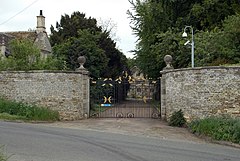
| Gates of Fulbeck Hall | Fulbeck, South Kesteven | Gate | 1733 | 14 September 1984 | SK9488450501 53°02′36″N 0°35′10″W |
1360292 |  Gates of Fulbeck Hall |
| Barn at Church Farm | Great Ponton, South Kesteven | Barn | 16th century | 9 January 1987 | SK9262330460 52°51′49″N 0°37′32″W |
1062348 | |
| The Old Rectory Wall and Gate Piers | Great Ponton, South Kesteven | House | 14th century | 19 February 1952 | SK9246130422 52°51′48″N 0°37′41″W |
1147917 | .jpg.webp) The Old Rectory Wall and Gate Piers |
| Barn at Greatford Hall | Greatford, South Kesteven | Barn | C20 | 30 October 1968 | TF0859911889 52°41′38″N 0°23′40″W |
1062684 | .jpg.webp) Barn at Greatford Hall |
| Heggy's Cottage | Haconby, South Kesteven | House | Late 16th century | 22 January 1987 | TF1037425219 52°48′48″N 0°21′50″W |
1062712 |  Heggy's Cottage |
| Baroque Terrace Fountain and Statues 25 Metres South East of Harlaxton Manor | Harlaxton, South Kesteven | Balustrade | 1838-1844 | 14 November 1994 | SK8957832246 52°52′49″N 0°40′13″W |
1236526 | 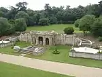 Baroque Terrace Fountain and Statues 25 Metres South East of Harlaxton Manor |
| Bridge 800 Metres North West of Harlaxton Manor | Harlaxton, South Kesteven | Bridge | 1822-1838 | 24 September 1979 | SK8877232864 52°53′09″N 0°40′56″W |
1187968 | 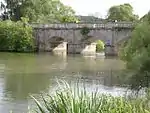 Bridge 800 Metres North West of Harlaxton Manor |
| Gatehouse 400 Metres North West of Harlaxton Manor and Attached Boundary Walls | Harlaxton, South Kesteven | Wall | c1832-1838 | 24 September 1979 | SK8917632550 52°52′59″N 0°40′34″W |
1236606 | 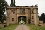 Gatehouse 400 Metres North West of Harlaxton Manor and Attached Boundary Walls |
| Gateway and Screen Wall 1200 Metres North West of Harlaxton Manor | Harlaxton, South Kesteven | Gate | c1832-1844 | 24 September 1979 | SK8847033089 52°53′17″N 0°41′12″W |
1298442 | 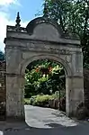 Gateway and Screen Wall 1200 Metres North West of Harlaxton Manor |
| Gazebo 80 Metres South of Harlaxton Manor | Harlaxton, South Kesteven | Gazebo | c1838-1844 | 14 November 1994 | SK8950432165 52°52′46″N 0°40′17″W |
1298388 | 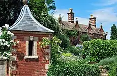 Gazebo 80 Metres South of Harlaxton Manor |
| Kitchen Garden Walls and Gardeners House 500 Metres North West of Harlaxton Manor | Harlaxton, South Kesteven | House | c1832-1844 | 24 September 1979 | SK8902832746 52°53′05″N 0°40′42″W |
1298389 | .jpg.webp) Kitchen Garden Walls and Gardeners House 500 Metres North West of Harlaxton Manor |
| Ornamental Garden Steps 50 Metres South West of Harlaxton Manor | Harlaxton, South Kesteven | Steps | c1838-1844 | 14 November 1994 | SK8947232212 52°52′48″N 0°40′19″W |
1236717 | |
| Heydour Priory | Heydour, South Kesteven | House | Late 16th century | 19 February 1952 | TF0102239465 52°56′35″N 0°29′53″W |
1308929 | |
| Oasby Manor House | Oasby, Heydour, South Kesteven | House | 17th century | 19 February 1952 | TF0027039056 52°56′22″N 0°30′34″W |
1062391 | |
| Well | Horbling, South Kesteven | Trough | 1711 | 22 January 1987 | TF1181535291 52°54′12″N 0°20′20″W |
1309087 | 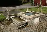 Well |
| Hougham Manor House | Hougham, South Kesteven | House | Medieval | 19 February 1952 | SK8882044187 52°59′16″N 0°40′42″W |
1062890 | .jpg.webp) Hougham Manor House |
| Brandon Old Hall | Brandon, Hough-on-the-Hill, South Kesteven | House | Early 16th century | 19 February 1952 | SK9041248338 53°01′29″N 0°39′12″W |
1166332 | 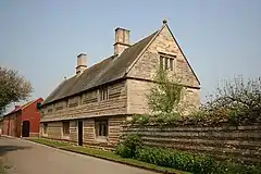 Brandon Old Hall |
| Chapel | Hough-on-the-Hill, South Kesteven | Chapel of Ease | Early 12th century | 20 September 1966 | SK9034448133 53°01′22″N 0°39′16″W |
1062416 | 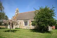 Chapel |
| Church of All Saints | Stroxton, Little Ponton and Stroxton, South Kesteven | Parish Church | 12th century | 20 September 1966 | SK9023531068 52°52′10″N 0°39′39″W |
1360365 | 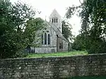 Church of All Saints |
| Pigeoncote at Little Ponton Hall | Little Ponton and Stroxton, South Kesteven | Dovecote | Early 18th century | 9 January 1987 | SK9281032218 52°52′46″N 0°37′20″W |
1360364 | |
| Archway at Harrowby Hall | Harrowby Without, Londonthorpe and Harrowby Without, South Kesteven | Arch | Early 17th century | 20 September 1984 | SK9361735834 52°54′42″N 0°36′34″W |
1253210 | |
| Church of St John the Baptist | Londonthorpe, Londonthorpe and Harrowby Without, South Kesteven | Parish Church | 13th century | 20 September 1966 | SK9532938031 52°55′52″N 0°35′00″W |
1253207 | 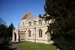 Church of St John the Baptist |
| Hall Farm House | Londonthorpe, Londonthorpe and Harrowby Without, South Kesteven | Farmhouse | c. 1730 | 20 September 1984 | SK9533338108 52°55′55″N 0°34′59″W |
1261914 | |
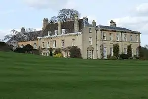
| Harrowby Hall | Harrowby Without, Londonthorpe and Harrowby Without, South Kesteven | Country House | 1628 | 20 September 1984 | SK9360935793 52°54′41″N 0°36′34″W |
1261915 |  Harrowby Hall |
| The Mill | Londonthorpe, Londonthorpe and Harrowby Without, South Kesteven | House | Late 18th century | 20 September 1984 | SK9242438090 52°55′56″N 0°37′35″W |
1253212 | |
| Marston Hall | Marston, South Kesteven | Country House | Late 16th century | 19 February 1952 | SK8935643664 52°58′58″N 0°40′14″W |
1062854 | |
| Parish Church of St Nicholas | Normanton, South Kesteven | Parish Church | 11th century | 20 September 1966 | SK9489346249 53°00′19″N 0°35′14″W |
1146921 | 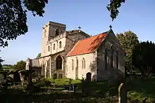 Parish Church of St Nicholas |
| Church of St Mary Magdalene | Old Somerby, South Kesteven | Parish Church | 12th century | 20 September 1966 | SK9648333962 52°53′40″N 0°34′02″W |
1261872 |  Church of St Mary Magdalene |
| Great Humby Chapel | Humby, Ropsley and Humby, South Kesteven | Chapel of Ease | built originally c1680 | 20 September 1966 | TF0071032338 52°52′45″N 0°30′18″W |
1253290 | 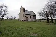 Great Humby Chapel |
| Sedgebrook Manor House | Sedgebrook, South Kesteven | Manor House | c. 1632 | 19 February 1952 | SK8573238123 52°56′01″N 0°43′33″W |
1298359 | |
| Assembly Rooms | Stamford, South Kesteven | Assembly Rooms | 1727 | 22 May 1954 | TF0314207060 52°39′05″N 0°28′36″W |
1168799 | |
| Barn Hill House | Stamford, South Kesteven | House | Late 17th century | 22 May 1954 | TF0275707203 52°39′10″N 0°28′57″W |
1360348 | .jpg.webp) Barn Hill House |
| Brazenose School House (part of Stamford School) | Stamford, South Kesteven | School House | Early 18th century | 22 May 1954 | TF0331807324 52°39′14″N 0°28′27″W |
1062946 | 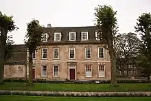 Brazenose School House (part of Stamford School) |
| Bull and Swan Inn | Stamford, South Kesteven | House | Late 16th century | 22 May 1954 | TF0315306684 52°38′53″N 0°28′36″W |
1062163 | .jpg.webp) Bull and Swan Inn |
| Burghley Almshouses Lord Burghley's Hospital | Stamford, South Kesteven | Garden Wall | 1597 | 22 May 1954 | TF0302406903 52°39′00″N 0°28′43″W |
1360415 | .jpg.webp) Burghley Almshouses Lord Burghley's Hospital |
| Bursar's House | Stamford, South Kesteven | House | Modern | 26 April 1974 | TF0325707325 52°39′14″N 0°28′30″W |
1062944 | .jpg.webp) Bursar's House |
| Clapton House | Stamford, South Kesteven | House | Mid 18th century | 22 May 1954 | TF0328807310 52°39′13″N 0°28′28″W |
1169988 | |
| Gazebo in Garden of Barn Hill House | Stamford, South Kesteven | Gazebo | Mid 18th century | 22 May 1954 | TF0276007231 52°39′11″N 0°28′57″W |
1062279 | |
| Municipal Offices | Stamford, South Kesteven | Arch | 18th century | 22 May 1954 | TF0306406982 52°39′03″N 0°28′41″W |
1062179 | .jpg.webp) Municipal Offices |
| Number 4 (Browne's Hospital) Chapel and Hall. All Other Buildings at Browne's Hospital | Stamford, South Kesteven | Church Hall | 15th century | 22 May 1954 | TF0295707286 52°39′13″N 0°28′46″W |
1062247 | 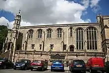 Number 4 (Browne's Hospital) Chapel and Hall. All Other Buildings at Browne's Hospital |
| Old Theatre | Stamford, South Kesteven | Club | 1766 | 22 May 1954 | TF0311907077 52°39′06″N 0°28′38″W |
1062976 | .jpg.webp) Old Theatre |
| Railings and Terrace to No 1 Broad Street | Stamford, South Kesteven | Gate | 26 April 1974 | TF0292407195 52°39′10″N 0°28′48″W |
1062288 | | |
| St Martin's Guest House | Stamford, South Kesteven | House | Late 18th century | 22 May 1954 | TF0307706556 52°38′49″N 0°28′40″W |
1169212 | |
| Stamford Hotel | Stamford, South Kesteven | Hotel | 1820 | 22 May 1954 | TF0304907082 52°39′06″N 0°28′41″W |
1062971 | .jpg.webp) Stamford Hotel |
| Stukeley House (9 Barn Hill) | Stamford, South Kesteven | House | 1741 | 22 May 1954 | TF0277307259 52°39′12″N 0°28′56″W |
1147402 | |
| Sunday School, Barn Hill | Stamford, South Kesteven | Sunday School | 18th century | 22 May 1954 | TF0280007270 52°39′12″N 0°28′54″W |
1308533 | |
| The George Hotel | Stamford, South Kesteven | Hall House | 14th century | 22 May 1954 | TF0305106846 52°38′58″N 0°28′41″W |
1169387 | |
| Town Hall | Stamford, South Kesteven | Town Hall | 1777 | 22 May 1954 | TF0305407017 52°39′04″N 0°28′41″W |
1306544 | .jpg.webp) Town Hall |
| Wall and Gatepiers to Barn Hill House | Stamford, South Kesteven | Gate Pier | 18th century | 26 April 1974 | TF0277507219 52°39′11″N 0°28′56″W |
1147390 | Wall and Gatepiers to Barn Hill House |
| Wall and Gates to No 2 Broad Street | Stamford, South Kesteven | Gate | 26 April 1974 | TF0294107217 52°39′11″N 0°28′47″W |
1062289 | | |
| Welland House (junior House of Girls' High School) | Stamford, South Kesteven | House | 1795 | 22 May 1954 | TF0320506871 52°38′59″N 0°28′33″W |
1062936 | |
| 21 St George's Square | Stamford, South Kesteven | House | 1772 | 22 May 1954 | TF0315407057 52°39′05″N 0°28′36″W |
1062223 | |
| 10 Barn Hill | Stamford, South Kesteven | House | 17th century | 22 May 1954 | TF0277607251 52°39′12″N 0°28′56″W |
1062280 | |
| 1 Broad Street | Stamford, South Kesteven | House | 17th century | 22 May 1954 | TF0290707205 52°39′10″N 0°28′49″W |
1062287 | 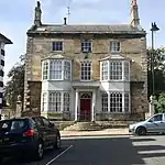 1 Broad Street |
| 11 and 12 High Street | Stamford, South Kesteven | Shop | Modern | 22 May 1954 | TF0298607159 52°39′09″N 0°28′45″W |
1062227 | .jpg.webp) 11 and 12 High Street |
| 18 St George's Square | Stamford, South Kesteven | House | Early 18th century | 22 May 1954 | TF0318807054 52°39′05″N 0°28′34″W |
1062221 | |
| 43 St Martin's | Stamford, South Kesteven | House | 18th century | 22 May 1954 | TF0316406596 52°38′50″N 0°28′36″W |
1062170 | 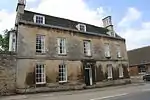 43 St Martin's |
| 1 All Saints' Place | Stamford, South Kesteven | House | Late 18th century | 22 May 1954 | TF0285007200 52°39′10″N 0°28′52″W |
1062302 | 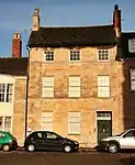 1 All Saints' Place |
| 2 St Mary's Place | Stamford, South Kesteven | House | Early 18th century | 22 May 1954 | TF0308807042 52°39′05″N 0°28′39″W |
1062962 | |
| 20 St George's Square | Stamford, South Kesteven | House | Late 18th century | 22 May 1954 | TF0316507058 52°39′05″N 0°28′35″W |
1062222 | |
| 34 Broad Street | Stamford, South Kesteven | House | Mid 18th century | 22 May 1954 | TF0305407259 52°39′12″N 0°28′41″W |
1062257 | |
| 8–10 St Martin's | Stamford, South Kesteven | Shop | Mid 19th century | 22 May 1954 | TF0307406858 52°38′59″N 0°28′40″W |
1062198 | |
| 12 Barn Hill | Stamford, South Kesteven | House | Late 17th century | 22 May 1954 | TF0278907234 52°39′11″N 0°28′55″W |
1062281 | |
| 6 Red Lion Square | Stamford, South Kesteven | Jettied House | 15th century | 26 April 1974 | TF0289807096 52°39′07″N 0°28′49″W |
1062212 | |
| 15–17 High Street | Stamford, South Kesteven | Building | Early 18th century | 22 May 1954 | TF0300207171 52°39′09″N 0°28′44″W |
1062229 | |
| 6 Barn Hill | Stamford, South Kesteven | House | 17th century | 22 May 1954 | TF0278207200 52°39′10″N 0°28′55″W |
1062278 | 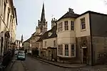 6 Barn Hill |
| 2 All Saints' Place | Stamford, South Kesteven | House | Mid 18th century | 22 May 1954 | TF0285607196 52°39′10″N 0°28′51″W |
1062303 | |
| 15 Barn Hill | Stamford, South Kesteven | House | Early 19th century | 22 May 1954 | TF0282607213 52°39′10″N 0°28′53″W |
1062282 | |
| 24 St Martin's | Stamford, South Kesteven | House | Early 19th century | 22 May 1954 | TF0314406713 52°38′54″N 0°28′37″W |
1062161 | |
| 46 St Martin's | Stamford, South Kesteven | House | Late 18th century | 22 May 1954 | TF0312706655 52°38′52″N 0°28′38″W |
1062172 | |
| 14 High Street | Stamford, South Kesteven | Shop | Modern | 22 May 1954 | TF0300107162 52°39′09″N 0°28′44″W |
1062228 | |
| 1 and 2 Burghley Lane | Stamford, South Kesteven | House | Early 17th century | 22 May 1954 | TF0321006586 52°38′50″N 0°28′33″W |
1062260 | |
| 24a St Martin's | Stamford, South Kesteven | House | Early 19th century | 22 May 1954 | TF0315006696 52°38′54″N 0°28′36″W |
1062162 | |
| 52 St Martin's | Stamford, South Kesteven | House | 17th century | 22 May 1954 | TF0311606688 52°38′53″N 0°28′38″W |
1062173 | |
| 20 High Street | Stamford, South Kesteven | Shop | 19th century | 22 May 1954 | TF0303207185 52°39′09″N 0°28′42″W |
1062230 | |
| 13 St Mary's Street | Stamford, South Kesteven | Lamp Bracket | First half of 19th century | 22 May 1954 | TF0300307072 52°39′06″N 0°28′44″W |
1062969 | |
| 34 St Martin's | Stamford, South Kesteven | House | Mid 18th century | 22 May 1954 | TF0319806594 52°38′50″N 0°28′34″W |
1062167 | |
| 36 St Martin's | Stamford, South Kesteven | House | Mid-late 18th century | 22 May 1954 | TF0320806561 52°38′49″N 0°28′33″W |
1062168 | |
| 71 High Street | Stamford, South Kesteven | Shop | Early 19th century | 26 April 1974 | TF0293907102 52°39′07″N 0°28′47″W |
1062239 | |
| 23 St Mary's Street | Stamford, South Kesteven | House | c. 1750 | 22 May 1954 | TF0312407106 52°39′07″N 0°28′37″W |
1062974 | .jpg.webp) 23 St Mary's Street |
| 4 and 5 All Saints Place | Stamford, South Kesteven | House | Late 17th century or early 18th century | 22 May 1954 | TF0286807181 52°39′09″N 0°28′51″W |
1062304 | |
| 3 Barn Hill | Stamford, South Kesteven | House | Mid 18th century | 22 May 1954 | TF0281507190 52°39′10″N 0°28′54″W |
1062277 | 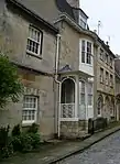 3 Barn Hill |
| 7 Ironmonger Street | Stamford, South Kesteven | Building | 1801 | 22 May 1954 | TF0302807190 52°39′10″N 0°28′42″W |
1062243 | |
| 11 and 12 St Mary's Street | Stamford, South Kesteven | Shop | 19th century | 22 May 1954 | TF0299607074 52°39′06″N 0°28′44″W |
1062968 | |
| 3 St Mary's Place | Stamford, South Kesteven | House | Mid 18th century | 22 May 1954 | TF0307807041 52°39′05″N 0°28′40″W |
1062963 | |
| 15 and 15a St Mary's Street | Stamford, South Kesteven | Boot Scraper | Modern | 22 May 1954 | TF0303007077 52°39′06″N 0°28′42″W |
1062970 | |
| 20 St Mary's Street | Stamford, South Kesteven | House | 18th century | 22 May 1954 | TF0309307105 52°39′07″N 0°28′39″W |
1062973 | |
| 27 St Mary's Street | Stamford, South Kesteven | House | Early 19th century | 22 May 1954 | TF0313307078 52°39′06″N 0°28′37″W |
1062975 | .jpg.webp) 27 St Mary's Street |
| 17 Barn Hill | Stamford, South Kesteven | House | 18th century | 22 May 1954 | TF0284307203 52°39′10″N 0°28′52″W |
1147459 | |
| 5 Barn Hill | Stamford, South Kesteven | House | 17th century | 22 May 1954 | TF0279207197 52°39′10″N 0°28′55″W |
1147366 | |
| 19 St George's Square | Stamford, South Kesteven | House | 1674 | 22 May 1954 | TF0317607056 52°39′05″N 0°28′35″W |
1168787 | .jpg.webp) 19 St George's Square |
| 68 and 69 St Martin's | Stamford, South Kesteven | House | Late 17th century or early 18th century | 22 May 1954 | TF0304606827 52°38′58″N 0°28′42″W |
1169363 | |
| 53 St Martin's | Stamford, South Kesteven | House | 17th century | 22 May 1954 | TF0311006708 52°38′54″N 0°28′39″W |
1169304 | |
| 25 and 26 St Mary's Street | Stamford, South Kesteven | Garage | Early 19th century | 22 May 1954 | TF0315407101 52°39′07″N 0°28′36″W |
1169809 | .jpg.webp) 25 and 26 St Mary's Street |
| 45 St Martin's | Stamford, South Kesteven | House | Early-mid 18th century | 22 May 1954 | TF0313706644 52°38′52″N 0°28′37″W |
1169247 | |
| 22 St Mary's Street | Stamford, South Kesteven | House | c. 1770 | 22 May 1954 | TF0311007105 52°39′07″N 0°28′38″W |
1169808 | |
| 62 St Leonard's Street | Stamford, South Kesteven | House | 17th century | 22 May 1954 | TF0321607166 52°39′09″N 0°28′32″W |
1306706 | |
| 4 St Mary's Street | Stamford, South Kesteven | Shop | Early 19th century | 22 May 1954 | TF0294607054 52°39′05″N 0°28′47″W |
1306445 | |
| 20 and 21 Broad Street | Stamford, South Kesteven | House | Late 18th century | 22 May 1954 | TF0315907323 52°39′14″N 0°28′35″W |
1308463 | |
| 14 St Mary's Street | Stamford, South Kesteven | Shop | First half of 19th century | 22 May 1954 | TF0301607076 52°39′06″N 0°28′43″W |
1306425 | |
| 9 and 10 Ironmonger Street | Stamford, South Kesteven | Boot Scraper | Early 19th century | 22 May 1954 | TF0302407196 52°39′10″N 0°28′43″W |
1307000 | |
| 24 St Mary's Street | Stamford, South Kesteven | House | Mid 18th century | 22 May 1954 | TF0313207108 52°39′07″N 0°28′37″W |
1360030 | |
| 4 Barn Hill | Stamford, South Kesteven | House | 17th century | 22 May 1954 | TF0279707194 52°39′10″N 0°28′55″W |
1360347 | |
| 11 St Martin's | Stamford, South Kesteven | Shop | Modern | 22 May 1954 | TF0308006861 52°38′59″N 0°28′40″W |
1360386 | |
| 9a Barn Hill | Stamford, South Kesteven | House | Early 19th century | 22 May 1954 | TF0275607254 52°39′12″N 0°28′57″W |
1360349 | |
| 35 and 36 St Peter's Street | Stamford, South Kesteven | Shop | Early 19th century | 22 May 1954 | TF0266107036 52°39′05″N 0°29′02″W |
1360044 | |
| 1 St Mary's Place | Stamford, South Kesteven | House | Early 19th century | 22 May 1954 | TF0307507060 52°39′05″N 0°28′40″W |
1360026 | |
| 18 and 19 High Street | Stamford, South Kesteven | Shop | 19th century | 22 May 1954 | TF0301707185 52°39′09″N 0°28′43″W |
1360400 | |
| 21 St Mary's Street | Stamford, South Kesteven | House | Early-mid 19th century | 22 May 1954 | TF0309707106 52°39′07″N 0°28′39″W |
1360029 | .jpg.webp) 21 St Mary's Street |
| 33 St Martin's | Stamford, South Kesteven | House | Late 17th century | 22 May 1954 | TF0318406613 52°38′51″N 0°28′35″W |
1360407 | |
| 6 St Peter's Hill | Stamford, South Kesteven | Jettied House | Mid 17th century | 22 May 1954 | TF0269507024 52°39′04″N 0°29′00″W |
1360019 | 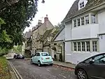 6 St Peter's Hill |
| 4 St Mary's Place | Stamford, South Kesteven | House | Late 18th century | 22 May 1954 | TF0307307023 52°39′04″N 0°28′40″W |
1360027 | |
| 47–50 St Martin's | Stamford, South Kesteven | House | Early 18th century | 22 May 1954 | TF0313106670 52°38′53″N 0°28′37″W |
1360411 | |
| 66 and 67 St Martins | Stamford, South Kesteven | House | 17th century | 22 May 1954 | TF0306506815 52°38′57″N 0°28′41″W |
1360414 | |
| 30 St Martin's | Stamford, South Kesteven | House | Mid 18th century | 22 May 1954 | TF0317006648 52°38′52″N 0°28′35″W |
1360406 | |
| 4 Austin Street | Stamford, South Kesteven | House | Mid 18th century | 22 May 1954 | TF0269406973 52°39′03″N 0°29′00″W |
1365616 | |
| 3 All Saints' Place | Stamford, South Kesteven | House | Early 18th century | 22 May 1954 | TF0286307191 52°39′10″N 0°28′51″W |
1360360 |  3 All Saints' Place |
| 35 St Martin's | Stamford, South Kesteven | House | Early-mid 18th century | 22 May 1954 | TF0319906586 52°38′50″N 0°28′34″W |
1360408 | |
| 18 Broad Street | Stamford, South Kesteven | House | Late 18th century | 22 May 1954 | TF0314507320 52°39′14″N 0°28′36″W |
1360374 | |
| 14 and 15 St George's Square | Stamford, South Kesteven | House | Late 17th century | 22 May 1954 | TF0323807049 52°39′05″N 0°28′31″W |
1360397 | |
| 19 Broad Street | Stamford, South Kesteven | House | Mid 18th century | 22 May 1954 | TF0315007325 52°39′14″N 0°28′36″W |
1062254 | |
| 16 Barn Hill | Stamford, South Kesteven | House | Late 16th century | 22 May 1954 | TF0283507209 52°39′10″N 0°28′53″W |
1360351 | 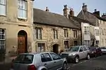 16 Barn Hill |
| 12 St Paul's Street | Stamford, South Kesteven | House | 17th century | 22 May 1954 | TF0322807302 52°39′13″N 0°28′32″W |
1062942 | |
| 14 Barn Hill | Stamford, South Kesteven | House | Early 19th century | 22 May 1954 | TF0281207215 52°39′11″N 0°28′54″W |
1147446 |  14 Barn Hill |
| 51 St Martin's | Stamford, South Kesteven | House | Early 18th century | 22 May 1954 | TF0312006682 52°38′53″N 0°28′38″W |
1169273 | |
| 7 High Street | Stamford, South Kesteven | Shop | Late 18th century | 22 May 1954 | TF0295807150 52°39′08″N 0°28′46″W |
1147799 | .jpg.webp) 7 High Street |
| 25 Broad Street | Stamford, South Kesteven | House | Mid 18th century | 22 May 1954 | TF0314207298 52°39′13″N 0°28′36″W |
1360375 | |
| 52 Broad Street | Stamford, South Kesteven | House | Mid 18th century | 22 May 1954 | TF0292207182 52°39′09″N 0°28′48″W |
1360378 | |
| 13 Barn Hill | Stamford, South Kesteven | House | 1740 | 22 May 1954 | TF0280007223 52°39′11″N 0°28′54″W |
1360350 | 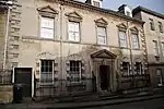 13 Barn Hill |
| 21 and 21a High Street | Stamford, South Kesteven | House | Mid 18th century | 22 May 1954 | TF0303607188 52°39′10″N 0°28′42″W |
1360401 | |
| 23 and 24 High Street | Stamford, South Kesteven | Shop | 1904 | 22 May 1954 | TF0306207216 52°39′10″N 0°28′40″W |
1062232 | |
| Gate, Screen Wall and Balustrade to West of Stoke Rochford Hall | Stoke Rochford Park, Stoke Rochford, South Kesteven | Balustrade | 1841-5 | 9 January 1987 | SK9180628016 52°50′31″N 0°38′18″W |
1306948 | |
| Obelisk, Approximately 250 Metres West North West of Stoke Rochford Hall | Stoke Rochford Park, Stoke Rochford, South Kesteven | Obelisk | 1847 | 14 July 1978 | SK9158828127 52°50′34″N 0°38′30″W |
1062294 | 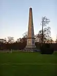 Obelisk, Approximately 250 Metres West North West of Stoke Rochford Hall |
| Church of St. Martin | Stubton, South Kesteven | Parish Church | 1799 | 20 September 1966 | SK8747648779 53°01′45″N 0°41′50″W |
1360092 | 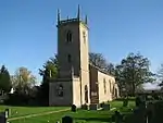 Church of St. Martin |
| Castle Farm House | Swayfield, South Kesteven | Farmhouse | c. 1600 | 30 October 1968 | SK9924822620 52°47′31″N 0°31′47″W |
1062773 | |
| Church of St Nicholas | Swayfield, South Kesteven | Parish Church | 12th century | 30 October 1968 | SK9932422644 52°47′32″N 0°31′43″W |
1360127 | 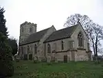 Church of St Nicholas |
| Parish Church of St Mary | Syston, South Kesteven | Parish Church | 11th century | 20 September 1966 | SK9297940941 52°57′28″N 0°37′02″W |
1147012 | 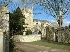 Parish Church of St Mary |
| Bridge over River Welland | Uffington, South Kesteven | Road Bridge | Late 17th century | 22 June 1987 | TF0663006928 52°38′59″N 0°25′31″W |
1317255 | 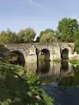 Bridge over River Welland |
| Gates Piers and Walls to Churchyard | Uffington, South Kesteven | Gate | Late 17th century | 30 October 1968 | TF0616507660 52°39′23″N 0°25′55″W |
1062589 | |
| Gates, Piers and Wall to Demolished Uffington House | Uffington, South Kesteven | Gate | 19th century | 30 October 1968 | TF0616807646 52°39′22″N 0°25′55″W |
1165717 | |
| Molecey's Mill and the Granary | West Deeping, South Kesteven | House | 17th century | 21 November 1973 | TF1245209821 52°40′28″N 0°20′18″W |
1360193 | .jpg.webp) Molecey's Mill and the Granary |
| The Manor House | West Deeping, South Kesteven | House | 15th century | 30 October 1968 | TF1123508681 52°39′52″N 0°21′24″W |
1062601 | |
| Church of St James | Westborough and Dry Doddington, South Kesteven | Parish Church | Early 12th century | 20 September 1966 | SK8498146610 53°00′36″N 0°44′06″W |
1253449 | 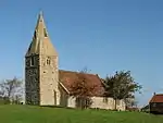 Church of St James |
| The Old Rectory | Westborough and Dry Doddington, South Kesteven | House | 1984 | 19 February 1952 | SK8506544466 52°59′27″N 0°44′03″W |
1253451 | |
| Garden Wall and Doorway at Grantham House | Grantham | Garden Wall | 13th century | 20 April 1972 | SK9154436112 52°54′53″N 0°38′24″W |
1062509 | |
| George Hotel, Grantham | Grantham | Inn | Medieval | 8 May 1950 | SK9136235849 52°54′44″N 0°38′34″W |
1360255 | 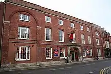 George Hotel, Grantham |
| Vine House | South Kesteven | House | 1764 | 8 May 1950 | SK9136836050 52°54′51″N 0°38′34″W |
1360248 | 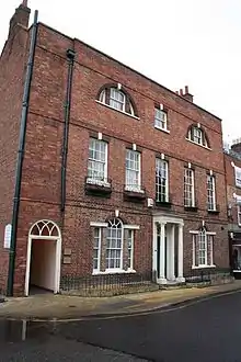 Vine House |
| War Memorial in the Churchyard of Church of St Wulfram | Grantham, South Kesteven | War Memorial | 1920 | 20 April 1972 | SK9143636144 52°54′54″N 0°38′30″W |
1062502 | 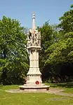 War Memorial in the Churchyard of Church of St Wulfram |
Notes
- The date given is the date used by Historic England as significant for the initial building or that of an important part in the structure's description.
- Sometimes known as OSGB36, the grid reference is based on the British national grid reference system used by the Ordnance Survey.
- The "List Entry Number" is a unique number assigned to each listed building and scheduled monument by Historic England.
External links
![]() Media related to Grade II* listed buildings in South Kesteven District at Wikimedia Commons
Media related to Grade II* listed buildings in South Kesteven District at Wikimedia Commons
This article is issued from Wikipedia. The text is licensed under Creative Commons - Attribution - Sharealike. Additional terms may apply for the media files.