Grade II* listed buildings in Stafford (borough)
There are over 20,000 Grade II* listed buildings in England. This page is a list of these buildings in the district of Stafford in Staffordshire.
Stafford
| Name | Location | Type | Completed [note 1] | Date designated | Grid ref.[note 2] Geo-coordinates |
Entry number [note 3] | Image |
|---|---|---|---|---|---|---|---|
| Church of St Michael and All Angels | Adbaston, Stafford | Church | 13th century | 15 January 1968 | SJ7621927921 52°50′54″N 2°21′16″W |
1116854 | 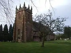 Church of St Michael and All Angels |
| Church of St Editha | Church Eaton, Stafford | Church | Late 12th century | 15 January 1968 | SJ8486817624 52°45′22″N 2°13′32″W |
1319807 | 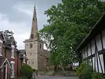 Church of St Editha |
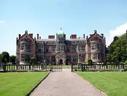
| Bishton Hall | Bishton, Colwich, Stafford | Country House | Mid 18th century | 17 March 1953 | SK0239220701 52°47′02″N 1°57′58″W |
1116588 | _-_geograph.org.uk_-_1441773.jpg.webp) Bishton Hall |
| Doric Screen Garden Walls Terrace and Parterre Curb North of Bishton Hall | Bishton, Colwich, Stafford | Garden Wall | 1840s | 21 June 1995 | SK0237420865 52°47′07″N 1°57′58″W |
1273003 |  |
| Farmhouse of Shugborough Park Farm | Colwich, Stafford | Farmhouse | 1803-1806 | 12 December 1977 | SJ9915321864 52°47′40″N 2°00′50″W |
1258625 | .jpg.webp) Farmhouse of Shugborough Park Farm |
| Hay Barn and Cottages to the West of White Barn Farm | Shugborough Estate, Colwich, Stafford | House | Early 19th century | 21 October 1988 | SJ9886421382 52°47′24″N 2°01′06″W |
1258843 | |
| Parish Church of St Michael and All Angels | Colwich, Stafford | Church | Late 13th century | 15 January 1968 | SK0108621125 52°47′16″N 1°59′07″W |
1116585 | 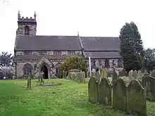 Parish Church of St Michael and All Angels |
| Shepherd's Monument at Shugborough Hall | Colwich, Stafford | Garden Ornament | 17 March 1953 | SJ9925422643 52°48′05″N 2°00′45″W |
1374124 | | |
| South Range of Outbuildings of Shugborough Park Farm | Shugborough Park, Colwich, Stafford | Courtyard | 1803-1806 | 12 December 1977 | SJ9911121857 52°47′39″N 2°00′53″W |
1273324 | |
| Temple of the Winds at Shugborough Hall to North East of the House | Colwich, Stafford | Garden Temple | 18th century | 17 March 1953 | SJ9917921927 52°47′42″N 2°00′49″W |
1065768 | .jpg.webp) Temple of the Winds at Shugborough Hall to North East of the House |
| Walled Garden and Gardeners Cottage | Shugborough Estate, Colwich, Stafford | Estate Cottage | c. 1806 | 21 October 1988 | SJ9911221659 52°47′33″N 2°00′53″W |
1273250 | |
| White Barn Farm | Shugborough Estate, Colwich, Stafford | House | c. 1806 | 21 October 1988 | SJ9889321358 52°47′23″N 2°01′04″W |
1258842 | |
| Charnes Hall | Wetwood, Eccleshall, Stafford | Country House | Post 1650 | 10 January 1953 | SJ7794033829 52°54′05″N 2°19′46″W |
1039015 | .jpg.webp) Charnes Hall |
| Church of St Chad | Slindon, Eccleshall, Stafford | Church | 1894 | 24 January 1967 | SJ8276132216 52°53′14″N 2°15′28″W |
1039048 | _St_Chad's_Church_-_geograph.org.uk_-_69758.jpg.webp) Church of St Chad |
| Eccleshall Castle | Eccleshall, Stafford | Castle | c. 1695 | 10 January 1953 | SJ8280129557 52°51′48″N 2°15′25″W |
1039062 | |
| Range of Outbuildings at West Side of Farmyard flanking Gateway and Range of Cowsheds and Barns on North Side of Farmyard | Gerrards Bromley, Eccleshall, Stafford | Cow House | Late 16th century | 24 January 1967 | SJ7746234792 52°54′36″N 2°20′12″W |
1188037 | |
| Tower at Eccleshall Castle | Eccleshall, Stafford | Tower | 14th century | 10 January 1953 | SJ8286829582 52°51′48″N 2°15′21″W |
1374163 | |
| Church of St Mary | Ellenhall, Stafford | Church | 12th-century origins | 15 January 1968 | SJ8411226529 52°50′10″N 2°14′14″W |
1242638 | 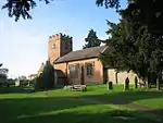 Church of St Mary |
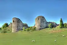
| Tower at Ranton Abbey | Ellenhall, Stafford | Church | LATE MEDIEVAL | 17 March 1953 | SJ8382224278 52°48′57″N 2°14′29″W |
1259926 | 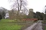 Tower at Ranton Abbey |
| Aqualate Hall | Forton, Stafford | House | 18th century | 17 March 1953 | SJ7735219709 52°46′28″N 2°20′14″W |
1259928 | |
| Church of All Saints | Forton, Stafford | Church | 12th century | 15 January 1968 | SJ7552121188 52°47′16″N 2°21′52″W |
1242640 | 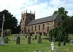 Church of All Saints |
| Forton Hall | Forton, Stafford | House | 1665 | 15 January 1968 | SJ7548521162 52°47′15″N 2°21′54″W |
1242679 | |
| Church of St Peter | Gayton, Stafford | Church | 13th century | 15 January 1968 | SJ9784128424 52°51′12″N 2°02′01″W |
1242644 | 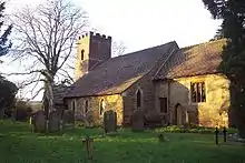 Church of St Peter |
| Church of St Giles | Haughton, Stafford | Church | 14th century | 15 January 1968 | SJ8657020485 52°46′54″N 2°12′02″W |
1242776 | 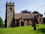 Church of St Giles |
| Haughton Old Hall | Haughton, Stafford | House | Later | 17 March 1953 | SJ8636020649 52°47′00″N 2°12′13″W |
1242778 | |
| Batchacre Hall | High Offley, Stafford | House | 18th century | 17 March 1953 | SJ7540925436 52°49′33″N 2°21′59″W |
1242843 | 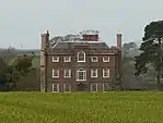 Batchacre Hall |
| Ingestre Hall | Ingestre, Stafford | House | Early 17th century | 17 March 1953 | SJ9759424695 52°49′11″N 2°02′14″W |
1242893 | |
| Church of All Saints | Milwich, Stafford | Church | Perpendicular | 24 January 1967 | SJ9711331979 52°53′07″N 2°02′40″W |
1294230 |  Church of All Saints |
| Gates, Gate Standards and Side Screens Fronting North Facade of Sandon Hall | Sandon, Sandon and Burston, Stafford | Gate | Early 18th century | 25 April 1980 | SJ9567228747 52°51′22″N 2°03′57″W |
1039000 | |
| Pitts Column | Sandon, Sandon and Burston, Stafford | Commemorative Monument | 1806 | 10 January 1953 | SJ9632128168 52°51′04″N 2°03′22″W |
1189785 |  Pitts Column |
| Sandon Hall | Sandon, Sandon and Burston, Stafford | Country House | 1852 | 10 January 1953 | SJ9567828696 52°51′21″N 2°03′56″W |
1189732 | 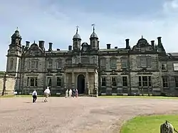 Sandon Hall |
| Trentham Tower | Sandon, Sandon and Burston, Stafford | Folly | c. 1840 | 10 January 1953 | SJ9618729203 52°51′37″N 2°03′29″W |
1189768 | .jpg.webp) Trentham Tower |
| Church of St Chad | Seighford, Stafford | Church | C14-C15 | 15 January 1968 | SJ8824424994 52°49′20″N 2°10′33″W |
1258080 | 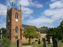 Church of St Chad |
| Clanford Hall | Seighford, Stafford | House | Modern | 17 March 1953 | SJ8717824423 52°49′02″N 2°11′30″W |
1258088 | 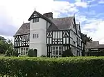 Clanford Hall |
| Church of St Michael | Stone, Stafford | Bust | 1758 | 9 March 1949 | SJ9046033814 52°54′06″N 2°08′36″W |
1196733 | 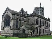 Church of St Michael |
| Crompton Tomb about 52m South West of Church of St Michael | Stone, Stafford | Chest Tomb | 1603-26 | 27 July 1972 | SJ9038633786 52°54′05″N 2°08′40″W |
1196734 | 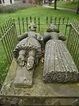 Crompton Tomb about 52m South West of Church of St Michael |
| Crown Hotel | Stone, Stafford | Hotel | 1778 | 9 March 1949 | SJ9019233868 52°54′08″N 2°08′50″W |
1196742 | 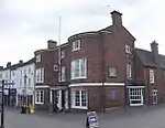 Crown Hotel |
| Jervis Mausoleum about 5m East of Church of St Michael | Stone, Stafford | Plaque | c. 1760 | 27 July 1972 | SJ9048833818 52°54′06″N 2°08′34″W |
1196736 | 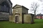 Jervis Mausoleum about 5m East of Church of St Michael |
| The Priory | Stone, Stafford | House | Early to mid 18th century | 9 March 1949 | SJ9040133778 52°54′05″N 2°08′39″W |
1219144 | 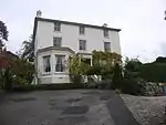 The Priory |
| Walton House and attached Walls | Stone, Stafford | House | 16th Century and later | 9 March 1949 | SJ9023833135 52°53′44″N 2°08′48″W |
1219285 | |
| Chapel of St Marys Abbey | Oulton, Stone Rural, Stafford | Roman Catholic Chapel | 1854 | 25 April 1980 | SJ9081935616 52°55′04″N 2°08′17″W |
1038978 | |
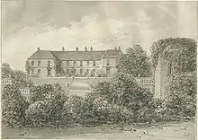
| Meaford Hall, the Manor House | Meaford, Stone Rural, Stafford | Country House | c. 1830 | 24 January 1967 | SJ8888935618 52°55′04″N 2°10′00″W |
1374198 | |
| Meaford Hall, the Nursery House | Meaford, Stone Rural, Stafford | Country House | Early 18th century | 24 January 1967 | SJ8890135583 52°55′03″N 2°09′59″W |
1038974 | |
| Chartley Castle | Stowe-by-Chartley, Stafford | Castle | Early 13th century | 15 January 1968 | SK0106928501 52°51′14″N 1°59′08″W |
1258139 | |
| Church of St John the Baptist | Stowe-by-Chartley, Stafford | Church | 13th century | 15 January 1968 | SK0032827362 52°50′38″N 1°59′48″W |
1273551 | 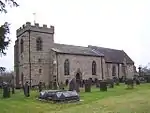 Church of St John the Baptist |
| Chapel of Our Lady of the Assumption | Swynnerton, Stafford | Roman Catholic Chapel | 1868-9 | 25 April 1980 | SJ8516735463 52°54′59″N 2°13′19″W |
1190309 | .jpg.webp) Chapel of Our Lady of the Assumption |
| Church of St Mary and All Saints | Trentham Gardens, Swynnerton, Stafford | Church | 1838 | 24 January 1967 | SJ8653940907 52°57′55″N 2°12′07″W |
1190214 | 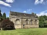 Church of St Mary and All Saints |
| Hatton Water Pumping Station and Chimney | Hatton, Swynnerton, Stafford | Boiler House | 1907 | 25 April 1980 | SJ8293036994 52°55′48″N 2°15′19″W |
1374201 | 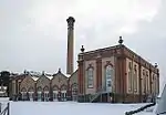 Hatton Water Pumping Station and Chimney |
| Perseus Statue | Trentham Gardens, Swynnerton, Stafford | Statue | c. 1840 | 25 April 1980 | SJ8655140583 52°57′45″N 2°12′06″W |
1374226 | .jpg.webp) Perseus Statue |
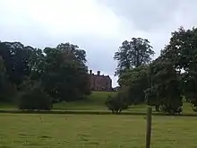
| Remains of Trentham Hall, the Grand Entrance and Orangery | Trentham Gardens, Swynnerton, Stafford | Country House | 1833-42 | 24 January 1967 | SJ8649740883 52°57′54″N 2°12′09″W |
1190243 | 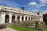 Remains of Trentham Hall, the Grand Entrance and Orangery |
| Sutherland Monument | Trentham, Swynnerton, Stafford | Column | 1836 | 10 January 1953 | SJ8689038846 52°56′49″N 2°11′48″W |
1038951 | |
| St Andrew's Church | Weston, Stafford | Parish Church | Early 13th century | 15 January 1968 | SJ9743127112 52°50′29″N 2°02′22″W |
1273479 | 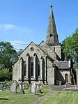 St Andrew's Church |
| Weston Hall | Weston, Stafford | House | 17th century | 17 March 1953 | SJ9662827008 52°50′26″N 2°03′05″W |
1258043 | 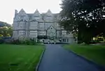 Weston Hall |
| Church of Holy Trinity | Baswich, Stafford | Church | 13th century | 16 January 1951 | SJ9438822297 52°47′54″N 2°05′05″W |
1195367 | 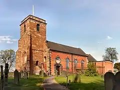 Church of Holy Trinity |
| Church of St Chad | Stafford | Tower | 14th century | 16 January 1951 | SJ9225523185 52°48′22″N 2°06′59″W |
1212227 | 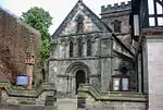 Church of St Chad |
| Church of St Mary | Castle Church, Stafford | Church | 15th century | 16 January 1951 | SJ9058922156 52°47′49″N 2°08′28″W |
1195376 | 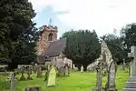 Church of St Mary |
| Clarks, Three Cooks and Part of Swan Hotel | Stafford | House | 18th century | 16 January 1951 | SJ9219923186 52°48′22″N 2°07′02″W |
1298172 | |
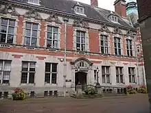
| County Buildings and Judges House | Stafford | Office | 1879 | 17 December 1971 | SJ9226723264 52°48′25″N 2°06′58″W |
1298178 | |
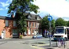
| Eastgate House (Registrar's Office, part) | Stafford | House | Early 18th century | 16 January 1951 | SJ9232623271 52°48′25″N 2°06′55″W |
1298148 | 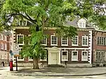 Eastgate House (Registrar's Office, part) |
| Friends' Meeting House | Stafford | Friends Meeting House | 1730 | 16 January 1951 | SJ9202223722 52°48′40″N 2°07′11″W |
1211911 | 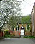 Friends' Meeting House |
| High House | Stafford | House | 1976-86 | 16 January 1951 | SJ9219423198 52°48′23″N 2°07′02″W |
1212192 | 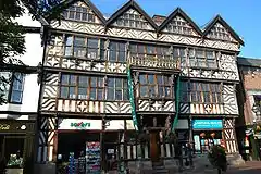 High House |
| Noell's Almshouses and Attached Boundary Wall | Stafford | Almshouse | c. 1660 | 16 January 1951 | SJ9206623063 52°48′18″N 2°07′09″W |
1212519 | 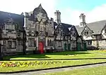 Noell's Almshouses and Attached Boundary Wall |
| Post Office and attached Railings and Gate | Stafford | House | c. 1700 | 29 July 1970 | SJ9223423079 52°48′19″N 2°07′00″W |
1195351 | 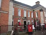 Post Office and attached Railings and Gate |
| Shire Hall and attached Railings, Gates and Lamp Standards | Stafford | Gate | 1795-8 | 16 January 1951 | SJ9223123306 52°48′26″N 2°07′00″W |
1298177 | 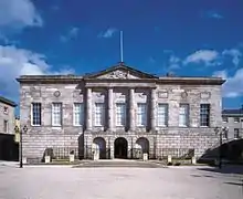 Shire Hall and attached Railings, Gates and Lamp Standards |
| Staffordshire County Staff Club | Stafford | House | Mid 18th century | 16 January 1951 | SJ9235023244 52°48′24″N 2°06′54″W |
1211304 | 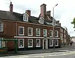 Staffordshire County Staff Club |
| Swan Hotel | Stafford | Courtyard | Pre 1733 | 16 January 1951 | SJ9220423172 52°48′22″N 2°07′02″W |
1195355 | 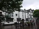 Swan Hotel |
| Upmeads and attached Terrace Walls | Stafford | House | 1908 | 17 December 1971 | SJ9096522344 52°47′55″N 2°08′08″W |
1195363 | |
| William Salt Library | Stafford | House | 18th century | 16 January 1951 | SJ9241423243 52°48′24″N 2°06′50″W |
1298149 |
.jpg.webp)
Notes
- The date given is the date used by Historic England as significant for the initial building or that of an important part in the structure's description.
- Sometimes known as OSGB36, the grid reference is based on the British national grid reference system used by the Ordnance Survey.
- The "List Entry Number" is a unique number assigned to each listed building and scheduled monument by Historic England.
External links
![]() Media related to Grade II* listed buildings in Staffordshire at Wikimedia Commons
Media related to Grade II* listed buildings in Staffordshire at Wikimedia Commons
This article is issued from Wikipedia. The text is licensed under Creative Commons - Attribution - Sharealike. Additional terms may apply for the media files.