Grade II* listed buildings in Swale
There are over 20,000 Grade II* listed buildings in England. This page is a list of these buildings in the district of Swale in Kent.
Swale
| Name | Location | Type | Completed [note 1] | Date designated | Grid ref.[note 2] Geo-coordinates |
Entry number [note 3] | Image |
|---|---|---|---|---|---|---|---|
| Church of St Leonard | Badlesmere, Swale | Parish Church | 13th century | 24 January 1967 | TR0138755096 51°15′34″N 0°53′06″E |
1069922 | 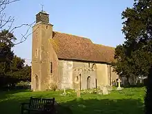 Church of St Leonard |
| Borden Hall | Borden | House | 17th century | 27 August 1952 | TQ8820963019 51°20′06″N 0°42′02″E |
1185884 |  |
| Hook's Hole | Borden | Hall House | 15th century | 27 August 1952 | TQ8760863898 51°20′36″N 0°41′32″E |
1069424 | |
| Olstede | Borden | House | 17th century | 27 August 1952 | TQ8755863860 51°20′34″N 0°41′30″E |
1069383 | |
| Yew Tree Cottage | Borden | House | 16th century to 17th century | 24 January 1967 | TQ8686262154 51°19′40″N 0°40′51″E |
1343887 | |
| Colkins | Clockhouse, Boughton under Blean | House | 1729 | 27 August 1952 | TR0336059256 51°17′46″N 0°54′56″E |
1069131 |  Colkins |
| Hall Cottage | Boughton under Blean | Wealden House | 16th century | 24 January 1967 | TR0559257704 51°16′53″N 0°56′48″E |
1344002 | 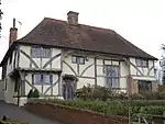 Hall Cottage |
| Nash Court | Boughton under Blean | House | Restored before 1878 | 21 May 1986 | TR0470459936 51°18′06″N 0°56′07″E |
1069133 | |
| Style House | Boughton Street, Boughton under Blean | Continuous Jetty House | 16th century | 27 August 1952 | TR0554359470 51°17′50″N 0°56′49″E |
1069156 | |
| Walls about 20 to 60 Metres South East of Colkins | Clockhouse, Boughton under Blean | Wall | Early 18th century | 21 May 1986 | TR0340159215 51°17′45″N 0°54′58″E |
1069132 | Walls about 20 to 60 Metres South East of Colkins |
| Walnut Tree House | Boughton under Blean | Wealden House | 15th century | 27 August 1952 | TR0546857799 51°16′56″N 0°56′42″E |
1325973 |  Walnut Tree House |
| Bexon Manor | Bexon, Bredgar | Jettied House | 15th century | 27 August 1952 | TQ8898459478 51°18′11″N 0°42′35″E |
1069395 |  Bexon Manor |
| Brickwall and Railings to Forecourt | Bredgar | Timber Framed House | 17th century | 24 January 1967 | TQ8796360251 51°18′37″N 0°41′44″E |
1299305 | |
| Chantry House | Bredgar | House | 1984 | 24 January 1967 | TQ8798260406 51°18′42″N 0°41′45″E |
1069369 |  Chantry House |
| Swanton Street Farmhouse | Swanton Street, Bredgar | Farmhouse | Earlier | 27 August 1952 | TQ8755059319 51°18′08″N 0°41′21″E |
1069371 | |
| Ruins of Shurland Hall or Castle | Eastchurch | Castle | Earlier | 14 May 1952 | TQ9942171550 51°24′28″N 0°51′58″E |
1258505 |  Ruins of Shurland Hall or Castle |
| Box Cottage | Eastling | House | Early 19th century | 24 January 1967 | TQ9637856494 51°16′25″N 0°48′50″E |
1054867 | |
| Church of St Mary | Eastling | Parish Church | 12th century | 24 January 1967 | TQ9652256555 51°16′27″N 0°48′58″E |
1343974 |  Church of St Mary |
| Eastling Manor | Eastling | House | 1616 | 27 August 1952 | TQ9626356518 51°16′26″N 0°48′45″E |
1069239 | 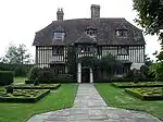 Eastling Manor |
| Abbey Farmhouse | Faversham | Farmhouse | 13th century or Early 14th century | 3 August 1972 | TR0209561831 51°19′11″N 0°53′56″E |
1060995 | |
| Arden's House | Faversham | Abbey | Presumably Medieval | 29 July 1950 | TR0182861729 51°19′08″N 0°53′42″E |
1186199 | .jpg.webp) Arden's House |
| Church of St Catherine | Preston-by-Faversham, Faversham | Parish Church | Pre-conqust origins | 29 July 1950 | TR0168260768 51°18′37″N 0°53′32″E |
1115766 | 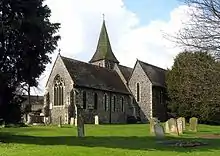 Church of St Catherine |
| Cooksditch | Faversham | House | 18th century | 29 July 1950 | TR0177261320 51°18′55″N 0°53′38″E |
1069457 | |
| Davington Priory | Davington, Faversham | Cloister | Founded 1153 | 29 July 1950 | TR0109261743 51°19′09″N 0°53′04″E |
1069404 | |
| Faversham Abbey Major Barn | Faversham | Abbey | c. 1500 | 3 August 1972 | TR0211161762 51°19′09″N 0°53′57″E |
1344267 | |
| Fremlins Offices (including East Wing and Billiard Room) | Faversham | House | 18th century | 29 July 1950 | TR0166361512 51°19′01″N 0°53′33″E |
1069489 | |
| Gillett's Granaries | Faversham | Granary | 29 July 1950 | TR0196361940 51°19′15″N 0°53′49″E |
1115576 | | |
| Mediaeval Stables at Abbey Farm | Faversham | Stable | 14th century or 15th century | 17 January 1989 | TR0216461803 51°19′10″N 0°53′59″E |
1268252 | |
| Queen Court Farmhouse and Outbuildings | Ospringe, Faversham | Farmhouse | 15th century | 29 July 1950 | TR0015560464 51°18′29″N 0°52′13″E |
1360992 |  Queen Court Farmhouse and Outbuildings |
| The Guildhall | Faversham | Local Government Office | 1603 | 29 July 1950 | TR0157161382 51°18′57″N 0°53′28″E |
1343844 |  The Guildhall |
| The Maison Dieu Museum | Ospringe, Faversham | Public House | 1950 | 29 July 1950 | TR0036260855 51°18′41″N 0°52′25″E |
1069431 | |
| Faversham Munitions Explosion Memorial | Faversham | Grave | 1917 | 27 September 1989 | TR0250360871 51°18′41″N 0°54′16″E |
1261010 | |
| The Masonic Hall | Faversham | Grammar School | Founded 1527 | 29 July 1950 | TR0185161636 51°19′05″N 0°53′43″E |
1344229 | |
| The Training Ship Hasarde | Faversham | Warehouse | 15th century | 29 July 1950 | TR0158461615 51°19′05″N 0°53′29″E |
1116391 | |
| 87 To 92 Abbey Street | Faversham | House | 18th century | 29 July 1950 | TR0177361664 51°19′06″N 0°53′39″E |
1061013 | |
| 121 West Street | Faversham | House | Dated 1697 | 29 July 1950 | TR0153261386 51°18′57″N 0°53′26″E |
1067608 | |
| 1 The Market Place | Faversham | House | 18th century | 29 July 1950 | TR0154861377 51°18′57″N 0°53′27″E |
1069462 | |
| 5 and 6 The Market Place | Faversham | Jettied House | 15th century possibly earlier | 29 July 1950 | TR0156261398 51°18′58″N 0°53′28″E |
1343845 | |
| 15 Ospringe Street | Ospringe, Faversham | Hospital | 1230 | 29 July 1950 | TR0038060850 51°18′41″N 0°52′25″E |
1069430 | |
| 81 Abbey Street | Faversham | Abbey | 15th century | 29 July 1950 | TR0181761715 51°19′07″N 0°53′41″E |
1344235 | |
| 84 Abbey Street | Faversham | House | c. 1589 | 29 July 1950 | TR0179261682 51°19′06″N 0°53′40″E |
1240604 | |
| Ewell Farmhouse | Graveney with Goodnestone | Hall House | 14th century or 15th century | 24 January 1967 | TR0353760848 51°18′37″N 0°55′08″E |
1325225 | |
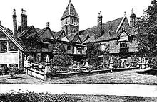
| Goodnestone Court | Graveney with Goodnestone | Continuous Jetty House | 15th century | 27 August 1952 | TR0447661657 51°19′02″N 0°55′58″E |
1107863 |  Goodnestone Court |
| Barrows Cottages | Hartlip, Swale | House | 18th century | 24 January 1967 | TQ8386164009 51°20′44″N 0°38′19″E |
1319991 | |
| Queendown Warren | Queendown Warren, Hartlip | Continuous Jetty House | c. 1560 | 27 August 1952 | TQ8264563016 51°20′13″N 0°37′14″E |
1069375 | |
| Warren Cottage | Queendown Warren, Hartlip | House | 19th century | 27 November 1984 | TQ8323262875 51°20′08″N 0°37′44″E |
1116349 | |
| Dargate House | Dargate, Hernhill | House | Early 19th century | 24 January 1967 | TR0751861941 51°19′07″N 0°58′36″E |
1344025 | |
| Manor House | Hernhill Green, Hernhill | Continuous Jetty House | 15th century | 24 January 1967 | TR0653860684 51°18′28″N 0°57′43″E |
1323023 |  Manor House |
| Church of St Laurence | Leaveland | Parish Church | 13th century | 24 January 1967 | TR0048854850 51°15′27″N 0°52′19″E |
1054051 | 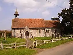 Church of St Laurence |
| Leaveland Court | Leaveland | Continuous Jetty House | 15th century | 27 August 1952 | TR0038954852 51°15′27″N 0°52′14″E |
1054067 |  Leaveland Court |
| Church of St Thomas the Apostle | Harty, Leysdown | Church | 11th century or early 12th century | 27 June 1963 | TR0231366279 51°21′34″N 0°54′16″E |
1258076 | 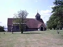 Church of St Thomas the Apostle |
| Bogle with Garden Wall | Lynsted with Kingsdown | House | c. 1643 | 27 August 1952 | TQ9474261452 51°19′08″N 0°47′36″E |
1106389 |  Bogle with Garden Wall |
| Bumpit | Lynsted with Kingsdown | House | 16th century | 24 January 1967 | TQ9499161193 51°18′59″N 0°47′48″E |
1334371 | |
| Claxfield Farmhouse | Lynsted with Kingsdown | House | Later | 21 March 1985 | TQ9443562562 51°19′44″N 0°47′22″E |
1343922 |  Claxfield Farmhouse |
| Lynsted Park and adjacent Garden Walls | Lynsted Park, Lynsted with Kingsdown | House | 1599 | 27 August 1952 | TQ9471359655 51°18′10″N 0°47′31″E |
1069310 | |
| Sunderland Farmhouse | Lynsted with Kingsdown | Continuous Jetty House | 16th century | 27 August 1952 | TQ9425961657 51°19′15″N 0°47′11″E |
1343923 |  Sunderland Farmhouse |
| The Malthouse | Lynsted with Kingsdown | Continuous Jetty House | Late 16th century | 27 August 1952 | TQ9490361904 51°19′22″N 0°47′45″E |
1343929 | 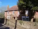 The Malthouse |
| Church of St Mary and the Holy Cross | Milstead | Parish Church | C12-C13 | 24 January 1967 | TQ9035858760 51°17′46″N 0°43′44″E |
1069286 | 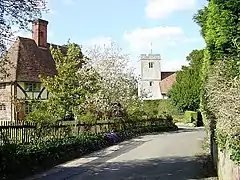 Church of St Mary and the Holy Cross |
| Milstead Manor | Milstead | Continuous Jetty House | 16th century | 27 August 1952 | TQ9041458726 51°17′45″N 0°43′47″E |
1343916 |  Milstead Manor |
| Calico House | Newnham | House | 18th century | 27 August 1952 | TQ9520857612 51°17′03″N 0°47′52″E |
1069247 | 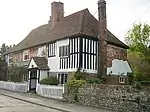 Calico House |
| Champion Court | Newnham | House | 1952 | 27 August 1952 | TQ9558657984 51°17′15″N 0°48′12″E |
1343938 | |
| Church of St Peter and St Paul | Newnham | Parish Church | c. 1200 | 24 January 1967 | TQ9540157627 51°17′03″N 0°48′02″E |
1055749 | 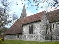 Church of St Peter and St Paul |
| Foxenden Manor | Foxenden, Newnham | Farmhouse | 1604 | 27 August 1952 | TQ9445156554 51°16′30″N 0°47′11″E |
1366585 | 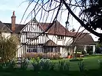 Foxenden Manor |
| Provender | Norton, Buckland and Stone | Jettied House | 16th century | 27 August 1952 | TQ9737960801 51°18′43″N 0°49′51″E |
1374517 |  Provender |
| Homeside with Railings to Forecourt | Oare | House | Early 19th century | 21 May 1986 | TR0065362964 51°19′49″N 0°52′44″E |
1344016 | |
| Church of St Peter and St Paul | Ospringe | Parish Church | c. 1200 | 29 July 1950 | TR0002860311 51°18′24″N 0°52′06″E |
1343988 | 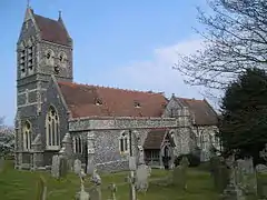 Church of St Peter and St Paul |
| The Old Vicarage | Ospringe | House | 17th century | 3 August 1972 | TR0008960190 51°18′20″N 0°52′09″E |
1354736 | |
| Parish Church of the Holy Trinity | Queenborough | Tower | West tower dating from 11th century | 19 October 1951 | TQ9091772306 51°25′03″N 0°44′39″E |
1258500 | 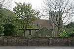 Parish Church of the Holy Trinity |
| Saffery Farmhouse | Owen's Court, Selling | Cross Wing House | 15th century | 27 August 1952 | TR0297257796 51°16′59″N 0°54′33″E |
1344044 | 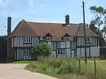 Saffery Farmhouse |
| Church of St James | Sheldwich | Parish Church | 12th century | 24 January 1967 | TR0113356863 51°16′31″N 0°52′56″E |
1049130 | 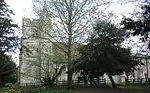 Church of St James |
| Throwley House | Sheldwich | House | 17th century or 18th century | 2 November 1978 | TR0105556839 51°16′31″N 0°52′52″E |
1344050 | |
| Church of St Mary | Stalisfield | Parish Church | 13th century | 24 January 1967 | TQ9673852434 51°14′14″N 0°49′01″E |
1025295 | 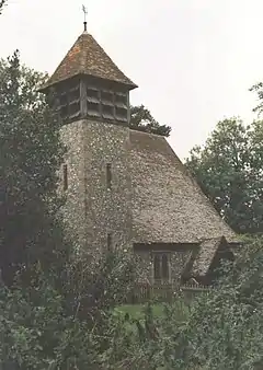 Church of St Mary |
| Frognal Farmhouse and Garden Wall | Teynham | House | 1668 | 27 August 1952 | TQ9484063391 51°20′10″N 0°47′45″E |
1069261 | .jpg.webp) Frognal Farmhouse and Garden Wall |
| Garden Pavilion at Belmont Park (TQ 984 567) | Belmont, Throwley | Summerhouse | 18th century | 28 August 1986 | TQ9836556708 51°16′30″N 0°50′33″E |
1069173 | |
| Snoad Street Manor | Snoadstreet, Throwley | House | 15th century or earlier | 27 August 1952 | TQ9921252434 51°14′11″N 0°51′08″E |
1203485 | |
| Bax Farmhouse | Tonge | House | 1567 | 27 August 1952 | TQ9435963823 51°20′25″N 0°47′21″E |
1338557 | |
| Newberry Farmhouse | Tonge | House | 17th century | 24 January 1967 | TQ9279859946 51°18′21″N 0°45′53″E |
1069267 | |
| Gore Farmhouse | Upchurch | Farmhouse | 1984 | 27 November 1984 | TQ8435666516 51°22′04″N 0°38′49″E |
1069318 | |
| Archway House Building Number 23 | Sheerness Dockyard | Carpenters Workshop | 1824-1830 | 1 August 1968 | TQ9106275137 51°26′35″N 0°44′52″E |
1258986 | |
| Church of St Michael | Sittingbourne | School | Change of use early 19th century | 10 September 1951 | TQ9093463615 51°20′22″N 0°44′23″E |
1061030 | 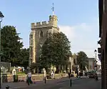 Church of St Michael |
| Former North Saw Pits Building Number 84 | Sheerness Dockyard | Saw Pit | 1828 | 25 April 1994 | TQ9098775361 51°26′42″N 0°44′49″E |
1243244 | |
| Former Royal Dockyard Church and Attached Wall and Railings | Sheerness Dockyard | Gate Pier | 1828 | 7 December 1966 | TQ9146175154 51°26′35″N 0°45′13″E |
1273239 |  Former Royal Dockyard Church and Attached Wall and Railings |
| Former Working Mast House Building Number 26 | Sheerness Dockyard | Boat House | 1821-1826 | 13 August 1999 | TQ9087474922 51°26′28″N 0°44′42″E |
1244509 | |
| Medway Ports Authority Offices (Dockyard House) | Sheerness Dockyard | Office | 1977 | 15 March 1977 | TQ9134775179 51°26′36″N 0°45′07″E |
1258883 | |
| Numbers 1 to 15 and attached Railings | Sheerness Dockyard | House | 1999 | 15 March 1977 | TQ9134375114 51°26′34″N 0°45′07″E |
1258881 | |
| Numbers 1 to 8 Attached Basement Railings, Walls, Coach House and Stables | Sheerness Dockyard | Terrace | 1824-1827 | 15 March 1977 | TQ9147475086 51°26′33″N 0°45′14″E |
1258879 | |
| Walls and Gates of the Boat Basin, Docks Number 4 5 and Slipway | Sheerness Dockyard, Swale | Wall | c. 1814 | 15 March 1977 | TQ9085375334 51°26′41″N 0°44′42″E |
1255552 | |
| The Court House | Milton Regis | Court House | c. 1450 | 10 September 1951 | TQ9037964734 51°20′59″N 0°43′57″E |
1344240 | 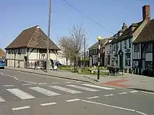 The Court House |
| 49 and 51 High Street | Sittingbourne | House | 18th century | 10 September 1951 | TQ9078463614 51°20′23″N 0°44′16″E |
1352683 | |
| Memorial to the Home of Aviation | Eastchurch | Memorial | 1955 | 30 June 1978 | TQ9883271385 51°24′24″N 0°51′27″E |
1258069 |

.jpg.webp)

Notes
- The date given is the date used by Historic England as significant for the initial building or that of an important part in the structure's description.
- Sometimes known as OSGB36, the grid reference is based on the British national grid reference system used by the Ordnance Survey.
- The "List Entry Number" is a unique number assigned to each listed building and scheduled monument by Historic England.
External links
![]() Media related to Grade II* listed buildings in Kent at Wikimedia Commons
Media related to Grade II* listed buildings in Kent at Wikimedia Commons
This article is issued from Wikipedia. The text is licensed under Creative Commons - Attribution - Sharealike. Additional terms may apply for the media files.