Grade II* listed buildings in Tewkesbury (borough)
There are over 20,000 Grade II* listed buildings in England. This page is a list of these buildings in the district of Tewkesbury in Gloucestershire.
Tewkesbury
| Name | Location | Type | Completed [note 1] | Date designated | Grid ref.[note 2] Geo-coordinates |
Entry number [note 3] | Image |
|---|---|---|---|---|---|---|---|
| Church of St Margaret of Antioch | Alderton, Tewkesbury Borough | Church | Perpendicular | 4 July 1960 | SP0020533178 51°59′49″N 1°59′54″W |
1091731 | 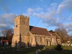 Church of St Margaret of Antioch |
| Dixton Manor | Dixton, Alderton | Manor House | 16th century | 4 July 1960 | SO9845730485 51°58′22″N 2°01′26″W |
1091732 |  |
| Church of St Nicholas | Ashchurch Village, Ashchurch Rural | Anglican Church | 12th century | 4 July 1960 | SO9275833414 51°59′57″N 2°06′25″W |
1153103 | 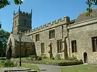 Church of St Nicholas |
| Dovecote circa 75 Metres South East of Manor Farm | Fiddington, Ashchurch Rural | Dovecote | 1637 | 25 February 1987 | SO9207630897 51°58′35″N 2°07′00″W |
1091923 | |
| Manor Farm | Fiddington, Ashchurch Rural | Farmhouse | Late C18-early 19th century | 25 February 1987 | SO9205330957 51°58′37″N 2°07′02″W |
1091922 | |
| The Manor | Aston on Carrant, Ashchurch Rural | House | 1614 | 4 July 1960 | SO9448934542 52°00′33″N 2°04′54″W |
1340054 | 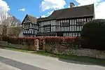 The Manor |
| Ashleworth Manor | White End, Ashleworth | Jettied House | c.1460 or later | 10 January 1955 | SO8189325734 51°55′47″N 2°15′53″W |
1091361 | 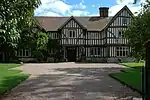 Ashleworth Manor |
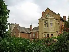
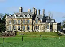
| Foscombe | Ashleworth | Country House | c. 1860 | 26 November 1986 | SO8009126722 51°56′19″N 2°17′28″W |
1340298 | 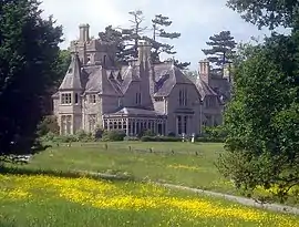 Foscombe |
| Tithe Barn, Ashleworth Court | Ashleworth | Cow House | 19th century | 10 January 1955 | SO8178825205 51°55′30″N 2°15′58″W |
1171121 | 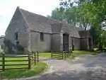 Tithe Barn, Ashleworth Court |
| Dovecote 3m north of Bridge House | Bentham, Badgeworth | Dovecote | 17th century | 15 August 1973 | SO9117716717 51°50′56″N 2°07′46″W |
1304753 | 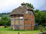 Dovecote 3m north of Bridge House |
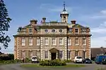
| Cleeve Hall | Bishop's Cleeve | Bishops Palace | c. 1250 | 4 July 1960 | SO9568827627 51°56′50″N 2°03′51″W |
1303966 | 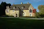 Cleeve Hall |
| Brockworth Court | Brockworth | House | 18th century | 10 January 1955 | SO8912117022 51°51′06″N 2°09′34″W |
1091764 | |
| Tithe Barn about 8m north-east of Brockworth Court | Brockworth | Barn | 19th century | 10 January 1955 | SO8913917069 51°51′08″N 2°09′33″W |
1152564 | 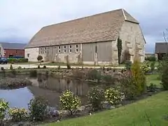 Tithe Barn about 8m north-east of Brockworth Court |
| Buckland Manor Hotel | Buckland Village, Buckland | Country House | 17th century | 4 July 1960 | SP0814135964 52°01′19″N 1°52′58″W |
1091842 |  Buckland Manor Hotel |
| Unidentified Monuments in the Churchyard, about 1.5m north of West End of North Aisle, Church of St Michael | Buckland Village, Buckland | Chest Tomb | 15th century | 7 September 1987 | SP0816736015 52°01′21″N 1°52′57″W |
1091843 | |
| Chaceley Hall | Chaceley | Kitchen | Late 19th century | 10 January 1955 | SO8421430577 51°58′24″N 2°13′52″W |
1304298 | 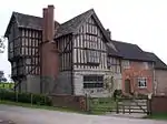 Chaceley Hall |
| Church of St John the Baptist | Chaceley Village, Chaceley | Anglican Church | early-mid 19th century | 10 January 1955 | SO8551130670 51°58′28″N 2°12′44″W |
1091455 | 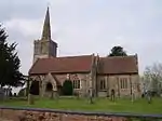 Church of St John the Baptist |
| Grain House Farmhouse | Chaceley Village, Chaceley | Farmhouse | 18th century | 12 August 1985 | SO8545630730 51°58′29″N 2°12′47″W |
1153559 | |
| Caledonia Manor House | Churchdown | House | late C17-C18 | 29 October 1986 | SO8840519898 51°52′39″N 2°10′11″W |
1305066 | |
| Wightfield Manor | Deerhurst | Farmhouse | 1987 | 4 July 1960 | SO8694228724 51°57′25″N 2°11′29″W |
1088690 | 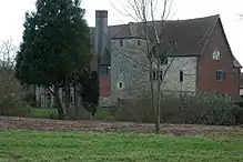 Wightfield Manor |
| Church of St Mary and Corpus Christi | Down Hatherley Village, Down Hatherley | Anglican Church | c. 1860 | 10 January 1955 | SO8678722484 51°54′03″N 2°11′36″W |
1153578 | 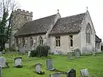 Church of St Mary and Corpus Christi |
| Church of St Catherine | Wormington Village, Dumbleton | Church | Anglo-Saxon | 4 July 1960 | SP0389136431 52°01′35″N 1°56′41″W |
1091676 | 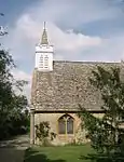 Church of St Catherine |
| Church of St Mary | Little Washbourne, Dumbleton | Former Church | 12th century | 4 July 1960 | SO9891433437 51°59′58″N 2°01′02″W |
1091716 | 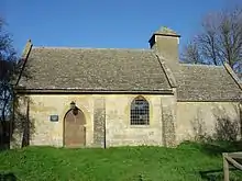 Church of St Mary |
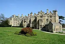
| Dumbleton Hall | Dumbleton Village, Dumbleton | Country House | c. 1830 | 28 August 1987 | SP0132635626 52°01′09″N 1°58′56″W |
1091709 | |
| Church of St Mary the Virgin | Forthampton Village, Forthampton | Anglican Church | 1788 | 10 January 1955 | SO8588432573 51°59′29″N 2°12′25″W |
1340277 | 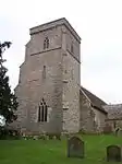 Church of St Mary the Virgin |
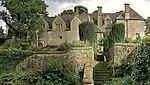
| Forthampton Court | Forthampton | Country House | C12-mid 16th century | 12 August 1985 | SO8701231777 51°59′03″N 2°11′26″W |
1153626 | 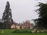 Forthampton Court |
| Beach Hall (the Summer House) circa 5m south of Witcombe Park | Witcombe Park, Great Witcombe | Walled Garden | 1697 | 4 July 1960 | SO9115214434 51°49′42″N 2°07′47″W |
1304582 | |
| Gretton Farmhouse | Gretton | Farmhouse | 16th century | 4 July 1960 | SP0097030291 51°58′16″N 1°59′14″W |
1305102 | |
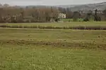
| Hasfield Court | Hasfield | Country House | Late 17th century | 12 August 1985 | SO8251627470 51°56′44″N 2°15′21″W |
1091444 | |
| Church of St Edward | Hawling Village, Hawling | Parish Church | Early 13th century | 4 July 1960 | SP0629322939 51°54′18″N 1°54′36″W |
1091850 | 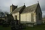 Church of St Edward |
| Church of St Oswald's Tower | Lassington, Highnam | Tower | Late 11th century | 10 January 1955 | SO7960321172 51°53′19″N 2°17′52″W |
1091372 | |
| Church of St Giles | Maisemore | Parish Church | 15th century | 10 January 1955 | SO8138021655 51°53′35″N 2°16′19″W |
1171533 | 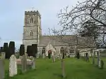 Church of St Giles |
| Maisemore Court, Old Court, New Court | Maisemore | Farmhouse | Early 17th century | 26 November 1986 | SO8139321582 51°53′33″N 2°16′18″W |
1091377 | |
| Church of St Peter | Minsterworth | Parish Church | 1869-70 | 26 November 1986 | SO7731417005 51°51′04″N 2°19′51″W |
1340317 | 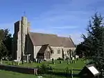 Church of St Peter |
| Church of St Mary | Prior's Norton, Norton | Anglican Church | 1875-76 | 10 January 1955 | SO8655424379 51°55′04″N 2°11′49″W |
1340308 | 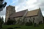 Church of St Mary |
| Church of St Martin de Tours | Woolstone, Oxenton | Church | 14th century | 4 December 1987 | SO9611230244 51°58′14″N 2°03′29″W |
1091692 | 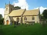 Church of St Martin de Tours |
| Chapel of Ease (St Michael) | Stanley Pontlarge, Prescott | Church | 12th century | 4 July 1960 | SO9992430202 51°58′13″N 2°00′09″W |
1340193 | 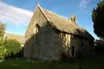 Chapel of Ease (St Michael) |
| The Cottage | Stanley Pontlarge, Prescott | House | Late C15-early 16th century | 4 July 1960 | SO9989830214 51°58′13″N 2°00′10″W |
1091663 | |
| Church of St Lawrence | Sandhurst Village, Sandhurst | Anglican Church | 1858 | 10 January 1955 | SO8279423332 51°54′30″N 2°15′05″W |
1154346 | 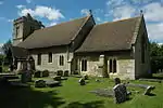 Church of St Lawrence |
| Gate Piers in front of Wallsworth Hall | Sandhurst | Gate Pier | 18th century | 12 August 1985 | SO8417122971 51°54′18″N 2°13′53″W |
1091414 | 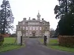 Gate Piers in front of Wallsworth Hall |
| Wallsworth Hall | Sandhurst | Country House | 1753 | 12 August 1985 | SO8411523003 51°54′19″N 2°13′56″W |
1340310 | |
| Church of St Paul | Shurdington | Church | 1655 | 4 July 1960 | SO9211118825 51°52′05″N 2°06′58″W |
1091720 | 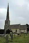 Church of St Paul |
| Snowshill Manor | Snowshill Village, Snowshill | Country House | 17th century | 4 July 1960 | SP0967533841 52°00′11″N 1°51′38″W |
1340081 | |
| Church of the Ascension | Southam | Church | 12th century | 4 December 1987 | SO9698125557 51°55′43″N 2°02′43″W |
1303115 |  Church of the Ascension |
| Manor Farmhouse | Southam | Farmhouse | 1631 | 4 July 1960 | SO9677325660 51°55′46″N 2°02′54″W |
1091667 | |
| Southam Tithe Barn and Shelter Shed | Southam | Barn | C20 | 4 July 1960 | SO9697625598 51°55′44″N 2°02′43″W |
1091668 | 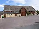 Southam Tithe Barn and Shelter Shed |
| The De La Bere Hotel | Southam | Country House | c. 1500 | 4 July 1960 | SO9722925350 51°55′36″N 2°02′30″W |
1155737 | 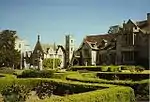 The De La Bere Hotel |
| Old Manor Farmhouse | Stanton | Farmhouse | Late 16th century | 4 July 1960 | SP0682434241 52°00′24″N 1°54′07″W |
1154068 | |
| Stables, Wormington Grange | Stanton | Dwelling | Late 19th century | 4 July 1960 | SP0461934646 52°00′37″N 1°56′03″W |
1091824 | |
| The Manor and Warne Cottage | Stanton | House | Early 16th century | 4 July 1960 | SP0677034191 52°00′22″N 1°54′10″W |
1091838 | |
| Wormington Grange | Stanton | Country House | 1770s | 4 July 1960 | SP0467534570 52°00′34″N 1°56′00″W |
1340084 | |
| Church of St Peter | Stanway Village, Stanway | Church | 1797 | 4 July 1960 | SP0607432364 51°59′23″N 1°54′47″W |
1154342 | 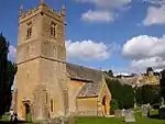 Church of St Peter |
| Papermill Farmhouse | Stanway | Farmhouse | 13th century | 7 September 1987 | SP0714732375 51°59′23″N 1°53′50″W |
1091800 | |
| Pyramid in Grounds of Stanway House, about 300m to the East | Stanway Village, Stanway | Garden Building | 1750 | 7 September 1987 | SP0644632422 51°59′25″N 1°54′27″W |
1303832 | 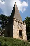 Pyramid in Grounds of Stanway House, about 300m to the East |
| Church of St Catherine | Staverton | church | late C20 | 4 July 1960 | SO8900323598 51°54′39″N 2°09′41″W |
1304748 | 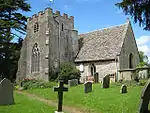 Church of St Catherine |
| Unidentified Monument in the Churchyard of the Church of St John the Baptist, circa 2.5m south of the Porch | Tredington, Stoke Orchard | Chest Tomb | late C17-early 18th century | 25 February 1987 | SO9049729481 51°57′49″N 2°08′23″W |
1091884 | |
| Wadfield House and Side Walls to Forecourt | Sudeley | House | c. 1705 | 4 July 1960 | SP0255826394 51°56′10″N 1°57′51″W |
1091780 | |
| Church of St Margaret | Alstone Village, Teddington | Church | Late 12th century | 4 July 1960 | SO9826232459 51°59′26″N 2°01′36″W |
1340159 | 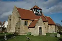 Church of St Margaret |
| Manor Farmhouse | Alstone Village, Teddington | Farmhouse | C20 | 4 December 1987 | SO9827132511 51°59′28″N 2°01′36″W |
1091671 | |
| Abbey Mill | River Avon, Tewkesbury | Banqueting House | 1952 | 4 March 1952 | SO8891732544 51°59′28″N 2°09′46″W |
1201285 | 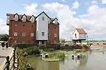 Abbey Mill |
| Avonside | Tewkesbury | Row House | Mid 18th century | 4 March 1952 | SO8939033121 51°59′47″N 2°09′21″W |
1201256 | |
| Bell Hotel | Tewkesbury | Inn | 1696 | 4 March 1952 | SO8898632499 51°59′27″N 2°09′43″W |
1201210 | 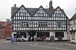 Bell Hotel |
| Berkeley Arms and Outbuilding | Tewkesbury | Hotel | C20 | 4 March 1952 | SO8926832631 51°59′31″N 2°09′28″W |
1201203 | 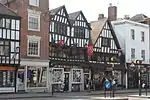 Berkeley Arms and Outbuilding |
| Black Bear Inn | Tewkesbury | Steps | Early 16th century | 4 March 1952 | SO8940733177 51°59′49″N 2°09′21″W |
1207382 | 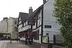 Black Bear Inn |
| Churchyard Gates | Abbey Precincts, Tewkesbury | Gate | 1750 | 4 March 1952 | SO8900832486 51°59′27″N 2°09′41″W |
1206025 | 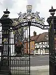 Churchyard Gates |
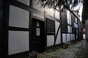
| Clarence House | Tewkesbury | Cruck House | Early 16th century | 4 March 1952 | SO8931032762 51°59′36″N 2°09′26″W |
1052276 | 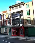 Clarence House |
| Craik House | Tewkesbury | Jettied House | LATE 15th century or early 16th century | 4 March 1952 | SO8915832589 51°59′30″N 2°09′34″W |
1205867 | 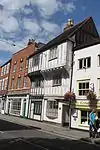 Craik House |
| Cross House | Tewkesbury | Apartment | 1994 | 4 March 1952 | SO8926432698 51°59′33″N 2°09′28″W |
1201228 | .jpg.webp) Cross House |
| Golden Key House | Tewkesbury | Jettied House | 16th century | 4 March 1952 | SO8927532760 51°59′35″N 2°09′27″W |
1206326 | 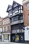 Golden Key House |
| Jessop House Hotel | Tewkesbury | Row House | Early 18th century | 4 March 1952 | SO8904732543 51°59′28″N 2°09′39″W |
1205712 | .jpg.webp) Jessop House Hotel |
| King John's Bridge | Tewkesbury | Steps | c. 1190 | 4 March 1952 | SO8937133231 51°59′51″N 2°09′22″W |
1201287 | 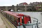 King John's Bridge |
| King John's Castle | The Mythe, Tewkesbury | House | Mid 16th century | 4 March 1952 | SO8890634119 52°00′19″N 2°09′47″W |
1201162 | 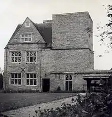 King John's Castle |
| Malthouse to rear of No 23, Barton Street | Tewkesbury | Malt House | 17th century | 4 March 1952 | SO8941532738 51°59′35″N 2°09′20″W |
1281018 | |
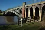
| Mythe Bridge | The Mythe, Tewkesbury | Road Bridge | 1825 | 4 March 1952 | SO8887333737 52°00′07″N 2°09′49″W |
1282810 | |
| Newton House | Tewkesbury | Open Hall House | late 14th century or 15th century | 4 March 1952 | SO8917532569 51°59′29″N 2°09′33″W |
1280642 | |
| Nottingham Arms | Tewkesbury | Jettied House | Early 16th century | 4 March 1952 | SO8931932823 51°59′38″N 2°09′25″W |
1201269 | 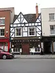 Nottingham Arms |
| Old Baptist Chapel | Tewkesbury | House | 1720 | 4 March 1952 | SO8902832562 51°59′29″N 2°09′40″W |
1207425 | |
| Royal Hop Pole Hotel | Tewkesbury | Jettied House | Late 15th century | 4 March 1952 | SO8920532630 51°59′31″N 2°09′31″W |
1205936 | 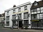 Royal Hop Pole Hotel |
| Tewkesbury Museum and attached Railings | Tewkesbury | Jettied House | early to mid 17th century | 4 March 1952 | SO8943432702 51°59′34″N 2°09′19″W |
1204935 | 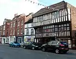 Tewkesbury Museum and attached Railings |
| 12 High Street (The Old Fleece) | Tewkesbury | Jettied House | Early 17th century | 4 March 1952 | SO8929032798 51°59′37″N 2°09′27″W |
1201243 | 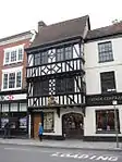 12 High Street (The Old Fleece) |
| Town Hall | Tewkesbury | Town Hall | 1788 | 4 March 1952 | SO8929232835 51°59′38″N 2°09′27″W |
1206399 | 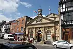 Town Hall |
| Tudor Hotel | Tewkesbury | House | Early 17th century | 4 March 1952 | SO8936533048 51°59′45″N 2°09′23″W |
1280099 | 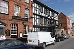 Tudor Hotel |
| Young Mens Christian Association | Tewkesbury | Row House | 17th century or earlier | 4 March 1952 | SO8922032641 51°59′32″N 2°09′30″W |
1201226 | 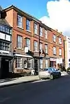 Young Mens Christian Association |
| No 9, Church Street including Yard Wall | Tewkesbury | Jettied House | 14th century or early 15th century | 4 March 1952 | SO8925632635 51°59′31″N 2°09′28″W |
1280735 | 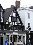 No 9, Church Street including Yard Wall |
| 10, Church Street | Tewkesbury | House | mid/late 18th century | 4 March 1952 | SO8925332631 51°59′31″N 2°09′29″W |
1282789 | |
| 15 and 16, Church Street | Tewkesbury | Jettied House | Late 15th century | 4 March 1952 | SO8922932613 51°59′31″N 2°09′30″W |
1280681 | 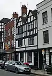 15 and 16, Church Street |
| No 77, Church St including Gate Piers | Tewkesbury | Row House | Early 18th century | 4 March 1952 | SO8913532573 51°59′29″N 2°09′35″W |
1280534 | |
| 88 and 88a, Church Street | Tewkesbury | House | 16th century | 4 March 1952 | SO8917732603 51°59′30″N 2°09′33″W |
1205905 | |
| 89 and 90, Church Street | Tewkesbury | Jettied House | 15th century or early 16th century | 4 March 1952 | SO8918032606 51°59′30″N 2°09′32″W |
1201225 | 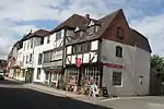 89 and 90, Church Street |
| 91 and 92, Church Street | Tewkesbury | Jettied House | 1564 | 4 March 1952 | SO8919232615 51°59′31″N 2°09′32″W |
1205919 | 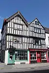 91 and 92, Church Street |
| 100 Church Street | Tewkesbury | Jettied House | 1664 | 4 March 1952 | SO8924032661 51°59′32″N 2°09′29″W |
1280450 | 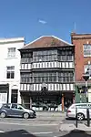 100 Church Street |
| 1, High Street | Tewkesbury | Row House | Early 18th century | 4 March 1952 | SO8926632710 51°59′34″N 2°09′28″W |
1201239 | |
| 2, High Street | Tewkesbury | Row House | Early 18th century | 4 March 1952 | SO8926532720 51°59′34″N 2°09′28″W |
1280304 | |
| 15, High Street | Tewkesbury | House | Late 16th century | 4 March 1952 | SO8929232812 51°59′37″N 2°09′27″W |
1206372 | 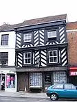 15, High Street |
| 39 and 40 High Street | Tewkesbury | Row House | c. 1730 | 4 March 1952 | SO8933332961 51°59′42″N 2°09′24″W |
1282770 | .jpg.webp) 39 and 40 High Street |
| 132, High Street | Tewkesbury | Jettied House | Early 16th century | 4 March 1952 | SO8932032803 51°59′37″N 2°09′25″W |
1282779 | 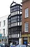 132, High Street |
| 135 High Street | Tewkesbury | Jettied House | 16th century | 4 March 1952 | SO8930932789 51°59′36″N 2°09′26″W |
1372300 | 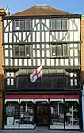 135 High Street |
| 137 High Street | Tewkesbury | Row House | 15th century | 4 March 1952 | SO8930732780 51°59′36″N 2°09′26″W |
1052263 | |
| 154, High Street | Tewkesbury | Jettied House | Late 15th century | 4 March 1952 | SO8928632702 51°59′34″N 2°09′27″W |
1201274 | .jpg.webp) 154, High Street |
| 155, High Street | Tewkesbury | Jettied House | late 15th century or early 16th century | 4 March 1952 | SO8928532698 51°59′33″N 2°09′27″W |
1282742 | 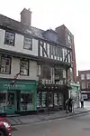 155, High Street |
| 22 Barton Street | Tewkesbury | Jettied House | 16th century | 4 March 1952 | SO8940932718 51°59′34″N 2°09′20″W |
1204795 | |
| 81 and 82, Barton Street | Tewkesbury | Cruck House | 14th century | 4 March 1952 | SO8932932678 51°59′33″N 2°09′25″W |
1205058 | |
| 1 and 2, Mill Bank | Tewkesbury | Jettied House | late 15th century or early 16th century | 4 March 1952 | SO8894632556 51°59′29″N 2°09′45″W |
1201278 | 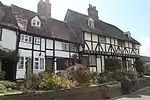 1 and 2, Mill Bank |
| Toddington House | Toddington | House | Early 17th century | 4 July 1960 | SP0345633079 51°59′46″N 1°57′04″W |
1303593 | .jpg.webp) Toddington House |
| Church of St Mary Magdalene | Twyning Village, Twyning | Anglican Church | 12th century | 4 July 1960 | SO8937336084 52°01′23″N 2°09′23″W |
1303825 | 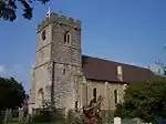 Church of St Mary Magdalene |
| Church of St Mary Magdalene | Elmstone Hardwicke, Uckington | Church | 12th century | 4 July 1960 | SO9203226065 51°55′59″N 2°07′02″W |
1340067 | 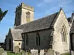 Church of St Mary Magdalene |
| Abbey Old House | Winchcombe | Abbey | Founded 972 | 4 July 1960 | SP0234028362 51°57′13″N 1°58′02″W |
1305465 | |
| Corndean Hall | Winchcombe | Villa | Early 19th century | 31 October 1984 | SP0160426192 51°56′03″N 1°58′41″W |
1171711 |  Corndean Hall |
| The Follies | Winchcombe | Row House | 17th century | 4 July 1960 | SP0266628524 51°57′19″N 1°57′45″W |
1172038 | |
| Tithe Barn 60 Metres South of Postlip Hall | Postlip, Winchcombe | Assembly Hall | 1960 | 4 July 1960 | SO9989326784 51°56′22″N 2°00′11″W |
1091478 | 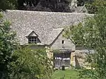 Tithe Barn 60 Metres South of Postlip Hall |
| Ye Old Corner Cupboard | Winchcombe | Inn (formerly farmhouse) | 16th century | 4 July 1960 | SP0203228138 51°57′06″N 1°58′19″W |
1091517 | 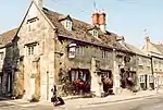 Ye Old Corner Cupboard |
| The Manor Farmhouse (two occupations) | Woodmancote | Farmhouse | C16-early 17th century | 4 July 1960 | SO9748227255 51°56′38″N 2°02′17″W |
1091637 | |

Notes
- The date given is the date used by Historic England as significant for the initial building or that of an important part in the structure's description.
- Sometimes known as OSGB36, the grid reference is based on the British national grid reference system used by the Ordnance Survey.
- The "List Entry Number" is a unique number assigned to each listed building and scheduled monument by Historic England.
External links
![]() Media related to Grade II* listed buildings in Gloucestershire at Wikimedia Commons
Media related to Grade II* listed buildings in Gloucestershire at Wikimedia Commons
This article is issued from Wikipedia. The text is licensed under Creative Commons - Attribution - Sharealike. Additional terms may apply for the media files.