Grade II* listed buildings in Thanet
There are over 20,000 Grade II* listed buildings in England. This page is a list of these buildings in the district of Thanet in Kent.
Thanet
| Name | Location | Type | Completed [note 1] | Date designated | Grid ref.[note 2] Geo-coordinates |
Entry number [note 3] | Image |
|---|---|---|---|---|---|---|---|
| 124 High Street | Ramsgate | House | Early 18th century | 4 February 1988 | TR3799165205 51°20′10″N 1°24′55″E |
1336660 | 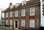 124 High Street |
| Church of All Saints | Birchington-on-Sea, Birchington, Thanet | Church | 12th century | 10 April 1951 | TR3019169034 51°22′25″N 1°18′22″E |
1094681 | 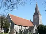 Church of All Saints |
| Barn about 50 Metres East of Ozengell Grange | Ramsgate | Tithe Barn | Late 14th century | 4 February 1988 | TR3572365638 51°20′27″N 1°22′59″E |
1336669 |  |
| Cemetery Chapels | Ramsgate | Anglican Church | 1872 | 4 February 1988 | TR3836866033 51°20′36″N 1°25′17″E |
1348349 | 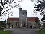 Cemetery Chapels |
| Chilton Farmhouse | Ramsgate | Farmhouse | 16th century foundations | 4 February 1988 | TR3633864593 51°19′53″N 1°23′29″E |
1085400 | |
| Cleve Court and Cleve Lodge | Monkton | House | 17th century or earlier | 11 October 1963 | TR3115666315 51°20′56″N 1°19′05″E |
1224683 | 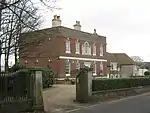 Cleve Court and Cleve Lodge |
| The Clock House | Royal Harbour, Ramsgate | House | 1817 | 4 February 1988 | TR3850764715 51°19′53″N 1°25′21″E |
1336325 | 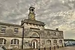 The Clock House |
| Conservatory and Wall to which it is attached | King George Vi Memorial Park, Ramsgate | Boundary Wall | Early 19th century | 15 February 1973 | TR3923766037 51°20′35″N 1°26′02″E |
1085336 | |
| Dent De Lion Gateway | Garlinge | Gateway | 15th century | 10 April 1951 | TR3321669627 51°22′40″N 1°20′59″E |
1341531 | _-_geograph.org.uk_-_331972.jpg.webp) Dent De Lion Gateway |
| Dreamland Cinema | Margate | Cinema | 1935 | 11 August 1992 | TR3501170630 51°23′10″N 1°22′34″E |
1260315 | 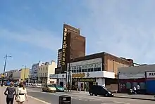 Dreamland Cinema |
| Gore Street Farmhouse | Monkton | Farmhouse | 16th century | 13 October 1952 | TR2730965117 51°20′23″N 1°15′44″E |
1224340 | |
| Harbour Cross Wall, Sluices, Bollards, Dry Dock, Basin Gates, Wing Wall and Dundee Steps | Royal Harbour, Ramsgate | Gate | 1821 | 30 October 1985 | TR3833264605 51°19′50″N 1°25′11″E |
1336324 |  Harbour Cross Wall, Sluices, Bollards, Dry Dock, Basin Gates, Wing Wall and Dundee Steps |
| India House | Margate | Villa | Built c1766-7 | 10 April 1951 | TR3543270926 51°23′19″N 1°22′57″E |
1351101 |  India House |
| John Sanger Memorial | Margate | Grave | 1889 or later | 16 January 2003 | TR3518869214 51°22′24″N 1°22′40″E |
1350382 | |
| Mausoleum of Sir Moses and Lady Judith Montefiore | Ramsgate | Mausoleum | 1862 | 13 August 1968 | TR3884165747 51°20′26″N 1°25′40″E |
1085375 | |
| Nether Hale Farmhouse | Nether Hale, St Nicholas at Wade | House | c. 1694 | 13 October 1982 | TR2793267790 51°21′48″N 1°16′22″E |
1266639 | |
| The Old House and Walled Forecourt | Ramsgate | House | Early 18th century | 4 February 1988 | TR3800465224 51°20′11″N 1°24′56″E |
1085392 | |
| Salmestone Grange including Chapel | Margate | House | 17th century | 10 April 1951 | TR3529469567 51°22′35″N 1°22′47″E |
1281452 | 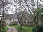 Salmestone Grange including Chapel |
| Saint Nicholas Court | St Nicholas at Wade | House | Early 18th century | 13 October 1952 | TR2595866890 51°21′22″N 1°14′38″E |
1224799 | |
| Parish Church of St Peter the Apostle | St Peter's, Broadstairs and St Peter's | Parish Church | Norman | 20 September 1974 | TR3808368451 51°21′55″N 1°25′08″E |
1273791 | 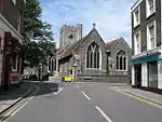 Parish Church of St Peter the Apostle |
| Scenic Railway at Dreamland | Margate | Fairground Ride | 1919-1920 | 1 March 2002 | TR3510870540 51°23′07″N 1°22′39″E |
1359602 | 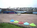 Scenic Railway at Dreamland |
| Stone House | Broadstairs, Thanet | House | 19th century | 24 January 1950 | TR3968269013 | 1267646 | |
| The Surf Boat Memorial, Margate Cemetery | Margate | Sculpture | 1900 | 11 July 2005 | TR3507069169 51°22′22″N 1°22′34″E |
1391529 | |
| Synagogue and adjacent Outbuilding | Ramsgate | Synagogue | 1831-1833 | 13 August 1968 | TR3883865734 51°20′26″N 1°25′40″E |
1051632 | 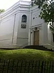 Synagogue and adjacent Outbuilding |
| Theatre Royal | Margate | Theatre | 1787 | 25 August 1955 | TR3558770766 51°23′13″N 1°23′05″E |
1341519 | 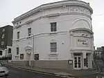 Theatre Royal |
| Townley House Mansion | Ramsgate | House | 1792 | 13 September 1974 | TR3799165337 51°20′14″N 1°24′56″E |
1336642 |  Townley House Mansion |
| Tudor House | Margate | House | modern restoration | 10 April 1951 | TR3554871055 51°23′23″N 1°23′03″E |
1351107 | 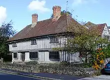 Tudor House |
| Wayborough Manor | Minster | Jettied House | c. 1460 | 11 October 1963 | TR3195465055 51°20′14″N 1°19′43″E |
1224593 | |
Notes
- The date given is the date used by Historic England as significant for the initial building or that of an important part in the structure's description.
- Sometimes known as OSGB36, the grid reference is based on the British national grid reference system used by the Ordnance Survey.
- The "List Entry Number" is a unique number assigned to each listed building and scheduled monument by Historic England.
External links
![]() Media related to Grade II* listed buildings in Kent at Wikimedia Commons
Media related to Grade II* listed buildings in Kent at Wikimedia Commons
This article is issued from Wikipedia. The text is licensed under Creative Commons - Attribution - Sharealike. Additional terms may apply for the media files.