Grade II* listed buildings in West Devon
There are over 20,000 Grade II* listed buildings in England. This page is a list of these buildings in the district of West Devon in Devon.
West Devon
| Name | Location | Type | Completed [note 1] | Date designated | Grid ref.[note 2] Geo-coordinates |
Entry number [note 3] | Image |
|---|---|---|---|---|---|---|---|
| Church of St Mary the Virgin | Belstone, West Devon | Parish Church | 15th century | 22 February 1967 | SX6192793500 50°43′29″N 3°57′27″W |
1106119 | 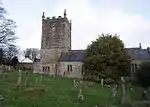 Church of St Mary the Virgin |
| Bere Barton | Bere Ferrers, West Devon | Dairy | 19th century | 21 March 1967 | SX4588163400 50°27′01″N 4°10′20″W |
1326389 |  |
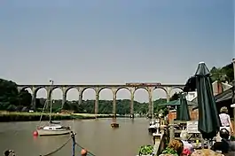
| Calstock Viaduct | Bere Ferrers, West Devon | Railway Lift | 1934 | 26 January 1987 | SX4335268637 50°29′48″N 4°12′36″W |
1105516 | |
| Bondleigh Barton | Bondleigh, West Devon | Farmhouse | Circa early 16th century | 8 October 1987 | SS6512404803 50°49′37″N 3°54′59″W |
1326421 | |
| Bradstone Manor House | Bradstone, West Devon | Cross Passage House | possibly late 16th century | 14 June 1952 | SX3818380908 50°36′19″N 4°17′17″W |
1326685 | |
| Chimsworthy | Bratton Clovelly, West Devon | Farmhouse | Late C16/Early 17th century | 22 February 1967 | SX4643193885 50°43′27″N 4°10′37″W |
1105620 | |
| North Breazle Farmhouse | Bratton Clovelly, West Devon | Farmhouse | c. 1500 | 7 September 1987 | SX4489892115 50°42′29″N 4°11′53″W |
1105624 | |
| West Burrow Farmhouse | Bratton Clovelly, West Devon | Farmhouse | C20 | 7 September 1987 | SX4908991718 50°42′20″N 4°08′19″W |
1164785 | |
| Wrixhill Farmhouse | Wrixhill, Bratton Clovelly, West Devon | Farmhouse | Late 15th century | 7 September 1987 | SX4642890670 50°41′43″N 4°10′33″W |
1105626 | |
| East Liddaton Farmhouse | Brentor, West Devon | Farmhouse | 15th century or earlier | 7 November 1985 | SX4627982638 50°37′23″N 4°10′28″W |
1163101 | |
| Church of St Bridget | Bridestowe, West Devon | Parish Church | Pre 15th century | 22 February 1967 | SX5135389430 50°41′08″N 4°06′20″W |
1326297 | 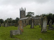 Church of St Bridget |
| Fernworthy | Fernworthy, Bridestowe, West Devon | Farmhouse | 15th century | 7 September 1987 | SX5116187047 50°39′50″N 4°06′26″W |
1317490 | |
| Great Bidlake | Bridestowe, West Devon | Manor House | Pre 16th century | 20 February 1952 | SX4946988652 50°40′41″N 4°07′55″W |
1326276 | 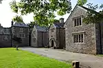 Great Bidlake |
| Berrator Farmhouse | Buckland Monachorum, West Devon | Farmhouse | 15th century | 21 March 1967 | SX4773068732 50°29′55″N 4°08′54″W |
1105485 | |
| Crapstone Barton, including Garden Wall and Gate Piers Immediately to West of House | Buckland Monachorum, West Devon | Farmhouse | 16th century | 21 March 1967 | SX4908867966 50°29′31″N 4°07′44″W |
1105460 | |
| Cuxton Farmhouse | Buckland Monachorum, West Devon | Farmhouse | late C16/early 17th century | 21 March 1967 | SX4874168261 50°29′40″N 4°08′02″W |
1326378 | |
| The Infirmary, Buckland Abbey | Buckland Monachorum, West Devon | Guest House | later 15th century | 26 January 1987 | SX4881866789 50°28′53″N 4°07′56″W |
1318245 | |
| Tower and adjoining Outbuilding Approx. 40 Metres to North of Buckland Abbey | Buckland Monachorum, West Devon | House | Mid C20 | 26 January 1987 | SX4872366825 50°28′54″N 4°08′01″W |
1105454 | |
| Uphill | Buckland Monachorum, West Devon | Farmhouse | 16th century | 21 March 1967 | SX5021465962 50°28′27″N 4°06′44″W |
1105490 | |
| Bishops House | Chagford, West Devon | House | Early 16th century | 20 February 1952 | SX7010587717 50°40′28″N 3°50′23″W |
1147239 | |
| British Legion Hall | Chagford, West Devon | Church House | late C16-early 17th century | 20 February 1952 | SX7008687490 50°40′21″N 3°50′24″W |
1308676 | .jpg.webp) British Legion Hall |
| Higher Horselake Farmhouse | Chagford, West Devon | Farmhouse | 16th century | 22 February 1967 | SX7196686530 50°39′52″N 3°48′47″W |
1309061 | |
| Lower Jurston Farmhouse including Garden Walls to South | Chagford, West Devon | Farmhouse | Late 19th century | 22 February 1967 | SX6966984508 50°38′44″N 3°50′41″W |
1166337 | |
| Stinhall Cottage including Garage adjoining to East | Chagford, West Devon | Farmhouse | 16th century and 17th century | 20 February 1952 | SX7063385519 50°39′18″N 3°49′53″W |
1106200 | |
| The Old School House approx. 7 Metres North-west of Yeo Farmhouse | Chagford, West Devon | Kitchen | late C16-early 17th century | 23 December 1986 | SX6782786593 50°39′50″N 3°52′17″W |
1326036 | |
| Barn approx. 3 Metres North of Yeo Farmhouse | Chagford, West Devon | Hall House | late C15-early 16th century | 23 December 1986 | SX6785186579 50°39′50″N 3°52′16″W |
1106169 | |
| The Three Crowns Hotel | Chagford | Dower House | Late 16th century | 20 February 1952 | SX7006987499 50°40′21″N 3°50′24″W |
1106177 | |
| Westcott Cottage | Chagford, West Devon | House | Early 17th century | 16 September 1987 | SX7101187637 50°40′27″N 3°49′37″W |
1308806 | |
| Whiddon Park Deer Park Wall between SX 723 889 and SX 722 894 | Chagford, West Devon | Gate | Medieval | 16 September 1987 | SX7230088900 50°41′09″N 3°48′33″W |
1146823 | |
| Whiddonpark House | Chagford, West Devon | House | c. 1980 | 20 February 1952 | SX7210389243 50°41′19″N 3°48′43″W |
1308809 | |
| Yellam | Chagford, West Devon | Farmhouse | Mid 17th century | 22 February 1967 | SX7144486999 50°40′06″N 3°49′14″W |
1106165 | |
| Parish Church of St Andrew | Coryton, West Devon | Church | 13th century | 21 March 1967 | SX4570583554 50°37′52″N 4°10′59″W |
1163271 | .jpg.webp) Parish Church of St Andrew |
| Church of St Michael | Princetown, Dartmoor Forest, West Devon | Church | c1810-1814 | 21 March 1967 | SX5868173714 50°32′46″N 3°59′45″W |
1105434 | |
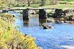
| Clapper Bridge | Postbridge, Dartmoor Forest, West Devon | Clapper Bridge | 13th century | 21 March 1967 | SX6482578900 50°35′39″N 3°54′40″W |
1105432 | |
| Lower Merripit Farmhouse | Dartmoor Forest, West Devon | Cruck House | 16th century | 6 March 1955 | SX6583079180 50°35′49″N 3°53′49″W |
1105416 | |
| Old Pizwell Farmhouse | Lydford, Dartmoor Forest, West Devon | Cruck House | Early 16th century | 28 October 1987 | SX6684278447 50°35′26″N 3°52′57″W |
1305883 | |
| Tor Royal | Dartmoor Forest, West Devon | House | 1785-1793 | 21 March 1967 | SX6003373141 50°32′28″N 3°58′36″W |
1305991 | |
| Church Cottage | Drewsteignton, West Devon | Cruck House | Mid 16th century | 22 February 1967 | SX7360690844 50°42′12″N 3°47′28″W |
1106076 | |
| Church Rooms | Drewsteignton, West Devon | Cruck House | Early-mid 16th century | 22 February 1967 | SX7363290819 50°42′12″N 3°47′27″W |
1106077 | |
| Coombe Farmhouse | Drewsteignton, West Devon | Farmhouse | Late C15-early 16th century | 4 March 1988 | SX7197689660 50°41′33″N 3°48′50″W |
1106090 | |
| Disused Farmhouse at Flood | Drewsteignton, West Devon | Farmhouse | Late C16-early 17th century | 4 March 1988 | SX7075393344 50°43′31″N 3°49′57″W |
1306655 | |
| Drascombe Barton | Drewsteignton, West Devon | Farmhouse | Mid 17th century | 22 February 1967 | SX7012792007 50°42′47″N 3°50′27″W |
1169119 | |
| Drewe Arms Public House | Drewsteignton, Drewsteignton, West Devon | House | C20 | 22 February 1967 | SX7359290861 50°42′13″N 3°47′29″W |
1306339 | 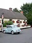 Drewe Arms Public House |
| Fingle Bridge | Fingle Bridge, Drewsteignton, West Devon | Road Bridge | 16th century | 22 February 1967 | SX7431089946 50°41′44″N 3°46′52″W |
1326071 | |
| Hobhouse Farmhouse | Drewsteignton, West Devon | Farmhouse | Early-mid 16th century | 4 March 1988 | SX6978992126 50°42′51″N 3°50′45″W |
1106095 | |
| Holly Cottage Lilac Cottage Pilgrim Cottage | Crockernwell, Drewsteignton, West Devon | Farmhouse | Mid-late 16th century | 4 March 1988 | SX7531592365 50°43′03″N 3°46′03″W |
1326097 | |
| Honeyford Farmhouse | Drewsteignton, West Devon | Farmhouse | 16th century | 4 March 1988 | SX7495791821 50°42′45″N 3°46′21″W |
1169271 | |
| Lambert Farmhouse | Drewsteignton, West Devon | Farmhouse | late 15th century early 16th century | 26 August 1965 | SX7506492842 50°43′18″N 3°46′17″W |
1105973 | |
| Middle Venton Farmhouse | Venton, Drewsteignton, West Devon | Farmhouse | Early or mid 16th century | 4 March 1988 | SX6949391065 50°42′16″N 3°50′58″W |
1106047 | |
| Nattonhole Farmhouse | Drewsteignton, West Devon | Farmhouse | Earlier origins | 4 April 1985 | SX7011491718 50°42′38″N 3°50′28″W |
1169301 | |
| Preston Farmhouse | Drewsteignton, West Devon | Farmhouse | Early-mid 17th century | 20 February 1952 | SX7497490379 50°41′58″N 3°46′18″W |
1169350 | |
| Stone Farmhouse | Drewsteignton, West Devon | Farmhouse | Early-mid 16th century | 4 March 1988 | SX7091090847 50°42′10″N 3°49′46″W |
1169409 | |
| Church of St Mary | Exbourne, West Devon | Parish Church | Early 14th century fabric | 22 February 1967 | SS6021601917 50°48′00″N 3°59′06″W |
1308851 | .jpg.webp) Church of St Mary |
| Church of St German | Germansweek, West Devon | Parish Church | 13th century | 22 February 1967 | SX4389694160 50°43′34″N 4°12′47″W |
1105609 | 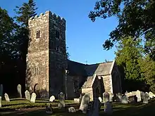 Church of St German |
| Ensworthy | Gidleigh, West Devon | Farmhouse | Later alterations | 16 September 1987 | SX6602289496 50°41′23″N 3°53′53″W |
1326028 | |
| North Forder Farmhouse | Forder, Gidleigh, West Devon | Farmhouse | late medieval | 16 September 1987 | SX6708589605 50°41′27″N 3°52′59″W |
1106127 | |
| West Chapple Farmhouse | Chapple, Gidleigh, West Devon | Farmhouse | later 16th century and early 17th century | 3 December 1976 | SX6710889084 50°41′10″N 3°52′57″W |
1326031 | |
| Deckport | Hatherleigh, West Devon | Farmhouse | Early to Mid 17th century | 22 February 1967 | SS5655603832 50°48′58″N 4°02′15″W |
1105269 | |
| 18 Market Street | Hatherleigh, West Devon | House | Earlier | 22 February 1967 | SS5418204535 50°49′19″N 4°04′18″W |
1326472 | |
| Church of Holy Cross | Highampton, West Devon | Parish Church | 12th century origins | 22 February 1967 | SS4895404614 50°49′17″N 4°08′45″W |
1165844 | .jpg.webp) Church of Holy Cross |
| Church of St John the Baptist | Horrabridge, West Devon | Parish Church | 1893 | 23 January 1987 | SX5123869670 50°30′28″N 4°05′58″W |
1305856 | 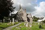 Church of St John the Baptist |
| Sortridge Manor | Horrabridge, West Devon | Cross Passage House | Mid 16th century | 14 June 1952 | SX5062571048 50°31′12″N 4°06′31″W |
1326223 | |
| Nos 1 and 2 Week Cottages including adjoining Linhay to North-west | Iddesleigh, West Devon | Farmhouse | circa early to mid 17th century | 29 February 1988 | SS5662206180 50°50′14″N 4°02′15″W |
1166057 | |
| Church of St Petrock | Inwardleigh, West Devon | Parish Church | Late 15th century | 22 February 1967 | SX5601099444 50°46′36″N 4°02′37″W |
1105205 |  Church of St Petrock |
| Broomford Manor including Service Yard immediately to North-west and Stable Yard immediately to North of that | Jacobstowe, West Devon | Country House | 1871-73 | 20 February 1952 | SS5775601749 50°47′52″N 4°01′11″W |
1105210 | |
| Church of St James | Jacobstowe, West Devon | Parish Church | 12th century origins | 22 February 1967 | SS5865001610 50°47′48″N 4°00′25″W |
1326489 | .jpg.webp) Church of St James |
| Croft Farmhouse including Farm Building Adjoining to North | Jacobstowe, West Devon | Farmhouse | late medieval | 28 May 1987 | SS5699800324 50°47′05″N 4°01′48″W |
1105211 | |
| Range of Farm Buildings Around Courtyard and Pump to East of Croft Farmhouse | Jacobstowe, West Devon | Trough | Late 19th century | 28 May 1987 | SS5701600315 50°47′05″N 4°01′47″W |
1146552 | |
| Stable Block about 10 Metres North East of Kelly House | Kelly, West Devon | Stable | 1740 | 14 June 1952 | SX3948881444 50°36′38″N 4°16′12″W |
1104813 | |
| Church of St Peter | Lamerton, West Devon | Parish Church | Late C14/Early 15th century | 21 March 1967 | SX4510577075 50°34′22″N 4°11′20″W |
1171163 | 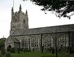 Church of St Peter |
| Longhouse at SX 466 780 | Lamerton, West Devon | Barn | 1987 | 23 January 1987 | SX4660078000 50°34′54″N 4°10′05″W |
1105776 | |
| Venn House | Lamerton, West Devon | House | 17th century | 21 March 1967 | SX4520076157 50°33′53″N 4°11′14″W |
1305736 | |
| Walls and Gateway attached to North of Collacombe Manor | Lamerton, West Devon | Gate | Late 16th century | 14 June 1952 | SX4309476480 50°34′01″N 4°13′01″W |
1170965 | |
| Dovecote about 10 Metres North West of the Manor Hotel | Lewtrenchard, West Devon | Dovecote | Late 19th century | 7 November 1985 | SX4585586095 50°39′15″N 4°10′55″W |
1105586 | |
| Table Tomb about 7 Metres South East of the Porch of the Church of St Peter | Lewtrenchard, West Devon | Table Tomb | 1623 | 7 November 1985 | SX4572186099 50°39′15″N 4°11′02″W |
1326327 | 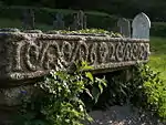 Table Tomb about 7 Metres South East of the Porch of the Church of St Peter |
| The Dower House | Lew Mill, Lewtrenchard, West Devon | House | 1664 | 7 November 1985 | SX4678886211 50°39′19″N 4°10′08″W |
1104818 | |
| The Manor Hotel | Lewtrenchard, West Devon | Manor House | between 1881 and circa 1910 | 14 May 1952 | SX4588086066 50°39′14″N 4°10′54″W |
1318032 | 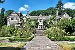 The Manor Hotel |
| Granary with Dovecot over about 30 Metres North West of Smallacombe Farmhouse | Lifton, West Devon | Dovecote | circa early 18th century | 7 November 1985 | SX3714886162 50°39′08″N 4°18′18″W |
1105590 | |
| Smallacombe Farmhouse | Lifton, West Devon | Farmhouse | circa late 16th century origins | 14 June 1952 | SX3719286161 50°39′08″N 4°18′16″W |
1317882 | |
| Wall Mounting Block and 2 Pairs of Gate Piers Round Garden to the East of Smallacombe Farmhouse | Lifton, West Devon | Gate Pier | circa early 18th century | 21 March 1967 | SX3722486142 50°39′08″N 4°18′14″W |
1164213 | |
| Church of St Petrock | Lydford, West Devon | Parish Church | 13th century | 21 March 1967 | SX5090884739 50°38′36″N 4°06′36″W |
1326399 | 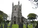 Church of St Petrock |
| Wringworthy Farmhouse | Mary Tavy, West Devon | Farmhouse | Early 16th century | 14 June 1952 | SX5002577246 50°34′32″N 4°07′10″W |
1326254 | |
| Coach House and Stables to the North West of Sydenham House | Sydenham, Marystow, West Devon | Apartment | circa mid 17th century | 21 March 1967 | SX4278983895 50°38′01″N 4°13′28″W |
1317598 | |
| Yew Tree Cottage | Dippertown, Marystow, West Devon | House | 16th century | 7 November 1985 | SX4286384654 50°38′25″N 4°13′25″W |
1164642 | |
| Meavy Barton | Meavy, West Devon | Farmhouse | Early 16th century | 26 January 1987 | SX5398667234 50°29′12″N 4°03′35″W |
1105445 | |
| Church of St Michael | Meeth, West Devon | Parish Church | Norman | 22 February 1967 | SS5480508283 50°51′21″N 4°03′51″W |
1308852 | 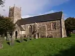 Church of St Michael |
| Woolladon Farmhouse | Meeth, West Devon | Farmhouse | 1666 | 29 February 1988 | SS5267107589 50°50′56″N 4°05′39″W |
1326490 | |
| Edgcumbe | Milton Abbot, West Devon | Farmhouse | 1967 | 21 March 1967 | SX3981679186 50°35′25″N 4°15′52″W |
1105539 | |
| Forda House | Milton Abbot, West Devon | Farmhouse | medieval origins | 7 November 1985 | SX4352182147 50°37′05″N 4°12′48″W |
1326342 | |
| Leigh Barton | Milton Abbot, West Devon | Farmhouse | Early 16th century | 21 March 1967 | SX3952777315 50°34′25″N 4°16′03″W |
1105543 | |
| Retaining Wall on the Terrace to the Terrace to the South East of Endsleigh House | Endsleigh, Milton Abbot, West Devon | Wall | c. 1810 | 7 November 1985 | SX3916178595 50°35′06″N 4°16′24″W |
1165098 | |
| Sundial in the Garden to the South of Endsleigh House | Endsleigh, Milton Abbot, West Devon | Sundial | circa early 19th century | 7 November 1985 | SX3910478578 50°35′05″N 4°16′27″W |
1105546 | |
| The Dairy Dell Cottage | Endsleigh, Milton Abbot, West Devon | House | c. 1814 | 7 November 1985 | SX3892978634 50°35′07″N 4°16′36″W |
1317408 | 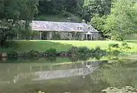 The Dairy Dell Cottage |
| East Lake Farmhouse | Monkokehampton, West Devon | Farmhouse | early to mid 17th century | 29 February 1988 | SS5884906121 50°50′14″N 4°00′21″W |
1105186 | |
| Cottles Barton | North Tawton, West Devon | House | 1952 | 20 February 1952 | SS6606500492 50°47′19″N 3°54′05″W |
1326410 | |
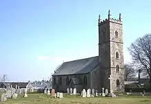
| Former Church of St Martin | North Tawton, West Devon | Church | Late 13th century | 22 February 1967 | SS7023400942 50°47′37″N 3°50′33″W |
1105369 | 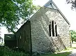 Former Church of St Martin |
| Greenslade Farmhouse | North Tawton, West Devon | Farmhouse | Probable medieval core | 22 February 1967 | SS6493700262 50°47′10″N 3°55′03″W |
1105370 | |
| Upcott Farmhouse | North Tawton, West Devon | Farmhouse | Circa late 15th century | 8 October 1987 | SS6998902610 50°48′30″N 3°50′48″W |
1326434 | |
| Well immediately to West of Westacott Barton | North Tawton, West Devon | Well Head | Probably 17th century | 8 October 1987 | SS6846602250 50°48′17″N 3°52′05″W |
1105337 | |
| Westacott Barton | North Tawton, West Devon | Farmhouse | Late 15th century or early 16th century | 22 February 1967 | SS6849002244 50°48′17″N 3°52′04″W |
1326435 | |
| Church of St Mary | Ashbury, Northlew, West Devon | Parish Church | Late C16/Early 17th century | 22 February 1967 | SX5078897959 50°45′43″N 4°07′01″W |
1326285 |  Church of St Mary |
| Chapel of St James | Okehampton, West Devon | Chapel | 15th century | 5 February 1952 | SX5884995214 50°44′22″N 4°00′06″W |
1105858 | 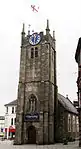 Chapel of St James |
| Oaklands | Okehampton, West Devon | Country House | c. 1820 | 5 February 1952 | SX5884695845 50°44′42″N 4°00′07″W |
1326189 | |
| Town Hall | Okehampton, West Devon | House | 1685 | 5 February 1952 | SX5873195200 50°44′21″N 4°00′12″W |
1105855 | 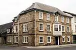 Town Hall |
| Church House | Sampford Courtenay, West Devon | Cruck House | Early 16th century | 8 October 1987 | SS6321001230 50°47′40″N 3°56′32″W |
1105293 | |
| Lower (or Great) Cliston | Sampford Courtenay, West Devon | Farmhouse | Early 16th century | 8 October 1987 | SS6181601844 50°47′59″N 3°57′44″W |
1105319 | |
| Slade Farmhouse | Honeychurch, Sampford Courtenay, West Devon | Farmhouse | Circa mid 15th century | 8 October 1987 | SS6279002865 50°48′33″N 3°56′56″W |
1326486 | |
| South Town | Sampford Courtenay, Sampford Courtenay, West Devon | Farmhouse | Mid 17th century | 8 October 1987 | SS6331000839 50°47′27″N 3°56′26″W |
1326452 | |
| Sampford Manor and Attached Barn and Front Wall | Sampford Spiney, Sampford Spiney, West Devon | Farmhouse | Early 16th century | 21 March 1967 | SX5330072469 50°32′01″N 4°04′17″W |
1105727 | 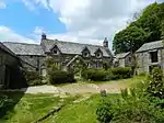 Sampford Manor and Attached Barn and Front Wall |
| Warne's Kitchen | Sampford Spiney, West Devon | Cow House | Early 16th century | 21 March 1967 | SX5363072795 50°32′12″N 4°04′01″W |
1105760 | |
| Whimington Farmhouse | Sampford Spiney, West Devon | Farmhouse | Early 16th century | 21 March 1967 | SX5233771457 50°31′27″N 4°05′04″W |
1171956 | |
| Yeo Old Farmhouse | Sheepstor, West Devon | Farmhouse | 1610 | 28 October 1987 | SX5511066951 50°29′04″N 4°02′37″W |
1105410 | |
| Church of St Thomas of Canterbury | Sourton, West Devon | Parish Church | 14th century | 22 February 1967 | SX5358790295 50°41′38″N 4°04′28″W |
1325962 | 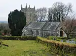 Church of St Thomas of Canterbury |
| Black Street House | South Tawton, West Devon | Farmhouse | Early-mid 16th century | 22 February 1967 | SX6558194485 50°44′04″N 3°54′22″W |
1106034 | |
| Bowling Green Pavilion approx. 100 Metres South of Wood House | South Tawton, West Devon | Bowling Green Pavilion | 1899-1905 | 4 March 1988 | SX6545495955 50°44′51″N 3°54′31″W |
1106028 | |
| Bridge approx. 130 Metres South East of Wood House | South Tawton, West Devon | Bridge | 1899-1905 | 4 March 1988 | SX6564795907 50°44′50″N 3°54′21″W |
1305935 | |
| Chapel of St Mary including Boundary Walls adjoining to North West | South Zeal, South Tawton, West Devon | Gate | 19th century | 22 February 1967 | SX6508093580 50°43′34″N 3°54′47″W |
1326105 | 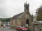 Chapel of St Mary including Boundary Walls adjoining to North West |
| Church House | South Tawton, West Devon | Cruck House | Late C15-early 16th century | 22 February 1967 | SX6528894447 50°44′02″N 3°54′37″W |
1106005 | 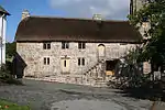 Church House |
| Front Garden Walls and Gateway adjoining East of West Week Farmhouse | South Tawton, West Devon | Gate | 1656 | 22 February 1967 | SX6570292606 50°43′03″N 3°54′14″W |
1306024 | |
| Gate Posts adjoining North West of Wood House Woodsheds | South Tawton, West Devon | Gate | 1899-1905 | 4 March 1988 | SX6547396029 50°44′54″N 3°54′30″W |
1106025 | |
| Gate Posts and Gate approx. 140 Metres South East of Wood House | South Tawton, West Devon | Gate | 1899-1905 | 4 March 1988 | SX6573095886 50°44′49″N 3°54′16″W |
1106029 | |
| Hendicott Farmhouse | South Tawton, West Devon | Farmhouse | Late C15-early 16th century | 4 March 1988 | SX6834698640 50°46′20″N 3°52′07″W |
1170257 | |
| Lower Sessland Farmhouse including Cob Walls adjoining to North West and South West | South Tawton, West Devon | Farmhouse | Early 16th century | 22 February 1967 | SX6783497549 50°45′45″N 3°52′31″W |
1170877 | |
| Mill House | South Zeal, South Tawton, West Devon | House | Late 19th century | 4 March 1988 | SX6514093533 50°43′33″N 3°54′43″W |
1326106 | |
| Moorside | South Zeal, South Tawton, West Devon | House | Early-mid 17th century | 4 March 1988 | SX6512893537 50°43′33″N 3°54′44″W |
1305676 | |
| Powlesland Farmhouse | South Tawton, West Devon | Farmhouse | Mid 16th century | 4 March 1988 | SX6886296016 50°44′56″N 3°51′37″W |
1106059 | |
| Steps and Terrace Walls around Tennis Lawn South West of Wood House | South Tawton, West Devon | Wall | 1899-1905 | 4 March 1988 | SX6545096020 50°44′53″N 3°54′31″W |
1106027 | |
| Summerhouse approx. 120 Metres South West of Wood House | South Tawton, West Devon | Gate | 1899-1905 | 4 March 1988 | SX6533895949 50°44′51″N 3°54′36″W |
1326114 | |
| Summerhouse approx. 250 Metres South East of Wood House | South Tawton, West Devon | Summerhouse | 1899-1905 | 4 March 1988 | SX6567295791 50°44′46″N 3°54′19″W |
1106030 | |
| Sundial approx. 110 Metres South of Wood House | South Tawton, West Devon | Sundial | 1899-1905 | 4 March 1988 | SX6545995912 50°44′50″N 3°54′30″W |
1170704 | |
| Terrace Walls, Gazebos, Steps, Pond and Statue adjoining South-east of Wood House | South Tawton, West Devon | Gate | 1899-1905 | 4 March 1988 | SX6553695968 50°44′52″N 3°54′26″W |
1106024 | |
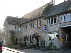
| The Oxenham Arms | South Zeal, South Tawton, West Devon | Courtyard House | Late C16-early 17th century or earlier | 20 February 1952 | SX6510293539 50°43′33″N 3°54′45″W |
1305729 | 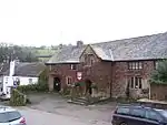 The Oxenham Arms |
| Village Cross | South Zeal, South Tawton, West Devon | Village Cross | 15th century | 22 February 1967 | SX6505793594 50°43′35″N 3°54′48″W |
1106010 | 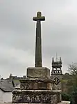 Village Cross |
| Walls and Summerhouse of Wood House North Garden | South Tawton, West Devon | Gate | 1899-1905 | 4 March 1988 | SX6546096041 50°44′54″N 3°54′30″W |
1170691 | |
| Well Farmhouse | South Tawton, West Devon | Farmhouse | Mid or late 16th century or later | 22 February 1967 | SX6843190771 50°42′06″N 3°51′52″W |
1170518 | |
| West Week Farmhouse | South Tawton, West Devon | Farmhouse | Early 16th century | 20 February 1952 | SX6566692598 50°43′03″N 3°54′15″W |
1106061 | |
| Wickington Farmhouse | South Tawton, West Devon | Farmhouse | 15th century | 20 February 1952 | SX6569296705 50°45′16″N 3°54′19″W |
1106017 | |
| Wood House | South Tawton, West Devon | House | 1899-1905 | 28 January 1987 | SX6548496031 50°44′54″N 3°54′29″W |
1106023 | |
| Combe Farmhouse | Spreyton, West Devon | Farmhouse | Early-mid 17th century | 4 March 1988 | SX6944997902 50°45′58″N 3°51′09″W |
1171794 | |
| The Barton including Service Rooms adjoining to the North | Spreyton, West Devon | Farmhouse | 16th century | 22 February 1967 | SX6971196740 50°45′20″N 3°50′54″W |
1171977 | |
| Finch Foundry & Foundry House | Sticklepath, West Devon | Foundry and House | Possibly late 18th century | 8 October 1987 | SX6418794084 50°43′50″N 3°55′33″W |
1105302 | 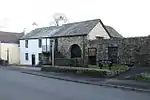 Finch Foundry & Foundry House |
| Hayne | Stowford, West Devon | House | c. 1810 | 14 June 1952 | SX4219086680 50°39′30″N 4°14′03″W |
1326336 | |
| Stone in Churchyard about 3 Metres North of the East Churchyard Gate | Stowford, West Devon | Inscribed Stone | probably C7 | 7 November 1985 | SX4328687005 50°39′42″N 4°13′07″W |
1105497 | |
| Church of St Mary | Sydenham Damerel, West Devon | Parish Church | 15th century | 7 November 1985 | SX4094176002 50°33′43″N 4°14′50″W |
1165836 | 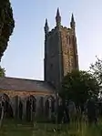 Church of St Mary |
| Church of Our Lady and St Mary Magdalene | Tavistock, West Devon | Roman Catholic Church | 1865 | 7 September 1951 | SX4746873929 50°32′43″N 4°09′15″W |
1105836 | 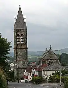 Church of Our Lady and St Mary Magdalene |
| Guildhall, Police Station, attached Railings and Boundary Walls | Tavistock, West Devon | Guildhall | 1848 | 7 September 1951 | SX4822474409 50°32′59″N 4°08′37″W |
1309358 | |
| Range of Farm Buildings in planned Farmyard including Threshing Barn with Waterwheel and Granary and Cow House with Dung Pit, etc | Tavistock, West Devon | House | 1851 | 23 January 1987 | SX4826676994 50°34′23″N 4°08′39″W |
1172309 | |
| Barn, Calf House and Linhay approx. 2 Metres South of Higher Shilstone Farmhouse | Throwleigh, West Devon | Barn | 17th century | 20 July 1974 | SX6602990123 50°41′43″N 3°53′54″W |
1106135 | |
| Chagford Bridge | Throwleigh, West Devon | Road Bridge | 16th century or 17th century | 22 February 1967 | SX6936787952 50°40′35″N 3°51′01″W |
1106212 | 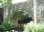 Chagford Bridge |
| Church House | Throwleigh, West Devon | House | late C16-early 17th century | 22 February 1967 | SX6679890780 50°42′05″N 3°53′15″W |
1168267 | |
| Clannaborough Farmhouse including Garden Walls | Throwleigh, West Devon | Farmhouse | Late 19th century | 22 February 1967 | SX6612591209 50°42′18″N 3°53′50″W |
1106134 | |
| Throwleigh Barton | Throwleigh, West Devon | House | late 16th century and 17th century | 16 June 1987 | SX6688890784 50°42′05″N 3°53′11″W |
1326043 | |
| Waye Cottage including Garden Boundary Walls to South | Throwleigh, West Devon | Farmhouse | late 16th century - early 17th century | 22 February 1967 | SX6891289927 50°41′39″N 3°51′26″W |
1168105 | |
| Wonson Manor | Wonson, Throwleigh, West Devon | Manor House | 17th century or 18th century | 22 February 1967 | SX6745689693 50°41′30″N 3°52′40″W |
1326044 | |
| Church House Cottages | Walkhampton, West Devon | House | 1987 | 14 June 1952 | SX5371070177 50°30′47″N 4°03′53″W |
1105374 |  Church House Cottages |
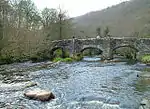
| Huckworthy Bridge | Walkhampton, West Devon | Bridge | Late 15th century or Early 16th century | 14 June 1952 | SX5314370533 50°30′58″N 4°04′22″W |
1171550 | 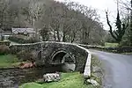 Huckworthy Bridge |
| Welltown Farmhouse | Walkhampton, West Devon | Farmhouse | c. 1500 | 14 June 1952 | SX5410170050 50°30′43″N 4°03′33″W |
1171620 | |
| Barn attached to North West of Walreddon Manor | Whitchurch, West Devon | Threshing Barn | Early 17th century | 21 March 1967 | SX4773471328 50°31′19″N 4°08′58″W |
1326274 | |
| Stable and attached Cart Shed about 5m South East of Walreddon Manor | Whitchurch, West Devon | Cart Shed | Late C18/Early 19th century | 21 March 1967 | SX4777371295 50°31′18″N 4°08′56″W |
1105715 | |
| Wall with Gateway and attached Cottage attached to South West of Walreddon Manor | Whitchurch, West Devon | House | C20 | 23 January 1987 | SX4774271293 50°31′18″N 4°08′57″W |
1152118 | |
| Walls and Pair of Gate-piers attached to North East of Walreddon Manor | Whitchurch, West Devon | Gate Pier | Probably Early 17th century | 21 March 1967 | SX4778971323 50°31′19″N 4°08′55″W |
1304908 | |
Notes
- The date given is the date used by Historic England as significant for the initial building or that of an important part in the structure's description.
- Sometimes known as OSGB36, the grid reference is based on the British national grid reference system used by the Ordnance Survey.
- The "List Entry Number" is a unique number assigned to each listed building and scheduled monument by Historic England.
External links
![]() Media related to Grade II* listed buildings in Devon at Wikimedia Commons
Media related to Grade II* listed buildings in Devon at Wikimedia Commons
This article is issued from Wikipedia. The text is licensed under Creative Commons - Attribution - Sharealike. Additional terms may apply for the media files.