National Register of Historic Places listings in Cherokee County, Kansas
This is a list of the National Register of Historic Places listings in Cherokee County, Kansas.

Location of Cherokee County in Kansas
This is intended to be a complete list of the properties and districts on the National Register of Historic Places in Cherokee County, Kansas, United States. The locations of National Register properties and districts for which the latitude and longitude coordinates are included below, may be seen in a map.[1]
There are 12 properties and districts listed on the National Register in the county.
- This National Park Service list is complete through NPS recent listings posted February 5, 2021.[2]
Current listings
| [3] | Name on the Register[4] | Image | Date listed[5] | Location | City or town | Description |
|---|---|---|---|---|---|---|
| 1 | Baxter Springs High School | August 8, 2014 (#14000479) |
1520 Cleveland Ave. 37°01′12″N 94°43′58″W |
Baxter Springs | Now the middle school? | |
| 2 | Baxter Springs Independent Oil and Gas Service Station | 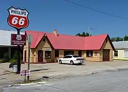 Baxter Springs Independent Oil and Gas Service Station |
August 29, 2003 (#03000841) |
940 Military Ave. 37°01′33″N 94°44′05″W |
Baxter Springs | |
| 3 | Big Brutus | 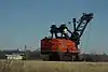 Big Brutus |
January 5, 2018 (#100001945) |
6509 NW 60th St. 37°16′26″N 94°56′20″W |
West Mineral | A very large electric shovel. |
| 4 | Brush Creek Bridge | 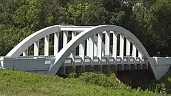 Brush Creek Bridge |
March 10, 1983 (#83000419) |
North of Baxter Springs 37°04′24″N 94°44′26″W |
Baxter Springs | Only surviving Marsh arch bridge on the entire length of the former U.S. Route 66 highway (this section is now a county highway) |
| 5 | Columbus Public Carnegie Library | June 25, 1987 (#87000932) |
205 N. Kansas 37°10′22″N 94°50′36″W |
Columbus | ||
| 6 | Johnston Library | 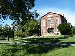 Johnston Library |
November 21, 1976 (#76000817) |
210 W. 10th St. 37°01′35″N 94°44′12″W |
Baxter Springs | |
| 7 | Kansas Route 66 Historic District-East Galena | 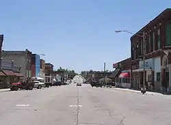 Kansas Route 66 Historic District-East Galena |
August 29, 2003 (#03000842) |
U.S. Route 66 37°05′05″N 94°37′43″W |
Galena | Includes part of U.S. Route 66 in Kansas |
| 8 | Kansas Route 66 Historic District-North Baxter Springs | April 14, 2015 (#15000141) |
N. Willow Ave., SE. 50th St.; also SE. Beasley Rd. 37°02′14″N 94°44′26″W |
Baxter Springs | Second set of addresses represent a boundary increase listed January 11, 2017 | |
| 9 | Rial A. Niles House | 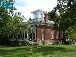 Rial A. Niles House |
September 6, 2006 (#06000772) |
605 E. 12th St. 37°01′24″N 94°43′43″W |
Baxter Springs | |
| 10 | Edgar Backus Schermerhorn House | 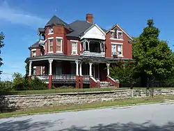 Edgar Backus Schermerhorn House |
August 21, 1989 (#89001146) |
803 E. 5th St. 37°04′35″N 94°37′53″W |
Galena | |
| 11 | Soffietti-Boccia Grocery Store | March 27, 2017 (#100000793) |
313 Fleming St. 37°17′03″N 94°55′45″W |
West Mineral | ||
| 12 | Williams' Store | 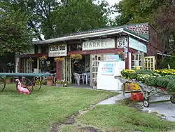 Williams' Store |
August 29, 2003 (#03000843) |
7109 SE U.S. Route 66 37°04′30″N 94°42′10″W |
Riverton | Now known as Eisler Brothers Old Riverton Store. |
See also
| Wikimedia Commons has media related to National Register of Historic Places in Cherokee County, Kansas. |
References
- The latitude and longitude information provided in this table was derived originally from the National Register Information System, which has been found to be fairly accurate for about 99% of listings. Some locations in this table may have been corrected to current GPS standards.
- "National Register of Historic Places: Weekly List Actions". National Park Service, United States Department of the Interior. Retrieved on February 5, 2021.
- Numbers represent an alphabetical ordering by significant words. Various colorings, defined here, differentiate National Historic Landmarks and historic districts from other NRHP buildings, structures, sites or objects.
- "National Register Information System". National Register of Historic Places. National Park Service. March 13, 2009.
- The eight-digit number below each date is the number assigned to each location in the National Register Information System database, which can be viewed by clicking the number.

Municipalities and communities of Cherokee County, Kansas, United States | ||
|---|---|---|
| Cities | Map of Kansas highlighting Cherokee County | |
| Unincorporated communities | ||
| Ghost towns | ||
| Townships | ||
| Footnotes | †This populated place is designated a Census-Designated Place (CDP) by the United States Census Bureau, ‡This populated place also has portions in an adjacent county or counties. | |
| ||
This article is issued from Wikipedia. The text is licensed under Creative Commons - Attribution - Sharealike. Additional terms may apply for the media files.