National Register of Historic Places listings in Pratt County, Kansas
This is a list of the National Register of Historic Places listings in Pratt County, Kansas. It is intended to be a complete list of the properties and districts on the National Register of Historic Places in Pratt County, Kansas, United States. The locations of National Register properties and districts for which the latitude and longitude coordinates are included below, may be seen in an online map.
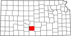
Location of Pratt County in Kansas
There are 9 properties and districts listed on the National Register in the county.
- This National Park Service list is complete through NPS recent listings posted February 5, 2021.[1]
Current listings
| [2] | Name on the Register[3] | Image | Date listed[4] | Location | City or town | Description |
|---|---|---|---|---|---|---|
| 1 | Earl H. Ellis VFW Post No. 1362 | 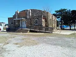 Earl H. Ellis VFW Post No. 1362 |
July 12, 2006 (#06000597) |
701 E. 1st St. 37°38′45″N 98°43′53″W |
Pratt | Art Deco-style Veterans of Foreign Wars post built in 1939. |
| 2 | S.P. Gebhart House | February 12, 1987 (#87000074) |
105 N. Iuka St. 37°38′47″N 98°44′30″W |
Pratt | ||
| 3 | Hotel Roberts | 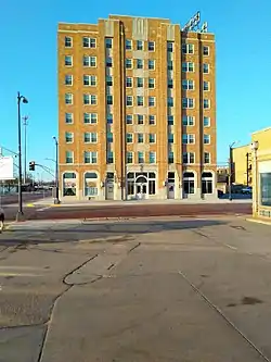 Hotel Roberts |
January 7, 2015 (#14001122) |
120 W. 4th St. 37°38′34″N 98°44′24″W |
Pratt | |
| 4 | Norden Bombsight Storage Vaults | September 25, 2012 (#12000816) |
305 Flint Rd. 37°42′14″N 98°44′33″W |
Pratt | part of the World War II-Era Aviation-Related Facilities of Kansas MPS | |
| 5 | Parachute Building | April 22, 2009 (#09000231) |
40131 Barker Ave. 37°42′15″N 98°44′27″W |
Pratt | ||
| 6 | Pratt Archeological Site | April 13, 1972 (#72000522) |
Address restricted |
Pratt | ||
| 7 | J.R. Rice Barn and Granary | June 9, 1995 (#95000695) |
North of U.S. Route 54, northwest of Cullison 37°38′17″N 98°56′32″W |
Cullison | ||
| 8 | J.R. Rice Farmstead | January 7, 2000 (#99001649) |
NE4, SE4, SE4, NE4, 3-28-15 37°38′20″N 98°56′31″W |
Cullison | ||
| 9 | Thornton Adobe Barn | December 10, 2003 (#03001258) |
1 mile (1.6 km) east and 1.25 miles (2.01 km) north of Isabel 37°29′16″N 98°32′15″W |
Isabel | Modest dairy barn built from adobe and reused corrugated metal in 1942, under materials shortages of World War II. |
See also
References
- "National Register of Historic Places: Weekly List Actions". National Park Service, United States Department of the Interior. Retrieved on February 5, 2021.
- Numbers represent an alphabetical ordering by significant words. Various colorings, defined here, differentiate National Historic Landmarks and historic districts from other NRHP buildings, structures, sites or objects.
- "National Register Information System". National Register of Historic Places. National Park Service. July 9, 2010.
- The eight-digit number below each date is the number assigned to each location in the National Register Information System database, which can be viewed by clicking the number.
External links
| Wikimedia Commons has media related to National Register of Historic Places in Pratt County, Kansas. |

| Topics | |
|---|---|
| Lists by state |
|
| Lists by insular areas | |
| Lists by associated state | |
| Other areas | |
| Related | |
| |
This article is issued from Wikipedia. The text is licensed under Creative Commons - Attribution - Sharealike. Additional terms may apply for the media files.