National Register of Historic Places listings in Reno County, Kansas
This is a list of the National Register of Historic Places listings in Reno County, Kansas.
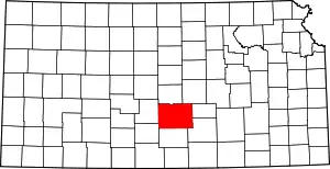
Location of Reno County in Kansas
This is intended to be a complete list of the properties and districts on the National Register of Historic Places in Reno County, Kansas, United States. The locations of National Register properties and districts for which the latitude and longitude coordinates are included below, may be seen in a map.[1]
There are 19 properties and districts listed on the National Register in the county, and two former listings.
- This National Park Service list is complete through NPS recent listings posted January 29, 2021.[2]
Current listings
| [3] | Name on the Register[4] | Image | Date listed[5] | Location | City or town | Description |
|---|---|---|---|---|---|---|
| 1 | Downtown Core North Historic District |  Downtown Core North Historic District |
November 18, 2004 (#04000739) |
Generally bounded by BNSF Railway tracks, 1st Ave., west side of N. Main and Poplar St. 38°03′22″N 97°55′50″W |
Hutchinson | Commercial and Industrial Resources of Hutchinson MPS |
| 2 | Downtown Core South Historic District | 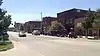 Downtown Core South Historic District |
November 18, 2004 (#04000737) |
Generally bounded by C Ave., the alley south of Sherman, and Washington and Poplar Sts. 38°03′07″N 97°55′52″W |
Hutchinson | Commercial and Industrial Resources of Hutchinson MPS |
| 3 | Fox Theater | 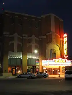 Fox Theater |
September 7, 1989 (#89001391) |
18 E. First 38°03′16″N 97°55′48″W |
Hutchinson | |
| 4 | John P.O. Graber House | 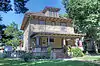 John P.O. Graber House |
January 27, 1994 (#93001518) |
208 E. 6th St. 38°04′53″N 97°55′37″W |
Hutchinson | |
| 5 | Hamlin Block | 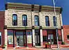 Hamlin Block |
July 2, 2008 (#08000613) |
304-306 S. Main St. 38°02′54″N 97°55′55″W |
Hutchinson | Commercial and Industrial Resources of Hutchinson MPS |
| 6 | Hoke Building | 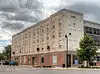 Hoke Building |
August 4, 2011 (#11000506) |
25 E. 1st Ave. 38°03′11″N 97°55′49″W |
Hutchinson | Commercial and Industrial Resources of Hutchinson MPS |
| 7 | Houston Whiteside Historic District | November 26, 2004 (#04000738) |
Roughly bounded by BNSF Railway, Pershing, Ave. B and Ave. A, and Plum and Elm Sts. 38°03′15″N 97°55′11″W |
Hutchinson | ||
| 8 | Hutchinson Public Carnegie Library | 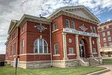 Hutchinson Public Carnegie Library |
June 25, 1987 (#87000968) |
427 N. Main 38°03′35″N 97°55′51″W |
Hutchinson | |
| 9 | Kelly Mills | 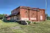 Kelly Mills |
April 16, 2008 (#08000304) |
400-414 S. Main St. 38°02′49″N 97°55′55″W |
Hutchinson | Commercial and Industrial Resources of Hutchinson MPS |
| 10 | G.W. Norris House | November 4, 2009 (#09000876) |
301 E. 12th Ave. 38°03′57″N 97°55′35″W |
Hutchinson | ||
| 11 | Ranson Hotel | November 20, 2008 (#08001067) |
4918 E. Main St. 38°08′54″N 97°50′52″W |
Medora | ||
| 12 | Reno County Courthouse | 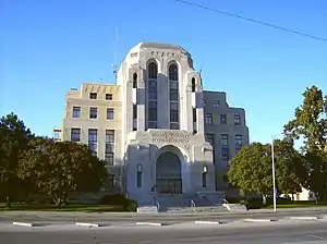 Reno County Courthouse |
April 13, 1987 (#86003530) |
206 W. 1st 38°03′17″N 97°56′04″W |
Hutchinson | |
| 13 | St. Teresa's Catholic Church | 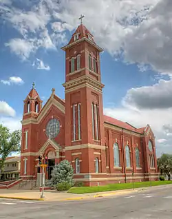 St. Teresa's Catholic Church |
April 29, 1994 (#94000390) |
211 E. 5th Ave. 38°03′33″N 97°55′38″W |
Hutchinson | |
| 14 | Soldiers and Sailors Memorial | 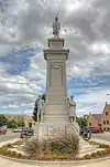 Soldiers and Sailors Memorial |
May 24, 2002 (#02000557) |
First Ave. and Walnut St. 38°03′12″N 97°55′47″W |
Hutchinson | |
| 15 | Sylvia Rural High School | November 17, 2005 (#05001247) |
203 Old K-50 37°57′25″N 98°24′33″W |
Sylvia | ||
| 16 | Terminal Station | 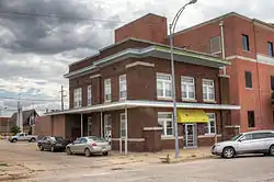 Terminal Station |
October 13, 1983 (#83003601) |
111 2nd Ave., E. 38°03′16″N 97°55′45″W |
Hutchinson | |
| 17 | US Post Office-Hutchinson | 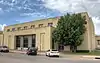 US Post Office-Hutchinson |
October 17, 1989 (#89001644) |
128 E. First St. 38°03′15″N 97°55′38″W |
Hutchinson | |
| 18 | Wall-Ratzlaff House | April 30, 1992 (#92000443) |
103 N. Maple 38°08′05″N 97°46′09″W |
Buhler | ||
| 19 | Frank D. Wolcott House | 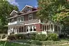 Frank D. Wolcott House |
May 6, 1994 (#94000408) |
100 W. 20th Ave. 38°04′33″N 97°56′00″W |
Hutchinson |
Former listings
| [3] | Name on the Register | Image | Date listed | Date removed | Location | City or town | Summary |
|---|---|---|---|---|---|---|---|
| 1 | Kansas Sugar Refining Company Mill | 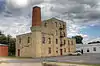 Kansas Sugar Refining Company Mill |
January 3, 1985 (#85000013) | March 18, 2020 | 600 E. 1st St. 38°03′14″N 97°55′04″W |
Hutchinson | |
| 2 | Plevna General Store | December 22, 1988 (#88002968) | February 25, 2004 | 3rd and Main |
Plevna |
See also
| Wikimedia Commons has media related to National Register of Historic Places in Reno County, Kansas. |
References
- The latitude and longitude information provided in this table was derived originally from the National Register Information System, which has been found to be fairly accurate for about 99% of listings. Some locations in this table may have been corrected to current GPS standards.
- "National Register of Historic Places: Weekly List Actions". National Park Service, United States Department of the Interior. Retrieved on January 29, 2021.
- Numbers represent an alphabetical ordering by significant words. Various colorings, defined here, differentiate National Historic Landmarks and historic districts from other NRHP buildings, structures, sites or objects.
- "National Register Information System". National Register of Historic Places. National Park Service. March 13, 2009.
- The eight-digit number below each date is the number assigned to each location in the National Register Information System database, which can be viewed by clicking the number.

Municipalities and communities of Reno County, Kansas, United States | ||
|---|---|---|
| Cities | Map of Kansas highlighting Reno County | |
| Unincorporated communities | ||
| Ghost towns | ||
| Townships | ||
| Footnotes | †This populated place is designated a Census-Designated Place (CDP) by the United States Census Bureau | |
| ||
This article is issued from Wikipedia. The text is licensed under Creative Commons - Attribution - Sharealike. Additional terms may apply for the media files.