National Register of Historic Places listings in Doniphan County, Kansas
This is a list of the National Register of Historic Places listings in Doniphan County, Kansas.

Location of Doniphan County in Kansas
This is intended to be a complete list of the properties and districts on the National Register of Historic Places in Doniphan County, Kansas, United States. The locations of National Register properties and districts for which the latitude and longitude coordinates are included below, may be seen in a map.[1]
There are 37 properties and districts listed on the National Register in the county. Five properties were once listed, but have since been delisted.
- This National Park Service list is complete through NPS recent listings posted January 29, 2021.[2]
Current listings
| [3] | Name on the Register[4] | Image | Date listed[5] | Location | City or town | Description |
|---|---|---|---|---|---|---|
| 1 | Albert Albers Barn | May 7, 1987 (#86003552) |
South of Bendena 39°41′13″N 95°10′52″W |
Bendena | ||
| 2 | Nicholas Bohr Barn | May 7, 1987 (#86003531) |
Southeast of Troy 39°43′35″N 95°02′49″W |
Troy | ||
| 3 | Brenner Vineyards Historic District | May 24, 2005 (#04001514) |
Southwest of the junction of Mineral Point and 95th Rds. 39°38′26″N 95°05′09″W |
Doniphan | ||
| 4 | Herman Chrystal Barn | May 7, 1987 (#86003538) |
West of Wathena 39°44′14″N 95°00′45″W |
Wathena | ||
| 5 | Doniphan Archeological Site | March 1, 1974 (#74000825) |
Address restricted |
Doniphan | ||
| 6 | Doniphan County Courthouse | 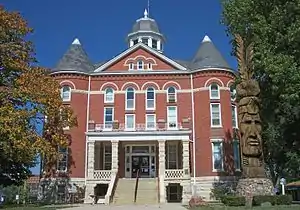 Doniphan County Courthouse |
July 15, 1974 (#74000826) |
Courthouse Sq., bounded by Walnut, Liberty, Chestnut, and Main Sts. 39°47′10″N 95°05′20″W |
Troy | |
| 7 | Doniphan County Courthouse Square Historic District | 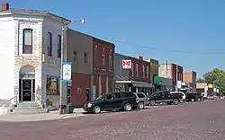 Doniphan County Courthouse Square Historic District |
July 3, 2002 (#02000717) |
Roughly bounded by E. Walnut, E. Chestnut, S. Main, and S. Liberty Sts. 39°47′10″N 95°05′21″W |
Troy | |
| 8 | Doniphan County Waddell Truss Bridge | 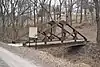 Doniphan County Waddell Truss Bridge |
January 4, 1990 (#89002185) |
Troy City Park, W. Myrtle St. 39°47′17″N 95°05′41″W |
Troy | |
| 9 | Mathew Eylar Barn No. 1 | May 7, 1987 (#86003549) |
South of Denton off K-20 39°39′15″N 95°15′47″W |
Denton | ||
| 10 | Mathew Eylar Barn No. 2 | May 7, 1987 (#86003550) |
Southeast of Denton off K-20 39°39′47″N 95°14′30″W |
Denton | ||
| 11 | Fanning Archeological Site | June 20, 1972 (#72000492) |
Address restricted |
Fanning | ||
| 12 | First National Bank Building | July 2, 2008 (#08000609) |
422-424 W. Main St. 39°51′35″N 95°16′08″W |
Highland | ||
| 13 | John R. Hale Barn | May 7, 1987 (#86003545) |
K-120 39°48′32″N 95°15′57″W |
Highland | ||
| 14 | George Hanson Barn | May 7, 1987 (#86003548) |
South of Leona 39°45′58″N 95°19′15″W |
Leona | ||
| 15 | Highland Christian Church | April 4, 2007 (#07000250) |
102 E. Main St. 39°51′35″N 95°15′53″W |
Highland | ||
| 16 | Highland Presbyterian Church | April 4, 2007 (#07000248) |
101 South Ave. 39°51′34″N 95°16′16″W |
Highland | ||
| 17 | Iowa, Sac, and Fox Presbyterian Mission | December 2, 1970 (#70000248) |
1.5 miles east of Highland on U.S. Route 36 and 0.2 miles north on K-136 39°51′51″N 95°13′45″W |
Highland | ||
| 18 | Irvin Hall, Highland Community Junior College | 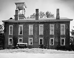 Irvin Hall, Highland Community Junior College |
February 24, 1971 (#71000307) |
Highland Community College campus 39°51′36″N 95°16′13″W |
Highland | |
| 19 | Fred W. Kienhoff Barn | May 7, 1987 (#86003537) |
West of Wathena 39°43′34″N 95°02′21″W |
Wathena | ||
| 20 | George Kinkhead Barn | 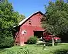 George Kinkhead Barn |
May 7, 1987 (#86003542) |
Off U.S. Route 36 39°47′31″N 95°05′05″W |
Troy | |
| 21 | Lincoln School, District 2 | 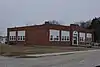 Lincoln School, District 2 |
June 27, 2014 (#14000348) |
410 N. 9th St. 39°45′31″N 94°52′51″W |
Elwood | |
| 22 | Abram M. Minier House | April 7, 2014 (#14000115) |
307 South Ave. 39°51′24″N 95°16′16″W |
Highland | Part of the Highland, Doniphan County, Kansas MPS | |
| 23 | Godfrey Nuzum Barn | May 7, 1987 (#86003533) |
K-7 39°53′27″N 95°12′37″W |
Sparks | ||
| 24 | Poulet House |  Poulet House |
September 3, 1971 (#71000308) |
Poplar St. between 1st and 2nd Sts. 39°58′41″N 95°17′49″W |
White Cloud | |
| 25 | St. Benedict's Church | April 9, 1998 (#98000324) |
5 miles southwest of Bendena 39°43′08″N 95°13′52″W |
Bendena | ||
| 26 | St. Martha's AME Church and Parsonage | July 20, 2000 (#00000757) |
101 S. Canada 39°51′34″N 95°15′43″W |
Highland | ||
| 27 | St. Mary's Catholic Church | April 25, 2001 (#01000413) |
446 K-137 39°40′54″N 95°19′49″W |
Purcell | ||
| 28 | John Silvers Barn | May 7, 1987 (#86003553) |
North of Wathena 39°49′56″N 94°57′33″W |
Wathena | ||
| 29 | Site No. RH00-062 |  Site No. RH00-062 |
June 19, 1987 (#87001001) |
6½ miles southeast of Rulo, Nebraska and 200 feet west of the road between White Cloud, Kansas and Rulo 40°00′00″N 95°19′55″W |
Iowa Township | Extends into Brown County, Kansas and Richardson County, Nebraska |
| 30 | John Streib Barn | May 7, 1987 (#86003547) |
North of Leona 39°47′38″N 95°19′13″W |
Leona | ||
| 31 | J.A. Symns Barn | 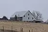 J.A. Symns Barn |
May 7, 1987 (#86003536) |
K-7 39°40′35″N 95°08′30″W |
Bendena | |
| 32 | Wathena Fruit Growers' Association Building | 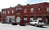 Wathena Fruit Growers' Association Building |
December 17, 2009 (#09001092) |
104 3rd St. 39°45′34″N 94°56′52″W |
Wathena | |
| 33 | T.L. White Barn | 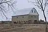 T.L. White Barn |
May 7, 1987 (#86003544) |
K-7 39°40′31″N 95°08′39″W |
Bendena | |
| 34 | White Cloud Historic District | 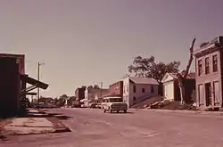 White Cloud Historic District |
June 28, 1996 (#96000701) |
Roughly bounded by Poplar, 6th, and Chesnut Sts. and K-7 39°58′34″N 95°17′49″W |
White Cloud | |
| 35 | White Cloud School | 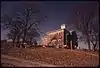 White Cloud School |
April 13, 1973 (#73000752) |
Southwestern corner of 5th and Main Sts. 39°58′30″N 95°17′59″W |
White Cloud | |
| 36 | M. D. L. Williams Barn | May 7, 1987 (#86003551) |
3 miles south of K-20 39°40′59″N 95°12′27″W |
Bendena | ||
| 37 | A.L. Wynkoop House | 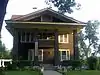 A.L. Wynkoop House |
April 4, 2007 (#07000251) |
307 W. Pennsylvania 39°51′27″N 95°16′05″W |
Highland |
Former listings
| [3] | Name on the Register | Image | Date listed | Date removed | Location | City or town | Summary |
|---|---|---|---|---|---|---|---|
| 1 | Dorland Building | December 1, 1978 (#78001278) | April 3, 1986 | Main St. |
White Cloud | ||
| 2 | Eclipse School | March 7, 1988 (#88000200) | December 16, 2004 | Off US 36 NE of Troy |
Troy vicinity | ||
| 3 | Benjamin Harding House | August 29, 1977 (#77000578) | December 16, 2004 | 308 N. 5th |
Wathena | ||
| 4 | Highland Water Tower | April 4, 2007 (#07000249) | December 29, 2015 | Junction of N. Genesee and W. Illinois Sts. 39°51′37″N 95°16′02″W |
Highland | ||
| 5 | Mission-Herring Barn | May 7, 1987 (#86003535) | December 16, 2004 | US 36 |
Highland vicinity |
See also
| Wikimedia Commons has media related to National Register of Historic Places in Doniphan County, Kansas. |
References
- The latitude and longitude information provided in this table was derived originally from the National Register Information System, which has been found to be fairly accurate for about 99% of listings. Some locations in this table may have been corrected to current GPS standards.
- "National Register of Historic Places: Weekly List Actions". National Park Service, United States Department of the Interior. Retrieved on January 29, 2021.
- Numbers represent an alphabetical ordering by significant words. Various colorings, defined here, differentiate National Historic Landmarks and historic districts from other NRHP buildings, structures, sites or objects.
- "National Register Information System". National Register of Historic Places. National Park Service. March 13, 2009.
- The eight-digit number below each date is the number assigned to each location in the National Register Information System database, which can be viewed by clicking the number.

Municipalities and communities of Doniphan County, Kansas, United States | ||
|---|---|---|
| Cities | Map of Kansas highlighting Doniphan County | |
| Unincorporated communities | ||
| Ghost town | ||
| Indian reservation | ||
| Townships | ||
| Footnotes | †This populated place is designated a Census-Designated Place (CDP) by the United States Census Bureau, ‡This populated place also has portions in an adjacent county or counties. | |
| ||
This article is issued from Wikipedia. The text is licensed under Creative Commons - Attribution - Sharealike. Additional terms may apply for the media files.