National Register of Historic Places listings in Morris County, Kansas
This is a list of the National Register of Historic Places listings in Morris County, Kansas.
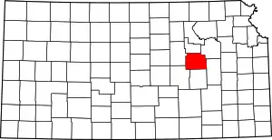
Location of Morris County in Kansas
This is intended to be a complete list of the properties and districts on the National Register of Historic Places in Morris County, Kansas, United States. The locations of National Register properties and districts for which the latitude and longitude coordinates are included below, may be seen in a map.[1]
There are 26 properties and districts listed on the National Register in the county, including 1 National Historic Landmark.
- This National Park Service list is complete through NPS recent listings posted January 29, 2021.[2]
Current listings
| [3] | Name on the Register[4] | Image | Date listed[5] | Location | City or town | Description |
|---|---|---|---|---|---|---|
| 1 | Big John Farm Limestone Bank Barn | October 25, 1990 (#90001576) |
North of U.S. Route 56, east of Big John Creek 38°40′07″N 96°26′53″W |
Council Grove | Built 1871-1872, the limestone barn measures 76 feet by 40 feet. The stone walls are two feet thick. The roof is of a double truss design of native oak. The property, at one time, was owned by Seth Hayes and it is likely he paid for its construction. | |
| 2 | Oscar Carlson House | 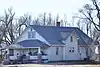 Oscar Carlson House |
May 26, 2000 (#00000533) |
K-2 38°32′11″N 96°52′53″W |
Burdick | Designed and built in 1930 by Swen Johnson and Oscar Carlson, this is a 1 1⁄2-story farmhouse bungalow containing many built-in features for convenience. |
| 3 | Cottage House Hotel | .jpg.webp) Cottage House Hotel |
August 4, 1988 (#88001172) |
25 N. Neosho 38°39′42″N 96°29′23″W |
Council Grove | |
| 4 | Council Grove Carnegie Library | 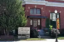 Council Grove Carnegie Library |
June 25, 1987 (#87000963) |
303 W. Main 38°39′35″N 96°29′37″W |
Council Grove | |
| 5 | Council Grove Downtown Historic District | 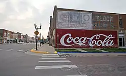 Council Grove Downtown Historic District |
July 30, 2010 (#10000519) |
Beginning at the Neosho River on W. Main St. to Belfry St. and extending north to Columbia St. between Neosho and Mission Streets 38°39′40″N 96°29′32″W |
Council Grove | The historic district contains seventy-one buildings dating from the mid and late 19th and early 20th century. The earliest building is Conn Mercantile constructed in 1853 and used as a general store and way station for travelers on the Santa Fe Trail. |
| 6 | Council Grove Historic District | 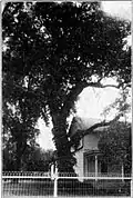 Council Grove Historic District |
October 15, 1966 (#66000347) |
U.S. Route 56 38°39′32″N 96°28′44″W |
Council Grove | Council Grove was named in 1825 when Government Survey Commissioners made treaties with Osage Indians which guaranteed safe passage for travelers on the Santa Fe Trail. |
| 7 | Council Grove Missouri, Kansas and Texas Depot | 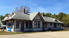 Council Grove Missouri, Kansas and Texas Depot |
October 11, 2001 (#01001092) |
512 E. Main St. 38°39′43″N 96°28′48″W |
Council Grove | The Victorian style depot for the Missouri, Kansas & Texas Railway (also M-K-T or Katy) was built in 1894. |
| 8 | Council Grove National Bank | 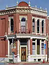 Council Grove National Bank |
June 3, 1976 (#76000834) |
130 W. Main 38°39′41″N 96°29′24″W |
Council Grove | Originally chartered in 1878 as the Morris County State Bank, in 1900 it received a national charter as the Council Grove National Bank. After a fire in 1886, the bank commissioned architect J. H. Leedy and builder Louis Peterson, both of Council Grove for a new building which was completed April 28, 1887. |
| 9 | Diamond Spring | September 30, 1976 (#76000835) |
6 miles west of Wilsey 38°36′58″N 96°45′44″W |
Wilsey | ||
| 10 | Dunlap Colored Cemetery | September 14, 2018 (#100002967) |
2050 S 100 Rd. 38°35′15″N 96°21′12″W |
Dunlap vicinity | ||
| 11 | Farmers and Drovers Bank | .jpg.webp) Farmers and Drovers Bank |
June 21, 1971 (#71000321) |
201 and 203 W. Main St. 38°39′51″N 96°29′21″W |
Council Grove | Originally just 201 W. Main; 203 W. Main added in boundary increase of February 19, 1982 |
| 12 | First Baptist Church | 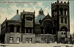 First Baptist Church |
July 28, 1995 (#95000915) |
325 W. Main St. 38°39′35″N 96°29′34″W |
Council Grove | |
| 13 | Four Mile Creek Lattice | .jpg.webp) Four Mile Creek Lattice |
January 4, 1990 (#89002181) |
Over Four Mile Creek, southeast of Wilsey 38°36′33″N 96°39′21″W |
Wilsey | |
| 14 | Furney Farm | July 12, 2006 (#06000596) |
649 E. K-56 38°39′45″N 96°27′15″W |
Council Grove | ||
| 15 | Greenwood Cemetery | February 3, 2020 (#100004926) |
West Main St. 38°39′30″N 96°30′04″W |
Council Grove | ||
| 16 | Seth Hays House | 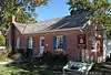 Seth Hays House |
September 25, 1975 (#75000718) |
203 Wood St. 38°39′32″N 96°29′18″W |
Council Grove | Seth Hayes came to Council Grove in 1847, achieving success as merchant and later, owner of the Hayes House tavern and hotel. The brick house, built in 1866-1867, was home for Seth Hayes, his adopted daughter Kittie Parker Robbins Hayes, and his housekeeper, a freed slave “Aunt Sallie” Taylor. The home is now a museum and contributing property to the Council Grove Historic District. |
| 17 | Hermit's Cave on Belfry Hill | April 14, 2015 (#15000148) |
E. of N. Belfry St., generally from Columbia to Conn Sts. 38°39′44″N 96°29′39″W |
Council Grove | ||
| 18 | Jenkins Building | 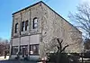 Jenkins Building |
May 19, 2004 (#04000451) |
101 W. Mackenzie St. 38°47′44″N 96°44′08″W |
White City | |
| 19 | Last Chance Store | 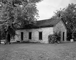 Last Chance Store |
June 21, 1971 (#71000322) |
500 W. Main St. 38°39′47″N 96°29′35″W |
Council Grove | A contributing property to the Council Grove Historic District |
| 20 | Little John Creek Reserve | October 21, 2001 (#01001125) |
South of Council Grove around Little John Creek, E. 1/2, Sec. 29, T 16 S, R 9 E 38°37′47″N 96°25′16″W |
Council Grove | From 1846 to 1873, the land was a reserve for the Kansa Indians. The reserve was, for a short period, childhood home to Charles Curtis, representative and senator from Kansas, and, later, Vice President of the United States. | |
| 21 | Madonna of the Trail | 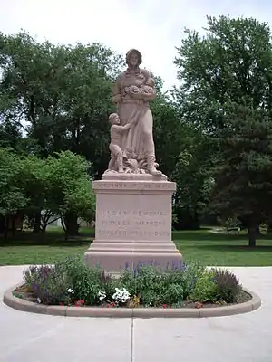 Madonna of the Trail |
March 26, 2018 (#100002245) |
11 E. Main St. 38°39′43″N 96°29′13″W |
Council Grove | |
| 22 | Old Kaw Mission | 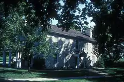 Old Kaw Mission |
March 24, 1971 (#71000323) |
500 N. Mission St. 38°39′57″N 96°29′38″W |
Council Grove | |
| 23 | Simcock House | March 11, 1982 (#82004888) |
206-208 Columbia St. 38°39′43″N 96°29′29″W |
Council Grove | ||
| 24 | Six Mile Creek Stage Station Historic District | 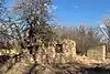 Six Mile Creek Stage Station Historic District |
May 11, 1995 (#95000585) |
600 feet east of FAS Highway 468, 4¼ miles south of junction with U.S. Route 56 38°36′20″N 96°51′16″W |
Burdick | |
| 25 | US Post Office-Council Grove | 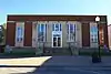 US Post Office-Council Grove |
October 17, 1989 (#89001636) |
103 W. Main St. 38°39′39″N 96°29′16″W |
Council Grove | |
| 26 | William Young Archeological Site | February 24, 1971 (#71000324) |
Address Restricted |
Council Grove |
See also
| Wikimedia Commons has media related to National Register of Historic Places in Morris County, Kansas. |
References
- The latitude and longitude information provided in this table was derived originally from the National Register Information System, which has been found to be fairly accurate for about 99% of listings. Some locations in this table may have been corrected to current GPS standards.
- "National Register of Historic Places: Weekly List Actions". National Park Service, United States Department of the Interior. Retrieved on January 29, 2021.
- Numbers represent an alphabetical ordering by significant words. Various colorings, defined here, differentiate National Historic Landmarks and historic districts from other NRHP buildings, structures, sites or objects.
- "National Register Information System". National Register of Historic Places. National Park Service. March 13, 2009.
- The eight-digit number below each date is the number assigned to each location in the National Register Information System database, which can be viewed by clicking the number.

Municipalities and communities of Morris County, Kansas, United States | ||
|---|---|---|
| Cities | Map of Kansas highlighting Morris County | |
| Unincorporated communities | ||
| Ghost towns | ||
| Townships |
| |
| Footnotes | ‡This populated place also has portions in an adjacent county or counties | |
| ||
This article is issued from Wikipedia. The text is licensed under Creative Commons - Attribution - Sharealike. Additional terms may apply for the media files.