National Register of Historic Places listings in Crawford County, Kansas
This is a list of the National Register of Historic Places listings in Crawford County, Kansas.
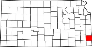
Location of Crawford County in Kansas
This is intended to be a complete list of the properties and districts on the National Register of Historic Places in Crawford County, Kansas, United States. The locations of National Register properties and districts for which the latitude and longitude coordinates are included below, may be seen in a map.[1]
There are 21 properties and districts listed on the National Register in the county.
- This National Park Service list is complete through NPS recent listings posted February 5, 2021.[2]
Current listings
| [3] | Name on the Register[4] | Image | Date listed[5] | Location | City or town | Description |
|---|---|---|---|---|---|---|
| 1 | Besse Hotel | 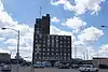 Besse Hotel |
April 16, 2008 (#08000300) |
121 E. 4th St. 37°31′14″N 94°50′36″W |
Pittsburg | |
| 2 | Cato District No. 4 School | September 6, 2006 (#06000771) |
Junction of 200th St. and 720th Ave. 37°40′01″N 94°44′30″W |
Cato | ||
| 3 | Colonial Fox Theatre | 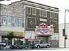 Colonial Fox Theatre |
April 16, 2008 (#08000301) |
409 N. Broadway 37°24′40″N 94°42′17″W |
Pittsburg | |
| 4 | Crawford County Courthouse | 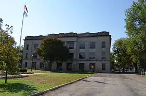 Crawford County Courthouse |
April 22, 2009 (#09000225) |
111 E. Forest, Courthouse Square 37°30′39″N 94°50′36″W |
Girard | |
| 5 | First Presbyterian Church | 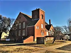 First Presbyterian Church |
July 8, 2009 (#09000496) |
202 N. Summit 37°30′39″N 94°50′36″W |
Girard | |
| 6 | Fourth and Broadway Historic District | October 11, 2016 (#16000703) |
401-424 N. Broadway, 105 and 121 E. 4th Sts. 37°24′41″N 94°42′17″W |
Pittsburg | ||
| 7 | Franklin Sidewalk | 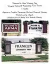 Franklin Sidewalk |
March 16, 2007 (#07000143) |
Parallel to Business Route 69 between Franklin and Arma 37°32′00″N 94°42′17″W |
Franklin | |
| 8 | Frisco Freight Depot | July 10, 2017 (#100001286) |
210 E. 4th St. 37°24′40″N 94°42′09″W |
Pittsburg | ||
| 9 | Girard Carnegie Library | 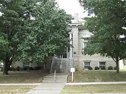 Girard Carnegie Library |
June 25, 1987 (#87000952) |
128 W. Prairie 37°30′37″N 94°50′42″W |
Girard | |
| 10 | Hotel Stilwell | 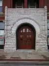 Hotel Stilwell |
April 30, 1980 (#80001464) |
707 Broadway 37°24′51″N 94°42′19″W |
Pittsburg | |
| 11 | Hudgeon Bridge | July 2, 1985 (#85001433) |
10 miles south and 3.2 miles west of Girard 37°22′08″N 94°53′56″W |
Girard | ||
| 12 | J.T and Anna Leonard House | 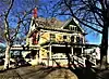 J.T and Anna Leonard House |
January 11, 2017 (#100000505) |
211 N. Summit St. 37°30′44″N 94°50′37″W |
Girard | |
| 13 | Little Walnut Creek Bowstring | January 4, 1990 (#89002174) |
Over Little Walnut Creek, northeast of Walnut 37°38′43″N 95°02′45″W |
Walnut | ||
| 14 | Pittsburg Public Library | Pittsburg Public Library |
November 9, 1977 (#77000577) |
4th and Walnut Sts. 37°24′40″N 94°42′26″W |
Pittsburg | |
| 15 | J. E. Raymond House | April 3, 2007 (#07000255) |
301 Osage St. 37°30′28″N 94°50′43″W |
Girard | ||
| 16 | S-W Supply Company | 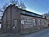 S-W Supply Company |
May 21, 2009 (#09000348) |
215 E. Prairie Ave. 37°30′34″N 94°50′29″W |
Girard | |
| 17 | St. John's Episcopal Church | 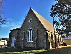 St. John's Episcopal Church |
April 22, 2009 (#09000226) |
Southeastern corner of Buffalo and Summit 37°30′29″N 94°50′35″W |
Girard | |
| 18 | State Bank of Girard | 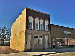 State Bank of Girard |
August 7, 2009 (#09000349) |
105 E. Prairie 37°30′34″N 94°50′36″W |
Girard | |
| 19 | Washington Grade School | April 16, 2008 (#08000302) |
209 S. Locust St. 37°24′26″N 94°42′12″W |
Pittsburg | ||
| 20 | Julius A. Wayland House | 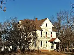 Julius A. Wayland House |
November 21, 1976 (#76000819) |
721 N. Summit 37°31′14″N 94°50′36″W |
Girard | |
| 21 | Whitesitt-Shirk Historic District | Whitesitt-Shirk Historic District |
March 20, 2002 (#02000204) |
116 E. Lindburg and 120 E. Lindburg 37°23′31″N 94°42′15″W |
Pittsburg |
See also
| Wikimedia Commons has media related to National Register of Historic Places in Crawford County, Kansas. |
References
- The latitude and longitude information provided in this table was derived originally from the National Register Information System, which has been found to be fairly accurate for about 99% of listings. Some locations in this table may have been corrected to current GPS standards.
- "National Register of Historic Places: Weekly List Actions". National Park Service, United States Department of the Interior. Retrieved on February 5, 2021.
- Numbers represent an alphabetical ordering by significant words. Various colorings, defined here, differentiate National Historic Landmarks and historic districts from other NRHP buildings, structures, sites or objects.
- "National Register Information System". National Register of Historic Places. National Park Service. March 13, 2009.
- The eight-digit number below each date is the number assigned to each location in the National Register Information System database, which can be viewed by clicking the number.

Municipalities and communities of Crawford County, Kansas, United States | ||
|---|---|---|
| Cities | Map of Kansas highlighting Crawford County | |
| Unincorporated communities | ||
| Townships | ||
| Footnotes | †This populated place is designated a Census-Designated Place (CDP) by the United States Census Bureau, ‡This populated place also has portions in an adjacent county or counties. | |
| ||
This article is issued from Wikipedia. The text is licensed under Creative Commons - Attribution - Sharealike. Additional terms may apply for the media files.