National Register of Historic Places listings in Riley County, Kansas
This is a list of the National Register of Historic Places listings in Riley County, Kansas.
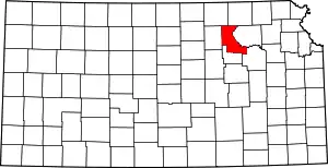
Location of Riley County in Kansas
This is intended to be a complete list of the properties and districts on the National Register of Historic Places in Riley County, Kansas, United States. The locations of National Register properties and districts for which the latitude and longitude coordinates are included below, may be seen in a map.[1]
There are 37 properties and districts listed on the National Register in the county.
- This National Park Service list is complete through NPS recent listings posted January 29, 2021.[2]
Current listings
| [3] | Name on the Register[4] | Image | Date listed[5] | Location | City or town | Description |
|---|---|---|---|---|---|---|
| 1 | Anderson Hall | 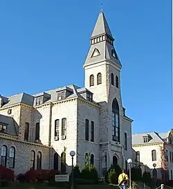 Anderson Hall |
November 28, 1980 (#80001471) |
Kansas State University campus 39°11′19″N 96°34′50″W |
Manhattan | |
| 2 | The Avalon | The Avalon |
September 30, 2019 (#100004453) |
417 Fremont St. 39°11′01″N 96°33′45″W |
Manhattan | |
| 3 | Bethel A.M.E. Church | 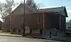 Bethel A.M.E. Church |
May 30, 2012 (#12000301) |
401 Yuma St. 39°10′30″N 96°33′44″W |
Manhattan | |
| 4 | Bluemont Youth Cabin | Bluemont Youth Cabin |
January 8, 2014 (#13001044) |
NE. of 5th & Bertrand Sts. in Goodnow Park 39°11′30″N 96°33′46″W |
Manhattan | Part of the New Deal-Era Resources of Kansas MPS |
| 5 | Community House | 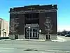 Community House |
November 21, 2006 (#06001051) |
120 N. 4th St. 39°10′55″N 96°33′42″W |
Manhattan | |
| 6 | Downtown Manhattan Historic District | 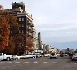 Downtown Manhattan Historic District |
October 2, 2007 (#06001240) |
Generally including the blocks between Humboldt and Pierre Sts. from 3rd to 5th Sts. 39°10′44″N 96°33′42″W |
Manhattan | |
| 7 | Mattie M. Elliot House | 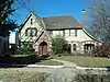 Mattie M. Elliot House |
June 2, 1995 (#95000672) |
600 Houston St. 39°10′42″N 96°33′55″W |
Manhattan | |
| 8 | First Congregational Church | 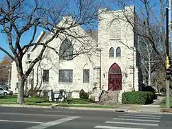 First Congregational Church |
November 13, 2008 (#08001068) |
700 Poyntz Ave. 39°10′46″N 96°34′02″W |
Manhattan | |
| 9 | Leslie A. Fitz House | 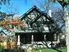 Leslie A. Fitz House |
June 8, 2005 (#05000543) |
1014 Houston St. 39°10′43″N 96°34′21″W |
Manhattan | |
| 10 | Goodnow House | 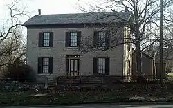 Goodnow House |
February 24, 1971 (#71000326) |
2301 Claflin Rd. 39°11′34″N 96°35′44″W |
Manhattan | |
| 11 | Grimes House | .jpg.webp) Grimes House |
May 9, 1997 (#97000409) |
203 North Delaware Ave. 39°10′58″N 96°35′14″W |
Manhattan | |
| 12 | Hartford House | 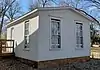 Hartford House |
September 30, 2019 (#100004452) |
2309 Claflin Rd. 39°11′35″N 96°35′47″W |
Manhattan | |
| 13 | Houston and Pierre Streets Residential Historic District | 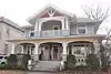 Houston and Pierre Streets Residential Historic District |
February 18, 2009 (#09000031) |
Bounded by S. 5th St., Pierre St., S. 9th St., and Houston St. 39°10′40″N 96°34′01″W |
Manhattan | |
| 14 | Samuel D. Houston House | 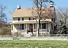 Samuel D. Houston House |
January 17, 2007 (#06001246) |
3624 Anderson Ave. 39°11′20″N 96°37′50″W |
Manhattan | |
| 15 | Hulse-Daughters House | 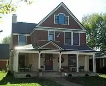 Hulse-Daughters House |
June 27, 2007 (#07000601) |
617 Colorado St. 39°10′41″N 96°33′59″W |
Manhattan | |
| 16 | Jesse Ingraham House | 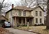 Jesse Ingraham House |
January 8, 2014 (#13001045) |
1724 Fairchild Ave. 39°11′03″N 96°35′04″W |
Manhattan | Part of the Late 19th Century Vernacular Stone Houses in Manhattan, Kansas MPS |
| 17 | KSAC Radio Towers | 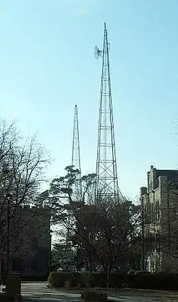 KSAC Radio Towers |
August 27, 1983 (#83000437) |
Kansas State University campus 39°11′13″N 96°34′53″W |
Manhattan | |
| 18 | Francis Byron (Barney) Kimble House | 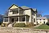 Francis Byron (Barney) Kimble House |
October 2, 2015 (#15000691) |
720 Poyntz Ave. 39°10′46″N 96°34′04″W |
Manhattan | |
| 19 | Landmark Water Tower | 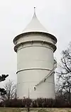 Landmark Water Tower |
October 4, 2017 (#100001704) |
Sunset Ave. & Leavenworth St. 39°10′52″N 96°35′19″W |
Manhattan | |
| 20 | Lyda-Jean Apartments | 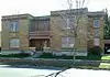 Lyda-Jean Apartments |
April 28, 2004 (#04000368) |
501 Houston St. 39°10′48″N 96°33′50″W |
Manhattan | |
| 21 | Manhattan Carnegie Library Building | 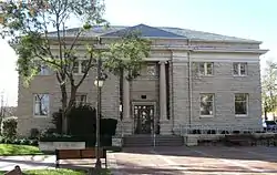 Manhattan Carnegie Library Building |
June 25, 1987 (#87000970) |
5th St. and Poyntz Ave. 39°10′46″N 96°33′48″W |
Manhattan | |
| 22 | McFarlane-Wareham House | 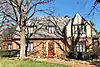 McFarlane-Wareham House |
July 21, 2004 (#04000724) |
1906 Leavenworth St. 39°11′01″N 96°35′13″W |
Manhattan | |
| 23 | Persons Barn and Granary | 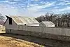 Persons Barn and Granary |
January 22, 2009 (#08001351) |
2103 K-18 (Zeandale Road) 39°09′16″N 96°30′33″W |
Manhattan | On the Lazy T Ranch |
| 24 | Pioneer Log Cabin | .jpg.webp) Pioneer Log Cabin |
February 3, 2020 (#100002969) |
405 N 11th St. (Manhattan City Park) 39°10′53″N 96°34′31″W |
Manhattan | |
| 25 | Jeremiah Platt House | 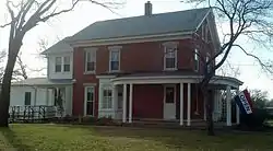 Jeremiah Platt House |
May 20, 1981 (#81000281) |
2005 Claflin Rd. 39°11′33″N 96°35′23″W |
Manhattan | |
| 26 | Riley County Courthouse | _County_Courthouse_1.jpg.webp) Riley County Courthouse |
November 15, 2005 (#05001249) |
100 Courthouse Plaza 39°10′54″N 96°33′47″W |
Manhattan | |
| 27 | Rocky Ford School | 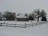 Rocky Ford School |
January 20, 2012 (#11001033) |
1669 Barnes Rd. 39°13′44″N 96°35′01″W |
Manhattan | |
| 28 | Damon Runyon House | 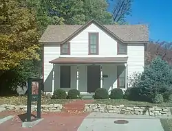 Damon Runyon House |
December 2, 2004 (#04001282) |
400 Osage St. 39°11′04″N 96°33′43″W |
Manhattan | |
| 29 | Second Baptist Church | 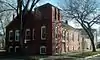 Second Baptist Church |
May 30, 2012 (#12000302) |
831 Yuma St. 39°10′30″N 96°34′12″W |
Manhattan | |
| 30 | Seven Dolors Catholic Church |  Seven Dolors Catholic Church |
September 1, 1995 (#95001054) |
Northeast of the junction of Juliette and Pierre Sts. 39°10′39″N 96°33′57″W |
Manhattan | |
| 31 | Strasser House | 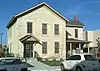 Strasser House |
July 6, 2010 (#10000431) |
326 Laramie St. 39°11′05″N 96°33′41″W |
Manhattan | |
| 32 | Robert Ulrich House | 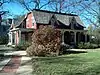 Robert Ulrich House |
September 20, 1978 (#78001287) |
121 N. 8th St. 39°10′49″N 96°34′06″W |
Manhattan | |
| 33 | Daniel and Maude Walters House | 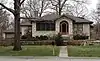 Daniel and Maude Walters House |
October 17, 2012 (#12000868) |
100 S. Delaware Ave. 39°10′46″N 96°35′13″W |
Manhattan | |
| 34 | E. A. and Ura Wharton House | 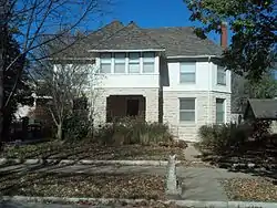 E. A. and Ura Wharton House |
June 20, 1995 (#95000740) |
608 Houston St. 39°10′50″N 96°33′56″W |
Manhattan | |
| 35 | Wolf House Historic District | 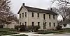 Wolf House Historic District |
March 7, 2019 (#100003425) |
630 Fremont St. 39°11′01″N 96°33′59″W |
Manhattan | |
| 36 | Woman's Club House | 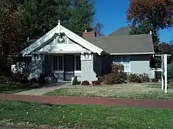 Woman's Club House |
November 28, 1980 (#80001472) |
900 Poyntz Ave. 39°10′46″N 96°34′13″W |
Manhattan | |
| 37 | Young Buck Site | January 27, 2015 (#14001211) |
Address Restricted |
Manhattan vicinity |
See also
| Wikimedia Commons has media related to National Register of Historic Places in Riley County, Kansas. |
References
- The latitude and longitude information provided in this table was derived originally from the National Register Information System, which has been found to be fairly accurate for about 99% of listings. Some locations in this table may have been corrected to current GPS standards.
- "National Register of Historic Places: Weekly List Actions". National Park Service, United States Department of the Interior. Retrieved on January 29, 2021.
- Numbers represent an alphabetical ordering by significant words. Various colorings, defined here, differentiate National Historic Landmarks and historic districts from other NRHP buildings, structures, sites or objects.
- "National Register Information System". National Register of Historic Places. National Park Service. March 13, 2009.
- The eight-digit number below each date is the number assigned to each location in the National Register Information System database, which can be viewed by clicking the number.

Municipalities and communities of Riley County, Kansas, United States | ||
|---|---|---|
| Cities | Map of Kansas highlighting Riley County | |
| Unincorporated communities | ||
| Footnotes | †This populated place is designated a Census-Designated Place (CDP) by the United States Census Bureau, ‡This populated place also has portions in an adjacent county or counties. | |
| ||
This article is issued from Wikipedia. The text is licensed under Creative Commons - Attribution - Sharealike. Additional terms may apply for the media files.