National Register of Historic Places listings in Marshall County, Kansas
This is a list of the National Register of Historic Places listings in Marshall County, Kansas.
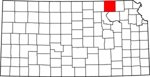
Location of Marshall County in Kansas
This is intended to be a complete list of the properties and districts on the National Register of Historic Places in Marshall County, Kansas, United States. The locations of National Register properties and districts for which the latitude and longitude coordinates are included below, may be seen in a map.[1]
There are 21 properties and districts listed on the National Register in the county.
- This National Park Service list is complete through NPS recent listings posted February 5, 2021.[2]
Current listings
| [3] | Name on the Register[4] | Image | Date listed[5] | Location | City or town | Description |
|---|---|---|---|---|---|---|
| 1 | Alcove Springs | 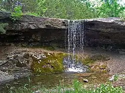 Alcove Springs |
February 23, 1972 (#72000513) |
4 miles (6.4 km) north of Blue Rapids; E. River Rd 39°44′56″N 96°40′35″W |
Blue Rapids | Boundary increase September 25, 2013 |
| 2 | Barrett Schoolhouse | 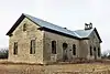 Barrett Schoolhouse |
March 14, 1973 (#73000766) |
4 miles (6.4 km) southwest of Frankfort on K-99 39°39′59″N 96°27′06″W |
Frankfort | |
| 3 | Blue Rapids Library | March 17, 1972 (#72000514) |
Eastern side of the public square 39°40′55″N 96°39′29″W |
Blue Rapids | ||
| 4 | Frankfort School | 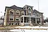 Frankfort School |
December 27, 1972 (#72000515) |
400 Locust St. 39°42′17″N 96°25′01″W |
Frankfort | |
| 5 | Perry Hutchinson House | _from_NE_1.JPG.webp) Perry Hutchinson House |
April 13, 1972 (#72000516) |
1 mile (1.6 km) northwest of Marysville on U.S. Route 77 39°51′02″N 96°40′02″W |
Marysville | |
| 6 | Koester Block Historic District | .jpg.webp) Koester Block Historic District |
December 5, 1980 (#80001469) |
Between 9th, 10th, Elm, and Broadway Sts. 39°50′29″N 96°38′44″W |
Marysville | |
| 7 | Charles Koester House | 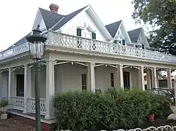 Charles Koester House |
May 12, 1975 (#75000715) |
919 Broadway 39°50′29″N 96°38′44″W |
Marysville | |
| 8 | Marshall County Courthouse | 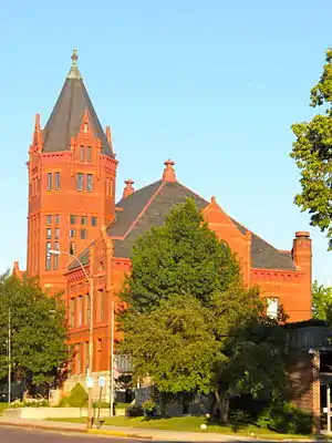 Marshall County Courthouse |
November 5, 1974 (#74000843) |
1207 Broadway 39°50′32″N 96°38′31″W |
Marysville | |
| 9 | Marysville High School-Junior High School Complex |  Marysville High School-Junior High School Complex |
January 2, 2013 (#12001120) |
1011-1111 Walnut St. 39°50′23″N 96°38′41″W |
Marysville | |
| 10 | Marysville Pony Express Barn | 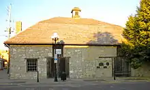 Marysville Pony Express Barn |
April 2, 1973 (#73000767) |
108 S. 8th St. 39°50′27″N 96°38′51″W |
Marysville | |
| 11 | Marysville Union Pacific Depot | 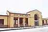 Marysville Union Pacific Depot |
October 11, 2016 (#16000709) |
000 Hedrix Ave. (at Alston St.) 39°50′39″N 96°38′56″W |
Marysville | |
| 12 | Z. H. Moore Store | 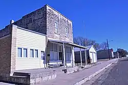 Z. H. Moore Store |
June 24, 1976 (#76000830) |
State and Center Sts. 39°57′53″N 96°36′01″W |
Oketo | |
| 13 | Old Frankfort City Jail | 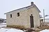 Old Frankfort City Jail |
November 1, 1982 (#82000418) |
Railway Ave. 39°42′05″N 96°25′02″W |
Frankfort | |
| 14 | Oregon and California Trail--Pacha Ruts | January 8, 2014 (#13001040) |
Address Restricted |
Bremen vicinity | ||
| 15 | Samuel Powell House | December 27, 1972 (#72000517) |
108 W. Commercial St. 39°41′34″N 96°44′59″W |
Waterville | ||
| 16 | Pusch-Randell House | .jpg.webp) Pusch-Randell House |
September 22, 1986 (#86002680) |
1000 Elm St. 39°50′30″N 96°38′48″W |
Marysville | |
| 17 | Robidoux Creek Pratt Truss Bridge | 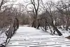 Robidoux Creek Pratt Truss Bridge |
May 22, 2003 (#03000474) |
Sunflower Rd., 0.8 miles (1.3 km) west of its junction with 21st Rd., northwest of Frankfort 39°43′33″N 96°26′26″W |
Frankfort | |
| 18 | St. Bridget Church | 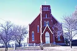 St. Bridget Church |
September 12, 1996 (#96001011) |
Rural Route 2, 6.5 miles (10.5 km) north of Axtell 39°57′58″N 96°15′48″W |
St. Bridget Township | |
| 19 | Transue Brothers Blacksmith & Wagon Shop | Transue Brothers Blacksmith & Wagon Shop |
December 30, 2009 (#09001164) |
309 Main St. 39°59′54″N 96°20′55″W |
Summerfield | |
| 20 | Waterville Opera House | 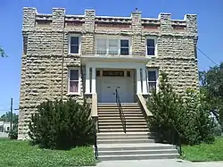 Waterville Opera House |
October 16, 2008 (#08000984) |
200 E. Front St. 39°41′29″N 96°44′51″W |
Waterville | |
| 21 | Weaver Hotel |  Weaver Hotel |
August 28, 1975 (#75000716) |
126 S. Kansas St. 39°41′30″N 96°44′51″W |
Waterville |
See also
| Wikimedia Commons has media related to National Register of Historic Places in Marshall County, Kansas. |
References
- The latitude and longitude information provided in this table was derived originally from the National Register Information System, which has been found to be fairly accurate for about 99% of listings. Some locations in this table may have been corrected to current GPS standards.
- "National Register of Historic Places: Weekly List Actions". National Park Service, United States Department of the Interior. Retrieved on February 5, 2021.
- Numbers represent an alphabetical ordering by significant words. Various colorings, defined here, differentiate National Historic Landmarks and historic districts from other NRHP buildings, structures, sites or objects.
- "National Register Information System". National Register of Historic Places. National Park Service. March 13, 2009.
- The eight-digit number below each date is the number assigned to each location in the National Register Information System database, which can be viewed by clicking the number.

Municipalities and communities of Marshall County, Kansas, United States | ||
|---|---|---|
| Cities | Map of Kansas highlighting Marshall County | |
| Unincorporated communities | ||
| Ghost towns | ||
| Townships | ||
| Footnotes | †This populated place is designated a Census-Designated Place (CDP) by the United States Census Bureau | |
| ||
This article is issued from Wikipedia. The text is licensed under Creative Commons - Attribution - Sharealike. Additional terms may apply for the media files.