National Register of Historic Places listings in Butler County, Kansas
This is a list of the National Register of Historic Places listings in Butler County, Kansas.
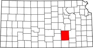
Location of Butler County in Kansas
This is intended to be a complete list of the properties on the National Register of Historic Places in Butler County, Kansas, United States. The locations of National Register properties for which the latitude and longitude coordinates are included below, may be seen in a map.[1]
There are 27 properties listed on the National Register in the county.
- This National Park Service list is complete through NPS recent listings posted February 5, 2021.[2]
Current listings
| [3] | Name on the Register[4] | Image | Date listed[5] | Location | City or town | Description |
|---|---|---|---|---|---|---|
| 1 | Augusta Theater | October 31, 1990 (#90001577) |
525 State St. 37°40′37″N 96°59′22″W |
Augusta | ||
| 2 | Beaumont Hotel | February 3, 2012 (#11001078) |
11651 SE Main St. 37°39′21″N 96°31′58″W |
Beaumont | ||
| 3 | Beaumont St. Louis and San Francisco Railroad Retention Pond | October 6, 2011 (#11000724) |
SE 116th St. & SE Beaumont Rd. 37°39′19″N 96°32′06″W |
Beaumont | ||
| 4 | Beaumont St. Louis and San Francisco Railroad Water Tank | 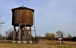 Beaumont St. Louis and San Francisco Railroad Water Tank |
August 19, 1993 (#93000843) |
Junction of 3rd and D Sts. 37°39′18″N 96°31′51″W |
Beaumont | Built in 1875, in Beaumont, Kansas, serving steam locomotives on the St. Louis, Wichita & Western Railway. |
| 5 | Butler County Courthouse | 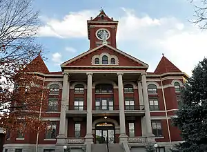 Butler County Courthouse |
April 26, 2002 (#02000390) |
205 W. Central Ave. 37°49′01″N 96°51′06″W |
El Dorado | On December 3, 1908, the corner stone was laid; construction was completed the following year. Architects, George P. Washburn & Sons of Ottawa. |
| 6 | Creed-Mills House | June 25, 2013 (#13000430) |
219 North Maple Street 37°31′17″N 97°01′05″W |
Douglass | ||
| 7 | Douglass Township Community Building | 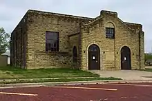 Douglass Township Community Building |
April 27, 1995 (#95000512) |
206 S. Forest 37°31′05″N 97°00′56″W |
Douglass | |
| 8 | El Dorado Carnegie Library | 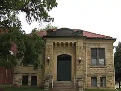 El Dorado Carnegie Library |
June 25, 1987 (#87000931) |
101 S. Star 37°49′00″N 96°51′17″W |
El Dorado | |
| 9 | El Dorado Historic District | 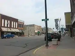 El Dorado Historic District |
October 30, 2013 (#13000855) |
Roughly 1 blk. E. & W. of N. & S. Main Sts. from E. 3rd to E. Locust Aves. 37°49′03″N 96°50′59″W |
El Dorado | |
| 10 | El Dorado Missouri Pacific Depot | 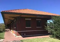 El Dorado Missouri Pacific Depot |
May 6, 1994 (#94000429) |
430 N. Main St. 37°49′18″N 96°50′57″W |
El Dorado | A one-story red-brick building with a red-tile roof and wide, overhanging eaves, designed by E. M. Tucker, Chief Engineer of the Missouri Pacific, in the Mission architectural style. Built in 1918. |
| 11 | First Presbyterian Church of De Graff | June 27, 2014 (#14000346) |
1145 NW. 108th St, Burns, KS (mailing address) 37°58′51″N 96°51′44″W |
De Graff | ||
| 12 | Amos H. Gish Building |  Amos H. Gish Building |
July 3, 2012 (#12000383) |
317 S. Main 37°48′54″N 96°51′01″W |
El Dorado | In 1917, Amos Gish commissioned T.R. Reed to build the Amos H. Gish Building. Amos Gish operated his veterinary practice and lived with his family on the second-story and leased the first-story front to retail and the rear as garage space to auto and storage businesses. |
| 13 | C. N. James Cabin | 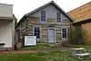 C. N. James Cabin |
April 13, 1973 (#73000745) |
305 State St. 37°39′53″N 96°58′46″W |
Augusta | |
| 14 | Little Walnut River Pratt Truss Bridge | 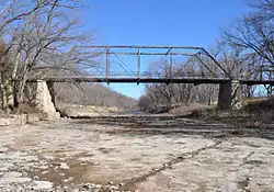 Little Walnut River Pratt Truss Bridge |
May 9, 2003 (#03000377) |
SW. 160th Rd., ½ mile west of its intersection with Purity Springs Rd. 37°35′46″N 96°55′24″W |
Bois D'Arc | |
| 15 | Loomis-Parry Residence | July 8, 2009 (#09000495) |
1003 State St. 37°40′56″N 96°58′44″W |
Augusta | ||
| 16 | John Moyle Building | 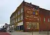 John Moyle Building |
June 27, 2014 (#14000347) |
605 & 607 N. State St. 37°40′40″N 96°58′45″W |
Augusta | |
| 17 | Muddy Creek Bridge | July 2, 1985 (#85001425) |
Off U.S. Route 77 37°32′03″N 96°57′04″W |
Douglass | ||
| 18 | Oak Lawn Farm Dairy Barn | November 5, 2005 (#05001202) |
12464 NW. Meadowlark 38°00′24″N 97°05′46″W |
Whitewater | ||
| 19 | James T. Oldham House | 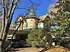 James T. Oldham House |
November 21, 2006 (#06001054) |
321 S. Denver St. 37°48′53″N 96°51′23″W |
El Dorado | |
| 20 | Polecat Creek Bridge |  Polecat Creek Bridge |
July 2, 1985 (#85001438) |
5 miles west and 2 miles south of Douglass 37°29′23″N 97°06′33″W |
Douglass | |
| 21 | Ray L. Smith House | 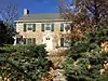 Ray L. Smith House |
January 7, 2015 (#14001117) |
812 W. Central Ave. 37°49′03″N 96°51′37″W |
El Dorado | |
| 22 | Towanda Masonic Lodge No. 30 A.F. and A.M. | January 14, 2004 (#03001392) |
401 Main St. 37°47′44″N 97°00′09″W |
Towanda | ||
| 23 | US Post Office-Augusta | October 17, 1989 (#89001632) |
119 E. 5th St. 37°40′33″N 96°58′38″W |
Augusta | ||
| 24 | Viets Block | April 16, 2012 (#12000202) |
427, 429, & 431 State St. 37°40′34″N 96°58′45″W |
Augusta | ||
| 25 | Walnut River Crossing of the Cherokee/Fayetteville Oregon-California Trail | September 30, 2019 (#100004457) |
Address Restricted |
El Dorado | ||
| 26 | Whitewater Falls Stock Farm | October 8, 2014 (#14000828) |
433 Falls Rd. 37°49′53″N 97°02′20″W |
Towanda | ||
| 27 | Yingling Brothers Auto Company | 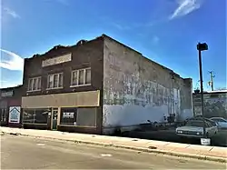 Yingling Brothers Auto Company |
July 5, 2011 (#11000409) |
411 S. Main St. 37°48′51″N 96°51′01″W |
El Dorado | Roadside Kansas MPS |
See also
| Wikimedia Commons has media related to National Register of Historic Places in Butler County, Kansas. |
References
- The latitude and longitude information provided in this table was derived originally from the National Register Information System, which has been found to be fairly accurate for about 99% of listings. Some locations in this table may have been corrected to current GPS standards.
- "National Register of Historic Places: Weekly List Actions". National Park Service, United States Department of the Interior. Retrieved on February 5, 2021.
- Numbers represent an alphabetical ordering by significant words. Various colorings, defined here, differentiate National Historic Landmarks and historic districts from other NRHP buildings, structures, sites or objects.
- "National Register Information System". National Register of Historic Places. National Park Service. March 13, 2009.
- The eight-digit number below each date is the number assigned to each location in the National Register Information System database, which can be viewed by clicking the number.

Municipalities and communities of Butler County, Kansas, United States | ||
|---|---|---|
| Cities | Map of Kansas highlighting Butler County | |
| Unincorporated communities | ||
| Ghost towns | ||
| Townships | ||
| Footnotes | †This populated place is designated a Census-Designated Place (CDP) by the United States Census Bureau, ‡This populated place also has portions in an adjacent county or counties. | |
| ||
This article is issued from Wikipedia. The text is licensed under Creative Commons - Attribution - Sharealike. Additional terms may apply for the media files.