National Register of Historic Places listings in McPherson County, Kansas
This is a list of the National Register of Historic Places listings in McPherson County, Kansas.
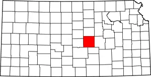
Location of McPherson County in Kansas
This is intended to be a complete list of the properties and districts on the National Register of Historic Places in McPherson County, Kansas, United States. The locations of National Register properties and districts for which the latitude and longitude coordinates are included below, may be seen in a map.[1]
There are 24 properties and districts listed on the National Register in the county.
- This National Park Service list is complete through NPS recent listings posted January 29, 2021.[2]
Current listings
| [3] | Name on the Register[4] | Image | Date listed[5] | Location | City or town | Description |
|---|---|---|---|---|---|---|
| 1 | Berquist & Nelson Drugstore Building | April 22, 2009 (#09000228) |
105 N. Main St. 38°34′25″N 97°40′33″W |
Lindsborg | ||
| 2 | Canton Township Carnegie Library | 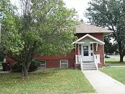 Canton Township Carnegie Library |
June 25, 1987 (#87000960) |
300 N. Main 38°23′17″N 97°25′35″W |
Canton | |
| 3 | Rosberg-Holmgren-Clareen Block | April 22, 2009 (#09000229) |
109-111-113 N. Main St. 38°34′25″N 97°40′33″W |
Lindsborg | Formerly listed as the Clareen-Peterson Restaurant Building; expanded and renamed October 11, 2016 | |
| 4 | Farmers State Bank |  Farmers State Bank |
October 16, 2008 (#08000985) |
101 S. Main St. 38°34′24″N 97°40′33″W |
Lindsborg | |
| 5 | Hans Hanson House | 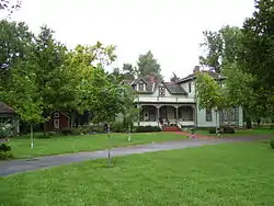 Hans Hanson House |
February 19, 1982 (#82002665) |
211 E. 5th St. 38°33′24″N 97°49′54″W |
Marquette | |
| 6 | Hjerpe Grocery | July 11, 2010 (#10000447) |
110 & 112 N. Main St. 38°34′26″N 97°40′31″W |
Lindsborg | ||
| 7 | Holmberg and Johnson Blacksmith Shop | April 22, 2009 (#09000230) |
122 N. Main St. 38°34′26″N 97°40′33″W |
Lindsborg | ||
| 8 | Inman I.O.O.F. Hall | April 15, 2011 (#11000195) |
100 N. Main. 38°13′55″N 97°46′32″W |
Inman | ||
| 9 | Johnson House | March 19, 1998 (#98000251) |
226 W. Lincoln 38°34′51″N 97°40′43″W |
Lindsborg | ||
| 10 | Kuns-Collier House | March 8, 2006 (#06000114) |
302 S. Walnut St. 38°22′01″N 97°40′10″W |
McPherson | ||
| 11 | P.J. Lindquist Building | June 8, 2015 (#15000318) |
116 S. Main St. 38°34′22″N 97°40′33″W |
Lindsborg | ||
| 12 | McPherson Community Building | June 29, 2018 (#100002628) |
122 E. Marlin St. 38°22′13″N 97°39′57″W |
McPherson | ||
| 13 | McPherson County Courthouse | 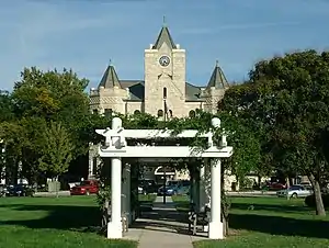 McPherson County Courthouse |
November 21, 1976 (#76002264) |
Maple and Kansas Aves. 38°22′12″N 97°40′07″W |
McPherson | |
| 14 | McPherson Opera House |  McPherson Opera House |
March 16, 1972 (#72001452) |
221 S. Main St. 38°22′02″N 97°39′59″W |
McPherson | |
| 15 | North Gypsum Creek Truss Leg Bedstead Bridge | May 9, 2003 (#03000367) |
Sioux Rd., 0.2 miles east of intersection with 24th Ave., 1.0 mile south and 2.8 miles west of Roxbury 38°32′12″N 97°28′39″W |
Roxbury | ||
| 16 | Paint Creek Archeological Site | June 20, 1972 (#72001449) |
Western bank of Paint Creek, 1.5 miles (2.4 km) south of its confluence with the Smoky Hill River[6] 38°30′05″N 97°42′55″W |
Lindsborg | Formerly known as the Salina 1 Site[7] | |
| 17 | Power Plant No. 1 | October 10, 2007 (#07001067) |
414 W. Elizabeth St. 38°22′06″N 97°40′16″W |
McPherson | ||
| 18 | Heinrich H. Schroeder Barn | September 21, 2005 (#05001051) |
632 29th Ave. 38°16′03″N 97°23′18″W |
Canton | ||
| 19 | Sharps Creek Archeological Site | June 22, 1972 (#72001450) |
Eastern side of Sharps Creek, 1.5 miles (2.4 km) above its confluence with the Smoky Hill River[8] 38°30′25″N 97°45′42″W |
Lindsborg | ||
| 20 | Smoky Valley Roller Mill |  Smoky Valley Roller Mill |
February 23, 1972 (#72001451) |
Mill St. 38°34′39″N 97°40′39″W |
Lindsborg | |
| 21 | Swedish Pavilion | 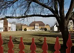 Swedish Pavilion |
March 20, 1973 (#73002129) |
Mill St. 38°34′02″N 97°40′27″W |
Lindsborg | |
| 22 | Teichgraeber-Runbeck House | November 15, 2005 (#05001239) |
116 Mill St. 38°33′57″N 97°40′29″W |
Lindsborg | ||
| 23 | US Post Office-Lindsborg | October 17, 1989 (#89001646) |
125 E. Lincoln St. 38°34′27″N 97°39′50″W |
Lindsborg | ||
| 24 | John R. Wright House | May 2, 2002 (#02000427) |
322 W. Marlin St. 38°22′14″N 97°40′13″W |
McPherson |
See also
| Wikimedia Commons has media related to National Register of Historic Places in McPherson County, Kansas. |
References
- The latitude and longitude information provided in this table was derived originally from the National Register Information System, which has been found to be fairly accurate for about 99% of listings. Some locations in this table may have been corrected to current GPS standards.
- "National Register of Historic Places: Weekly List Actions". National Park Service, United States Department of the Interior. Retrieved on January 29, 2021.
- Numbers represent an alphabetical ordering by significant words. Various colorings, defined here, differentiate National Historic Landmarks and historic districts from other NRHP buildings, structures, sites or objects.
- "National Register Information System". National Register of Historic Places. National Park Service. March 13, 2009.
- The eight-digit number below each date is the number assigned to each location in the National Register Information System database, which can be viewed by clicking the number.
- Wedel, Waldo. "Salina 1: A Protohistoric Village Site in McPherson County, Kansas". Nebraska History Magazine 15.3 (1934): 239-251: 239.
- Roper, Donna C. "The Whiteford Family of Salina". Kansas History 25.4 (2002): 244-257: 247.
- Wedel, Waldo. "The Council Circles of Central Kansas: Were They Solstice Registers?" American Antiquity 32.1 (1967): 54-63: 55.

Municipalities and communities of McPherson County, Kansas, United States | ||
|---|---|---|
| Cities | Map of Kansas highlighting McPherson County | |
| Unincorporated communities | ||
| Townships |
| |
| Footnotes | †This populated place is designated a Census-Designated Place (CDP) by the United States Census Bureau | |
| ||
This article is issued from Wikipedia. The text is licensed under Creative Commons - Attribution - Sharealike. Additional terms may apply for the media files.