National Register of Historic Places listings in Bourbon County, Kansas
This is a list of the National Register of Historic Places listings in Bourbon County, Kansas.
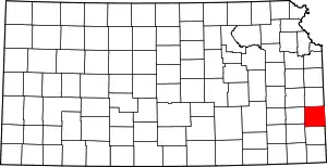
Location of Bourbon County in Kansas
This is intended to be a complete list of the properties and districts on the National Register of Historic Places in Bourbon County, Kansas, United States. The locations of National Register properties and districts for which the latitude and longitude coordinates are included below, may be seen in a map.[1]
There are 12 properties and districts listed on the National Register in the county.
- This National Park Service list is complete through NPS recent listings posted February 5, 2021.[2]
Current listings
| [3] | Name on the Register[4] | Image | Date listed[5] | Location | City or town | Description |
|---|---|---|---|---|---|---|
| 1 | First Congregational Church | 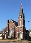 First Congregational Church |
March 23, 2005 (#05000200) |
502 S. National Ave. 37°50′11″N 94°42′27″W |
Fort Scott | |
| 2 | First Presbyterian Church | 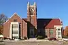 First Presbyterian Church |
July 2, 2008 (#08000619) |
308 S. Crawford St. 37°50′19″N 94°42′36″W |
Fort Scott | |
| 3 | Fort Scott Downtown Historic District | 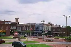 Fort Scott Downtown Historic District |
December 18, 2009 (#09001091) |
Oak to 3rd St. and Scott Ave. to National Ave. 37°50′27″N 94°42′22″W |
Fort Scott | |
| 4 | Fort Scott National Cemetery | Fort Scott National Cemetery |
July 15, 1999 (#99000835) |
900 East National Ave. 37°49′18″N 94°41′36″W |
Fort Scott | |
| 5 | Fort Scott National Historic Site | 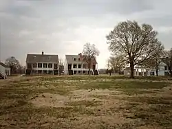 Fort Scott National Historic Site |
October 15, 1966 (#66000106) |
Old Fort Boulevard 37°50′38″N 94°42′17″W |
Fort Scott | |
| 6 | Fort Scott Public Carnegie Library | 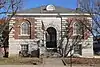 Fort Scott Public Carnegie Library |
August 18, 1987 (#87000930) |
201 S. National 37°50′23″N 94°42′25″W |
Fort Scott | |
| 7 | Fulton High School and Grade School | Fulton High School and Grade School |
October 5, 2015 (#15000688) |
408 W. Osage St. 38°00′35″N 94°43′16″W |
Fulton | |
| 8 | Long Shoals Bridge | 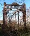 Long Shoals Bridge |
January 4, 1990 (#89002182) |
Over the Little Osage River east of Fulton 37°59′41″N 94°37′18″W |
Fulton | Metal Truss Bridges in Kansas 1861--1939 MPS apporoved for move 7/18/2012 |
| 9 | Marmaton Bridge | May 11, 1982 (#82002652) |
1 mile northeast of Fort Scott 37°51′33″N 94°40′14″W |
Fort Scott | ||
| 10 | Moody Building |  Moody Building |
November 9, 1977 (#77000570) |
15 E. 2nd St. 37°50′24″N 94°42′23″W |
Fort Scott | |
| 11 | Union Block | 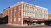 Union Block |
April 26, 1972 (#72000489) |
24 S. Main St. 37°50′28″N 94°42′23″W |
Fort Scott | |
| 12 | Eugene Ware Elementary School | 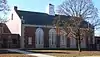 Eugene Ware Elementary School |
June 9, 2005 (#05000552) |
900 E. 3rd St. 37°50′18″N 94°41′49″W |
Fort Scott |
See also
| Wikimedia Commons has media related to National Register of Historic Places in Bourbon County, Kansas. |
References
- The latitude and longitude information provided in this table was derived originally from the National Register Information System, which has been found to be fairly accurate for about 99% of listings. Some locations in this table may have been corrected to current GPS standards.
- "National Register of Historic Places: Weekly List Actions". National Park Service, United States Department of the Interior. Retrieved on February 5, 2021.
- Numbers represent an alphabetical ordering by significant words. Various colorings, defined here, differentiate National Historic Landmarks and historic districts from other NRHP buildings, structures, sites or objects.
- "National Register Information System". National Register of Historic Places. National Park Service. March 13, 2009.
- The eight-digit number below each date is the number assigned to each location in the National Register Information System database, which can be viewed by clicking the number.

Municipalities and communities of Bourbon County, Kansas, United States | ||
|---|---|---|
| Cities | Map of Kansas highlighting Bourbon County | |
| Unincorporated communities | ||
| Townships | ||
| ||
This article is issued from Wikipedia. The text is licensed under Creative Commons - Attribution - Sharealike. Additional terms may apply for the media files.