National Register of Historic Places listings in Linn County, Kansas
This is a list of the National Register of Historic Places listings in Linn County, Kansas.
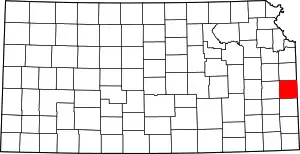
Location of Linn County in Kansas
This is intended to be a complete list of the properties on the National Register of Historic Places in Linn County, Kansas, United States. The locations of National Register properties for which the latitude and longitude coordinates are included below, may be seen in a map.[1]
There are 8 properties listed on the National Register in the county, one of which is a National Historic Landmark.
- This National Park Service list is complete through NPS recent listings posted January 29, 2021.[2]
Current listings
| [3] | Name on the Register[4] | Image | Date listed[5] | Location | City or town | Description |
|---|---|---|---|---|---|---|
| 1 | Battle of Mine Creek Site | December 12, 1973 (#73000762) |
2.5 miles southwest of Pleasanton off U.S. Route 69 38°08′06″N 94°43′28″W |
Pleasanton | ||
| 2 | Landers Creek Bridge | 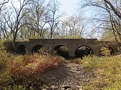 Landers Creek Bridge |
July 2, 1985 (#85001430) |
Southern edge of Goodrich 38°16′50″N 94°59′30″W |
Goodrich | |
| 3 | Linn County Courthouse | 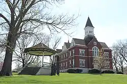 Linn County Courthouse |
July 15, 1974 (#74000842) |
4th and Main 38°08′31″N 94°48′37″W |
Mound City | |
| 4 | Marais des Cygnes Massacre Site | 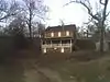 Marais des Cygnes Massacre Site |
June 21, 1971 (#71000317) |
5 miles northeast of Trading Post 38°16′52″N 94°37′12″W |
Trading Post | Includes the Hadsell House, built after the massacre; now a state historic site. |
| 5 | Mine Creek Bridge | 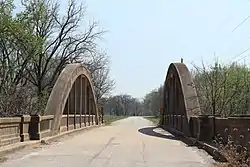 Mine Creek Bridge |
March 10, 1983 (#83000430) |
East of Mound City 38°08′29″N 94°41′42″W |
Mound City | |
| 6 | Old Linn County Jail | November 30, 1978 (#78001285) |
312 Main St. 38°08′34″N 94°48′37″W |
Mound City | ||
| 7 | Prescott School | May 6, 1982 (#82002664) |
3rd and Main Sts. 38°03′55″N 94°41′55″W |
Prescott | ||
| 8 | Prescott Rural High School | July 3, 2008 (#08000610) |
202 West 4th St. 38°03′54″N 94°41′59″W |
Prescott | part of the Public Schools of Kansas Multiple Property Submission |
See also
| Wikimedia Commons has media related to National Register of Historic Places in Linn County, Kansas. |
References
- The latitude and longitude information provided in this table was derived originally from the National Register Information System, which has been found to be fairly accurate for about 99% of listings. Some locations in this table may have been corrected to current GPS standards.
- "National Register of Historic Places: Weekly List Actions". National Park Service, United States Department of the Interior. Retrieved on January 29, 2021.
- Numbers represent an alphabetical ordering by significant words. Various colorings, defined here, differentiate National Historic Landmarks and historic districts from other NRHP buildings, structures, sites or objects.
- "National Register Information System". National Register of Historic Places. National Park Service. March 13, 2009.
- The eight-digit number below each date is the number assigned to each location in the National Register Information System database, which can be viewed by clicking the number.

Municipalities and communities of Linn County, Kansas, United States | ||
|---|---|---|
| Cities | Map of Kansas highlighting Linn County | |
| Unincorporated communities | ||
| Ghost town | ||
| ||
This article is issued from Wikipedia. The text is licensed under Creative Commons - Attribution - Sharealike. Additional terms may apply for the media files.