National Register of Historic Places listings in Ford County, Kansas
This is a list of the National Register of Historic Places listings in Ford County, Kansas.
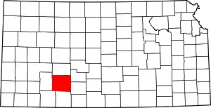
Location of Ford County in Kansas
This is intended to be a complete list of the properties on the National Register of Historic Places in Ford County, Kansas, United States. The locations of National Register properties for which the latitude and longitude coordinates are included below, may be seen in a map.[1]
There are 13 properties listed on the National Register in the county.
- This National Park Service list is complete through NPS recent listings posted February 5, 2021.[2]
Current listings
| [3] | Name on the Register[4] | Image | Date listed[5] | Location | City or town | Description |
|---|---|---|---|---|---|---|
| 1 | Atchison, Topeka and Santa Fe Railway Depot | 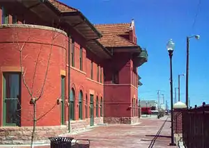 Atchison, Topeka and Santa Fe Railway Depot |
July 14, 2000 (#00000791) |
E. Wyatt Earp Boulevard 37°45′20″N 100°00′46″W |
Dodge City | |
| 2 | Burr House | 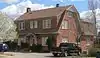 Burr House |
January 31, 2008 (#07001481) |
603 W. Spruce 37°45′16″N 100°01′22″W |
Dodge City | |
| 3 | Dodge City Downtown Historic District | 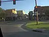 Dodge City Downtown Historic District |
November 4, 2009 (#09000875) |
Roughly bounded by Front St. on the south, 3rd Ave. on the west, Vine St. on the north, and Central Ave. on the east 37°45′14″N 100°01′07″W |
Dodge City | |
| 4 | Dodge City Municipal Building | 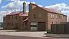 Dodge City Municipal Building |
May 1, 2013 (#13000217) |
501 W. Spruce St. 37°45′16″N 100°01′19″W |
Dodge City | |
| 5 | Dodge City Public Library | 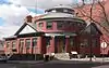 Dodge City Public Library |
March 26, 1979 (#79000954) |
2nd and Spruce Aves. 37°45′17″N 100°01′10″W |
Dodge City | |
| 6 | Hennessy Hall, Saint Mary of the Plains Campus | _W_end_from_S_2.JPG.webp) Hennessy Hall, Saint Mary of the Plains Campus |
January 14, 2004 (#03001396) |
240 San Jose Dr. 37°46′35″N 100°00′39″W |
Dodge City | |
| 7 | Immaculate Heart of Mary Catholic Church | 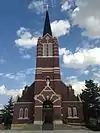 Immaculate Heart of Mary Catholic Church |
January 5, 1989 (#88003087) |
Southeast of Spearville 37°47′06″N 99°38′28″W |
Windthorst | |
| 8 | Lora Locke Hotel | 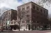 Lora Locke Hotel |
January 3, 1985 (#85000012) |
Central and Gunsmoke Sts. 37°45′13″N 100°01′02″W |
Dodge City | |
| 9 | Mueller-Schmidt House | 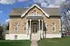 Mueller-Schmidt House |
February 23, 1972 (#72000499) |
112 E. Vine St. 37°45′20″N 100°00′56″W |
Dodge City | |
| 10 | Sacred Heart Cathedral | _from_SE_1.JPG.webp) Sacred Heart Cathedral |
February 10, 1983 (#83000426) |
903 Central Ave. 37°45′23″N 100°01′01″W |
Dodge City | |
| 11 | Santa Fe Trail-Ford County Segment 2 | 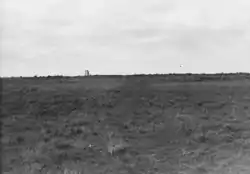 Santa Fe Trail-Ford County Segment 2 |
July 17, 2013 (#13000488) |
SW. corner of Ridge & 129th Rds. 37°39′33″N 99°41′48″W |
Ford | Santa Fe Trail Multiple Property Submission |
| 12 | Sante Fe Trail Ruts | 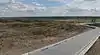 Sante Fe Trail Ruts |
October 15, 1966 (#66000343) |
9 miles west of Dodge City on U.S. Route 50 37°47′31″N 100°11′49″W |
Dodge City | |
| 13 | Sawlog Creek Crossing on the Fort Hayes-Fort Dodge Road | July 17, 2013 (#13000489) |
Address Restricted |
Spearville | Santa Fe Trail Multiple Property Submission |
See also
| Wikimedia Commons has media related to National Register of Historic Places in Ford County, Kansas. |
References
- The latitude and longitude information provided in this table was derived originally from the National Register Information System, which has been found to be fairly accurate for about 99% of listings. Some locations in this table may have been corrected to current GPS standards.
- "National Register of Historic Places: Weekly List Actions". National Park Service, United States Department of the Interior. Retrieved on February 5, 2021.
- Numbers represent an alphabetical ordering by significant words. Various colorings, defined here, differentiate National Historic Landmarks and historic districts from other NRHP buildings, structures, sites or objects.
- "National Register Information System". National Register of Historic Places. National Park Service. March 13, 2009.
- The eight-digit number below each date is the number assigned to each location in the National Register Information System database, which can be viewed by clicking the number.

Municipalities and communities of Ford County, Kansas, United States | ||
|---|---|---|
| Cities | Map of Kansas highlighting Ford County | |
| Unincorporated communities | ||
| Townships | ||
| Footnotes | †This populated place is designated a Census-Designated Place (CDP) by the United States Census Bureau | |
| ||
This article is issued from Wikipedia. The text is licensed under Creative Commons - Attribution - Sharealike. Additional terms may apply for the media files.