National Register of Historic Places listings in Kingman County, Kansas
This is a list of the National Register of Historic Places listings in Kingman County, Kansas.
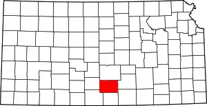
Location of Kingman County in Kansas
This is intended to be a complete list of the properties on the National Register of Historic Places in Kingman County, Kansas, United States. The locations of National Register properties for which the latitude and longitude coordinates are included below, may be seen in a map.[1]
There are 8 properties listed on the National Register in the county.
- This National Park Service list is complete through NPS recent listings posted January 29, 2021.[2]
Current listings
| [3] | Name on the Register[4] | Image | Date listed[5] | Location | City or town | Description |
|---|---|---|---|---|---|---|
| 1 | Kingman Carnegie Library | 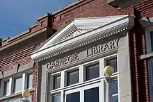 Kingman Carnegie Library |
June 25, 1987 (#87000955) |
455 N. Main 37°38′45″N 98°06′47″W |
Kingman | |
| 2 | Kingman City Building | 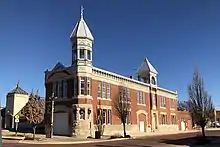 Kingman City Building |
April 13, 1972 (#72000506) |
Main St. and C Ave. 37°38′43″N 98°06′45″W |
Kingman | Built in 1888, housed the city offices, jail, and fire house. Architects, Proudfoot & Bird of Wichita. |
| 3 | Kingman County Courthouse | 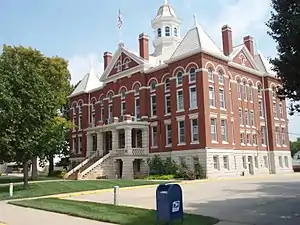 Kingman County Courthouse |
September 11, 1985 (#85002128) |
120 Spruce St. 37°38′34″N 98°06′40″W |
Kingman | |
| 4 | Kingman National Guard Armory | 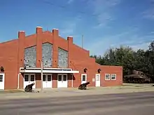 Kingman National Guard Armory |
July 7, 2004 (#04000666) |
111 S. Main St. 37°38′26″N 98°06′49″W |
Kingman | |
| 5 | Kingman Santa Fe Depot | 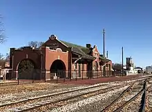 Kingman Santa Fe Depot |
October 11, 2001 (#01001091) |
201 East Sherman 37°38′30″N 98°06′41″W |
Kingman | Built in 1911, the railroad tracks parallel Sherman Street, the brick structure is Mission Revival with a tile roof. |
| 6 | Charles M. Prather Barn | October 31, 2002 (#02001263) |
NW 30th St. and NW 60th Ave. 37°41′22″N 98°13′42″W |
Kingman | ||
| 7 | US Post Office-Kingman | 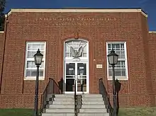 US Post Office-Kingman |
October 17, 1989 (#89001645) |
425 N. Main St. 37°38′44″N 98°06′46″W |
Kingman | |
| 8 | Louis Werner Barn | December 22, 2020 (#100005952) |
4550 NE 80th Ave. 37°42′46″N 97°58′21″W |
Pretty Prairie |
Former listing
| [3] | Name on the Register | Image | Date listed | Date removed | Location | City or town | Summary |
|---|---|---|---|---|---|---|---|
| 1 | Doney-Clark House | May 6, 1994 (#94000409) | January 8, 2014 | 817 W. Sherman St. 37°38′31″N 98°06′47″W |
Kingman | Demolished in 2003[6] |
See also
| Wikimedia Commons has media related to National Register of Historic Places in Kingman County, Kansas. |
References
- The latitude and longitude information provided in this table was derived originally from the National Register Information System, which has been found to be fairly accurate for about 99% of listings. Some locations in this table may have been corrected to current GPS standards.
- "National Register of Historic Places: Weekly List Actions". National Park Service, United States Department of the Interior. Retrieved on January 29, 2021.
- Numbers represent an alphabetical ordering by significant words. Various colorings, defined here, differentiate National Historic Landmarks and historic districts from other NRHP buildings, structures, sites or objects.
- "National Register Information System". National Register of Historic Places. National Park Service. March 13, 2009.
- The eight-digit number below each date is the number assigned to each location in the National Register Information System database, which can be viewed by clicking the number.
- http://www.kshs.org/preserve/pdfs/015_Doney-Clark_House_NR-delisting.pdf

Municipalities and communities of Kingman County, Kansas, United States | ||
|---|---|---|
| Cities | Map of Kansas highlighting Kingman County | |
| Unincorporated communities | ||
| Townships | ||
| ||
This article is issued from Wikipedia. The text is licensed under Creative Commons - Attribution - Sharealike. Additional terms may apply for the media files.