National Register of Historic Places listings in Dickinson County, Kansas
This is a list of the National Register of Historic Places listings in Dickinson County, Kansas.
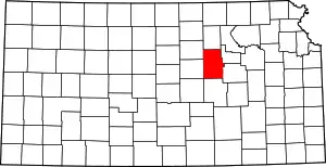
Location of Dickinson County in Kansas
This is intended to be a complete list of the properties and districts on the National Register of Historic Places in Dickinson County, Kansas, United States. Latitude and longitude coordinates are provided for many National Register properties and districts; these locations may be seen together in a map.[1]
There are 44 properties and districts listed on the National Register in the county, including 1 National Historic Landmark. Another 4 properties were once listed but have been removed.
- This National Park Service list is complete through NPS recent listings posted February 5, 2021.[2]
Current listings
| [3] | Name on the Register[4] | Image | Date listed[5] | Location | City or town | Description |
|---|---|---|---|---|---|---|
| 1 | Abilene City Park Historic District | June 6, 2002 (#02000608) |
4th St. at Poplar St. and Pine St. 38°55′10″N 97°13′38″W |
Abilene | ||
| 2 | Abilene Downtown Historic District | September 1, 2009 (#09000673) |
Roughly bounded by Northeast 4th, West 1st, South Walnut, and North Olive Street 38°55′02″N 97°12′51″W |
Abilene | ||
| 3 | Abilene Historic District No. 1 | .jpg.webp) Abilene Historic District No. 1 |
January 11, 2006 (#05001514) |
301, 303, 305, 307, and 309 N. Buckeye 38°55′02″N 97°12′48″W |
Abilene | |
| 4 | Abilene Union Pacific Railroad Freight Depot | .jpg.webp) Abilene Union Pacific Railroad Freight Depot |
September 2, 1993 (#93000894) |
110 N. Cedar St. 38°54′58″N 97°13′01″W |
Abilene | |
| 5 | Abilene Union Pacific Railroad Passenger Depot | September 8, 1992 (#92001175) |
Junction of N. 2nd St. and Broadway 38°54′59″N 97°12′54″W |
Abilene | ||
| 6 | ATSF Steam Locomotive No. 3415 | 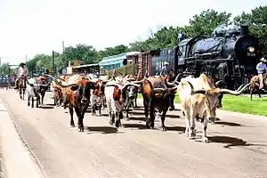 ATSF Steam Locomotive No. 3415 |
April 16, 2012 (#12000203) |
411 S. Elm St. 38°54′49″N 97°13′18″W |
Abilene | |
| 7 | Berger House | June 27, 2007 (#07000606) |
208 NE 12th St. 38°55′37″N 97°12′40″W |
Abilene | ||
| 8 | John W. Birchmore House | April 7, 2014 (#14000116) |
1204 N. Buckeye Ave. 38°55′39″N 97°12′53″W |
Abilene | ||
| 9 | Brewer Scout Cabin | July 18, 2000 (#00000770) |
Solomon City Park, 100 E. 4th St. 38°55′03″N 97°22′13″W |
Solomon | ||
| 10 | Chapman Creek Pratt Truss Bridge | May 9, 2003 (#03000375) |
Quail Rd., 1.7 miles (2.7 km) south of intersection with Highway 18, 2.5 miles (4.0 km) north of Chapman 39°00′31″N 97°02′12″W |
Chapman | ||
| 11 | Emerson Coulson House | .jpg.webp) Emerson Coulson House |
April 14, 1995 (#95000444) |
813 N. Olive St. 38°55′24″N 97°12′35″W |
Abilene | |
| 12 | Eisenhower Home | 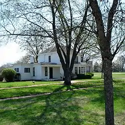 Eisenhower Home |
January 25, 1971 (#71000306) |
201 SE 4th St. 38°54′45″N 97°12′42″W |
Abilene | |
| 13 | Eliason Barn | April 8, 2009 (#09000189) |
174 Highway 4 38°41′00″N 97°21′46″W |
Holland Township | Agriculture-Related Resources of Kansas MPS | |
| 14 | Elms Hotel | .jpg.webp) Elms Hotel |
July 10, 2008 (#08000644) |
201 W. 1st St. 38°54′55″N 97°12′53″W |
Abilene | |
| 15 | Jacob S. Engle House | January 11, 2017 (#100000506) |
102 Highland Dr. 38°55′45″N 97°12′52″W |
Abilene | ||
| 16 | Freeman-Zumbrunn House | November 14, 2002 (#02001266) |
3052 Quail Rd. 39°02′04″N 97°02′09″W |
Chapman | ||
| 17 | Garfield Elementary School | November 4, 2009 (#09000874) |
300 NW 7th St. 38°55′18″N 97°12′56″W |
Abilene | ||
| 18 | David R. Gordon House | July 3, 2012 (#12000384) |
400 N. Cedar St. 38°55′07″N 97°13′01″W |
Abilene | ||
| 19 | Herington Carnegie Public Library | June 25, 1987 (#87000953) |
102 S. Broadway 38°40′05″N 96°56′30″W |
Herington | ||
| 20 | Hoffman and Lamb Buildings | January 11, 2017 (#100000510) |
102-104 S. Factory St. 38°54′18″N 97°07′02″W |
Enterprise | ||
| 21 | J.S. Hollinger Farmstead | July 8, 2010 (#10000448) |
2250 2100 Ave. 38°53′46″N 96°58′23″W |
Chapman | ||
| 22 | Hotel Sunflower | 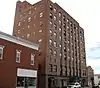 Hotel Sunflower |
May 25, 2001 (#01000539) |
409 NW 3rd St. 38°54′59″N 97°13′01″W |
Abilene | |
| 23 | John Johntz House | 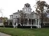 John Johntz House |
September 20, 1991 (#91001437) |
214 N. Walnut 38°55′05″N 97°13′10″W |
Abilene | |
| 24 | Gustave A. Kubach House | October 9, 2013 (#13000815) |
101 S. Buckeye Ave. 38°54′54″N 97°12′51″W |
Abilene | ||
| 25 | Lander Park Carousel | .jpg.webp) Lander Park Carousel |
February 27, 1987 (#87000813) |
412 S. Campbell St. 38°54′41″N 97°12′31″W |
Abilene | |
| 26 | C.H. Lebold House | 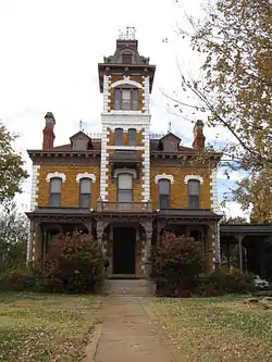 C.H. Lebold House |
May 8, 1973 (#73000751) |
106 N. Vine St. 38°54′56″N 97°13′24″W |
Abilene | |
| 27 | Litts-Dieter House | July 14, 2000 (#00000789) |
702 North Cedar 38°55′19″N 97°12′59″W |
Abilene | ||
| 28 | Mead-Rogers House | 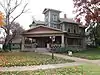 Mead-Rogers House |
July 14, 2000 (#00000790) |
813 NW 3rd St. 38°55′01″N 97°13′28″W |
Abilene | |
| 29 | Naroma Court Historic District | November 28, 2007 (#07001224) |
800 N. Buckeye; 801, 803, 805 Spruceway; 106 Naroma Ct. 38°55′21″N 97°12′52″W |
Abilene | ||
| 30 | Perring Building | .jpg.webp) Perring Building |
December 31, 1998 (#98001561) |
115 NW 3rd and 118 NW 2nd Sts. 38°55′05″N 97°12′52″W |
Abilene | |
| 31 | Prospect Park Farm | February 19, 1982 (#82002654) |
Southeast of Chapman 38°52′52″N 96°59′09″W |
Chapman | ||
| 32 | Rock Island Depot | 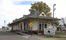 Rock Island Depot |
April 12, 2010 (#10000177) |
200 SE Fifth St. 38°54′38″N 97°12′43″W |
Abilene | |
| 33 | St. John's Episcopal Church | .jpg.webp) St. John's Episcopal Church |
May 25, 2001 (#01000537) |
519 N. Buckeye Ave. 38°55′12″N 97°12′47″W |
Abilene | |
| 34 | A. B. Seelye House | April 25, 1986 (#86000859) |
1105 N. Buckeye 38°55′36″N 97°12′45″W |
Abilene | ||
| 35 | D.G. Smith Building | .jpg.webp) D.G. Smith Building |
August 31, 1995 (#95001053) |
217 W. 1st St. 38°54′53″N 97°13′04″W |
Abilene | |
| 36 | Smoky Hill Trail and Butterfield Overland Despatch Segment | July 7, 2015 (#15000381) |
522 Golf Course Rd. 38°58′16″N 97°02′08″W |
Chapman | ||
| 37 | Staatz House | February 4, 2005 (#04001426) |
1824 Wolf Rd. 38°51′41″N 96°55′34″W |
Junction City | ||
| 38 | Trinity Evangelical Lutheran Church | November 1, 2006 (#06000965) |
320 N. Cedar St. 38°55′05″N 97°13′00″W |
Abilene | ||
| 39 | United Building | .jpg.webp) United Building |
May 25, 2001 (#01000538) |
300 N. Cedar St. 38°55′03″N 97°13′00″W |
Abilene | |
| 40 | US Post Office-Herington | October 17, 1989 (#89001641) |
17 E. Main St. 38°40′11″N 96°56′29″W |
Herington | ||
| 41 | Versteeg-Swisher House | March 23, 2005 (#05000201) |
506 S. Campbell 38°54′36″N 97°12′14″W |
Abilene | ||
| 42 | Vine Street Historic District | July 2, 2018 (#100002622) |
301 to 415 N Vine & 808-810 NW 3rd Sts. 38°55′03″N 97°13′24″W |
Abilene | ||
| 43 | Wheatland Farm Historic District | January 28, 2004 (#03001494) |
2291 2100 Ave. 38°53′36″N 96°57′55″W |
Chapman | ||
| 44 | Wilson Pratt Truss Bridge | January 22, 2009 (#08001349) |
2.9 miles (4.7 km) west of Rain Rd. on 3200 Ave. 39°03′38″N 97°04′21″W |
Chapman |
Former listings
| [3] | Name on the Register | Image | Date listed | Date removed | Location | City or town | Summary |
|---|---|---|---|---|---|---|---|
| 1 | First Presbyterian Church of Abilene | May 25, 2001 (#01000540) | January 7, 2015 | 300 N. Mulberry St. 38°55′04″N 97°13′05″W |
Abilene | Destroyed by fire on July 23, 2014.[6] | |
| 2 | Old Belle Springs Creamery and Produce Building | April 12, 1982 (#82002653) | February 5, 1999 | Court and Cottage Sts. |
Abilene | ||
| 3 | St. Patrick's Mission Church and School | June 26, 1987 (#87000983) | May 6, 2009 | Northeast of Chapman 38°58′51″N 97°00′26″W |
Chapman | Destroyed by a tornado June 11, 2008.[7] | |
| 4 | Union Pacific Railroad Depot | April 26, 1972 (#72000491) | Unknown | 3rd St. between Walnut and Pine Sts. |
Solomon |
See also
| Wikimedia Commons has media related to National Register of Historic Places in Dickinson County, Kansas. |
References
- The latitude and longitude information provided in this table was derived originally from the National Register Information System, which has been found to be fairly accurate for about 99% of listings. Some locations in this table may have been corrected to current GPS standards.
- "National Register of Historic Places: Weekly List Actions". National Park Service, United States Department of the Interior. Retrieved on February 5, 2021.
- Numbers represent an alphabetical ordering by significant words. Various colorings, defined here, differentiate National Historic Landmarks and historic districts from other NRHP buildings, structures, sites or objects.
- "National Register Information System". National Register of Historic Places. National Park Service. March 13, 2009.
- The eight-digit number below each date is the number assigned to each location in the National Register Information System database, which can be viewed by clicking the number.
- Abilene loses a treasure when fire destroys historic Great Plains Theatre; The Wichita Eagle; July 31, 2014.
- Kansas State Historical Society

Municipalities and communities of Dickinson County, Kansas, United States | ||
|---|---|---|
| Cities | Map of Kansas highlighting Dickinson County | |
| Unincorporated communities | ||
| Townships | ||
| Footnotes | †This populated place is designated a Census-Designated Place (CDP) by the United States Census Bureau, ‡This populated place also has portions in an adjacent county or counties. | |
| ||
This article is issued from Wikipedia. The text is licensed under Creative Commons - Attribution - Sharealike. Additional terms may apply for the media files.