National Register of Historic Places listings in Cowley County, Kansas
This is a list of the National Register of Historic Places listings in Cowley County, Kansas.
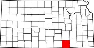
Location of Cowley County in Kansas
This is intended to be a complete list of the properties and districts on the National Register of Historic Places in Cowley County, Kansas, United States. The locations of National Register properties and districts for which the latitude and longitude coordinates are included below, may be seen in a map.[1]
There are 23 properties and districts listed on the National Register in the county. Another 2 properties were once listed, but have since been removed.
- This National Park Service list is complete through NPS recent listings posted January 29, 2021.[2]
Current listings
| [3] | Name on the Register[4] | Image | Date listed[5] | Location | City or town | Description |
|---|---|---|---|---|---|---|
| 1 | Arkansas City Commercial Historic District | 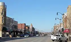 Arkansas City Commercial Historic District |
October 28, 1983 (#83003599) |
Summit St. and 5th Ave. 37°03′39″N 97°02′21″W |
Arkansas City | |
| 2 | Arkansas City Country Club Site | August 25, 1978 (#78001277) |
Eastern side of the Walnut River, on the Arkansas City Country Club[6] 37°04′27″N 97°00′46″W |
Creswell Township | ||
| 3 | Bryant School | October 4, 2017 (#100001701) |
1011 Mansfield St. 37°14′19″N 97°00′04″W |
Winfield | ||
| 4 | Bucher Bridge | 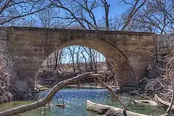 Bucher Bridge |
July 2, 1985 (#85001420) |
Off U.S. Route 77 37°27′45″N 97°02′19″W |
Rock | The Bucher bridge over Eight Mile Creek northwest of Rock, Kansas is 44 feet long and 13 feet wide. Completed in 1905 by Walter Sharp of El Dorado and constructed of solid concrete. |
| 5 | W. H. Coffin House | 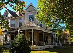 W. H. Coffin House |
August 28, 2003 (#03000839) |
421 E. 11th Ave. 37°14′18″N 96°59′30″W |
Winfield | Built in 1892, the W. H. Coffin House is an example of Queen Anne style architecture in the United States popular from about 1880 to 1900. |
| 6 | Cowley County National Bank Building | 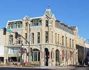 Cowley County National Bank Building |
August 11, 1983 (#83000421) |
820-822 Main St. 37°14′25″N 96°59′47″W |
Winfield | Completed in 1886 and first occupied as the Farmers’ Bank. From 1891 until 1922, it was operated at the Cowley County National Bank. The building was designed in the style of Second Empire architecture by local architects by W. A. Ritchie and W.J. Ritchie. |
| 7 | East Badger Creek Culvert | 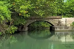 East Badger Creek Culvert |
December 29, 2015 (#15000936) |
182nd Rd. approx. .3 mi. E. of 131st Rd. 37°12′55″N 96°54′33″W |
Winfield | |
| 8 | Esch's Spur Bridge | 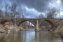 Esch's Spur Bridge |
July 2, 1985 (#85001423) |
3 miles south and 3 miles west of Dexter 37°08′07″N 96°46′52″W |
Dexter | |
| 9 | Grace Methodist Episcopal Church | .JPG.webp) Grace Methodist Episcopal Church |
November 15, 2005 (#05001241) |
320 College St. 37°14′48″N 96°58′39″W |
Winfield | |
| 10 | W. P. Hackney House | 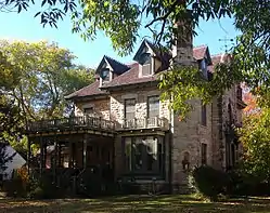 W. P. Hackney House |
March 7, 1973 (#73000749) |
417 E. 10th St. 37°14′21″N 96°59′31″W |
Winfield | Completed in 1886, the three-story limestone house is an example of Vernacular architecture. It was home to W. P. Hackney, a prominent lawyer and politician. |
| 11 | Magnolia Ranch | March 7, 1973 (#73000750) |
10 miles southeast of Winfield on U.S. Route 77 37°08′03″N 96°55′23″W |
Winfield | ||
| 12 | Old Arkansas City High School | 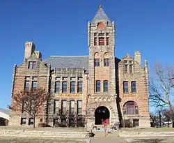 Old Arkansas City High School |
November 21, 1974 (#74000824) |
300 W. Central St. 37°03′45″N 97°02′29″W |
Arkansas City | Now used by Cowley Community College. |
| 13 | Pettit Cleaners Building | 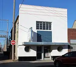 Pettit Cleaners Building |
January 5, 2005 (#04001427) |
114 E. 8th Ave. 37°14′29″N 96°59′45″W |
Winfield | |
| 14 | Pilgrim Congregational Church | .JPG.webp) Pilgrim Congregational Church |
June 8, 2005 (#05000545) |
101 N. Third St. 37°03′45″N 97°02′33″W |
Arkansas City | |
| 15 | St. John's Lutheran College-Baden Hall | 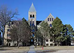 St. John's Lutheran College-Baden Hall |
January 18, 2011 (#10001138) |
Seventh Ave. and College St. 37°14′34″N 96°58′42″W |
Winfield | |
| 16 | St. John's Lutheran College Girls Dormitory | 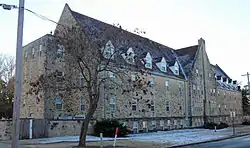 St. John's Lutheran College Girls Dormitory |
January 28, 2002 (#01001544) |
6th Ave. and Gary St. 37°14′36″N 96°58′51″W |
Winfield | |
| 17 | Silver Creek Bridge | 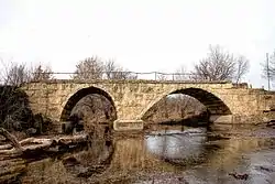 Silver Creek Bridge |
January 30, 1987 (#86003270) |
East of Winfield 37°12′03″N 96°50′34″W |
Winfield | |
| 18 | Strother Field Tetrahedron Wind Indicator | April 14, 2015 (#15000143) |
22215 Tupper St. (Strother Field) 37°10′09″N 97°02′17″W |
Winfield | ||
| 19 | Weigle Barn | October 11, 2016 (#16000702) |
14097 189th Rd. 37°17′02″N 96°48′41″W |
Burden | ||
| 20 | West Dormitory-St. John's College | 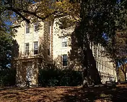 West Dormitory-St. John's College |
December 13, 1991 (#91001769) |
1415 E. Sixth Ave. 37°13′50″N 96°46′38″W |
Winfield | Rehwinkel Hall, originally known as the West Dormitory, was completed in 1916 as a three-story building with raised basement, facing south on the former St. John's College (Kansas) campus. |
| 21 | Wilmer House | 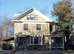 Wilmer House |
January 31, 2008 (#07001477) |
1310 E. 9th Ave. 37°14′27″N 96°58′52″W |
Winfield | |
| 22 | Winfield National Bank Building | 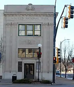 Winfield National Bank Building |
January 20, 2012 (#11001031) |
901 Main St. 37°14′25″N 96°59′51″W |
Winfield | |
| 23 | Winfield Public Carnegie Library | 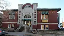 Winfield Public Carnegie Library |
January 11, 1988 (#87002230) |
1001 Millington St. 37°14′19″N 96°59′47″W |
Winfield |
Former listings
| [3] | Name on the Register | Image | Date listed | Date removed | Location | City or town | Summary |
|---|---|---|---|---|---|---|---|
| 1 | Gladstone Hotel | August 26, 1983 (#83000422) | February 25, 2004 | N. Summit Street |
Arkansas City | ||
| 2 | George W. Yount Barn |  George W. Yount Barn |
May 16, 1997 (#97000436) | December 29, 2015 | 1 mile east of U.S. Route 77, approximately 2.5 miles north of Winfield 37°16′49″N 96°59′12″W |
Winfield |
See also
| Wikimedia Commons has media related to National Register of Historic Places in Cowley County, Kansas. |
References
- The latitude and longitude information provided in this table was derived originally from the National Register Information System, which has been found to be fairly accurate for about 99% of listings. Some locations in this table may have been corrected to current GPS standards.
- "National Register of Historic Places: Weekly List Actions". National Park Service, United States Department of the Interior. Retrieved on January 29, 2021.
- Numbers represent an alphabetical ordering by significant words. Various colorings, defined here, differentiate National Historic Landmarks and historic districts from other NRHP buildings, structures, sites or objects.
- "National Register Information System". National Register of Historic Places. National Park Service. March 13, 2009.
- The eight-digit number below each date is the number assigned to each location in the National Register Information System database, which can be viewed by clicking the number.
- Location derived from its NRHP nomination form; the NRIS lists the site as "Address Restricted"

Municipalities and communities of Cowley County, Kansas, United States | ||
|---|---|---|
| Cities | Map of Kansas highlighting Cowley County | |
| Unincorporated communities | ||
| Townships | ||
| Footnotes | ‡This populated place also has portions in an adjacent county or counties | |
| ||
This article is issued from Wikipedia. The text is licensed under Creative Commons - Attribution - Sharealike. Additional terms may apply for the media files.