National Register of Historic Places listings in Saline County, Kansas
This is a list of the National Register of Historic Places listings in Saline County, Kansas.
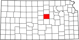
Location of Saline County in Kansas
This is intended to be a complete list of the properties and districts on the National Register of Historic Places in Saline County, Kansas, United States. The locations of National Register properties and districts for which the latitude and longitude coordinates are included below, may be seen in a map.[1]
There are 18 properties and districts listed on the National Register in the county, including 1 National Historic Landmark. At least one other site that was once listed has been removed.
- This National Park Service list is complete through NPS recent listings posted February 5, 2021.[2]
Current listings
| [3] | Name on the Register[4] | Image | Date listed[5] | Location | City or town | Description |
|---|---|---|---|---|---|---|
| 1 | Brookville Grade School | 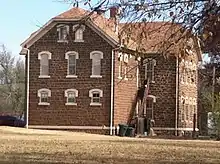 Brookville Grade School |
November 2, 1982 (#82000419) |
Jewitt and Anderson Sts. 38°46′23″N 97°52′13″W |
Brookville | |
| 2 | Christ Cathedral | .jpg.webp) Christ Cathedral |
July 6, 2010 (#10000429) |
138 South 8th St. 38°50′21″N 97°36′43″W |
Salina | |
| 3 | Coronado Heights | 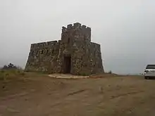 Coronado Heights |
October 20, 2010 (#10000847) |
12th and Coronado Heights Rd. 38°36′48″N 97°42′12″W |
Lindsborg | New Deal-Era Resources of Kansas MPS |
| 4 | Flanders-Lee House and Carriage House | Flanders-Lee House and Carriage House |
August 20, 1987 (#87001406) |
200 S. 7th St. 38°50′17″N 97°36′38″W |
Salina | |
| 5 | Fox-Watson Theater Building | 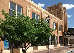 Fox-Watson Theater Building |
August 4, 1988 (#88001171) |
155 S. Santa Fe Ave. 38°50′17″N 97°36′32″W |
Salina | |
| 6 | Hobbs Creek Truss Leg Bedstead Bridge | October 12, 2004 (#04001143) |
On Hobbs Creek Rd., 0.6 miles west of its junction with Solomon Rd. 38°38′17″N 97°22′59″W |
Gypsum | ||
| 7 | Lakewood Park Bridge | 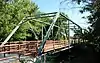 Lakewood Park Bridge |
June 9, 2004 (#04000579) |
One Lakewood Dr., 0.01 miles north of its junction with Iron Ave. 38°50′28″N 97°35′22″W |
Salina | |
| 8 | H.D. Lee Company Complex | July 3, 2008 (#08000618) |
248 N. Santa Fe 38°50′38″N 97°36′34″W |
Salina | ||
| 9 | Lowell School | October 2, 2020 (#100005625) |
1009 South Highland Ave. 38°49′09″N 97°36′41″W |
Salina | ||
| 10 | Masonic Temple | 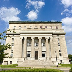 Masonic Temple |
March 9, 2000 (#00000192) |
336 S. Santa Fe Ave. 38°50′05″N 97°36′33″W |
Salina | |
| 11 | Mount Barbara | April 14, 1995 (#95000445) |
100 Mt. Barbara 38°50′23″N 97°34′51″W |
Salina | ||
| 12 | National Bank of America | August 24, 2020 (#100004923) |
100 South Santa Fe Ave. 38°50′25″N 97°36′33″W |
Salina | ||
| 13 | The Norton Apartments | March 26, 2018 (#100002246) |
1111 & 1115 E Iron Ave. 38°50′26″N 97°35′36″W |
Salina | ||
| 14 | John H. Prescott House |  John H. Prescott House |
May 17, 1976 (#76000838) |
211 W. Prescott Ave. 38°49′48″N 97°36′40″W |
Salina | |
| 15 | Roosevelt-Lincoln Junior High School | 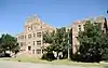 Roosevelt-Lincoln Junior High School |
December 20, 2006 (#06001169) |
210 W. Mulberry St. 38°50′22″N 97°37′00″W |
Salina | |
| 16 | A.J. Schwartz House | 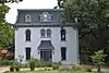 A.J. Schwartz House |
April 13, 1973 (#73000774) |
636 E. Iron St. 38°50′25″N 97°36′04″W |
Salina | |
| 17 | US Post Office and Federal Building-Salina | US Post Office and Federal Building-Salina |
July 18, 1989 (#89000793) |
211 W. Iron 38°50′25″N 97°36′40″W |
Salina | |
| 18 | Whiteford (Price) Archeological Site |  Whiteford (Price) Archeological Site |
October 15, 1966 (#66000350) |
East of Salina 38°51′39″N 97°31′36″W |
Salina |
Former listings
| [3] | Name on the Register | Image | Date listed | Date removed | Location | City or town | Summary |
|---|---|---|---|---|---|---|---|
| 1 | Brookville Hotel | January 7, 1972 (#72000525) | January 2, 2013 | Perry St. 38°46′23″N 97°52′01″W |
Brookville | Removed due to significant alterations. |
See also
| Wikimedia Commons has media related to National Register of Historic Places in Saline County, Kansas. |
References
- The latitude and longitude information provided in this table was derived originally from the National Register Information System, which has been found to be fairly accurate for about 99% of listings. Some locations in this table may have been corrected to current GPS standards.
- "National Register of Historic Places: Weekly List Actions". National Park Service, United States Department of the Interior. Retrieved on February 5, 2021.
- Numbers represent an alphabetical ordering by significant words. Various colorings, defined here, differentiate National Historic Landmarks and historic districts from other NRHP buildings, structures, sites or objects.
- "National Register Information System". National Register of Historic Places. National Park Service. March 13, 2009.
- The eight-digit number below each date is the number assigned to each location in the National Register Information System database, which can be viewed by clicking the number.

Municipalities and communities of Saline County, Kansas, United States | ||
|---|---|---|
| Cities | Map of Kansas highlighting Saline County | |
| Unincorporated communities | ||
| Townships |
| |
| Footnotes | †This populated place is designated a Census-Designated Place (CDP) by the United States Census Bureau, ‡This populated place also has portions in an adjacent county or counties. | |
| ||
This article is issued from Wikipedia. The text is licensed under Creative Commons - Attribution - Sharealike. Additional terms may apply for the media files.