National Register of Historic Places listings in Sumner County, Kansas
This is a list of the National Register of Historic Places listings in Sumner County, Kansas.
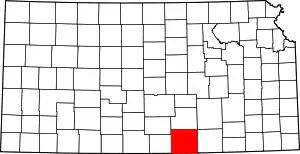
Location of Sumner County in Kansas
This is intended to be a complete list of the properties and districts on the National Register of Historic Places in Sumner County, Kansas, United States. The locations of National Register properties and districts for which the latitude and longitude coordinates are included below, may be seen in a map.[1]
There are 10 properties and districts listed on the National Register in the county, and one former listing.
- This National Park Service list is complete through NPS recent listings posted February 5, 2021.[2]
Current listings
| [3] | Name on the Register[4] | Image | Date listed[5] | Location | City or town | Description |
|---|---|---|---|---|---|---|
| 1 | Bartlett Arboretum | .JPG.webp) Bartlett Arboretum |
April 19, 2010 (#10000180) |
Southwest corner of Highway 55 and Line St. 37°23′33″N 97°17′06″W |
Belle Plaine | |
| 2 | Buresh Archeological Site | May 14, 1971 (#71000333) |
Address restricted |
Caldwell | ||
| 3 | Caldwell Carnegie Library | 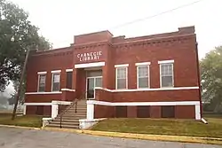 Caldwell Carnegie Library |
February 24, 1983 (#83000443) |
13 N. Osage St. 37°01′58″N 97°36′34″W |
Caldwell | |
| 4 | Downtown Wellington Historic District | June 27, 2007 (#07000600) |
Roughly bounded by 10th St., 4th St., Jefferson Ave., and the alley behind the Washington Ave. facing buildings 37°16′00″N 97°23′55″W |
Wellington | ||
| 5 | Old Oxford Mill | 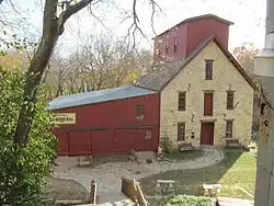 Old Oxford Mill |
April 26, 1982 (#82002677) |
Northeast of Oxford 37°17′40″N 97°09′30″W |
Oxford | |
| 6 | Salter House | 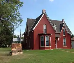 Salter House |
September 3, 1971 (#71000332) |
220 W. Garfield St. 37°15′53″N 97°46′00″W |
Argonia | Home of first woman mayor in the United States, elected in 1887. |
| 7 | Edwin Smith House | 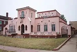 Edwin Smith House |
May 19, 2004 (#04000450) |
114 S. Jefferson 37°15′54″N 97°23′58″W |
Wellington | |
| 8 | H.F. Smith House | 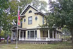 H.F. Smith House |
April 18, 2007 (#07000318) |
721 W. Harvey Ave. 37°15′57″N 97°24′23″W |
Wellington | |
| 9 | US Post Office-Caldwell | 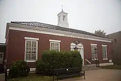 US Post Office-Caldwell |
October 17, 1989 (#89001635) |
14 N. Main St. 37°01′58″N 97°36′31″W |
Caldwell | |
| 10 | Wellington Carnegie Library | 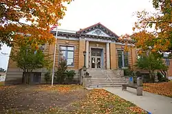 Wellington Carnegie Library |
June 25, 1987 (#87000973) |
121 W. 7th 37°16′03″N 97°23′56″W |
Wellington |
Former listings
| [3] | Name on the Register | Image | Date listed | Date removed | Location | City or town | Summary |
|---|---|---|---|---|---|---|---|
| 1 | Spring Creek School | May 9, 1997 (#97000410) | January 13, 2017 | 4 miles north of U.S. Route 81, approximately 4 miles northeast of Caldwell 37°05′17″N 97°31′40″W |
Corbin |
See also
| Wikimedia Commons has media related to National Register of Historic Places in Sumner County, Kansas. |
References
- The latitude and longitude information provided in this table was derived originally from the National Register Information System, which has been found to be fairly accurate for about 99% of listings. Some locations in this table may have been corrected to current GPS standards.
- "National Register of Historic Places: Weekly List Actions". National Park Service, United States Department of the Interior. Retrieved on February 5, 2021.
- Numbers represent an alphabetical ordering by significant words. Various colorings, defined here, differentiate National Historic Landmarks and historic districts from other NRHP buildings, structures, sites or objects.
- "National Register Information System". National Register of Historic Places. National Park Service. March 13, 2009.
- The eight-digit number below each date is the number assigned to each location in the National Register Information System database, which can be viewed by clicking the number.

Municipalities and communities of Sumner County, Kansas, United States | ||
|---|---|---|
| Cities | Map of Kansas highlighting Sumner County | |
| Unincorporated communities | ||
| Ghost towns |
| |
| Footnotes | †This populated place is designated a Census-Designated Place (CDP) by the United States Census Bureau, ‡This populated place also has portions in an adjacent county or counties. | |
| ||
This article is issued from Wikipedia. The text is licensed under Creative Commons - Attribution - Sharealike. Additional terms may apply for the media files.