National Register of Historic Places listings in Nemaha County, Kansas
This is a list of the National Register of Historic Places listings in Nemaha County, Kansas.
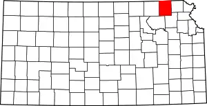
Location of Nemaha County in Kansas
This is intended to be a complete list of the properties and districts on the National Register of Historic Places in Nemaha County, Kansas, United States. The locations of National Register properties and districts for which the latitude and longitude coordinates are included below, may be seen in a map.[1]
There are 11 properties and districts listed on the National Register in the county.
- This National Park Service list is complete through NPS recent listings posted February 5, 2021.[2]
Current listings
| [3] | Name on the Register[4] | Image | Date listed[5] | Location | City or town | Description |
|---|---|---|---|---|---|---|
| 1 | Clear Creek Camel Truss Bridge | May 9, 2003 (#03000360) |
Unnamed road, 0.5 miles west of FAS 485 and 6.8 miles north of Baileyville 39°56′22″N 96°11′33″W |
Baileyville | ||
| 2 | Hand-Dug City Water Well | 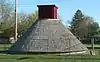 Hand-Dug City Water Well |
March 15, 2007 (#07000141) |
301 N. 11th St. 39°50′16″N 96°04′14″W |
Seneca | |
| 3 | Lake Nemaha Dam Guardrail | July 2, 2008 (#08000620) |
5.12 miles south of Seneca on K-63 39°45′56″N 96°02′06″W |
Seneca | ||
| 4 | Marion Hall | April 25, 2001 (#01000411) |
Junction of Main and 1st Sts. 39°50′34″N 96°10′27″W |
Baileyville | ||
| 5 | Nemaha County Jail and Sheriff's House | 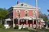 Nemaha County Jail and Sheriff's House |
May 19, 2004 (#04000455) |
113 N. 6th St. 39°50′10″N 96°03′50″W |
Seneca | |
| 6 | Old Albany Schoolhouse | 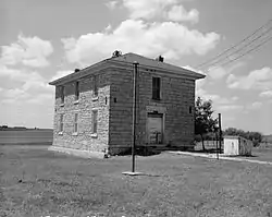 Old Albany Schoolhouse |
April 13, 1972 (#72000518) |
2 miles north of Sabetha 39°56′32″N 95°48′16″W |
Berwick Township | |
| 7 | Prairie Grove School | March 8, 2006 (#06000113) |
Township Road H southeast of its intersection with Township Road 232 39°59′04″N 96°06′32″W |
Seneca | ||
| 8 | St. Mary's Church | December 5, 1980 (#80001470) |
9208 Main Street 39°53′08″N 96°05′53″W |
St. Benedict | ||
| 9 | Seneca Main Street Historic District | 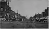 Seneca Main Street Historic District |
September 7, 2006 (#06000770) |
301-607 Main, 304-612 Main, 25 N. 6th, and 26 N. 4th 39°50′03″N 96°03′46″W |
Seneca | |
| 10 | US Post Office-Sabetha | 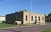 US Post Office-Sabetha |
October 17, 1989 (#89001650) |
122 S. 9th St. 39°54′10″N 95°48′04″W |
Sabetha | |
| 11 | US Post Office-Seneca | October 17, 1989 (#89001651) |
607 Main St. 39°50′04″N 96°03′53″W |
Seneca |
See also
| Wikimedia Commons has media related to National Register of Historic Places in Nemaha County, Kansas. |
References
- The latitude and longitude information provided in this table was derived originally from the National Register Information System, which has been found to be fairly accurate for about 99% of listings. Some locations in this table may have been corrected to current GPS standards.
- "National Register of Historic Places: Weekly List Actions". National Park Service, United States Department of the Interior. Retrieved on February 5, 2021.
- Numbers represent an alphabetical ordering by significant words. Various colorings, defined here, differentiate National Historic Landmarks and historic districts from other NRHP buildings, structures, sites or objects.
- "National Register Information System". National Register of Historic Places. National Park Service. March 13, 2009.
- The eight-digit number below each date is the number assigned to each location in the National Register Information System database, which can be viewed by clicking the number.

Municipalities and communities of Nemaha County, Kansas, United States | ||
|---|---|---|
| Cities | Map of Kansas highlighting Nemaha County | |
| Unincorporated communities | ||
| Footnotes | †This populated place is designated a Census-Designated Place (CDP) by the United States Census Bureau, ‡This populated place also has portions in an adjacent county or counties. | |
| ||
This article is issued from Wikipedia. The text is licensed under Creative Commons - Attribution - Sharealike. Additional terms may apply for the media files.