National Register of Historic Places listings in Brown County, Kansas
This is a list of the National Register of Historic Places listings in Brown County, Kansas.
Location of Brown County in Kansas
This is intended to be a complete list of the properties and districts on the National Register of Historic Places in Brown County, Kansas, United States. The locations of National Register properties and districts for which the latitude and longitude coordinates are included below, may be seen in a map.[1]
There are 14 properties and districts listed on the National Register in the county.
- This National Park Service list is complete through NPS recent listings posted February 5, 2021.[2]
Current listings
| [3] | Name on the Register[4] | Image | Date listed[5] | Location | City or town | Description |
|---|---|---|---|---|---|---|
| 1 | Bethany Brethren Church | _from_NE_1.JPG.webp) Bethany Brethren Church |
October 9, 2012 (#12000843) |
121 1st St. 39°54′55″N 95°37′49″W |
Hamlin | |
| 2 | Samuel Bierer House | 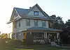 Samuel Bierer House |
July 8, 2010 (#10000450) |
410 North 7th St. 39°51′22″N 95°32′15″W |
Hiawatha | |
| 3 | Davis Memorial | _S_sculptures_7_SE_Sarah.JPG.webp) Davis Memorial |
August 29, 1977 (#77000571) |
0.1 mile east of Hiawatha, Mt. Hope Cemetery 39°50′57″N 95°30′58″W |
Hiawatha | |
| 4 | Delaware River Warren Truss Bridge | 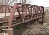 Delaware River Warren Truss Bridge |
June 9, 2004 (#04000580) |
Coyote Rd., 190th St., 4.1 miles south and 0.5 miles east of Fairview 39°46′59″N 95°42′51″W |
Fairview | |
| 5 | A. J. Eicholtz House | 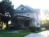 A. J. Eicholtz House |
January 28, 2004 (#03001493) |
406 North 7th St. 39°51′22″N 95°32′15″W |
Hiawatha | |
| 6 | Fete Apartments | July 12, 2019 (#100004202) |
205 E. 7th St. 39°39′32″N 95°31′33″W |
Horton | ||
| 7 | Seward Graham House | .jpg.webp) Seward Graham House |
December 11, 2008 (#08001172) |
115 Miami St. 39°51′22″N 95°31′38″W |
Hiawatha | |
| 8 | Hiawatha Courthouse Square Historic District | .jpg.webp) Hiawatha Courthouse Square Historic District |
August 21, 2006 (#05001052) |
520-819 Oregon, 101-123 S6, 108-124 S7, 601-613 Utah 39°51′09″N 95°32′13″W |
Hiawatha | |
| 9 | Hiawatha Memorial Auditorium | 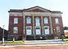 Hiawatha Memorial Auditorium |
September 5, 1985 (#85001978) |
611 Utah St. 39°51′09″N 95°32′10″W |
Hiawatha | |
| 10 | Hiawatha National Guard Armory | Hiawatha National Guard Armory |
July 7, 2004 (#04000667) |
108 N. 1st. St. 39°51′13″N 95°31′39″W |
Hiawatha | |
| 11 | Horton Civic Center | March 26, 2020 (#100005121) |
125 West 7th St. and 145 West 7th St. 39°39′32″N 95°31′45″W |
Horton | ||
| 12 | Iowa Tribe Community Building | June 27, 2016 (#16000404) |
330th Rd. 39°59′15″N 95°22′13″W |
White Cloud | ||
| 13 | Site No. RH00-062 | 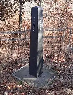 Site No. RH00-062 |
June 19, 1987 (#87001001) |
6½ miles southeast of Rulo, Nebraska and 200 feet west of the road between White Cloud, Kansas and Rulo 40°00′00″N 95°19′55″W |
Iowa Township | Extends into Doniphan County, Kansas and Richardson County, Nebraska |
| 14 | U.S. Post Office – Horton | 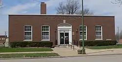 U.S. Post Office – Horton |
October 17, 1989 (#89001643) |
825 1st Ave. E. 39°39′39″N 95°31′34″W |
Horton |
See also
| Wikimedia Commons has media related to National Register of Historic Places in Brown County, Kansas. |
References
- The latitude and longitude information provided in this table was derived originally from the National Register Information System, which has been found to be fairly accurate for about 99% of listings. Some locations in this table may have been corrected to current GPS standards.
- "National Register of Historic Places: Weekly List Actions". National Park Service, United States Department of the Interior. Retrieved on February 5, 2021.
- Numbers represent an alphabetical ordering by significant words. Various colorings, defined here, differentiate National Historic Landmarks and historic districts from other NRHP buildings, structures, sites or objects.
- "National Register Information System". National Register of Historic Places. National Park Service. March 13, 2009.
- The eight-digit number below each date is the number assigned to each location in the National Register Information System database, which can be viewed by clicking the number.

Municipalities and communities of Brown County, Kansas, United States | ||
|---|---|---|
| Cities | Map of Kansas highlighting Brown County | |
| Unincorporated communities | ||
| Indian reservations | ||
| Townships | ||
| Footnotes | †This populated place is designated a Census-Designated Place (CDP) by the United States Census Bureau, ‡This populated place also has portions in an adjacent county or counties. | |
| ||
This article is issued from Wikipedia. The text is licensed under Creative Commons - Attribution - Sharealike. Additional terms may apply for the media files.