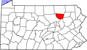
Sullivan County, Pennsylvania
Sullivan County is a county located in the U.S. state of Pennsylvania. As of the 2010 census, the population was 6,428,[1] making it the second-least populous county in Pennsylvania. Its county seat is Laporte.[2] The county was created on March 15, 1847, from part of Lycoming County and named for Charles C. Sullivan, leader of the Pennsylvania Senate at that time.[3]
Sullivan County | |
|---|---|
 | |
 Location within the U.S. state of Pennsylvania | |
 Pennsylvania's location within the U.S. | |
| Coordinates: 41°27′N 76°31′W | |
| Country | |
| State | |
| Founded | March 15, 1847 |
| Named for | Charles C. Sullivan |
| Seat | Laporte |
| Largest borough | Dushore |
| Area | |
| • Total | 452 sq mi (1,170 km2) |
| • Land | 450 sq mi (1,200 km2) |
| • Water | 2.6 sq mi (7 km2) 0.6% |
| Population | |
| • Estimate (2018) | 6,071 |
| • Density | 14/sq mi (5/km2) |
| Time zone | UTC−5 (Eastern) |
| • Summer (DST) | UTC−4 (EDT) |
| Congressional district | 12th |
| Website | www |
History
The land which became Sullivan County was originally purchased from the Iroquois by the Province of Pennsylvania in 1768, as part of the first Treaty of Fort Stanwix. It was then part of Northumberland County, then became part of Lycoming County when it was formed in 1795.[4] Sullivan County itself was formed from the northeastern part of Lycoming County on March 15, 1847. It was the thirteenth and last county formed at least partly from Lycoming County (and the fifth entirely formed from it).[4]
According to the official state publication Pennsylvania Local Government, Sullivan County was named for Pennsylvania state senator Charles C. Sullivan, who "took an active part in procuring passage of the bill" establishing the county.[5] However, according to Frederic A. Godcharles (1933), the county is named for General John Sullivan, who led the Sullivan Expedition against the Iroquois in 1779.[6]
Geography
According to the U.S. Census Bureau, the county has a total area of 452 square miles (1,170 km2), of which 450 square miles (1,200 km2) is land and 2.6 square miles (6.7 km2) (0.6%) is water.[7]
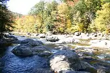
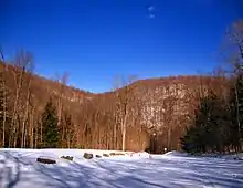
Elevation ranges from 2593 ft at North Mountain in Davidson Township to 779 ft on Loyalsock Creek at the Lycoming County line. The county is served by Pennsylvania Route 42, Pennsylvania Route 87, Pennsylvania Route 154, Pennsylvania Route 487, and U.S. Route 220. The major rivers in the county are Loyalsock Creek, Little Loyalsock Creek, Muncy Creek, and Fishing Creek. The majority of the land in Sullivan County is forest, but there is some farmland, especially in the northern part of the county. There are numerous river valleys in the southern and western parts of Sullivan County.[8]
Sullivan has a warm-summer humid continental climate (Dfb) and average monthly temperatures in Laporte range from 21.8 °F in January to 67.9 °F in July.
Adjacent counties
- Bradford County (north)
- Wyoming County (east)
- Luzerne County (southeast)
- Columbia County (south)
- Lycoming County (west)
Geology
Sullivan County lies predominantly within the Appalachian Plateau physiographic province, which is characterized by gently folded and faulted sedimentary rocks of middle to late Paleozoic age. The southern border of the county is approximately at the Allegheny Front, a geological boundary between the Ridge and Valley province and the plateau. (PA Geologic Survey Map 13). The mountains within the county are part of the Endless Mountains.

The stratigraphic record of sedimentary rocks within the county spans from the Devonian Lock Haven Formation (exposed only in Lick Creek valley) to the coal-bearing Pennsylvanian Allegheny Formation. Generally, the Catskill Formation underlies most of the lowlands, and sandstones of the Huntley Mountain, Burgoon, Mauch Chunk, or Pottsville Formations cap the mountains. No igneous or metamorphic rocks exist within the county, other than possible glacial erratics.
Structurally, the bedrock of Sullivan County is gently folded, with the axes of two major anticlines (including the Wilmot Anticline) and two major synclines (Bernice-Mehoopany Syncline and Noxen Syncline) each trending roughly east–west. There are three mapped faults in the Allegheny Formation between the towns of Murray and Ringdale.[9][10]
Nearly all of Sullivan County was glaciated several times in the past, during the Pleistocene epoch, or "Ice Age." (PA Geologic Survey Map 59). Most of the county is covered by glacial till of Late Wisconsinan age. Late Illinoian Stage deposits may underlie the Late Wisconsinan deposits, and these are exposed in the south central part of the county (roughly western Davidson Township).
The major rivers in Sullivan County are Loyalsock Creek and Muncy Creek. Both flow into the West Branch of the Susquehanna River. Some streams along the eastern border of the county flow into the North Branch of the Susquehanna River. All of Sullivan county is thus within the Chesapeake Bay Watershed.
Several small coal fields exist within Sullivan County.[11] The fields contain either bituminous or semi-anthracite coal, and all occur within Pennsylvanian strata.
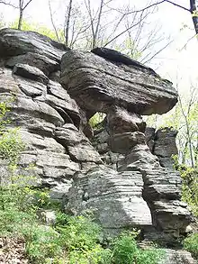
Notable geologic features within Sullivan County include some of the following:
- The Haystacks (Huntley Mountain Formation), exposed along Loyalsock Creek south of Dushore, are sandstone mounds of unknown origin
- Ganoga Lake is the state's highest lake at 2265 ft above sea level
- Ricketts Glen State Park, with its many waterfalls
- Worlds End State Park, including an exposure of the Huntley Mountain Formation, and a "rock city" where cross-bedding is visible in the sandstone of the Pottsville Formation
- The Leberfinger Quarry (on Millview Mountain Rd northeast of Forksville), in the Lock Haven Formation where brachiopod fossils, trace fossils, and plant fossils can be observed[12]
- Grand View, located at the southeast corner of the county on a knob of Red Rock Mountain, provides scenic views of the Allegheny Front
- Ticklish Rock, located near Glen Mawr up Rock Run Road, features a rock formation of the Devonian Catskill Formation.
Mountains
| Name | Height |
| Huckleberry Mountain | 2,496 ft. (762 meters) |
| Roundtop | 2,484 ft. (758 meters) |
| Prospect Hill | 2,140 ft. (653 meters) |
| Tomkins Corners Vista | 2,110 ft. (644 meters) |
| High Knob | 2,025 ft. (618 meters) |
| Bear Mountain | 1,995 ft. (609 meters) |
| Lovers Rock | 1,995 ft. (609 meters) |
| Gooseberry Hill | 1,940 ft. (592 meters) |
| Middle Hill | 1,927 ft. (588 meters) |
| Camp Mountain | 1,920 ft. (586 meters) |
| Hogback Hill | 1,923 ft. (587 meters) |
| Pole Hill | 1,917 ft. (585 meters) |
| Big Hill | 1,897 ft. (579 meters) |
| Browns Vista | 1,819 ft. (554 meters) |
| Lambert Hill | 1,743 (532 meters) |
| Warburton Hill | 1,743 ft. (532 meters) |
| Molyneux Hill | 1,740 ft. (531 meters) |
| Wright Hill | 1,717 ft. (524 meters) |
| Shrimp Hill | 1,661 ft. (507 meters) |
Demographics
| Historical population | |||
|---|---|---|---|
| Census | Pop. | %± | |
| 1850 | 3,694 | — | |
| 1860 | 5,637 | 52.6% | |
| 1870 | 6,191 | 9.8% | |
| 1880 | 8,073 | 30.4% | |
| 1890 | 11,620 | 43.9% | |
| 1900 | 12,134 | 4.4% | |
| 1910 | 11,293 | −6.9% | |
| 1920 | 9,520 | −15.7% | |
| 1930 | 7,499 | −21.2% | |
| 1940 | 7,504 | 0.1% | |
| 1950 | 6,745 | −10.1% | |
| 1960 | 6,251 | −7.3% | |
| 1970 | 5,961 | −4.6% | |
| 1980 | 6,349 | 6.5% | |
| 1990 | 6,104 | −3.9% | |
| 2000 | 6,556 | 7.4% | |
| 2010 | 6,428 | −2.0% | |
| 2018 (est.) | 6,071 | [13] | −5.6% |
| U.S. Decennial Census[14] 1790-1960[15] 1900-1990[16] 1990-2000[17] 2010-2017[1] | |||
As of the census[18] of 2000, there were 6,556 people, 2,660 households, and 1,752 families residing in the county. The population density was 15 people per square mile (6/km2). There were 6,017 housing units at an average density of 13 per square mile (5/km2). The racial makeup of the county was 95.58% White, 2.20% Black or African American, 0.76% Native American, 0.15% Asian, 0.46% from other races, and 0.85% from two or more races. 1.10% of the population were Hispanic or Latino of any race. 33.8% were of German, 14.7% Irish, 9.5% English, 7.5% American, 5.9% Polish and 5.6% Italian ancestry.
There were 2,660 households, out of which 24.20% had children under the age of 18 living with them, 54.70% were married couples living together, 6.80% had a female householder with no husband present, and 34.10% were non-families. 29.30% of all households were made up of individuals, and 15.20% had someone living alone who was 65 years of age or older. The average household size was 2.30 and the average family size was 2.81.
In the county, the population was spread out, with 20.80% under the age of 18, 7.90% from 18 to 24, 24.10% from 25 to 44, 25.30% from 45 to 64, and 21.90% who were 65 years of age or older. The median age was 43 years. For every 100 females there were 102.10 males. For every 100 females age 18 and over, there were 100.40 males.
- County poverty demographics
According to research by The Center for Rural Pennsylvania, which is a legislative Agency of the Pennsylvania General Assembly, the poverty rate for Sullivan County was 14.4% in 2014.[19] The statewide poverty rate was 13.6% in 2014. The 2012 childhood poverty rate by school district was: Area School District - % living at 185% or below than the Federal Poverty Level and Area School District - .[20]
Sullivan County's live birth rate was 55 births in 1990. The County's live birth rate in 2000 was 49 births, while in 2011 it was 55 babies.[21] Over the past 50 years (1960 to 2010), rural Pennsylvania saw a steady decline in both the number and proportion of residents under 18 years old. In 1960, 1.06 million rural residents, or 35 percent of the rural population, were children.
Politics and government
| Year | Republican | Democratic | Third parties |
|---|---|---|---|
| 2020 | 72.8% 2,619 | 25.6% 921 | 1.6% 58 |
| 2016 | 72.7% 2,291 | 23.8% 750 | 3.5% 111 |
| 2012 | 63.3% 1,868 | 35.1% 1,034 | 1.6% 47 |
| 2008 | 58.9% 1,841 | 39.4% 1,233 | 1.7% 52 |
| 2004 | 62.6% 2,056 | 36.9% 1,213 | 0.5% 16 |
| 2000 | 62.1% 1,928 | 34.3% 1,066 | 3.6% 111 |
| 1996 | 47.3% 1,352 | 37.5% 1,071 | 15.2% 435 |
| 1992 | 43.1% 1,340 | 33.1% 1,030 | 23.9% 743 |
| 1988 | 61.9% 1,808 | 37.3% 1,091 | 0.8% 23 |
| 1984 | 66.7% 1,926 | 33.0% 952 | 0.4% 11 |
| 1980 | 57.8% 1,676 | 37.0% 1,074 | 5.2% 152 |
| 1976 | 53.7% 1,584 | 45.7% 1,347 | 0.7% 20 |
| 1972 | 67.2% 1,886 | 31.5% 885 | 1.3% 37 |
| 1968 | 56.8% 1,629 | 36.1% 1,035 | 7.2% 206 |
| 1964 | 44.2% 1,344 | 55.6% 1,690 | 0.1% 4 |
| 1960 | 55.1% 1,808 | 44.8% 1,471 | 0.2% 5 |
| 1956 | 60.9% 2,007 | 39.0% 1,286 | 0.1% 4 |
| 1952 | 61.8% 2,011 | 38.1% 1,239 | 0.1% 3 |
| 1948 | 61.2% 1,752 | 37.9% 1,084 | 0.9% 26 |
| 1944 | 58.2% 1,858 | 41.6% 1,329 | 0.3% 8 |
| 1940 | 55.8% 2,059 | 44.0% 1,626 | 0.2% 7 |
| 1936 | 54.1% 2,121 | 44.4% 1,740 | 1.6% 61 |
| 1932 | 46.8% 1,457 | 51.4% 1,602 | 1.8% 56 |
| 1928 | 64.6% 2,044 | 34.8% 1,101 | 0.5% 17 |
| 1924 | 59.8% 1,668 | 32.7% 913 | 7.5% 210 |
| 1920 | 57.6% 1,620 | 37.7% 1,061 | 4.7% 133 |
| 1916 | 44.0% 888 | 51.3% 1,037 | 4.7% 95 |
| 1912 | 26.5% 547 | 44.1% 912 | 29.4% 608 |
| 1908 | 47.2% 1,119 | 45.4% 1,076 | 7.3% 174 |
| 1904 | 52.0% 1,429 | 43.3% 1,188 | 4.7% 129 |
| 1900 | 45.5% 1,266 | 49.4% 1,376 | 5.1% 143 |
| 1896 | 46.0% 1,215 | 49.2% 1,300 | 4.7% 125 |
| 1892 | 39.1% 873 | 56.7% 1,266 | 4.3% 95 |
| 1888 | 41.0% 946 | 54.6% 1,260 | 4.5% 104 |
As of October 2012, there are 4,243 registered voters in Sullivan County.[23]
- Democratic: 1,612 (37.99%)
- Republican: 2,268 (53.45%)
- Other Parties: 363 (8.56%)
County commissioners
- Brian Hoffman, Chair, Republican
- Donna Iannone, Vice-chair, Democrat
- Darlene Fenton, Republican
Other county offices
- District Attorney, Leonard Simpson, Republican
- Prothonotary, Register of Wills & Recorder of Deeds, Kellie Carpenter, Democrat
- Sheriff, Robert Montgomery, Republican
- Treasurer, Katrina Wilkins, Republican
- Coroner, Wendy Hastings, Republican
State Representative[24]
- Tina Pickett, Republican, 110th district
State Senator[24]
- Gene Yaw, Republican, 23rd district
United States House of Representatives
- Fred Keller, Republican, Pennsylvania's 12th congressional district
United States Senator
- Robert Casey Jr., Democrat
- Pat Toomey, Republican
Education
Public school districts
Sullivan County School District has one high school, grades 7-12, and one elementary school, grades K-6. Sullivan County High School is located in Laporte. Sullivan County Elementary School is located just behind the high school.
School Board Member Tim Nitcznski suggested that LGBTQ+ students were no better than members of the KKK. https://www.pahomepage.com/top-stories/lgbtq-display-dispute-in-sullivan-county/amp/
Transportation
Public transportation is provided by BeST Transit.
Sullivan County is one of only two counties in Pennsylvania with no known active railroad lines of any kind, the other being Fulton County. However, several narrow-gauge logging railroads once served Sullivan County.[25]
Recreation
There are two Pennsylvania state parks in Sullivan County.
- Part of Ricketts Glen State Park is in the eastern portion of the county.
- Worlds End State Park is near Forksville on Loyalsock Creek
There are several festivities held in the county each year. Dushore Founder's Day- Held in August. Activities such as Outhouse Races, Roll-a-Keg Races, Arts and Crafts, and vendors. Dushore Dairy Parade- Held in Mid-June. Activities such as Milking a Cow. Laporte Fireman's Carnival- Held in August. Carnival rides and games. Sullivan County Fair- Held in late August and early September. Carnival rides and games, exhibitions, competitions, Demolition Derby, and vendors.
Sullivan County is also home to a large, private hunting club, Painter Den, Inc.[26] This vast property is situated in Davidson, Laporte and Colley townships. Painter Den pond is also on the property and is stocked with Perch and Pike.
Communities
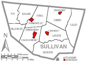
Under Pennsylvania law, there are four types of incorporated municipalities: cities, boroughs, townships, and, in at most two cases, towns. The following boroughs and townships are located in Sullivan County:
Boroughs
- Dushore
- Eagles Mere
- Forksville
- Laporte (county seat)
Townships
Unincorporated communities
- Bedford Corners
- Beech Glen
- Bernice
- Bethel
- Campbellville
- Cherry Mills
- Colley
- Coveytown
- Eagles Mere Park
- Eldredsville
- Elk Grove (partly in Columbia County)
- Elkland Meeting House
- Emmons
- Estella
- Foley Corner
- Hemlock Grove
- Hillsgrove
- Hugos Corner
- Kinsley Corners
- Lincoln Falls
- Long Brook
- Lopez
- Maple Summit
- McCaroll Corner
- Mildred
- Millview
- Muncy Valley
- Murray
- Nordmont
- Ogdonia
- Ricketts
- Ringdale
- Satterfield
- Shinerville
- Shunk
- Sonestown
- Summit
- Tompkins Corners
- Wheelerville
- Wissingers
Population ranking
The population ranking of the following table is based on the 2010 census of Sullivan County.[27]
† county seat
| Rank | City/Town/etc. | Municipal type | Population (2010 Census) |
|---|---|---|---|
| 1 | Dushore | Borough | 608 |
| 2 | Laporte † | Borough | 316 |
| 3 | Forksville | Borough | 145 |
| 4 | Eagles Mere | Borough | 120 |
References
- "State & County QuickFacts". United States Census Bureau. Retrieved November 22, 2013.
- "Find a County". National Association of Counties. Retrieved June 7, 2011.
- "Welcome". sullivancounty-pa.us. Retrieved August 11, 2019.
- Meginness, John Franklin (1892). History of Lycoming County, Pennsylvania: including its aboriginal history; the colonial and revolutionary periods; early settlement and subsequent growth; organization and civil administration; the legal and medical professions; internal improvement; past and present history of Williamsport; manufacturing and lumber interests; religious, educational, and social development; geology and agriculture; military record; sketches of boroughs, townships, and villages; portraits and biographies of pioneers and representative citizens, etc. etc (1st ed.). Chicago, IL: Brown, Runk & Co. ISBN 0-7884-0428-8. Retrieved August 5, 2007.
(Note: ISBN refers to Heritage Books July 1996 reprint. URL is to a scan of the 1892 version with some OCR typos).
- "Pennsylvania Local Government" (PDF). Commonwealth of Pennsylvania. Retrieved 2008-02-07.
- Godcharles, Frederic A. (1933). Pennsylvania: Political, Governmental, Military and Civil: Political and Civil History Volume (First ed.). New York, New York: The American Historical Society.
- "2010 Census Gazetteer Files". United States Census Bureau. August 22, 2012. Retrieved March 10, 2015.
- https://maps.google.com/maps?f=d&source=s_d&saddr=%20Sullivan,%20PA
- PA Geologic Survey Map 61, Overton Quadrangle
- Berg, T.M., Edmunds, W.E., Geyer, A.R. and others, compilers, (1980). Geologic Map of Pennsylvania: Pennsylvania Geologic Survey, Map 1, scale 1:250,000.
- http://www.dcnr.state.pa.us/topogeo/maps/map11.pdf PA Geologic Survey Map 11
- The Haystacks, "Ricketts Folly," and The End of the World: Geology of the Glaciated Allegheny High Plateau, Sullivan, Luzerne, and Columbia Counties, Pennsylvania, 71st Annual Field Conference of Pennsylvania Geologists (field trip guide book), J. D. Inners, G. M. Fleeger, eds., 2006
- "Population and Housing Unit Estimates". Retrieved October 10, 2018.
- "U.S. Decennial Census". United States Census Bureau. Retrieved March 10, 2015.
- "Historical Census Browser". University of Virginia Library. Retrieved March 10, 2015.
- Forstall, Richard L., ed. (March 24, 1995). "Population of Counties by Decennial Census: 1900 to 1990". United States Census Bureau. Retrieved March 10, 2015.
- "Census 2000 PHC-T-4. Ranking Tables for Counties: 1990 and 2000" (PDF). United States Census Bureau. April 2, 2001. Retrieved March 10, 2015.
- "U.S. Census website". United States Census Bureau. Retrieved 2008-01-31.
- US Census Bureau (2015). "Poverty Rates by County Small Area Income and Poverty Estimates".
- Pennsylvania Budget and Policy Center (2012). "Student Poverty Concentration 2012".
- Pennsylvania Department of Health, Birth Age County Reports 1990 and 2011, 2011
- http://uselectionatlas.org/RESULTS
- http://www.dos.state.pa.us/portal/server.pt/community/voter_registration_statistics/12725%7CPA Department of State
- Center, Legislativate Data Processing. "Find Your Legislator". The official website for the Pennsylvania General Assembly. Retrieved 2017-05-12.
- "Penndot Pennsylvania Railroad Map January 2015" (PDF). penndot.gov. Retrieved 5 December 2016.
- http://www.fishingworks.com/lakes/pennsylvania/sullivan/lopez/painter-den-pond/
- https://www.census.gov/2010census/
External links
- Sullivan County Official Website
- Baseline Groundwater Quality from 20 Domestic Wells in Sullivan County, Pennsylvania United States Geological Survey
Municipalities and communities of Sullivan County, Pennsylvania, United States | ||
|---|---|---|
| Boroughs | | |
| Townships | ||
| Unincorporated communities |
| |
| Ghost town | ||
| ||

| Authority control |
|---|