Dungog Shire
Dungog Shire is a local government area in the Hunter region of New South Wales, Australia. The Shire is situated adjacent to the Barrington Tops and consists predominantly of very rugged to hilly country which becomes less rugged from north to south.
| Dungog Shire New South Wales | |||||||||||||||
|---|---|---|---|---|---|---|---|---|---|---|---|---|---|---|---|
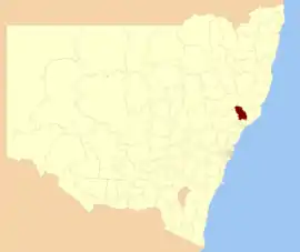 Location in New South Wales | |||||||||||||||
| Coordinates | 32°24′S 151°45′E | ||||||||||||||
| Population | |||||||||||||||
| • Density | 4.08/km2 (10.6/sq mi) | ||||||||||||||
| Established | 1 July 1958 | ||||||||||||||
| Area | 2,251 km2 (869.1 sq mi) | ||||||||||||||
| Time zone | AEST (UTC+10) | ||||||||||||||
| • Summer (DST) | AEDT (UTC+11) | ||||||||||||||
| Mayor | John Connors(independent) | ||||||||||||||
| Council seat | Dungog | ||||||||||||||
| Region | Hunter[3] | ||||||||||||||
| State electorate(s) | Upper Hunter[4] | ||||||||||||||
| Federal Division(s) | Lyne[5] | ||||||||||||||
 | |||||||||||||||
| Website | Dungog Shire | ||||||||||||||
| |||||||||||||||
Dungog Shire was formed on 1 July 1958 through the amalgamation of Wallarobba Shire with the Municipality of Dungog.[6]
The mayor of the Dungog Shire Council is Clr. John Connors, an independent politician.
Main towns/villages
The major population centres within the Shire are Dungog, Gresford, Paterson, Vacy, Martins Creek and Clarence Town. It also includes three main rivers, the Paterson River and Allyn River to the west and the Williams River to the east.
Demographics
At the 2011 census, there were 8,318 people in the Dungog Shire local government area, of these 50.3 per cent were male and 49.7 per cent were female. Aboriginal and Torres Strait Islander people made up 3.2 per cent of the population, which was higher than the national and state averages of 2.5 per cent. The median age of people in the Dungog Shire was 44 years, significantly higher than the national median of 37 years. Children aged 0 – 14 years made up 18.8 per cent of the population and people aged 65 years and over made up 17.6 per cent of the population. Of people in the area aged 15 years and over, 54.7 per cent were married and 11.5 per cent were either divorced or separated.[7]
Population growth in the Dungog Shire between the 2001 census and the 2006 census was 2.37 per cent; and in the subsequent five years to the 2011 census, population growth was 3.18 per cent. When compared with total population growth of Australia for the same periods, being 5.78 per cent and 8.32 per cent respectively, population growth in the Dungog Shire local government area was approximately one-third of the national average.[8][9] The median weekly income for residents within the Dungog Shire was lower than the national average.[7]
At the 2011 census, the proportion of residents in the Dungog Shire local government area who stated their ancestry as Australian or Anglo-Celtic exceeded 85 per cent of all residents (national average was 65.2 per cent). In excess of 56% of all residents in the Dungog Shire nominated a religious affiliation with Christianity at the 2011 census, which was slightly higher than the national average of 50.2 per cent. Meanwhile, as at the census date, compared to the national average, households in the Dungog Shire local government area had a significantly lower than average proportion (2.0 per cent) where two or more languages are spoken (national average was 20.4 per cent); and a significantly higher proportion (95.0 per cent) where English only was spoken at home (national average was 76.8 per cent).[7]
| Selected historical census data for the Dungog Shire local government area | |||||
|---|---|---|---|---|---|
| Census year | 2001[8] | 2006[9] | 2011[7] | ||
| Population | Estimated residents on Census night | 7,875 | 8,062 | 8,318 | |
| LGA rank in terms of size within New South Wales | |||||
| % of New South Wales population | 0.12% | ||||
| % of Australian population | 0.04% | ||||
| Cultural and language diversity | |||||
| Ancestry, top responses | Australian | 35.4% | |||
| English | 33.5% | ||||
| Irish | 8.8% | ||||
| Scottish | 7.6% | ||||
| German | 4.0% | ||||
| Language, top responses (other than English) | German | 0.2% | |||
| Tagalog | 0.1% | ||||
| Italian | 0.1% | ||||
| Afrikaans | 0.1% | ||||
| French | n/c | ||||
| Religious affiliation | |||||
| Religious affiliation, top responses | Anglican | 36.4% | |||
| Catholic | 19.6% | ||||
| No Religion | 11.2% | ||||
| Uniting Church | 7.8% | ||||
| Presbyterian and Reformed | 7.0% | ||||
| Median weekly incomes | |||||
| Personal income | Median weekly personal income | A$385 | A$484 | ||
| % of Australian median income | 82.6% | ||||
| Family income | Median weekly family income | A$1,059 | A$1,278 | ||
| % of Australian median income | 90.4% | ||||
| Household income | Median weekly household income | A$873 | A$1,005 | ||
| % of Australian median income | 85.0% | ||||
Council
Current composition and election method
Dungog Shire Council is composed of nine Councillors elected proportionally in three separate wards, each electing three Councillors. All Councillors are elected for a fixed four-year term of office. The Mayor is elected by the Councillors at the first meeting of the Council. The most recent election was held on 17 September 2017. An election was held in the A, B and C Wards. The makeup of the Council is as follows:[10][11][12]
| Party | Councillors | |
|---|---|---|
| Independents and Unaligned | 9 | |
| Total | 9 | |
The current Council, elected in 2017, by ward, is:
| Ward | Councillor | Party | Notes | |
|---|---|---|---|---|
| A Ward[10] | Tracy Norman | Independent | ||
| John Connors | independent | |||
| Jan Lyon | Independent | |||
| B Ward[11] | Stephen Low AM | Independent | ||
| Digby Rayward | Independent | |||
| Gregory Riley | Independent | |||
| C Ward[12] | Glenn Wall | Independent | ||
| Robert Booth | Independent | |||
| Kathryn Murphy | Independent | |||
Proposed merger
A 2015 review of local government boundaries by the NSW Government Independent Pricing and Regulatory Tribunal recommended that the Dungog Shire merge with adjoining councils. The government considered two proposals. The first proposed a merger of Dungog Shire and Mid-Coast Council councils to form a new council with an area of 5,200 square kilometres (2,000 sq mi) and support a population of approximately 14,000.[13] Following the lodging of an alternate proposal by Mid-Coast Council Council to amalgamate the Gloucester, Great Lakes and Greater Taree councils, the NSW Minister for Local Government proposed a merger between the Dungog Shire and City of Maitland.[14] In response to the government's proposal to merge the Newcastle and Port Stephens local government areas, Port Stephens Council has formally asked the government to evaluate a merger between Port Stephens and Dungog Shire.[15][16][17] Although the Dungog Shire mayor is opposed to this merger, it is reported that the proposal has community support within both local government areas.[17][18] The proposal was debated in the New South Wales parliament on 23 March 2016, with the Minister for Local Government confirming that the proposal had been referred to the Office of Local Government.[19][20]
References
- "3218.0 – Regional Population Growth, Australia, 2014–15". Australian Bureau of Statistics. Retrieved 29 September 2016.
- "3218.0 – Regional Population Growth, Australia, 2017-18". Australian Bureau of Statistics. 27 March 2019. Retrieved 27 March 2019. Estimated resident population (ERP) at 30 June 2018.
- "Suburb Search – Local Council Boundaries – Hunter (HT) – Dungog Shire Council". New South Wales Division of Local Government. Archived from the original on 16 January 2013. Retrieved 3 October 2012.
- "Upper Hunter". New South Wales Electoral Commission. Retrieved 23 November 2019.
- "Lyne". Australian Electoral Commission. 26 July 2012. Archived from the original on 29 October 2009. Retrieved 3 October 2012.
- "Local Government Act 1919. Proclamation (55)". Government Gazette of the State of New South Wales. 30 May 1958. p. 1604. Retrieved 10 January 2020 – via National Library of Australia.
- Australian Bureau of Statistics (31 October 2012). "Dungog (Local Government Area)". 2011 Census QuickStats. Retrieved 10 September 2012.

- Australian Bureau of Statistics (9 March 2006). "Dungog (A)". 2001 Census QuickStats. Retrieved 23 December 2013.
- Australian Bureau of Statistics (25 October 2007). "Dungog (A)". 2006 Census QuickStats. Retrieved 23 December 2013.
- "Dungog Shire Council – A Ward: Summary of First Preference Votes for each Candidate". Local Government Elections 2017. Electoral Commission of New South Wales. 12 September 2012. Retrieved 2 October 2012.
- "Dungog Shire Council – B Ward: Summary of First Preference Votes for each Candidate". Local Government Elections 2012. Electoral Commission of New South Wales. 8 September 2012. Retrieved 2 October 2012.
- "Dungog Shire Council – C Ward: Summary of First Preference Votes for each Candidate". Local Government Elections 2012. Electoral Commission of New South Wales. 12 September 2012. Retrieved 2 October 2012.
- "Merger proposal: Dungog Shire Council, Mid-Coast Council Council" (PDF). Government of New South Wales. January 2016. p. 8. Retrieved 13 March 2016.
- Toole, Paul (March 2016). "Dungog and Maitland councils Proposal" (PDF). Minister for Local Government. Government of New South Wales. Retrieved 8 March 2016.
- "Port Stephens Council Submission" (PDF). Port Stephens Council. 3 March 2016. Retrieved 15 March 2016.
- Norris, Sam (9 March 2016). "Port Stephens requests formal Dungog merger investigation". Port Stephens Examiner. Retrieved 15 March 2016.
- O'Neill, Janelle (13 March 2016). "Merger remark sparks anger". The Maitland Mercury. Retrieved 15 March 2016.
- Fedder, Renee (9 March 2016). "Port Stephens To Pursue Merger With Dungog". NBN News. Retrieved 15 March 2016.
- Wallis, Wayne (22 March 2016). "Port council speaks about proposed Dungog merger". Dungog Chronicle. Retrieved 21 March 2016.
- McGowan, Michael (23 March 2016). "Paul Toole breaks silence on Newcastle and Port Stephens merger in parliament debate". The Newcastle Herald. Retrieved 23 March 2016.