Narromine Shire
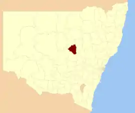
Narromine Shire is a local government area in the Orana region of New South Wales, Australia. The Shire is located adjacent to the Mitchell Highway and the Main Western railway line. It was formed on 1 January 1981 from the amalgamation of the Municipality of Narromine and Timbrebongie Shire resulting from the Local Government Areas Amalgamation Act 1980.[3]
| Narromine Shire New South Wales | |||||||||||||||
|---|---|---|---|---|---|---|---|---|---|---|---|---|---|---|---|
 Location in New South Wales | |||||||||||||||
| Coordinates | 32°14′S 148°14′E | ||||||||||||||
| Population |
| ||||||||||||||
| • Density | 1.22416/km2 (3.1706/sq mi) | ||||||||||||||
| Established | 1 January 1981[3] | ||||||||||||||
| Area | 5,264 km2 (2,032.4 sq mi) | ||||||||||||||
| Mayor | Craig Davies (Independent) | ||||||||||||||
| Council seat | Narromine | ||||||||||||||
| Region | Orana | ||||||||||||||
| State electorate(s) | Dubbo | ||||||||||||||
| Federal Division(s) | Parkes | ||||||||||||||
 | |||||||||||||||
| Website | Narromine Shire | ||||||||||||||
| |||||||||||||||
Narromine Shire includes the towns of Narromine, Trangie and Tomingley.
The Mayor of Narromine Shire Council is Cr. Craig Davies, an independent politician.
Demographics
| Selected historical census data for Narromine Shire local government area | ||||||
|---|---|---|---|---|---|---|
| Census year | 2011[4] | 2016[1] | ||||
| Population | Estimated residents on census night | 6,585 | ||||
| LGA rank in terms of size within New South Wales | 105th | |||||
| % of New South Wales population | ||||||
| % of Australian population | ||||||
| Cultural and language diversity | ||||||
| Ancestry, top responses | English | |||||
| Australian | ||||||
| Italian | ||||||
| Chinese | ||||||
| Irish | ||||||
| Language, top responses (other than English) | Italian | |||||
| Mandarin | ||||||
| Cantonese | ||||||
| Korean | ||||||
| Greek | ||||||
| Religious affiliation | ||||||
| Religious affiliation, top responses | Catholic | |||||
| No religion | ||||||
| Anglican | ||||||
| Eastern Orthodox | ||||||
| Buddhism | ||||||
| Median weekly incomes | ||||||
| Personal income | Median weekly personal income | A$ | ||||
| % of Australian median income | ||||||
| Family income | Median weekly family income | |||||
| % of Australian median income | ||||||
| Household income | Median weekly household income | |||||
| % of Australian median income | ||||||
Council
Current composition and election method
Narromine Shire Council is composed of nine Councillors elected proportionally as a single ward. All Councillors are elected for a fixed four-year term of office. The Mayor is elected by the Councillors at the first meeting of the Council. The most recent election was held on 10 September 2016, and the makeup of the Council is as follows:[5]
| Party | Councillors | |
|---|---|---|
| Independents | 9 | |
| Total | 9 | |
The current Council, elected in 2016, in order of election, is:[5]
| Councillor | Party | Notes | |
|---|---|---|---|
| Rob McCutcheon | Independent | ||
| Craig Davies | Independent | Mayor[6] | |
| James Craft | Independent | ||
| Dawn Collins | Independent | Deputy Mayor[6] | |
| Les Lambert | Independent | ||
| Mark Munro | Independent | ||
| Colin Hamilton | Independent | ||
| Lyn Jablonski | Independent | ||
| Peter Drew | Independent | ||
References
- Australian Bureau of Statistics (27 June 2017). "Narromine (A)". 2016 Census QuickStats. Retrieved 7 July 2017.

- "3218.0 – Regional Population Growth, Australia, 2017-18". Australian Bureau of Statistics. 27 March 2019. Retrieved 27 March 2019. Estimated resident population (ERP) at 30 June 2018.
- Local Government Areas Amalgamation Act 1980 (NSW) Schedule 1.
- Australian Bureau of Statistics (31 October 2012). "Narromine (A)". 2011 Census QuickStats. Retrieved 25 October 2012.

- "Narromine Shire Council: Summary of First Preference Votes for each Candidate". Local Government Elections 2016. Electoral Commission of New South Wales. 17 September 2016. Retrieved 17 October 2016.
- Ryan, Grace (27 September 2016). "New council meets for the first time". Narromine News. Retrieved 17 October 2016.