Wentworth Shire
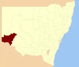
Wentworth Shire is a local government area in the far south-west Riverina region of New South Wales, Australia. This Shire is located adjacent to the Murray and Darling Rivers. The Shire's major roads are the Sturt and the Silver City Highways. The Shire includes the towns of Wentworth, Buronga, Gol Gol, Dareton and Pooncarie.
| Wentworth Shire New South Wales | |||||||||||||||
|---|---|---|---|---|---|---|---|---|---|---|---|---|---|---|---|
 | |||||||||||||||
| Coordinates | 34°05′S 141°54′E | ||||||||||||||
| Population |
| ||||||||||||||
| • Density | 0.26/km2 (0.67/sq mi) | ||||||||||||||
| Established | 23 January 1879[3] | ||||||||||||||
| Area | 26,269 km2 (10,142.5 sq mi) | ||||||||||||||
| Mayor | Melissa Hederics (Independent) | ||||||||||||||
| Council seat | Wentworth | ||||||||||||||
| Region | Far West | ||||||||||||||
| State electorate(s) | Murray | ||||||||||||||
| Federal Division(s) | Farrer | ||||||||||||||
 | |||||||||||||||
| Website | Wentworth Shire | ||||||||||||||
| |||||||||||||||
The Mayor of Wentworth Shire Council is Cr. Melissa Hederics, an Independent politician.
Heritage listings
Wentworth Shire has a number of heritage-listed sites, including:
- Darling River, Polia Station, Pooncarie: PS Rodney[4]
- Wentworth, 112 Beverley Street: Wentworth Gaol[5]
- Wentworth, 30 Caddell Street: St Ignatius School[6]
- Wentworth, Darling Street: St John's Anglican Church, Wentworth[7]
- Wentworth, 1122a Low Darling Road: Avoca Homestead Complex[8]
Council
The area of Wentworth was proclaimed a municipality on 23 January 1879.[3] The first Mayor was Mr. W. Gunn who held office from 1879 to 1880.[9]
Current composition and election method
Wentworth Shire Council is composed of nine Councillors elected proportionally as a single ward. All Councillors are elected for a fixed four-year term of office. The Mayor is elected by the Councillors at the first meeting of the Council. The most recent election was held on 10 September 2016 and the makeup of the Council is as follows:[10]
| Party | Councillors | |
|---|---|---|
| Independents and Unaligned | 9 | |
| Total | 9 | |
The current Council, elected in 2016, in order of election, is:[10]
| Councillor | Party | Notes | |
|---|---|---|---|
| Melissa Hederics | Independent | Mayor[11] | |
| Time Elstone | Independent | Deputy Mayor[11] | |
| Don McKinnon | Unaligned | ||
| Bill Wheeldon | Unaligned | ||
| Greg Evans | Unaligned | ||
| Susan Nichols | Independent | ||
| Jane Macallister | Independent | ||
| Steve Heywood | Independent | ||
| Peter Nunan | Independent | ||
Localities
| Town | Population |
|---|---|
| Arumpo | 34 |
| Buronga | 1,212 |
| Curlwaa | 393 |
| Dareton | 501 |
| Gol Gol | 1,523 |
| Mourquong | 79 |
| Palinyewah | 82 |
| Pomona | 161 |
| Pooncarie | 166 |
| Wentworth | 1,437 |
References
- Australian Bureau of Statistics (27 June 2017). "Wentworth (A)". 2016 Census QuickStats. Retrieved 23 November 2017.

- "3218.0 – Regional Population Growth, Australia, 2017-18". Australian Bureau of Statistics. 27 March 2019. Retrieved 27 March 2019. Estimated resident population (ERP) at 30 June 2018.
- "Wentworth History". Wentworth Shire Council. Retrieved 23 January 2010.
- "Rodney - paddle steamer". New South Wales State Heritage Register. Office of Environment and Heritage. H01776. Retrieved 18 May 2018.
- "Old Wentworth Gaol". New South Wales State Heritage Register. Office of Environment and Heritage. H01982. Retrieved 18 May 2018.
- "St. Ignatius School". New South Wales State Heritage Register. Office of Environment and Heritage. H01507. Retrieved 18 May 2018.
- "St. John's Anglican Church and Rectory". New South Wales State Heritage Register. Office of Environment and Heritage. H00661. Retrieved 18 May 2018.
- "Avoca Homestead Complex". New South Wales State Heritage Register. Office of Environment and Heritage. H01971. Retrieved 18 May 2018.
- "Former Councillors of the Wentworth Shire". Wentworth Shire Council. Retrieved 23 January 2010.
- "Wentworth Shire Council: Summary of First Preference and Group Votes for each Candidate". Local Government Elections 2016. Electoral Commission of New South Wales. 20 September 2016. Retrieved 5 November 2016.
- "Melisa Hederics is elected Mayor of Wentworth Shire Council". Sunraysia Daily. 21 September 2016. Retrieved 4 October 2016.