Bogan Shire
Bogan Shire is a local government area in the Orana region of New South Wales, Australia. The Shire is located adjacent to the Mitchell and Barrier highways and its only significant town is Nyngan.
| Bogan Shire New South Wales | |||||||||||||||
|---|---|---|---|---|---|---|---|---|---|---|---|---|---|---|---|
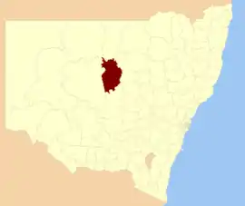 Location in New South Wales | |||||||||||||||
| Coordinates | 31°34′S 147°12′E | ||||||||||||||
| Population |
| ||||||||||||||
| • Density | 0.21/km2 (0.54/sq mi) | ||||||||||||||
| Established | 7 May 1906.[3] | ||||||||||||||
| Area | 14,611 km2 (5,641.3 sq mi) | ||||||||||||||
| Mayor | Ray Donald (Unaligned) | ||||||||||||||
| Council seat | Nyngan[4] | ||||||||||||||
| Region | Orana | ||||||||||||||
| State electorate(s) | Barwon | ||||||||||||||
| Federal Division(s) | Parkes | ||||||||||||||
| Website | Bogan Shire | ||||||||||||||
| |||||||||||||||
The Municipality of Nyngan was proclaimed on 17 February 1891 with Nyngan having a population of 1,355. Bogan Shire was proclaimed on 7 May 1906.[3] Bogan Shire absorbed the Municipality of Nyngan on 1 January 1972.[5]
The Mayor of Bogan Shire Council is Cr. Ray Donald, who is unaligned with any political party.
Demographics
| Selected historical census data for Bogan Shire local government area | ||||||
|---|---|---|---|---|---|---|
| Census year | 2001[6] | 2006[7] | 2011[8] | 2016[1] | ||
| Population | Estimated residents on census night | 3,083 | ||||
| LGA rank in terms of size within New South Wales | 122nd | |||||
| % of New South Wales population | 0.05% | |||||
| % of Australian population | 0.02% | |||||
| Cultural and language diversity | ||||||
| Ancestry, top responses | Australian | 39.3% | ||||
| English | 30.6% | |||||
| Irish | 10.3% | |||||
| Scottish | 5.4% | |||||
| German | 1.9% | |||||
| Language, top responses (other than English) | Afrikaans | n/c | ||||
| Urdu | n/c | |||||
| Filipino | n/c | |||||
| Portuguese | n/c | |||||
| Vietnamese | n/c | |||||
| Religious affiliation | ||||||
| Religious affiliation, top responses | Catholic | 37.1% | ||||
| Anglican | 33.9% | |||||
| Not Stated | n/c | |||||
| No Religion | 4.4% | |||||
| Uniting Church | 11.9% | |||||
| Median weekly incomes | ||||||
| Personal income | Median weekly personal income | A$365 | A$478 | A$634 | ||
| % of Australian median income | 78.3% | |||||
| Family income | Median weekly family income | A$944 | A$1,182 | A$1,561 | ||
| % of Australian median income | 80.6% | |||||
| Household income | Median weekly household income | A$708 | A$902 | A$1,155 | ||
| % of Australian median income | 68.9% | |||||
Incomes
According to the Australian Bureau of Statistics during 2003-04 there:[9]
- were 798 wage and salary earners (ranked 151st in New South Wales and 484th in Australia, less than 0.1% of both New South Wales's 2,558,415 and Australia's 7,831,856)
- was a total income of $26 million (ranked 150th in New South Wales and 484th in Australia, less than 0.1% of both New South Wales's $107 billion and Australia's $304 billion)
- was an estimated average income per wage and salary earner of $32,823 (ranked 99th in New South Wales and 338th in Australia, 79% of New South Wales's $41,407 and 85% of Australia's $38,820)
- was an estimated median income per wage and salary earner of $29,413 (ranked 111th in New South Wales and 388th in Australia, 83% of New South Wales's $35,479 and 86% of Australia's $34,149).
Council
Current composition and election method
Bogan Shire Council is composed of nine Councillors elected proportionally as a single ward. All Councillors are elected for a fixed four-year term of office. The Mayor is elected by the Councillors at the first meeting of the Council. The most recent election was held on 10 September 2016, and the makeup of the Council is as follows:[10]
| Party | Councillors | |
|---|---|---|
| Independents and Unaligned | 9 | |
| Total | 9 | |
The current Council, elected in 2016, in order of election, is:[10]
| Councillor | Party | Notes | |
|---|---|---|---|
| Ray Donald | Unaligned | Mayor[11] | |
| Graham Jackson | Independent | ||
| Kevin Ryan | Independent | ||
| Glen Neill | Independent | Deputy Mayor[11] | |
| Jodi Douglas | Independent | ||
| Victoria Boag | Unaligned | ||
| Tony Elias | Independent | ||
| Veneta Dutton | Independent | ||
| Greg Deacon | Unaligned | ||
Meteorology
Bogan Shire is supported by agricultural production, grazing of sheep and cattle and cropping, primarily wheat. The area averages about 17 inches (430 mm) per year. However, there is great variability in the rainfall. In 1888 Nyngan had only 7.5 inches (190 mm) recorded, while in 1950 it had nearly 45 inches (1,100 mm).
References
- Australian Bureau of Statistics (27 June 2017). "Bogan (A)". 2016 Census QuickStats. Retrieved 27 August 2020.

- "3218.0 – Regional Population Growth, Australia, 2017-18". Australian Bureau of Statistics. 27 March 2019. Retrieved 27 March 2019. Estimated resident population (ERP) at 30 June 2018.
- "Proclamation (121)". Government Gazette of the State of New South Wales. 7 March 1906. p. 1593. Retrieved 22 October 2018 – via National Library of Australia.
- "Bogan Shire Council". Division of Local Government. Retrieved 3 December 2006.
- "Local Government Act 1919. Proclamation (149)". Government Gazette of the State of New South Wales. 24 December 1971. p. 4955. Retrieved 22 October 2018 – via National Library of Australia.
- Australian Bureau of Statistics (9 March 2006). "Bogan (A)". 2001 Census QuickStats. Retrieved 26 August 2020.
- Australian Bureau of Statistics (25 October 2007). "Bogan (A)". 2006 Census QuickStats. Retrieved 26 August 2020.
- Australian Bureau of Statistics (31 October 2012). "Bogan (A)". 2011 Census QuickStats. Retrieved 26 August 2020.
- "Regional Wage and Salary Earner Statistics, Australia (catalogue no.: 5673.055.003)". Australian Bureau of Statistics. Retrieved 11 March 2007.
- "Bogan Shire Council: Summary of First Preference Votes for each Candidate". Local Government Elections 2016. Electoral Commission of New South Wales. 17 September 2016. Retrieved 3 November 2016.
- "Mayor & Councillors". Bogan Shire Council. Retrieved 3 November 2016.
