City of Campbelltown (New South Wales)
The City of Campbelltown is a local government area in the Macarthur region of south-western Sydney, in New South Wales, Australia. The area is located about 55 kilometres (34 mi) south west of the Sydney central business district and comprises 312 square kilometres (120 sq mi).
| City of Campbelltown New South Wales | |||||||||||||||
|---|---|---|---|---|---|---|---|---|---|---|---|---|---|---|---|
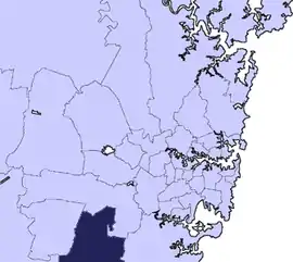 Location in Metropolitan Sydney | |||||||||||||||
| Coordinates | 34°04′S 150°49′E | ||||||||||||||
| Population |
| ||||||||||||||
| • Density | 509.4/km2 (1,319/sq mi) | ||||||||||||||
| Established | 1882 (Municipality) 4 May 1968 (as a city) | ||||||||||||||
| Area | 312 km2 (120.5 sq mi) | ||||||||||||||
| Mayor | George Brticevic (Labor) | ||||||||||||||
| Council seat | Campbelltown | ||||||||||||||
| Region | Greater Western Sydney | ||||||||||||||
| State electorate(s) | |||||||||||||||
| Federal Division(s) | |||||||||||||||
 | |||||||||||||||
| Website | City of Campbelltown | ||||||||||||||
| |||||||||||||||
The Mayor of the City of Campbelltown for 2016-18 is Cr. George Brticevic, a member of the Labor Party.
Suburbs
Suburbs in the City of Campbelltown are:
- Airds
- Ambarvale
- Bardia
- Blair Athol
- Blairmount
- Bow Bowing
- Bradbury
- Campbelltown
- Claymore
- Denham Court
- Eagle Vale
- Edmondson Park (South)
- Englorie Park
- Eschol Park
- Gilead
- Glen Alpine
- Glenfield
- Ingleburn
- Kearns
- Kentlyn
- Leumeah
- Long Point
- Macarthur Heights
- Macquarie Fields
- Macquarie Links
- Menangle Park
- Minto
- Minto Heights
- Raby
- Rosemeadow
- Ruse
- St Andrews
- St Helens Park
- Varroville
- Wedderburn
- Woodbine
Demographics
At the 2016 census there were 157,006 people in the Campbelltown local government area, of these 49% were male and 51% were female. Aboriginal and Torres Strait Islander people made up 3.8% of the population; 30% more than the NSW and Australian averages of 2.9% and 2.8% respectively. The median age of people in the City of Campbelltown was 34 years, which is significantly lower than the national median of 37 years. Children aged 0 – 14 years made up 21.6% of the population and people aged 65 years and over made up 11.8% of the population. Of people in the area aged 15 years and over, 47.1% were married and 87% were either divorced or separated.[1]
Over the 10-year period between the 2001 census and the 2011 census, the population of the Campbelltown Local Government Area increased by a recorded total of 673 people (0.46% increase in population over 10 years) from 145,294 people to 145,967 people. During that 10-year period the population had decreased by 1.53% at the 2006 census, and experienced a population increase of 2.02% over the subsequent five years to the 2011 census. At the 2016 census, the population in the Campbelltown Local Government Area increased by 7.56%. When compared with total population growth of Australia for the same period, being 8.8%, population growth in the Campbelltown Local Government Area was slightly below the national average.[3][4][5] The median weekly income for residents within the Campbelltown Local Government Area was generally on par with the national average.[1]
| Selected historical census data for Campbelltown local government area | ||||||
|---|---|---|---|---|---|---|
| Census year | 2001[3] | 2006[4] | 2011[5] | 2016[1] | ||
| Population | Estimated residents on census night | 145,294 | ||||
| LGA rank in terms of size within New South Wales | 19th | |||||
| % of New South Wales population | 2.11% | |||||
| % of Australian population | 0.77% | |||||
| Cultural and language diversity | ||||||
| Ancestry, top responses | Australian | 25.1% | ||||
| English | 22.1% | |||||
| Irish | 5.9% | |||||
| Scottish | 5.0% | |||||
| Indian | 2.9% | |||||
| Language, top responses (other than English) | Arabic | 2.3% | ||||
| Bengali | n/c | n/c | ||||
| Hindi | 1.2% | |||||
| Samoan | 1.4% | |||||
| Spanish | 1.8% | |||||
| Religious affiliation | ||||||
| Religious affiliation, top responses | Catholic | 32.1% | ||||
| No religion, so described | 9.1% | |||||
| Anglican | 25.9% | |||||
| Not stated | 8.3% | |||||
| Islam | 3.3% | |||||
| Median weekly incomes | ||||||
| Personal income | Median weekly personal income | A$464 | A$549 | A$632 | ||
| % of Australian median income | 99.6% | 95.1% | 95.5% | |||
| Family income | Median weekly family income | A$1,066 | A$1,390 | A$1,597 | ||
| % of Australian median income | 103.8% | 93.9% | 92.1% | |||
| Household income | Median weekly household income | A$1,156 | A$1,251 | A$1,459 | ||
| % of Australian median income | 98.7% | 101.4% | 101.4% | |||
Council
Current composition and election method
Campbelltown City Council is composed of fifteen Councillors elected proportionally as one entire ward. All Councillors are elected for a fixed four-year term of office. The Mayor is elected by the councillors at the first meeting of the council. The most recent Council election was held on 10 September 2016, and the makeup of the council is as follows:[6]

| Party | Councillors | |
|---|---|---|
| Labor Party | 8 | |
| Liberal Party | 3 | |
| Totally Locally Committed Party | 1 | |
| Community First Team | 1 | |
| The Greens | 1 | |
| Bob Thompson's Independent Team | 1 | |
| Total | 15 | |
The current Council, elected in 2016, in order of election, is:[6]
| Councillor | Party | Notes | |
|---|---|---|---|
| George Brticevic | Labor | Mayor | |
| George Greiss | Liberal | ||
| Paul Lake | Community First team | ||
| Meg Oates | Labor | Deputy Mayor | |
| Ted Rowell | Liberal | ||
| Darcy Lound | Labor | ||
| Margaret Chivers | Labor | ||
| Rey Manoto | Labor | ||
| Masood Chowdhury | Labor | ||
| Karen Hunt | Labor | ||
| Ben Moroney | Greens | ||
| Bob Thompson | Bob Thompson's Independent Team | ||
| Ralph George | Liberal | ||
| Warren Morrison | Totally Locally Committed | ||
| Ben Gilholme | Labor | ||
^a Cr. Borg died 20 December 2016. A by-election to elect a replacement councillor was held on 18 March 2017 and Ben Gilholme was elected.
Past Mayors
History and growth
Campbelltown was founded in 1820, named after Elizabeth Macquarie née Campbell,[7] wife of the then Governor Lachlan Macquarie. The town was one of a series of south-western settlements established by Macquarie at that time; the others include Ingleburn and Liverpool.
Campbelltown Council was originally incorporated on 21 January 1882.[8] The present boundaries of the City of Campbelltown were largely formed in 1949, following the amalgamation of the Municipalities of Ingleburn (incorporated in April 1896) and Campbelltown, as part of a rationalisation of local government areas across New South Wales following World War II. Campbelltown was presented with its own coat of arms in 1969. The coat of arms were based those on the arms of the Campbell family in Scotland.
Campbelltown was designated as a satellite city and a regional capital for the south west of Sydney in the early 1960s in the Sydney Region Outline Plan, prepared by the Planning Commission of New South Wales. There was extensive building and population growth in the intervening time and the government surrounded the township with areas which were set aside for public and private housing and industry.
Campbelltown was declared a city on 4 May 1968 by the Hon. Pat Morton, Minister for Local Government and Highways. That same day saw the arrival of the first electric train to Campbelltown from Sydney.
As a city, Campbelltown honoured the 1st Signals Regiment (now the 1st Joint Support Unit) with the medieval custom of the Freedom of the city. The Mayor, Alderman Clive Tregear, wanted to recognise the contribution to the units based at the Ingleburn Army Barracks. The Regiment marched through Campbelltown until it got transferred to Queensland in the 1980s.
Opened in 2005, the Campbelltown Arts Centre is a cultural facility of Campbelltown City Council that is partially funded by the New South Wales Government through Create NSW.[9]
Heritage listings
The City of Campbelltown has a number of heritage-listed sites, including:
- Campbelltown, Broughton Street: St John's Catholic Church, Campbelltown[10]
- Campbelltown, 8 Lithgow Street: Glenalvon House[11]
- Campbelltown, 14 - 20 Queen Street: Warbys Barn and Stables[12]
- Campbelltown, 261 Queen Street: Campbelltown Post Office[13]
- Campbelltown, 263 Queen Street: Commercial Banking Company of Sydney, Campbelltown Branch (former)[14]
- Campbelltown, 284 - 298 Queen Street: Queen Street Buildings[15]
- Campbelltown, 303 Queen Street: Dredges Cottage[16]
- Denham Court, 238 Campbelltown Road: Denham Court (homestead)[17]
- Gilead, 767 Appin Road: Beulah, Gilead[18]
- Gilead, Menangle Road: Sugarloaf Farm[19]
- Ingleburn, 196 Campbelltown Road: Robin Hood Farm[20]
- Kearns, Mississippi Crescent: Epping Forest, Kearns[21]
- Kentlyn, Darling Avenue: Bull Cave[22]
- Leumeah, Holly Lea Road: Holly Lea and Plough Inn[23]
- Macquarie Fields, Quarter Sessions Road: Macquarie Field House[24]
- Menangle Park, Glenlee Road: Glenlee, Menangle Park[25]
- Minto, Lot 315 Ben Lomond Road: Stone Cottage, Minto[26]
- St Helens Park, Appin Road: Denfield[27]
- St Helens Park, St Helens Park Drive: St Helen's Park[28]
- Varroville, 196 St Andrews Road: Varroville (homestead)[29]
Transport links
Road transport corridors
The principle access roads to and from Campbelltown are:
- Appin Road and The Hume Highway to the south;
- Narellan Road to the west; and
- The Hume Highway and Cambridge Avenue to the north.
There is no direct eastern road access. As a fast-growing regional centre, road infrastructure has yet to catch up with the historically strong population growth. Areas of greatest concern include congestion on Narellan Road,[30][31] numerous road fatalities on Appin Road and the inadequate causeway over the Georges River at Cambridge Avenue, Glenfield.[32]
Rail transport corridor
Campbelltown is served by trains on the Sydney suburban rail network (Sydney Trains), with railway stations:
- Macarthur Station in the south;
- Campbelltown;
- Leumeah;
- Minto;
- Ingleburn;
- Macquarie Fields; and
- Glenfield in the North.
Major council facilities
- Campbelltown Civic Centre, Queen Street, Campbelltown.
- Campbelltown Arts Centre, a contemporary arts centre located at the corner of Camden & Appin Roads, Campbelltown.
- Campbelltown Stadium, Leumeah, a sports stadium used mainly for football and rugby league.
- The Gordon Fetterplace Aquatic Centre, The Parkway, Bradbury.
- Eagle Vale Central, Emerald Drive, Eagle Vale.
- Macquarie Fields Indoor Sports Centre, Fields Road, Macquarie Fields.
- Macquarie Fields Leisure Centre, Fields Road, Macquarie Fields.
- HJ Daley Library, Hurley Street, Campbelltown.
- Greg Percival Library, corner of Oxford Road & Cumberland Road, Ingleburn.
- Glenquarie Library, Brooks Street, Macquarie Fields.
Festivals
- Festival of Fisher's Ghost: Held annually in the Campbelltown CBD every November. Campbelltown's biggest Festival and one of the longest running Festivals in Australia, dating back to 1956. Featuring 10 days of family fun with more than 30 events, including a grand parade of community groups a street fair, music gigs and fireworks.
- Ingleburn Alive! Festival: Held annually in Oxford Road in the Northern suburb of Ingleburn in March. Free entertainment, rides and family activities, usually followed by a firework display in Milton park.
- Riverfest, held annually in August in Koshigaya Park, to raise awareness of the city's local environment and cultural diversity.
References
- Australian Bureau of Statistics (27 June 2017). "Campbelltown (C)". 2016 Census QuickStats. Retrieved 5 July 2017.

- "3218.0 – Regional Population Growth, Australia, 2017-18". Australian Bureau of Statistics. 14 May 2020. Retrieved 14 May 2020. Estimated resident population (ERP) at 30 June 2018.
- Australian Bureau of Statistics (9 March 2006). "Campbelltown (C)". 2001 Census QuickStats. Retrieved 19 November 2012.
- Australian Bureau of Statistics (25 October 2007). "Campbelltown (C)". 2006 Census QuickStats. Retrieved 19 November 2012.
- Australian Bureau of Statistics (31 October 2012). "Campbelltown (C)". 2011 Census QuickStats. Retrieved 19 November 2012.
- "Campbelltown City Council: Summary of First Preference and Group Votes for each Candidate". Local Government Elections 2016. Electoral Commission of New South Wales. 16 September 2016. Retrieved 18 September 2016.
- "Mawson Park Campbelltown - Plaque". Panoramio. Roger Powell. 1988. Archived from the original (image) on 21 August 2017. Retrieved 19 November 2012.
- "Government Gazette Proclamations and Legislation - New South Wales Government Gazette (Sydney, NSW : 1832 - 1900) - 21 Jan 1882". National Library of Australia. Australian Government. Retrieved 3 March 2017.
- "About Us". Campbelltown Arts Centre. Retrieved 12 May 2020.
- "St. Johns Roman Catholic Church and Cemetery (former)". New South Wales State Heritage Register. Office of Environment and Heritage. H00193. Retrieved 18 May 2018.
- "Glenalvon". New South Wales State Heritage Register. Office of Environment and Heritage. H00004. Retrieved 18 May 2018.
- "Warbys Barn & Warbys Stables". New South Wales State Heritage Register. Office of Environment and Heritage. H00497. Retrieved 18 May 2018.
- "Campbelltown Post Office (former)". New South Wales State Heritage Register. Office of Environment and Heritage. H00265. Retrieved 18 May 2018.
- "CBC Bank". New South Wales State Heritage Register. Office of Environment and Heritage. H00499. Retrieved 18 May 2018.
- "Queen Street Buildings Group". New South Wales State Heritage Register. Office of Environment and Heritage. H00007. Retrieved 18 May 2018.
- "Dredges Cottage". New South Wales State Heritage Register. Office of Environment and Heritage. H00640. Retrieved 18 May 2018.
- "Denham Court". New South Wales State Heritage Register. Office of Environment and Heritage. H00212. Retrieved 18 May 2018.
- "Beulah". New South Wales State Heritage Register. Office of Environment and Heritage. H00368. Retrieved 18 May 2018.
- "Sugarloaf Farm". New South Wales State Heritage Register. Office of Environment and Heritage. H01389. Retrieved 18 May 2018.
- "Robin Hood Farm". New South Wales State Heritage Register. Office of Environment and Heritage. H01387. Retrieved 18 May 2018.
- "Epping Forest". New South Wales State Heritage Register. Office of Environment and Heritage. H01298. Retrieved 18 May 2018.
- "Bull Cave". New South Wales State Heritage Register. Office of Environment and Heritage. H01993. Retrieved 18 May 2018.
- "Holly Lea & Plough Inn". New South Wales State Heritage Register. Office of Environment and Heritage. H00343. Retrieved 18 May 2018.
- "Macquarie Field House". New South Wales State Heritage Register. Office of Environment and Heritage. H00424. Retrieved 18 May 2018.
- "Glenlee, outbuildings, garden & gatelodge". New South Wales State Heritage Register. Office of Environment and Heritage. H00009. Retrieved 18 May 2018.
- "Stone Cottage". New South Wales State Heritage Register. Office of Environment and Heritage. H01388. Retrieved 18 May 2018.
- "Denfield". New South Wales State Heritage Register. Office of Environment and Heritage. H00540. Retrieved 18 May 2018.
- "St. Helen's Park". New South Wales State Heritage Register. Office of Environment and Heritage. H00406. Retrieved 18 May 2018.
- "Varroville". New South Wales State Heritage Register. Office of Environment and Heritage. H00737. Retrieved 18 May 2018.
- Pleffer, Alexandra (11 April 2012). "Plea for new link to avoid gridlocked Narellan Road". Campbelltown Macarthur Advertiser. Retrieved 19 November 2012.
- Campbell, David (7 March 2011). "Macarthur roads named and shamed in RTA top-100 list". Macarthur Chronicle. Retrieved 19 November 2012.
- Campbell, David (2 August 2010). "Glenfield's Cambridge Ave causeway back for debate". Macarthur Chronicle. Retrieved 19 November 2012.
| Wikimedia Commons has media related to City of Campbelltown, New South Wales. |
External links
| Wikivoyage has a travel guide for Sydney/Macarthur. |