Grade II* listed buildings in Wakefield
There are over 20,000 Grade II* listed buildings in England. This page is a list of these buildings in the metropolitan borough of Wakefield in West Yorkshire.
List
| Name | Location | Type | Completed [note 1] | Date designated | Grid ref.[note 2] Geo-coordinates |
Entry number [note 3] | Image |
|---|---|---|---|---|---|---|---|
| Church of St Cuthbert | Ackworth, Wakefield | Parish Church | 15th century | 25 March 1968 | SE4403118076 53°39′26″N 1°20′07″W |
1313257 | 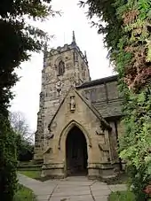 Church of St Cuthbert |
| Guide Post on Traffic Island at Junction with Station Road | Ackworth, Wakefield | Lamp Post | Later alterations | 25 March 1968 | SE4421017220 53°38′59″N 1°19′58″W |
1313251 |  |
| Quaker Meeting House with attached Lodges | Low Ackworth, Ackworth, Wakefield | Friends Meeting House | 1847 | 25 March 1968 | SE4414717281 53°39′01″N 1°20′01″W |
1135475 | .jpg.webp) Quaker Meeting House with attached Lodges |
| The Old Hall and attached Garden Wall to Front | High Ackworth, Ackworth, Wakefield | House | 1987 | 6 June 1952 | SE4383618022 53°39′25″N 1°20′17″W |
1355196 | 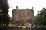 The Old Hall and attached Garden Wall to Front |
| Malt House approx. 15 Metres South West of Blacker Hall Farmhouse | Great Cliff, Crigglestone, Wakefield | Steps | Early-mid 17th century | 27 August 1986 | SE3002715747 53°38′15″N 1°32′50″W |
1135604 | |
| Church of All Saints | Crofton, Wakefield | Cross | Saxon | 22 November 1966 | SE3778818126 53°39′30″N 1°25′47″W |
1199946 |  Church of All Saints |
| Church of All Saints | Featherstone, Wakefield | Church | Probably C15(?) | 13 March 1964 | SE4218522090 53°41′37″N 1°21′45″W |
1288962 | 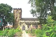 Church of All Saints |
| Grange Cottage | Featherstone, Wakefield | Farmhouse | 16th century | 9 October 1987 | SE4039020936 53°41′00″N 1°23′24″W |
1135538 | |
| Nostell Bridge | Huntwick with Foulby and Nostell, Wakefield | Road Bridge | 1761 | 25 March 1968 | SE4023917424 53°39′06″N 1°23′34″W |
1252808 |  Nostell Bridge |
| Obelisk Lodge and attached Screen Walls, at Se 406 18 | Nostell Priory, Huntwick with Foulby and Nostell, Wakefield | Lodge | 1776 | 25 March 1968 | SE4067018578 53°39′44″N 1°23′10″W |
1253564 | 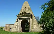 Obelisk Lodge and attached Screen Walls, at Se 406 18 |
| Church of All Saints | Normanton, Wakefield | Church | c. 1300 | 18 February 1965 | SE3873722539 53°41′52″N 1°24′53″W |
1253747 | 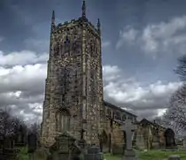 Church of All Saints |
| Sharlston Hall | Sharlston, Wakefield | Hall House | 15th century | 14 February 1952 | SE3956018884 53°39′54″N 1°24′10″W |
1253750 | .jpg.webp) Sharlston Hall |
| Netherton Hall | Netherton, Wakefield | House | c. 1775 | 14 February 1952 | SE2806116956 53°38′54″N 1°34′37″W |
1300218 | |
| Winding House, Heapstead and Headstock at Caphouse Colliery | Middlestown, Sitlington, Wakefield | Colliery | 1987 | 6 May 1988 | SE2534116451 53°38′38″N 1°37′05″W |
1135482 | 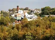 Winding House, Heapstead and Headstock at Caphouse Colliery |
| Iron Bridge across Lake to Walton Hall | Walton Park, Walton, Wakefield | Gate | c. 1800 | 22 November 1966 | SE3640016324 53°38′32″N 1°27′03″W |
1200153 | 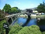 Iron Bridge across Lake to Walton Hall |
| Walton Hall | Walton Park, Walton, Wakefield | Country House | c. 1768 | 11 April 1973 | SE3637716255 53°38′30″N 1°27′04″W |
1135579 | 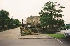 Walton Hall |
| Boat House on South Bank of the Half Moon Lake | Warmfield cum Heath, Wakefield | Boat House | Late 18th century | 27 August 1986 | SE3582320804 53°40′57″N 1°27′33″W |
1300638 | 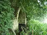 Boat House on South Bank of the Half Moon Lake |
| Church of St Peter | Kirkthorpe, Warmfield cum Heath, Wakefield | Church | 14th century | 22 November 1966 | SE3613720975 53°41′02″N 1°27′16″W |
1313216 | 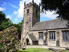 Church of St Peter |
| Dame Mary Bolle's Water Tower including Water Wheel Housing and Overflow Channel | Heath Common, Warmfield cum Heath, Wakefield | Gazebo | Early-mid 17th century | 27 August 1986 | SE3520119974 53°40′30″N 1°28′07″W |
1200499 |  Dame Mary Bolle's Water Tower including Water Wheel Housing and Overflow Channel |
| Deershed in Park at Heath Hall | Warmfield cum Heath, Wakefield | Deer House | Early-mid 18th century | 22 November 1966 | SE3569320496 53°40′47″N 1°27′40″W |
1135559 | |
| Heath House | Heath Common, Warmfield cum Heath, Wakefield | Country House | Mid 17th century | 14 February 1952 | SE3537820141 53°40′36″N 1°27′57″W |
1200517 | 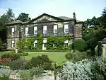 Heath House |
| Stable Building/barn at Heath Hall | Heath Common, Warmfield cum Heath, Wakefield | Garage | Early 18th century | 27 August 1986 | SE3552720261 53°40′39″N 1°27′49″W |
1135584 | |
| The Dower House | Heath Common, Warmfield cum Heath, Wakefield | House | 1952 | 14 February 1952 | SE3563320093 53°40′34″N 1°27′43″W |
1135585 | |
| Archway Lodge in Bretton Park including Flanking Walls | West Bretton, Wakefield | Gate Lodge | 1805-6 | 22 November 1966 | SE2894013131 53°36′50″N 1°33′50″W |
1313249 | .jpg.webp) Archway Lodge in Bretton Park including Flanking Walls |
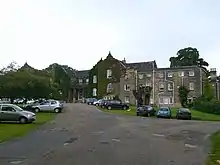
| Bretton Hall Including Attached Orangery to West | West Bretton, Wakefield | Country House | c. 1720 | 14 February 1952 | SE2836612779 53°36′39″N 1°34′22″W |
1184808 | 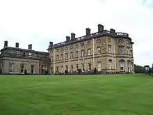 Bretton Hall Including Attached Orangery to West |
| Church in Bretton Park | West Bretton, Wakefield | Country House | 1744 | 22 November 1966 | SE2895212896 53°36′43″N 1°33′50″W |
1135462 | 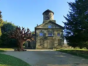 Church in Bretton Park |
| Stable Range in Bretton Park approx. 50 Metres North of Bretton Hall | West Bretton, Wakefield | Courtyard | 1853 | 22 November 1966 | SE2836712880 53°36′42″N 1°34′22″W |
1299930 | |
| Woolley Hall | Woolley Park, Woolley, Wakefield | Country House | c. 1635 | 14 February 1952 | SE3271013096 53°36′48″N 1°30′25″W |
1135534 | |
| Austin House | Wakefield | House | Late 18th century | 14 July 1953 | SE3266020602 53°40′51″N 1°30′25″W |
1273225 | 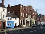 Austin House |
| Barclays Bank and attached Railings | Pontefract, Wakefield | House | c. 1760 | 29 July 1950 | SE4565421917 53°41′30″N 1°18′36″W |
1313285 | .jpg.webp) Barclays Bank and attached Railings |
| Boathouse at South West End of Lake in Grounds of Kettlethorpe Hall | Wakefield | Boat House | 1847 | 14 July 1953 | SE3320716518 53°38′39″N 1°29′57″W |
1258156 | |
| Calder and Hebble Navigation Warehouse on River Calder opposite Thornes Lane Wharf Grid Ref Se 3368 1988 | Wakefield | Warehouse | 1790 | 30 March 1971 | SE3368919871 53°40′27″N 1°29′29″W |
1242353 | 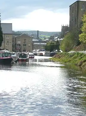 Calder and Hebble Navigation Warehouse on River Calder opposite Thornes Lane Wharf Grid Ref Se 3368 1988 |
| Church of All Saints | Wakefield | Church | 14th century | 29 July 1950 | SE4626622411 53°41′46″N 1°18′03″W |
1313269 |  Church of All Saints |
| Church of St Giles | Wakefield | Church | Early 18th century | 29 July 1950 | SE4555021898 53°41′30″N 1°18′42″W |
1135461 | _geograph.jpg.webp) Church of St Giles |
| Church of St Helen | Sandal, Wakefield | Tower | 12th century | 14 July 1953 | SE3435218225 53°39′34″N 1°28′54″W |
1242071 | 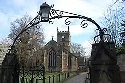 Church of St Helen |
| Church of St John the Baptist | Wakefield | Parish Church | 1791-5 | 30 March 1971 | SE3275321438 53°41′18″N 1°30′20″W |
1258554 |  Church of St John the Baptist |
| Church of St Joseph and attached Presbytery | Pontefract, Wakefield | Priests House | 1806 | 15 November 1988 | SE4522321901 53°41′30″N 1°19′00″W |
1135443 | 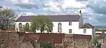 Church of St Joseph and attached Presbytery |
| Church of the Holy Trinity | Wakefield | Church | 1862-5 | 6 May 1988 | SE2765421146 53°41′10″N 1°34′58″W |
1184049 | 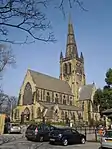 Church of the Holy Trinity |
| City Museum | Wakefield | Museum | 1820-1 | 30 March 1971 | SE3306820923 53°41′01″N 1°30′03″W |
1259120 | 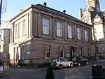 City Museum |
| Clarke Hall | Wakefield | House | Modern | 14 July 1953 | SE3420522116 53°41′40″N 1°29′00″W |
1260213 | |
| Crown Court House | Wakefield | House | 1810 | 30 March 1971 | SE3300320976 53°41′03″N 1°30′06″W |
1258996 | 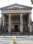 Crown Court House |
| Lucky Seven Bingo Club | Wakefield | Bingo Hall | 1894 | 1 February 1979 | SE3294420740 53°40′56″N 1°30′10″W |
1258906 | 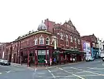 Lucky Seven Bingo Club |
| Lupset Hall | Lupset, Wakefield | House | 1716 | 14 July 1953 | SE3142019452 53°40′14″N 1°31′33″W |
1258152 | 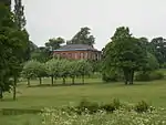 Lupset Hall |
| Market Cross and attached Pump | Pontefract, Wakefield | Market | 1734 | 29 July 1950 | SE4555521870 53°41′29″N 1°18′42″W |
1135455 | 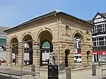 Market Cross and attached Pump |
| Milne's Orangery (Unitarian Chapel Hall) | Wakefield | Orangery | c. 1780 | 30 March 1971 | SE3279120799 53°40′57″N 1°30′18″W |
1242123 |  Milne's Orangery (Unitarian Chapel Hall) |
| Old Cathedral Grammar School | Wakefield | Grammar School | 1598 | 14 July 1953 | SE3332621028 53°41′05″N 1°29′49″W |
1358639 | 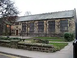 Old Cathedral Grammar School |
| Old Town Hall | Wakefield | Statue | 1785 | 29 July 1950 | SE4567221954 53°41′31″N 1°18′35″W |
1299877 |  Old Town Hall |
| Red Lion Hotel | Pontefract, Wakefield | Hotel | 1776 | 29 July 1950 | SE4561521932 53°41′31″N 1°18′39″W |
1299813 |  Red Lion Hotel |
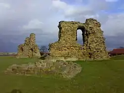
| Sandal Castle | Sandal, Wakefield | Castle | 1328 | 14 July 1953 | SE3372818159 53°39′32″N 1°29′28″W |
1366010 | |
| The Malt Shovel Public House | Pontefract, Wakefield | Public House | 14th century | 29 July 1950 | SE4545421895 53°41′30″N 1°18′47″W |
1135451 | 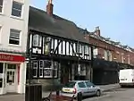 The Malt Shovel Public House |
| Westgate Unitarian Chapel | Wakefield | Unitarian Chapel | Later | 30 March 1971 | SE3283420762 53°40′56″N 1°30′16″W |
1260218 | |
| York House | Wakefield | House | Third quarter of 18th century | 14 July 1953 | SE3292520789 53°40′57″N 1°30′11″W |
1242813 | |
| 4 Grove Road | Wakefield | House | Early-Mid 18th century | 1 February 1979 | SE3360620413 53°40′45″N 1°29′34″W |
1258146 | |
| 138–148 Westgate | Wakefield | House | Late 18th century | 14 July 1953 | SE3270620624 53°40′52″N 1°30′23″W |
1258961 | |
| 2–24 St John's North | Wakefield | Terrace | Early-mid 19th century | 14 July 1953 | SE3282921502 53°41′20″N 1°30′16″W |
1258492 | 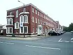 2–24 St John's North |
| 53 and 55 Northgate | Wakefield | Timber Framed House | Late 15th century | 12 February 1990 | SE3313221000 53°41′04″N 1°29′59″W |
1272883 | |
| 136 Westgate | Wakefield | House | Late 18th century | 14 July 1953 | SE3272220632 53°40′52″N 1°30′22″W |
1273196 | |
Notes
- The date given is the date used by Historic England as significant for the initial building or that of an important part in the structure's description.
- Sometimes known as OSGB36, the grid reference is based on the British national grid reference system used by the Ordnance Survey.
- The "List Entry Number" is a unique number assigned to each listed building and scheduled monument by Historic England.
External links
![]() Media related to Grade II* listed buildings in West Yorkshire at Wikimedia Commons
Media related to Grade II* listed buildings in West Yorkshire at Wikimedia Commons
This article is issued from Wikipedia. The text is licensed under Creative Commons - Attribution - Sharealike. Additional terms may apply for the media files.