Grade II* listed buildings in East Hampshire
There are over 20,000 Grade II* listed buildings in England. This page is a list of these buildings in the district of East Hampshire in Hampshire.
East Hampshire
| Name | Location | Type | Completed [note 1] | Date designated | Grid ref.[note 2] Geo-coordinates |
Entry number [note 3] | Image |
|---|---|---|---|---|---|---|---|
| Andrews Endowed C of E Primary School | Holybourne, Alton, East Hampshire | School | Modern | 13 March 1951 | SU7321040820 51°09′43″N 0°57′16″W |
1338937 |  |
| Bonham's Farm House | Holybourne, Alton | House | Late 17th century | 31 March 1977 | SU7421841758 51°10′13″N 0°56′23″W |
1094173 | |
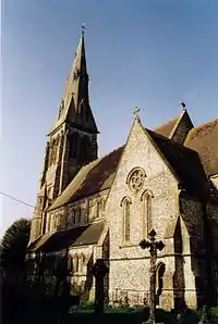
| Holy Rood Church | Holybourne, Alton | Church | Norman | 13 March 1951 | SU7324941244 51°09′57″N 0°57′14″W |
1179586 |  Holy Rood Church |
| Westbrooke House | Alton | House | Circa early 18th century | 13 March 1951 | SU7161839211 51°08′52″N 0°58′39″W |
1094199 | |
| Wyards Farm House | Beech | House | 1691 | 13 March 1951 | SU6982638894 51°08′42″N 1°00′11″W |
1179568 | |
| Church of St Mary | Bentley | Parish Church | 12th century | 31 July 1963 | SU7840844694 51°11′46″N 0°52′45″W |
1094090 |  Church of St Mary |
| Coldrey | Lower Froyle, Bentley | Timber Framed House | Mid 16th century | 31 July 1963 | SU7710743697 51°11′14″N 0°53′53″W |
1302259 | .jpg.webp) Coldrey |
| Marelands | Bentley | House | 16th century | 31 July 1963 | SU7936243863 51°11′19″N 0°51′57″W |
1094060 | |
| Former chapel immediately west of Hall Farmhouse | Bentworth | Boiler House | 1985 | 31 May 1985 | SU6630839977 51°09′19″N 1°03′12″W |
1094156 |  Former chapel immediately west of Hall Farmhouse |
| Church of St Mary | Bentworth | Parish Church | Late 12th century | 31 July 1963 | SU6654040289 51°09′29″N 1°03′00″W |
1094149 | |
| Hall Farmhouse | Bentworth | Farmhouse | 17th century | 31 July 1963 | SU6632839982 51°09′19″N 1°03′11″W |
1338928 | |
| Barn 30m north of West Court | Binsted | Barn | 15th century | 15 August 1985 | SU7658141140 51°09′52″N 0°54′22″W |
1338987 | |
| Bramshott Manor | Bramshott, Bramshott and Liphook | House | c. 1300 | 16 March 1954 | SU8422632851 51°05′20″N 0°47′56″W |
1094484 | |
| Bramshott Vale | Bramshott, Bramshott and Liphook | House | Early 18th century | 16 March 1954 | SU8371132899 51°05′22″N 0°48′22″W |
1094496 | |
| Church of St Mary | Bramshott, Bramshott and Liphook | Parish Church | c. 1220 | 16 March 1954 | SU8426632896 51°05′21″N 0°47′54″W |
1094480 | 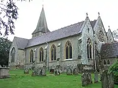 Church of St Mary |
| Passfield House | Passfield, Bramshott and Liphook | House | 16th century | 16 March 1954 | SU8244034507 51°06′14″N 0°49′26″W |
1351147 | |
| Tudor Gatehouse at Bramshott Place (King George's Hospital) | Bramshott and Liphook | Gatehouse | Early 16th century | 23 January 1986 | SU8450832219 51°04′59″N 0°47′42″W |
1236791 |  Tudor Gatehouse at Bramshott Place (King George's Hospital) |
| Barn at Old Ditcham Farm | Buriton | Barn | 17th century | 16 March 1954 | SU7603620324 50°58′38″N 0°55′06″W |
1094618 | |
| Church of St Mary | Buriton | Parish Church | 12th century | 16 March 1954 | SU7401520016 50°58′29″N 0°56′50″W |
1302500 | 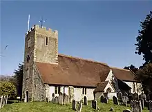 Church of St Mary |
| The Manor House | Buriton | Country House | 16th century | 16 March 1954 | SU7403620082 50°58′31″N 0°56′49″W |
1094597 | 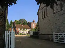 The Manor House |
| The Old Rectory | Buriton | House | 1986 | 16 March 1954 | SU7388820049 50°58′30″N 0°56′56″W |
1094622 | |
| Chawton House | Chawton | Country House | c. 1580 | 31 July 1963 | SU7087937026 51°07′41″N 0°59′19″W |
1093975 | |
| Church of St Nicholas | Chawton | Parish Church | Medieval | 31 July 1963 | SU7079137033 51°07′42″N 0°59′23″W |
1093974 |  Church of St Nicholas |
| The Manor House | Chawton | House | Late C20 | 31 July 1963 | SU7081337079 51°07′43″N 0°59′22″W |
1093971 |  The Manor House |
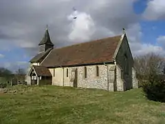
| Church of St Michael | Chalton, Clanfield | Parish Church | late 12th century or 13th century | 16 March 1954 | SU7320015945 50°56′18″N 0°57′35″W |
1302399 |  Church of St Michael |
| Manor Farmhouse | Chalton, Clanfield | Farmhouse | 15th century | 12 March 1986 | SU7328715978 50°56′19″N 0°57′30″W |
1351091 | |
| The Priory | Chalton, Clanfield | House | post 1540 | 12 March 1986 | SU7317515928 50°56′17″N 0°57′36″W |
1178520 | |
| Church of St Peter Ad Vincula | Colemore, Colemore and Priors Dean | Parish Church | 11th century | 16 March 1954 | SU7060030762 51°04′19″N 0°59′37″W |
1237037 | |
| Priors Dean Church | Priors Dean, Colemore and Priors Dean | Church | 1634 | 16 March 1954 | SU7278329601 51°03′40″N 0°57′46″W |
1237077 | 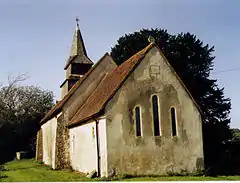 Priors Dean Church |
| Forge Sound | East Meon | House | c. 1600 | 29 January 1982 | SU6817522107 50°59′40″N 1°01′48″W |
1302212 | |
| Glenthorne and Forecourt Rail | East Meon | House | C20 | 16 March 1954 | SU6807622133 50°59′40″N 1°01′53″W |
1094591 | |
| Peak Farmhouse | East Meon | Farmhouse | 1728 | 16 March 1954 | SU6664325413 51°01′27″N 1°03′04″W |
1302347 | |
| Church of St James | East Tisted | Parish Church | Medieval | 31 July 1963 | SU7013032281 51°05′08″N 1°00′00″W |
1351138 |  Church of St James |
| Church of All Saints | Farringdon | Parish Church | 12th century | 31 July 1963 | SU7123735443 51°06′50″N 0°59′01″W |
1179147 |  Church of All Saints |
| Cruck Cottage | Farringdon | House | 15th century | 11 October 1985 | SU7115635326 51°06′46″N 0°59′06″W |
1093984 | |
| Manor House Farmhouse | Farringdon | House | 16th century | 16 December 1982 | SU7116135502 51°06′52″N 0°59′05″W |
1302182 | |
| Church of the Holy Trinity | Privett, Froxfield | Parish Church | 1876 to 1878 | 15 May 1978 | SU6767226966 51°02′17″N 1°02′10″W |
1237168 | |
| Trees Cottage | Bydean Farm, Froxfield | Base Cruck House | Mid 14th century | 23 January 1986 | SU7055026079 51°01′47″N 0°59′43″W |
1094460 | |
| Froyle Place | Upper Froyle, Froyle | Country House | of medieval origin | 31 July 1963 | SU7555442817 51°10′47″N 0°55′14″W |
1179185 | _p2.066_-_Froyle_Place%252C_Hampshire.jpg.webp) Froyle Place |
| Hodges Farmhouse | Lower Froyle, Froyle | Farmhouse | Later | 31 July 1963 | SU7577944407 51°11′38″N 0°55′01″W |
1302202 |  Hodges Farmhouse |
| Husseys | Lower Froyle, Froyle | House | 18th century | 31 July 1963 | SU7650544332 51°11′35″N 0°54′24″W |
1302242 | |
| Manor House | Upper Froyle, Froyle | House | 17th century | 31 July 1963 | SU7546442630 51°10′41″N 0°55′19″W |
1094104 | |
| Silvester's Farmhouse | Lower Froyle, Froyle | Farmhouse | Elizabethan | 31 July 1963 | SU7620244176 51°11′30″N 0°54′39″W |
1178980 | |
| Church of St Peter and St Paul | Upper Green, Hawkley | Church | On site of medieval church | 23 January 1986 | SU7458629162 51°03′25″N 0°56′14″W |
1094438 |  Church of St Peter and St Paul |
| Hill Place | Empshott, Hawkley | House | c. 1670 | 16 March 1954 | SU7548531242 51°04′32″N 0°55′26″W |
1351181 | |
| Suters | Headley | House | 15th century | 15 August 1985 | SU8216836235 51°07′10″N 0°49′39″W |
1093985 | |
| Church of All Saints | Catherington, Horndean | Parish Church | Late 12th century | 16 March 1954 | SU6964914516 50°55′33″N 1°00′37″W |
1094569 |  Church of All Saints |
| Church of St Nicholas | Kingsley | Chapel | 1778 | 31 May 1963 | SU7785437852 51°08′05″N 0°53′19″W |
1157331 |  Church of St Nicholas |
| Lasham House | Lasham | House | Early 18th century | 31 July 1963 | SU6756242347 51°10′35″N 1°02′06″W |
1094109 | |
| Church of St Peter | West Liss, Liss | Parish Church | Circa early 13th century | 16 March 1954 | SU7705128679 51°03′08″N 0°54′08″W |
1351203 | 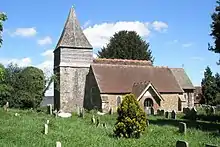 Church of St Peter |
| Dragon House | Petersfield | House | Early 18th century | 29 July 1949 | SU7482123064 51°00′08″N 0°56′06″W |
1179494 |  Dragon House |
| Goodyers | Petersfield | House | 16th century | 19 July 1949 | SU7446823172 51°00′11″N 0°56′24″W |
1339220 | |
| Heath Lodge | Petersfield | House | Late 18th century | 19 July 1949 | SU7497322857 51°00′01″N 0°55′59″W |
1093531 | |
| The Old College (Register Office) | Petersfield | House | 1729 | 29 July 1949 | SU7491523619 51°00′26″N 0°56′01″W |
1301953 | %252C_College_St%252C_Petersfield_2007_(Tony_Holkham).jpg.webp) The Old College (Register Office) |
| 9 and 11 Dragon Street | Petersfield | House | Early 18th century | 29 July 1949 | SU7480823104 51°00′09″N 0°56′07″W |
1339229 | |
| 1 The Square | Petersfield | House | Early 16th century | 29 July 1949 | SU7459723298 51°00′15″N 0°56′18″W |
1093564 |  1 The Square |
| Ropley House | Ropley | House | Mid 18th century | 31 July 1963 | SU6361031968 51°05′01″N 1°05′36″W |
1157351 | |
| Soames Place | Ropley | House | 15th century | 31 July 1963 | SU6545330696 51°04′19″N 1°04′02″W |
1339059 | |
| Blackmoor House | Blackmoor, Selborne | Flats | 1869 | 2 August 1973 | SU7798732870 51°05′23″N 0°53′16″W |
1094553 | |
| Church of St Matthew | Blackmoor, Selborne | Parish Church | 1868 | 31 July 1963 | SU7805033563 51°05′46″N 0°53′12″W |
1351142 |  Church of St Matthew |
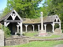
| Blackmoor War Memorial | Blackmoor, Selborne | War memorial | 1920 | 18 July 1986 | SU7800733588 51°05′47″N 0°53′15″W |
1174603 | |
| Manor Farmhouse | Shalden | Farmhouse | 16th century | 31 May 1985 | SU6959742049 51°10′24″N 1°00′21″W |
1179466 |  Manor Farmhouse |
| Church of All Saints | Steep | Parish Church | 12th century | 16 March 1954 | SU7458825298 51°01′20″N 0°56′17″W |
1351171 |  Church of All Saints |
| Coldhayes | Steep Marsh, Steep | Country House | 1869 | 23 January 1986 | SU7564826943 51°02′13″N 0°55′21″W |
1351190 | |
| Church of St Mary Magdalene | West Tisted | Parish Church | 11th century | 31 July 1963 | SU6501929211 51°03′31″N 1°04′25″W |
1351153 | 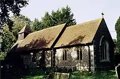 Church of St Mary Magdalene |
| Church of St Leonard | Hartley Mauditt, Worldham | Parish Church | Early 12th century | 31 July 1963 | SU7429736105 51°07′10″N 0°56′23″W |
1094509 | |
| Church of St Mary | East Worldham, Worldham | Parish Church | 13th century | 31 July 1963 | SU7506038128 51°08′15″N 0°55′43″W |
1351156 | 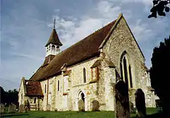 Church of St Mary |
| Hartley Mauditt House | Hartley Mauditt, Worldham, East Hampshire | House | after 1820 | 18 July 1986 | SU7424036540 51°07′24″N 0°56′26″W |
1351158 | |


Notes
- The date given is the date used by Historic England as significant for the initial building or that of an important part in the structure's description.
- Sometimes known as OSGB36, the grid reference is based on the British national grid reference system used by the Ordnance Survey.
- The "List Entry Number" is a unique number assigned to each listed building and scheduled monument by Historic England.
External links
![]() Media related to Grade II* listed buildings in Hampshire at Wikimedia Commons
Media related to Grade II* listed buildings in Hampshire at Wikimedia Commons
This article is issued from Wikipedia. The text is licensed under Creative Commons - Attribution - Sharealike. Additional terms may apply for the media files.
