Grade II* listed buildings in Gloucester
There are over 20,000 Grade II* listed buildings in England. This page is a list of these buildings in the district of Gloucester in Gloucestershire.
Gloucester
| Name | Location | Type | Completed [note 1] | Date designated | Grid ref.[note 2] Geo-coordinates |
Entry number [note 3] | Image |
|---|---|---|---|---|---|---|---|
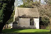
| Church of St James | Quedgeley, Gloucester | Parish Church | 14th century | 10 January 1955 | SO8071614182 51°49′33″N 2°16′52″W |
1090771 | |
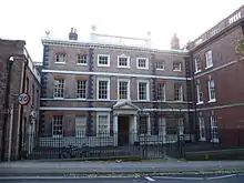
| Bearland House and attached Railings and Gates to Forecourt | Gloucester | House | Late 17th century or Early 18th century | 7 September 1970 | SO8293918570 51°51′56″N 2°14′57″W |
1245728 | |
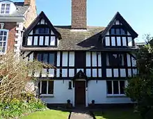
| Bearland Lodge | Gloucester | Town House | c. 1720 | 23 January 1952 | SO8295718563 51°51′55″N 2°14′56″W |
1245727 | 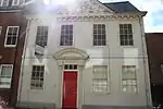 Bearland Lodge |
| Boundary Wall to North West Corner of Friary Site, Blackfriars | Gloucester | Boundary Wall | 1540–1545 | 12 March 1973 | SO8294918461 51°51′52″N 2°14′56″W |
1245990 |  |
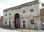
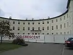
| Central Block to HM Prison | Gloucester | Prison | 1784–1790 | 12 March 1973 | SO8281318525 51°51′54″N 2°15′04″W |
1245474 | |
| Chapel of St Mary Magdalene Remains of Chapel of St Mary Magdalene | Gloucester | Chapel | Mid 12th century | 23 January 1952 | SO8432318988 51°52′09″N 2°13′45″W |
1245744 | |
| Church of St Barnabas | Tuffley, Gloucester | Parish Church | 1938–1940 | 9 March 1982 | SO8339215808 51°50′26″N 2°14′33″W |
1271790 | |
| Church of St John, Northgate | Gloucester | Methodist Chapel | 1972 | 23 January 1952 | SO8324318683 51°51′59″N 2°14′41″W |
1245673 | 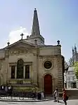 Church of St John, Northgate |
| Church of St Lawrence | Barnwood, Gloucester | Parish Church | Mid 12th century | 10 January 1955 | SO8584117755 51°51′30″N 2°12′25″W |
1271586 | 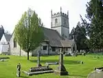 Church of St Lawrence |
| Church of St Swithun | Hempsted, Gloucester | Parish Church | 14th century | 10 January 1955 | SO8135917034 51°51′06″N 2°16′19″W |
1271743 | 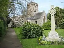 Church of St Swithun |
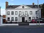
| Deaf Institute | Gloucester | Town House | c. 1690 | 23 January 1952 | SO8294618856 51°52′05″N 2°14′57″W |
1245666 | 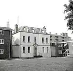 Deaf Institute |
| Dulverton House (Kings School) | Gloucester | Abbey | 13th century | 23 January 1952 | SO8317018847 51°52′05″N 2°14′45″W |
1245957 | 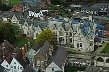 Dulverton House (Kings School) |
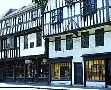
| Folk Museum | Gloucester | Jettied House | c. 1645 | 23 January 1952 | SO8286218771 51°52′02″N 2°15′01″W |
1245075 | |
| Folk Museum (Bishop Hooper's Lodging) | Gloucester | Jettied House | c. 1520 | 23 January 1952 | SO8287118765 51°52′02″N 2°15′01″W |
1245071 | _2.JPG.webp) Folk Museum (Bishop Hooper's Lodging) |
| Horton Road Hospital including Area Railings | Gloucester | Fireproof Building | 1814–1823 | 28 May 1991 | SO8438318527 51°51′54″N 2°13′42″W |
1271680 | |
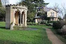
| Kings Board, Hillfield Gardens | Gloucester | Gazebo | Late 18th century | 23 January 1952 | SO8425618976 51°52′09″N 2°13′48″W |
1245719 | |
| King Edward's Gate | Gloucester | House | 1998 | 23 January 1952 | SO8303118732 51°52′01″N 2°14′52″W |
1245909 | |
| Kings School and Remains of Abbots Lodging | Gloucester | Bishops Palace | 1541 | 12 March 1973 | SO8311518902 51°52′06″N 2°14′48″W |
1245960 | Kings School and Remains of Abbots Lodging |
| Northgate House and attached Walls and Railings to Forecourt | Gloucester | House | Mid to late 17th century | 23 January 1952 | SO8361018804 51°52′03″N 2°14′22″W |
1271700 | |
| 20, College Green and part of Abbey Precinct Wall | Gloucester | House | 18th century | 12 March 1973 | SO8310918694 51°52′00″N 2°14′48″W |
1245904 | |
| Robert Raikes' House | Gloucester | House | 19th century | 23 January 1952 | SO8306918463 51°51′52″N 2°14′50″W |
1271757 | |
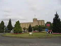
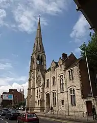
| Roman Catholic Church of St Peter | Gloucester | Roman Catholic Church | 1860–1868 | 12 March 1973 | SO8351218781 51°52′02″N 2°14′27″W |
1245721 | |
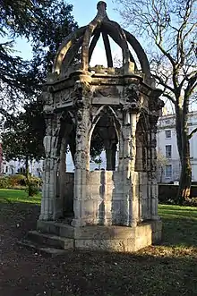
| Hillfield Gardens, Gloucester#Scrivens Conduit, Hillfield Gardens | Gloucester | Conduit Head | 1636 | 25 January 1952 | SO8422418971 51°52′09″N 2°13′50″W |
1245720 | |
| Selwyn Care Home and attached Wall | Matson, Gloucester | Manor House | c. 1575 | 23 January 1952 | SO8481515463 51°50′15″N 2°13′18″W |
1245730 | |
| Sherborne House | Gloucester | House | c. 1825 | 25 January 1952 | SO8296817989 51°51′37″N 2°14′55″W |
1245621 | |
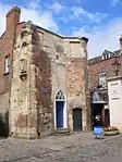
| St Margarets Chapel | Gloucester | Chapel | Before 1163 | 23 January 1952 | SO8411418909 51°52′07″N 2°13′56″W |
1245723 | |
| St Mary De Crypt Grammar School | Gloucester | Church Hall | 1862 | 23 January 1952 | SO8308118439 51°51′51″N 2°14′50″W |
1271755 | 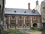 St Mary De Crypt Grammar School |
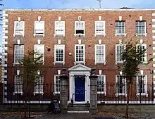
| The Deanery and attached Forecourt Walls and Railings | Gloucester | House | 1731–1741 | 23 January 1952 | SO8303718882 51°52′06″N 2°14′52″W |
1271712 | 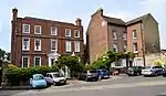 The Deanery and attached Forecourt Walls and Railings |
| The Judges Lodgings and attached Front Piers Walls and Balustrades | Gloucester | Apartment | 1998 | 25 January 1952 | SO8299617975 51°51′36″N 2°14′54″W |
1245622 | |
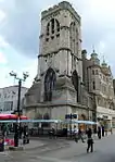
| Tower of the former Church of St Michael | Gloucester | Parish Church | 1455–1472 | 23 January 1952 | SO8317018541 51°51′55″N 2°14′45″W |
1245822 | |
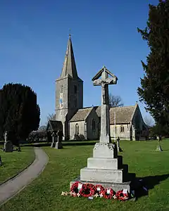
| Village Cross (at Corner of Rea Lane) | Hempsted, Gloucester | Village Cross | Early 15th century | 10 January 1955 | SO8146716949 51°51′03″N 2°16′14″W |
1271745 | 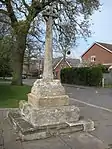 Village Cross (at Corner of Rea Lane) |
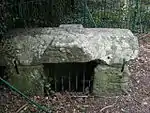
| Well Cross in Robins Wood Hill Country Park at SO 838 158 | Gloucester | Cistern | 12th century or 13th century | 15 December 1998 | SO8387015848 51°50′28″N 2°14′08″W |
1245660 | |
| Winston Hall | Gloucester | Town House | 1750 | 23 January 1952 | SO8323818375 51°51′49″N 2°14′41″W |
1271655 | |
| House (6, Westgate Street) | Gloucester | House | 16th century | 12 March 1973 | SO8315318590 51°51′56″N 2°14′46″W |
1245438 | |
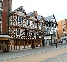
| House (14 Westgate Street) | Gloucester | House | Early to Mid 18th century | 23 January 1952 | SO8313918607 51°51′57″N 2°14′47″W |
1245445 | 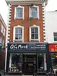 House (14 Westgate Street) |
| House (33, Westgate Street) | Gloucester | House | C20 | 12 March 1973 | SO8307618626 51°51′57″N 2°14′50″W |
1271925 | 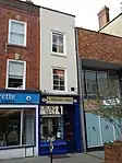 House (33, Westgate Street) |
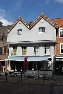
| 47 and 49, Westgate Street | Gloucester | House | Late 18th century | 23 January 1952 | SO8304518649 51°51′58″N 2°14′52″W |
1271930 | 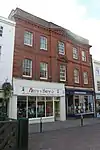 47 and 49, Westgate Street |
| 66, Westgate Street | Gloucester | Shop | 19th century | 23 January 1952 | SO8300418708 51°52′00″N 2°14′54″W |
1245228 | |
| House (74 and 76, Westgate Street) | Gloucester | House | After Early 16th century | 10 December 1973 | SO8298618725 51°52′01″N 2°14′55″W |
1245230 | 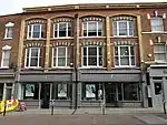 House (74 and 76, Westgate Street) |
| House (1 and 3, Berkeley Street/56 and 61, Westgate Street) | Gloucester | House | C20 | 23 January 1952 | SO8301918662 51°51′59″N 2°14′53″W |
1245225 | |
| Abbey (14, College Green) | Gloucester | Abbey | Early 15th century | 23 January 1952 | SO8300318854 51°52′05″N 2°14′54″W |
1245896 | 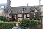 Abbey (14, College Green) |
| House (9, College Green) | Gloucester | House | 1708–1709 | 23 January 1952 | SO8298918796 51°52′03″N 2°14′54″W |
1271600 | 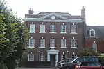 House (9, College Green) |
| House (29 and 31, Southgate Street) | Gloucester | House | C20 | 23 January 1952 | SO8309618451 51°51′52″N 2°14′49″W |
1271754 | 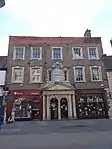 House (29 and 31, Southgate Street) |
| House (5–11, College Street) | Gloucester | House | Later alterations | 23 January 1952 | SO8302318714 51°52′00″N 2°14′53″W |
1245908 | 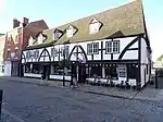 House (5–11, College Street) |
| House (13, Ladybellegate Street) | Gloucester | House | c. 1540 | 23 January 1952 | SO8294118428 51°51′51″N 2°14′57″W |
1245752 | |
| House (15, Ladybellegate Street) | Gloucester | House | c. 1540 | 23 January 1952 | SO8293818423 51°51′51″N 2°14′57″W |
1245753 | |
| House (17, Ladybellegate Street) | Gloucester | House | c. 1540 | 23 January 1952 | SO8293518418 51°51′51″N 2°14′57″W |
1245754 | |
| Abbey (3, Millers Green) | Gloucester | Abbey | 12th century | 23 January 1952 | SO8309618870 51°52′05″N 2°14′49″W |
1271714 | 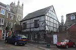 Abbey (3, Millers Green) |
| Gloucester Public Library | Gloucester | Library | 1872 | 12 March 1973 | SO8313018357 51°51′47″N 2°14′42″W |
1245965 | |
| 12–18 Brunswick Square | Gloucester | Terrace | 1825 | 23 January 1952 | SO 8299618105 51°51′41″N 2°14′53″W |
1245974 | |
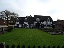
| The Little Thatch | Quedgeley | House | 1351 | 30 September 1985 | SO8106514463 51°49′43″N 2°16′33″W |
131814 |
.jpg.webp)
Notes
- The date given is the date used by Historic England as significant for the initial building or that of an important part in the structure's description.
- Sometimes known as OSGB36, the grid reference is based on the British national grid reference system used by the Ordnance Survey.
- The "List Entry Number" is a unique number assigned to each listed building and scheduled monument by Historic England.
External links
![]() Media related to Grade II* listed buildings in Gloucestershire at Wikimedia Commons
Media related to Grade II* listed buildings in Gloucestershire at Wikimedia Commons
This article is issued from Wikipedia. The text is licensed under Creative Commons - Attribution - Sharealike. Additional terms may apply for the media files.