Grade II* listed buildings in Gravesham
There are over 20,000 Grade II* listed buildings in England. This page is a list of these buildings in the district of Gravesham in Kent.
Gravesham
| Name | Location | Type | Completed [note 1] | Date designated | Grid ref.[note 2] Geo-coordinates |
Entry number [note 3] | Image |
|---|---|---|---|---|---|---|---|
| Meadow House | Cobham, Gravesham | House | 1770 | 21 November 1966 | TQ6699068623 51°23′31″N 0°23′56″E |
1373849 |  |
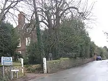
| Owletts | Cobham | House | 1683/1684 | 27 August 1952 | TQ6651068734 51°23′36″N 0°23′31″E |
1049097 | |
| The Dairy, Cobham Hall | Cobham | Dairy | c. 1790 | 22 June 1982 | TQ6833668617 51°23′30″N 0°25′05″E |
1350898 | |
| Parish Church of St Peter and St Paul | Luddesdown | Parish Church | 13th century | 21 November 1966 | TQ6695566177 51°22′12″N 0°23′50″E |
1096342 | 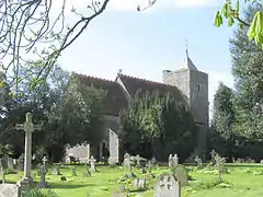 Parish Church of St Peter and St Paul |
| Church of St Mildred | Nurstead, Meopham | Church | Perhaps earlier | 21 November 1966 | TQ6412368279 51°23′23″N 0°21′27″E |
1096351 |  Church of St Mildred |
| Killick's Mill, Meopham | Meopham | Smock Mill | 1801 | 22 August 1952 | TQ6394765183 51°21′43″N 0°21′13″E |
1054722 | |
| Church of St Peter and St Paul | Shorne | Church | 12th century | 21 November 1966 | TQ6906171020 51°24′47″N 0°25′47″E |
1083891 | 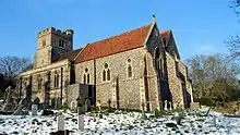 Church of St Peter and St Paul |
| Little St Katherine's | Shorne | House | 19th century | 27 August 1952 | TQ6925171459 51°25′01″N 0°25′57″E |
1083895 | 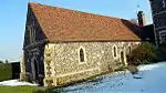 Little St Katherine's |
| Church of All Saints | Northfleet | Parish Church | 1869-70 | 30 July 1986 | TQ6355273114 51°26′00″N 0°21′05″E |
1346415 | 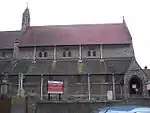 Church of All Saints |
| Church of Our Lady of the Assumption | The Hill, Northfleet | Roman Catholic Church | 1913-16 | 26 July 1983 | TQ6247574089 51°26′33″N 0°20′11″E |
1081094 | 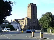 Church of Our Lady of the Assumption |
| Church of St George | Gravesend | Parish Church | 1731-1732 | 23 January 1952 | TQ6468974341 51°26′39″N 0°22′06″E |
1089034 | 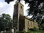 Church of St George |
| Church of St Mary | Chalk | Parish Church | Late C11/early 12th century | 23 January 1952 | TQ6832572498 51°25′35″N 0°25′11″E |
1089044 | 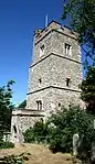 Church of St Mary |
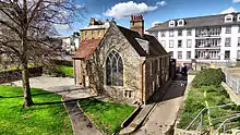
| Church of St Peter and St Paul | Milton-next-Gravesend | Parish Hall | 1992 | 23 January 1952 | TQ6589773831 51°26′21″N 0°23′08″E |
1341484 | 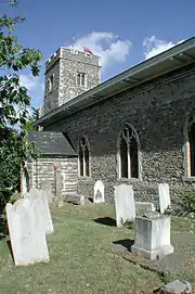 Church of St Peter and St Paul |
| Ifield Court | Ifield Court, Northfleet | House | 18th century | 4 July 1952 | TQ6478569957 51°24′17″N 0°22′04″E |
1350208 | 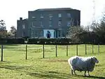 Ifield Court |
| Milton Chantry | Milton-next-Gravesend | House | Reformation | 23 January 1952 | TQ6525474338 51°26′38″N 0°22′35″E |
1089047 | |
| New Tavern Fort | Gravesend | Artillery Fort | Begun 1869 | 24 February 1977 | TQ6529274238 51°26′35″N 0°22′37″E |
1261173 |  New Tavern Fort |
| The Old Rectory House | Northfleet | House | After 1656 | 4 July 1952 | TQ6233173419 51°26′11″N 0°20′03″E |
1081093 | |
| The Town Hall | Gravesend | Town Hall | 1836 | 23 January 1952 | TQ6477974271 51°26′36″N 0°22′11″E |
1054761 | 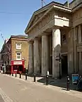 The Town Hall |
| The Town Pier | Gravesend | Pier | 1831-1834 | 3 July 1975 | TQ6477474480 51°26′43″N 0°22′11″E |
1089004 | 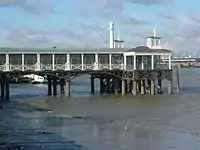 The Town Pier |
| 80 High Street | Gravesend | House | Early to mid 18th century | 19 March 1974 | TQ6475774398 51°26′41″N 0°22′10″E |
1367090 | |

Notes
- The date given is the date used by Historic England as significant for the initial building or that of an important part in the structure's description.
- Sometimes known as OSGB36, the grid reference is based on the British national grid reference system used by the Ordnance Survey.
- The "List Entry Number" is a unique number assigned to each listed building and scheduled monument by Historic England.
External links
![]() Media related to Grade II* listed buildings in Kent at Wikimedia Commons
Media related to Grade II* listed buildings in Kent at Wikimedia Commons
This article is issued from Wikipedia. The text is licensed under Creative Commons - Attribution - Sharealike. Additional terms may apply for the media files.